English II 2020
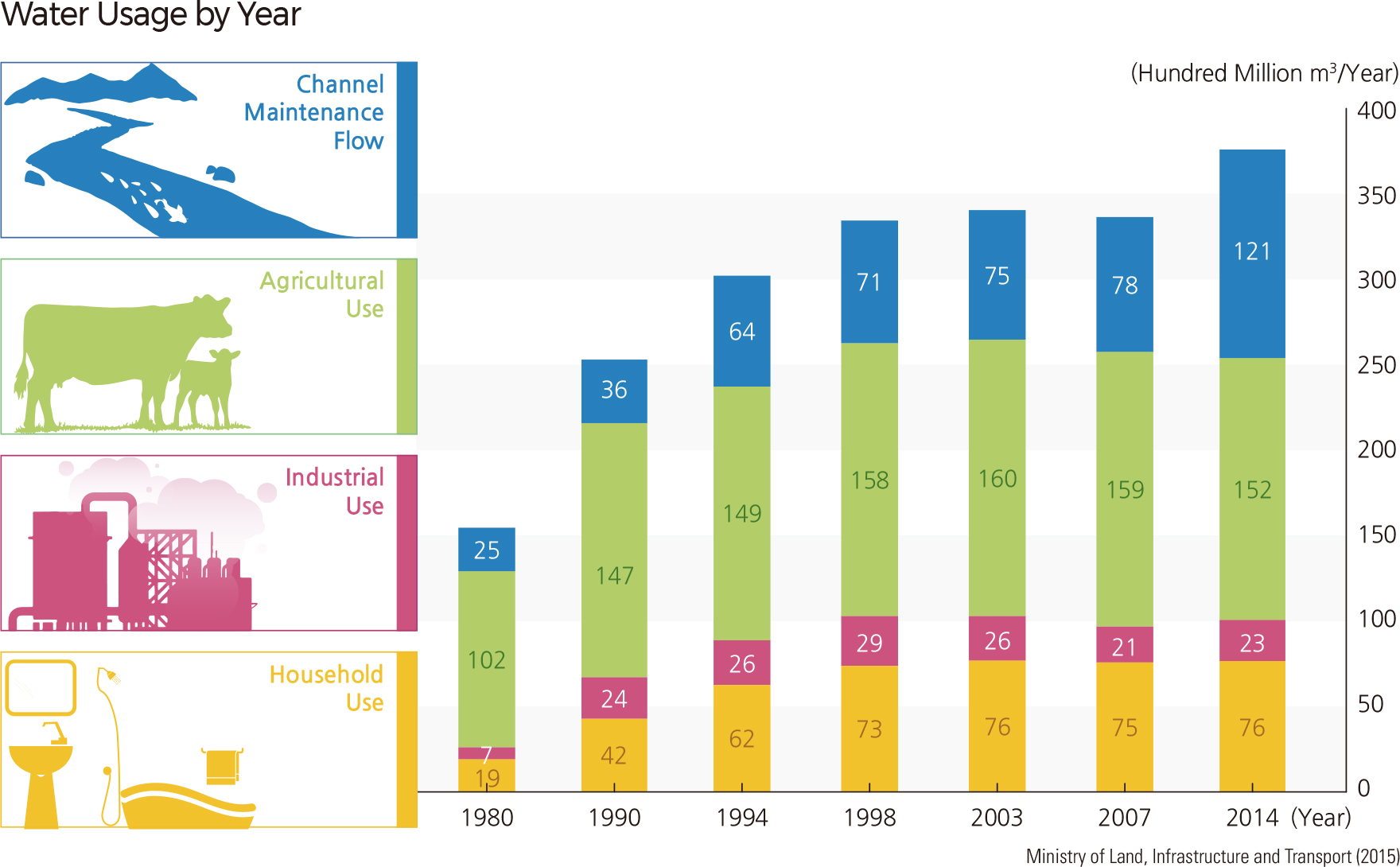
The total water use of Korea increased more than six times from 5.12 billion ㎥ in the 1960s to 33billion ㎥ in the 1990s. This steep rise can be attributed to population growth, economic advancement, increased industrial development, and an increasing number of irrigation facilities. Accordingly, channel maintenance flow also increased to protect water quality, ecosystems, and landscapes. Since the 2000s, however, the rate of increase for water usage has been slowing down.
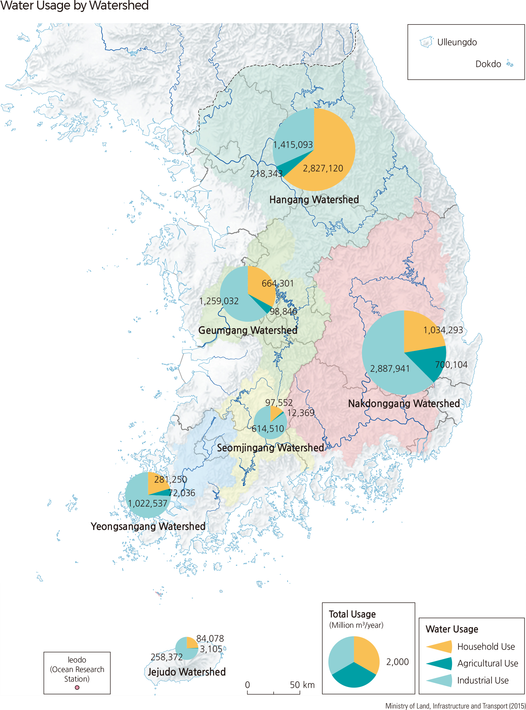
In 2014, agricultural use accounted for the largest proportion of total water use at 40.9%, followed by channel maintenance flow (32.5%), domestic use (20.4%), and industrial use (6.2%). Domestic and industrial water usage has remained about the same since 1998, while agricultural use has experienced a decrease over the same time period. On the other hand, channel maintenance flow – which is used for maintaining river functions – has gradually increased. As of 2011, the Hangang watershed was recorded as the largest area of water use at 5.23 billion ㎥, followed by the Nakdonggang watershed (5.1 billion ㎥), Geumgang watershed (2.61 billion ㎥), Yeongsangang watershed (1.5 billion ㎥), and Seomjingang watershed (0.9 billion ㎥).
In the Hangang watershed, domestic water use took the highest proportion of water use at 63.4%, while agricultural and industrial water use accounted for 31.7% and 4.9%, respectively. For all other watersheds, agricultural water use had the highest proportion, followed by domestic and industrial water use. The rate of domestic water use is highest in the Hangang watershed due to the large population that inhabits the area. Large industrial complexes contribute to the relatively high rate of industrial water use in the Nakdonggang watershed (15.1%), while a smaller population and fewer industrial facilities are responsible for the relatively high rate of agricultural water use in the Seomjingang watershed (84.8%).
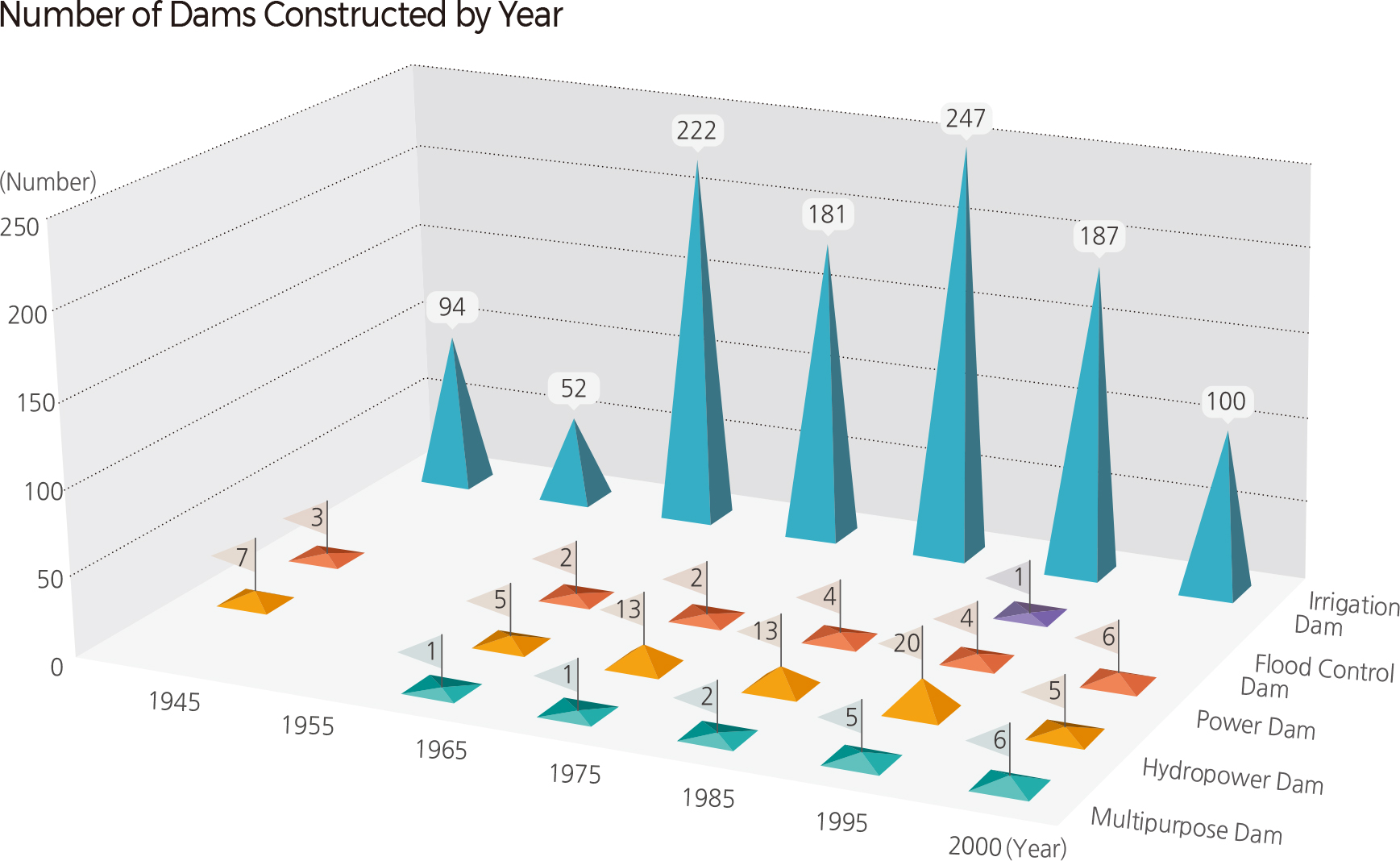
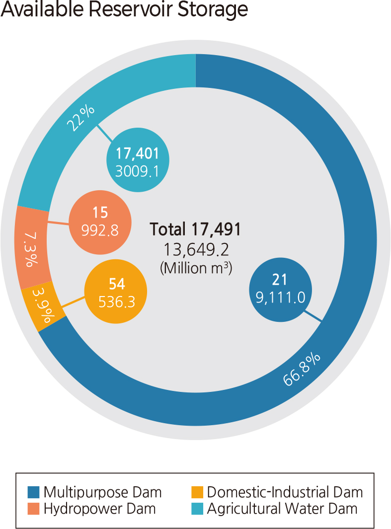
As of 2014, Korea has a total of 17,735 dams and reservoirs, including those under construction. This number includes 20 multipurpose dams, 54 domestic and industrial dams, and 12 hydroelectric dams, with the rest being small-scale agricultural dams. In terms of hydropower capacity, multipurpose dams account for 68.1% of all structures. There are also two dams for flood control: "Dam for Peace" and Gunnam Flood Control Reservoir. The Hantangang Dam was recently completed.
The distribution of dams by watershed indicates that 27 are located in the Nakdonggang watershed, 24 in each of the Hangang and Geumgang watersheds, and nine in each of the Yeongsangang and Seomjingang watersheds. In the Hangang watershed, 37.5% of the dams are hydroelectric dams, while 33.3% are hydropower dams. Domestic/industrial (37.0%) and multipurpose (29.6%) dams account for 66.6% of dams in the Nakdonggang watershed. Agricultural dams account for about 75% of Geumgang dams and 77.8% of Yeongsangang dams, while all types of dams are relatively evenly distributed in the Seomjingang watershed. Overall, the Nakdonggang watershed has the most multipurpose and domestic/industrial dams, the Geumgang watershed has the most agricultural dams, and the Hangang watershed has the most hydroelectric dams.
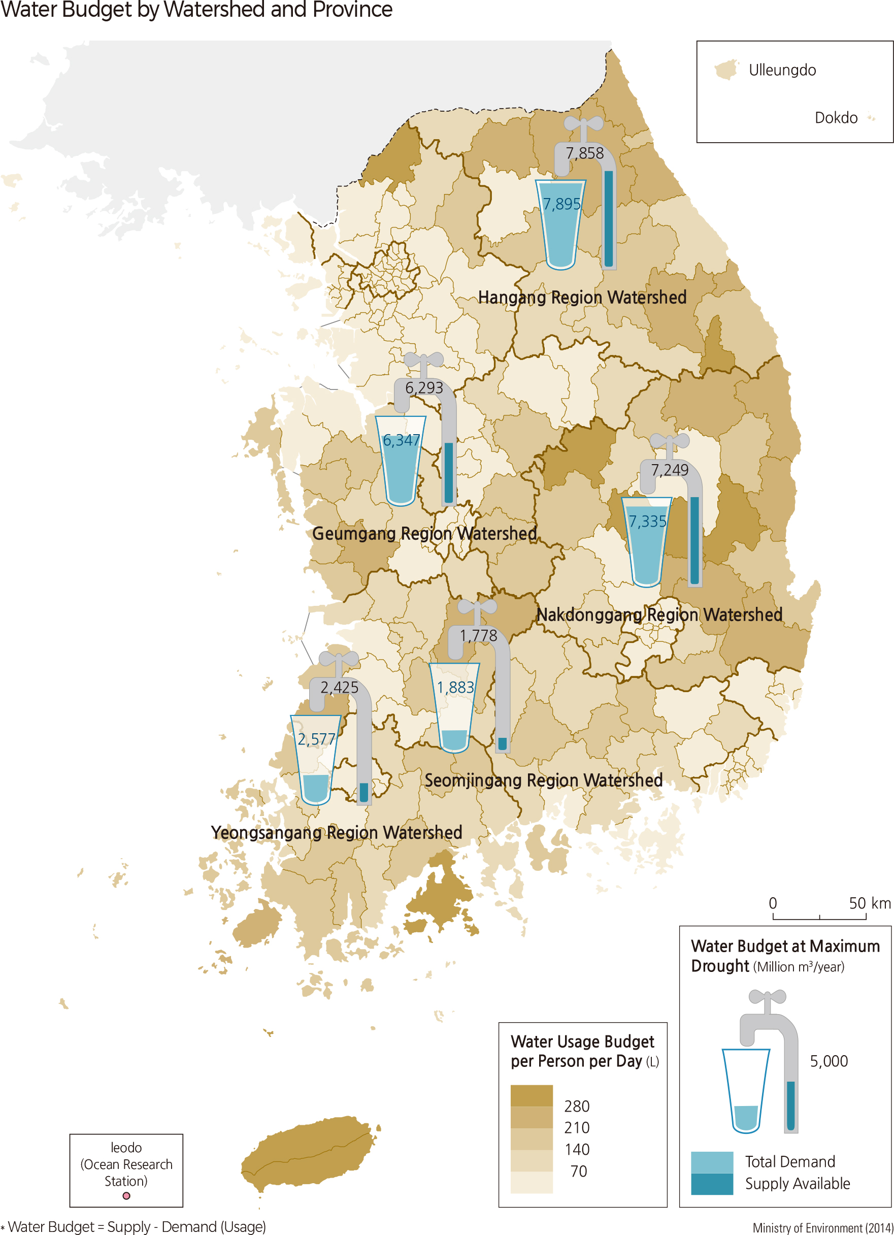
The "Major Rivers Restoration Project" was launched in February 2009 to promote local development by building weirs, thus securing water resources, enhancing water quality, and developing the leisure industry. A total of 16 weirs were newly installed on the four rivers (Hangang, Nakdonggang, Geumgang, and Yeongsangang). Various leisure facilities such as riverside parks and bicycle paths were created as well. However, there are serious ongoing debates concerning water quality degradation and the effectiveness of the project. According to the Long-Term Water Master Plan (2011–2020), Korea is projected to have a water shortage of 0.43 million ㎥ if severe drought occurs in 2020. The prediction states that the Yeongsangang watershed will have the largest shortage (0.15 billion ㎥), followed by the Seomjingang watershed (0.1 billion ㎥), the Nakdonggang watershed (0.09 billion ㎥), the Geumgang watershed (0.05 billion ㎥), and the Hangang watershed (0.04 billion ㎥). Coastal regions, islands, and mountain areas will most likely experience the greatest lack of available water due to a deterioration of water resources or supply systems.
Various plans are required to prevent the projected water shortage across the nation; an integrated supply system for waterworks must be established, existing facilities should be maintained to uphold effective operation, and small reservoirs should be constructed to obtain new water sources. Global climate change may further intensify the water shortage by 1.8–3.5 times by extending droughts and increasing demand for water. As such, it is also necessary to facilitate the capability to cope with such potential extreme water shortages. According to the Long-Term Water Master Plan (2011–2020), Korea is projected to have a water shortage of 0.43 million ㎥ if severe drought occurs in 2020. The prediction states that the Yeongsangang watershed will have the largest shortage (0.15 billion ㎥), followed by the Seomjingang watershed (0.1 billion ㎥), the Nakdonggang watershed (0.09 billion ㎥), the Geumgang watershed (0.05 billion ㎥), and the Hangang watershed (0.04 billion ㎥). Coastal regions, islands, and mountain areas will most likely experience the greatest lack of available water due to a deterioration of water resources or supply systems.
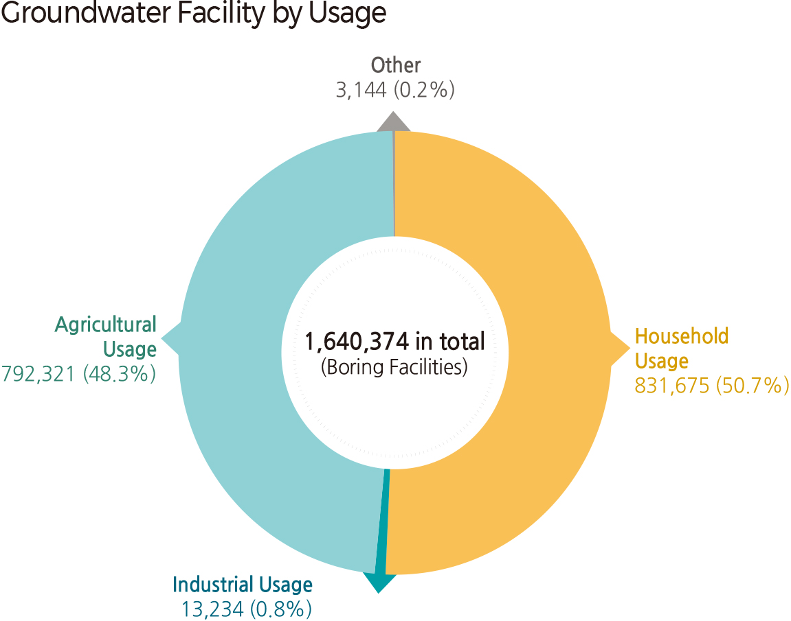
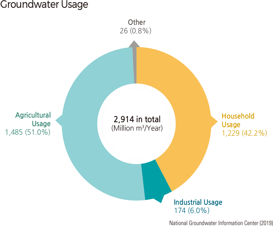
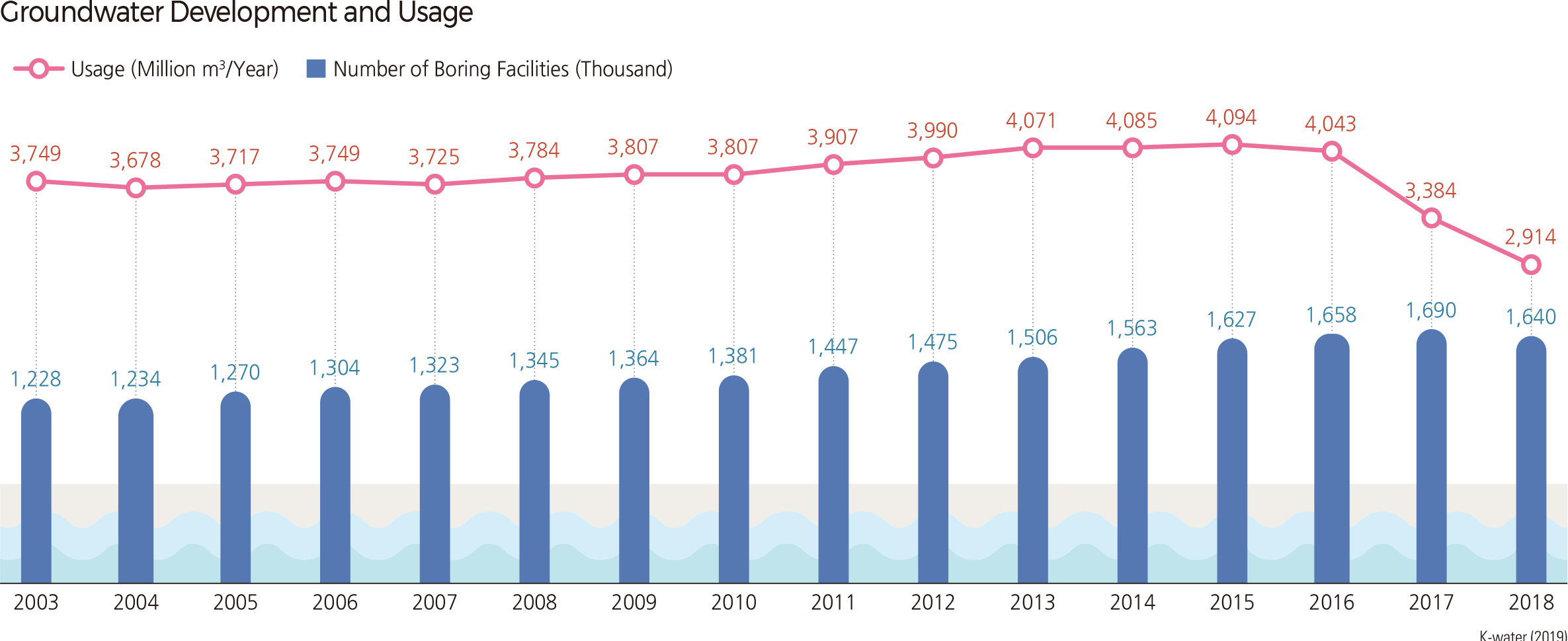
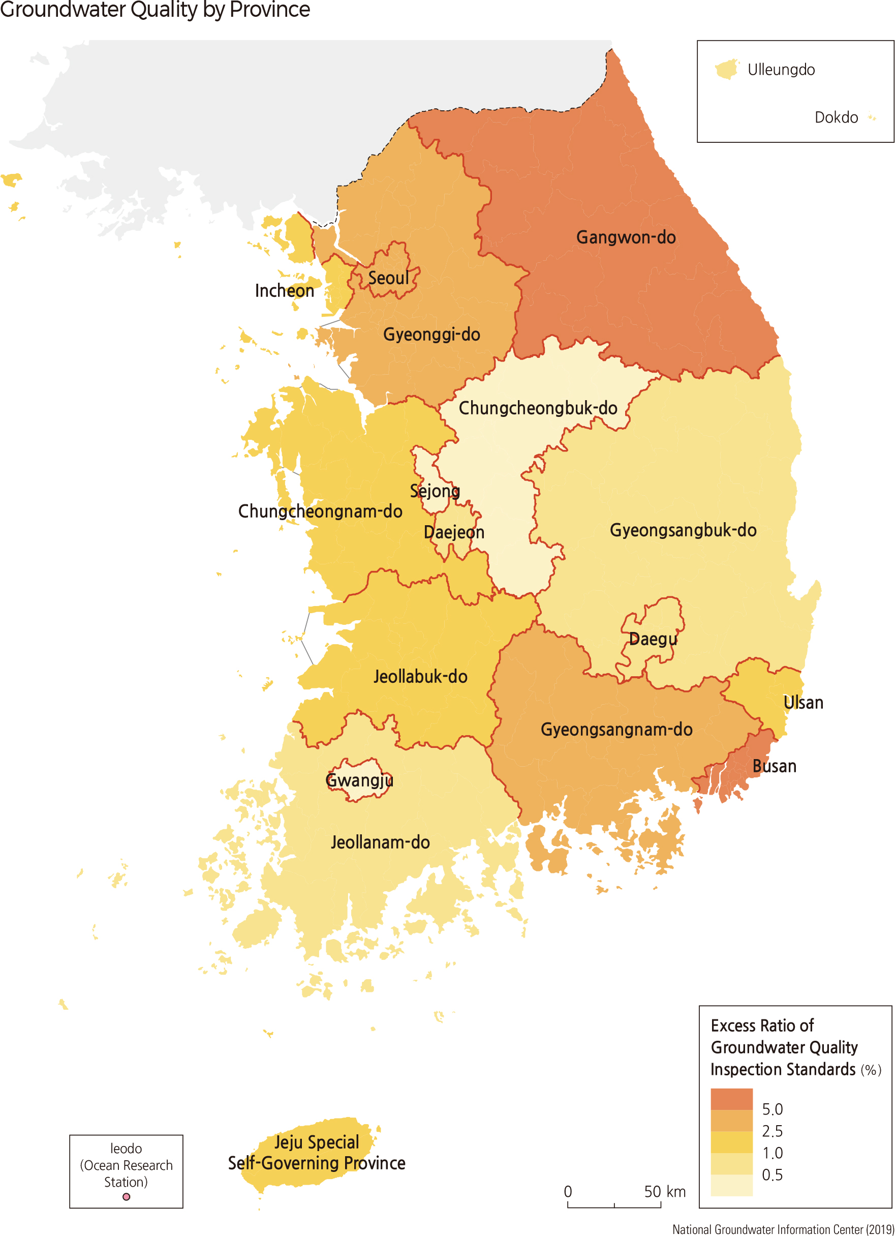
Various plans are required to prevent the projected water shortage across the nation; an integrated supply system for waterworks must be established, existing facilities should be maintained to uphold effective operation, and small reservoirs should be constructed to obtain new water sources. Global climate change may further intensify the water shortage by 1.8–3.5 times by extending droughts and increasing demand for water. As such, it is also necessary to facilitate the capability to cope with such potential extreme water shortages. The development and use of groundwater have been increasing every year due to population growth and industrial development. The amount of groundwater used is decreasing as the supply of tap water has recently increased. As of 2018, the country used 2.9 billion tons of groundwater through approximately 164 million tube wells. Compared to 2003, this is a 34% increase in facilities and a 22% increase in usage.
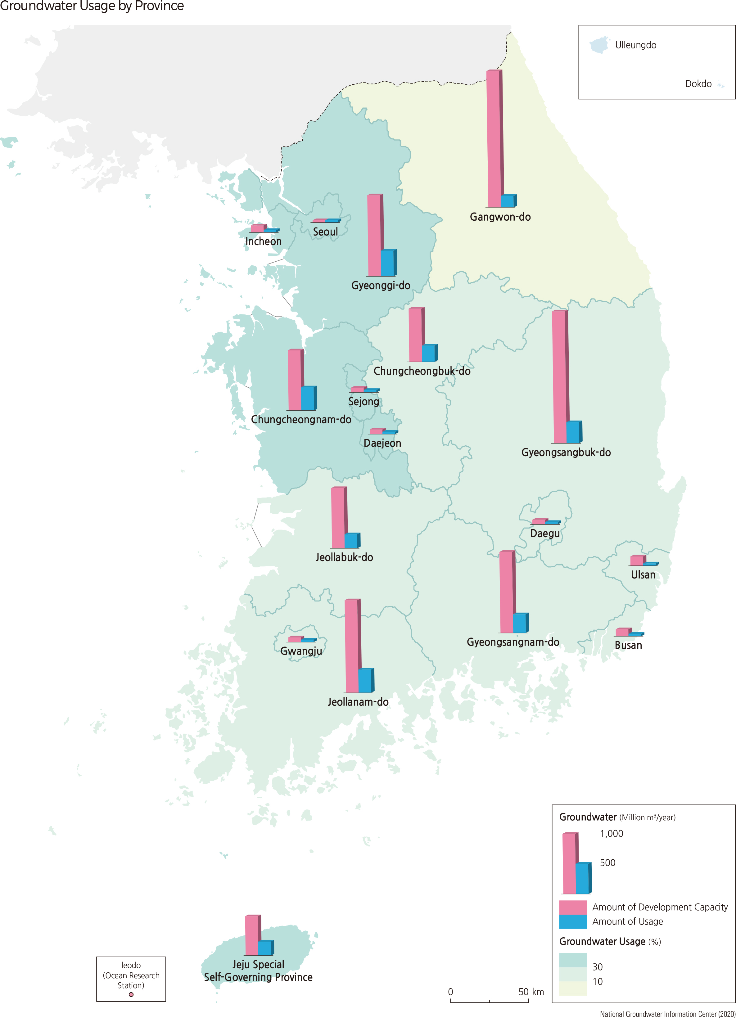
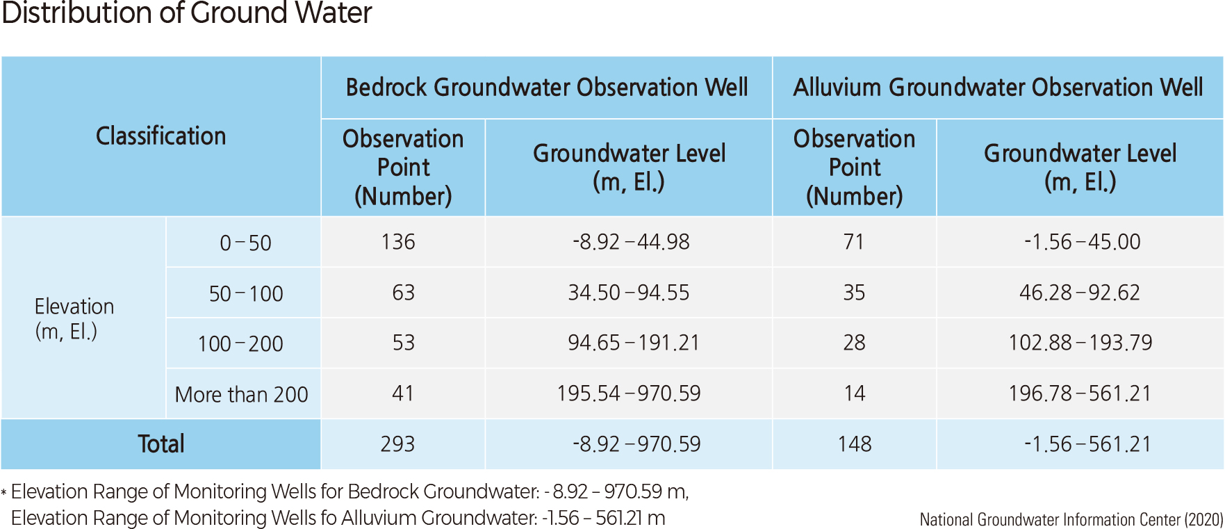
The sustainable development yield of groundwater, which is the largest amount of groundwater that can be used continuously as the inflow and outflow of groundwater are in equilibrium, is about 13 billion ㎥ per year. The volume of groundwater is calculated based on the data collected from the observation network. The annual use of groundwater is about 2.9 billion ㎥, which is about 22% of the sustainable development yield and is equivalent to the storage capacity of 2.9 billion ㎥ of the Soyang Multipurpose Dam. The most common groundwater-related facilities are residential water facilities. As for groundwater use, agricultural water is about 1.48 billion ㎥ per year, followed by residential water (1.23 billion ㎥ per year). About 93% of the annual use of groundwater is for agricultural and domestic water.
By administrative district, Gyeonggi-do accounts for 13.9% (0.406 billion ㎥) of the annual use of groundwater, followed by Jeollanam-do at 12.9% (0.376 billion ㎥) and Chungcheonnam-do at 12.5% (0.364 billion ㎥). Alluvial aquifers are widely distributed around large rivers such as Hangang and Nakdonggang. The total area of these aquifers is 27,390 ㎢, about 27% of South Korean territory. The depth of these aquifers is about 2–30 m, and the production of groundwater is 30–800 ㎥/day per one borehole. The production by region shows a pattern similar to that of Korean terrain, which is high in the east and low in the west. Due to the westward flow of most rivers, there is more recharge in the eastern region and more discharge in the western region.
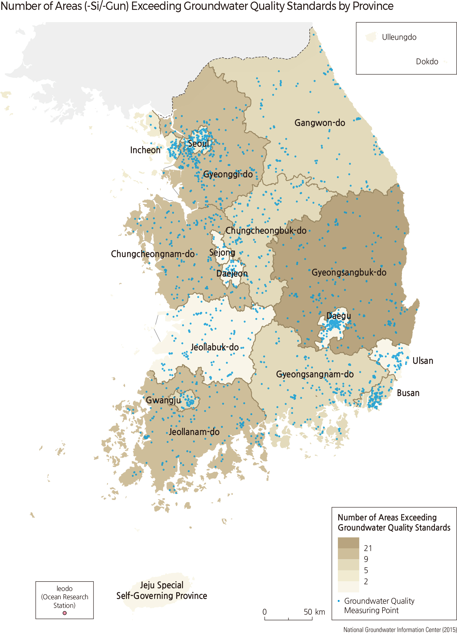
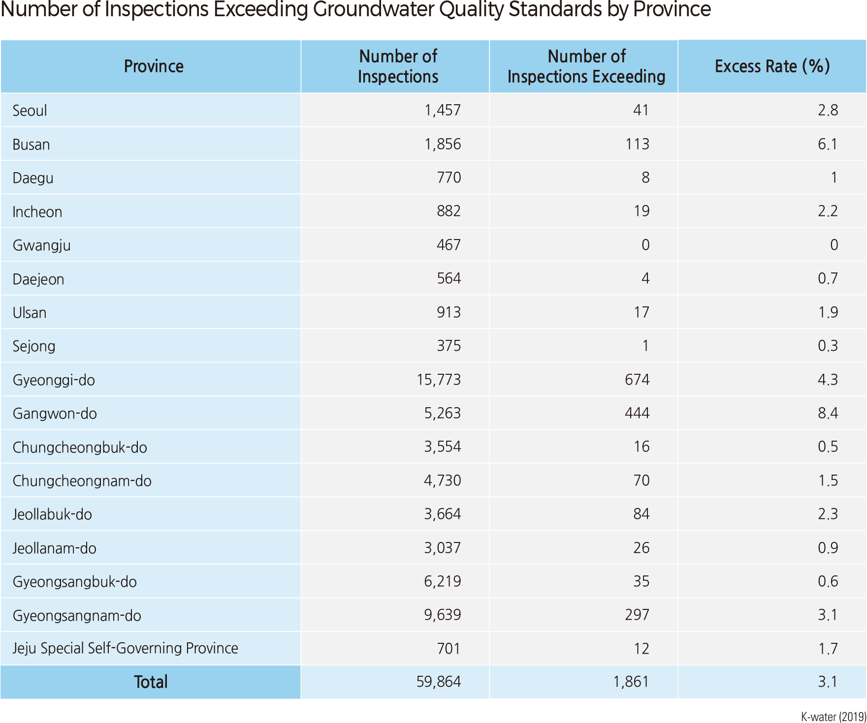
The National Groundwater Monitoring Network regularly monitors groundwater level and water quality. This network aims to prevent groundwater-related problems such as lowering groundwater levels, groundwater source depletion, and groundwater pollution. It also aims to establish a rational development and maintenance plan for the efficient use and management of groundwater resources. The first 15 observatories were installed in 1995, and 442 observatories were installed by 2018. The National Groundwater Monitoring Network observes water level, electrical conductivity, water temperature 24 times a day, and conducts water quality inspections according to groundwater quality standards for residential water twice a year.
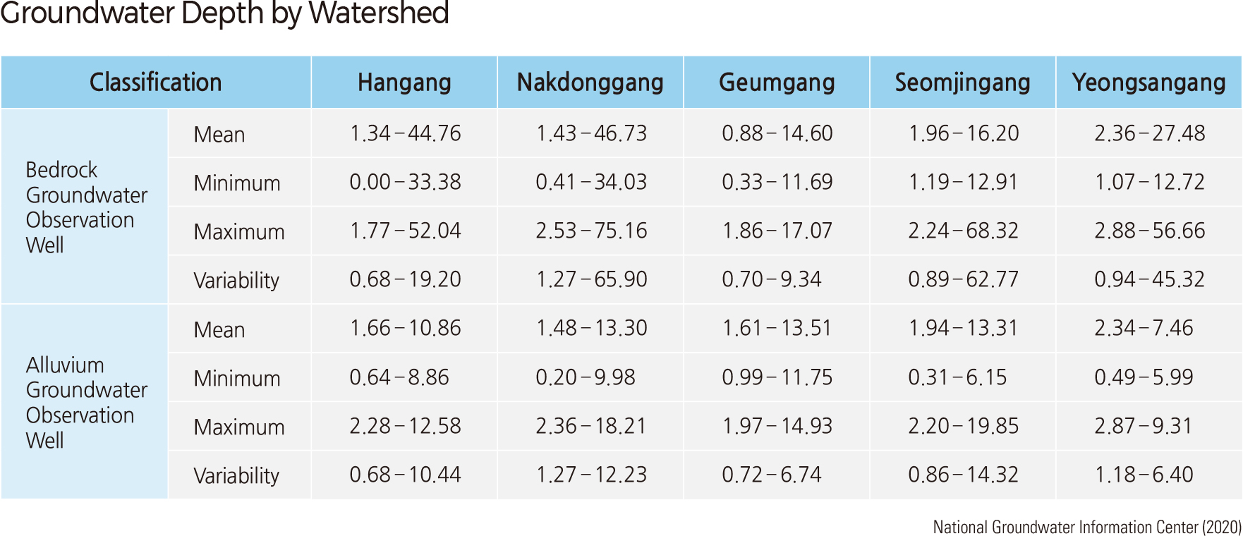
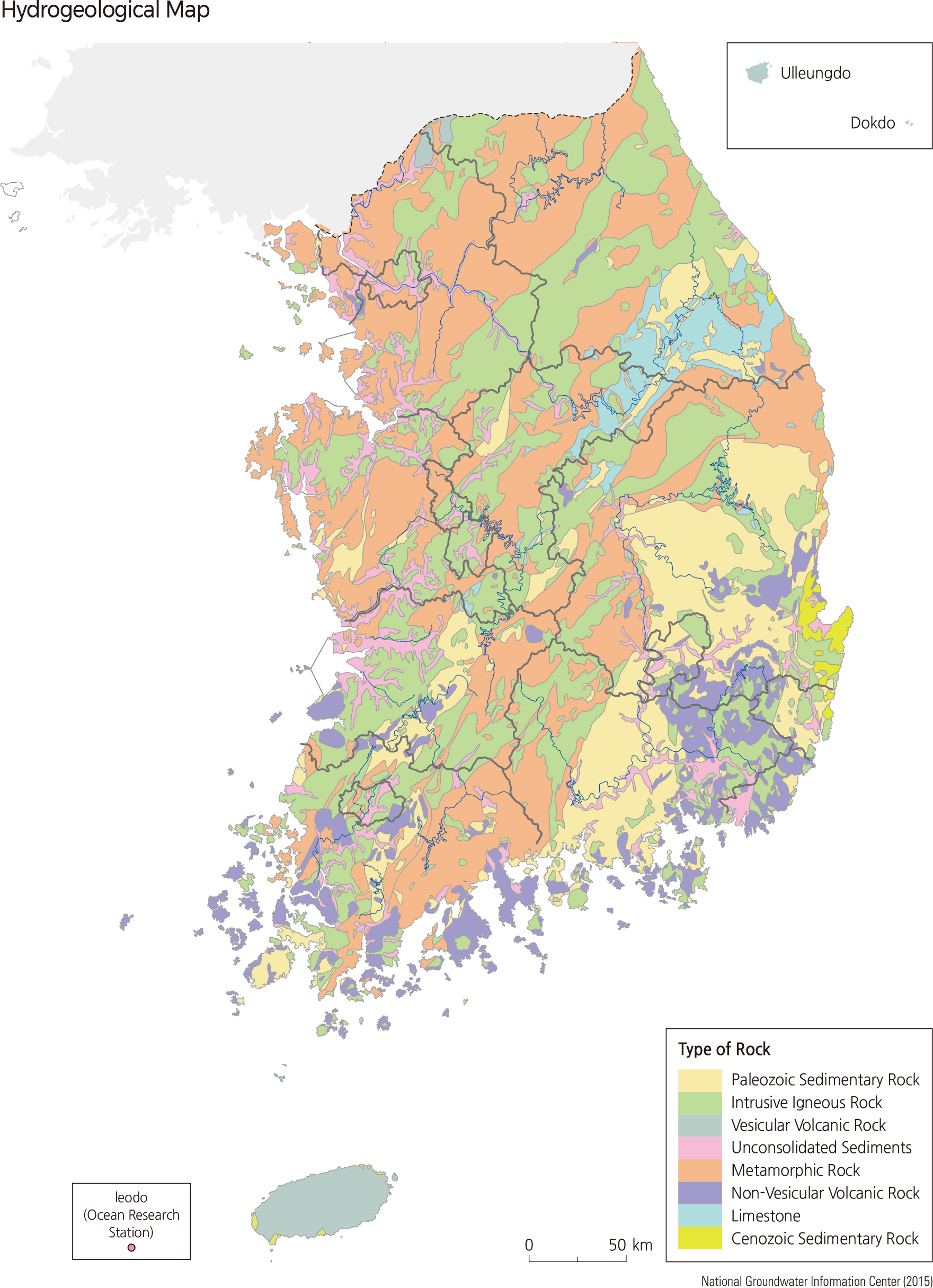
The hydrogeological map is a reclassification that divides alluvial and bedrock aquifers in Korea into eight hydrogeological units by rock configuration (such as type, rock sheet, pore shape, and topography). The geological characteristics of each region largely determine the quality of groundwater.
The Taehwa River estuary and Hyeongsan River estuary on the east coast, which are sedimentary rocks of the Gyeongsang system, generally show better groundwater output than other areas. Gyeonggi-do, Chungcheong-do, and Gyeongsangnam-do, which have a wide distribution of crystalline rocks, have relatively abundant groundwater yields in the lower weathering zone of Jurassic granites. Groundwater yield is also in good condition in upstream Namhangang and in the limestone areas in the eastern part of Korea. Jejudo, composed of porous basalt from volcanic activity, has water resources that consist entirely of groundwater. As such, it also shows good recharge and production rates. |