English II 2020
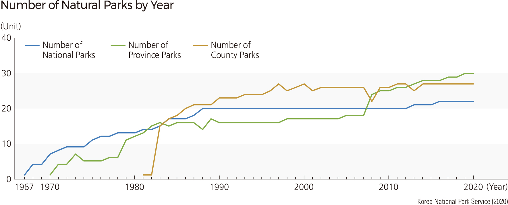
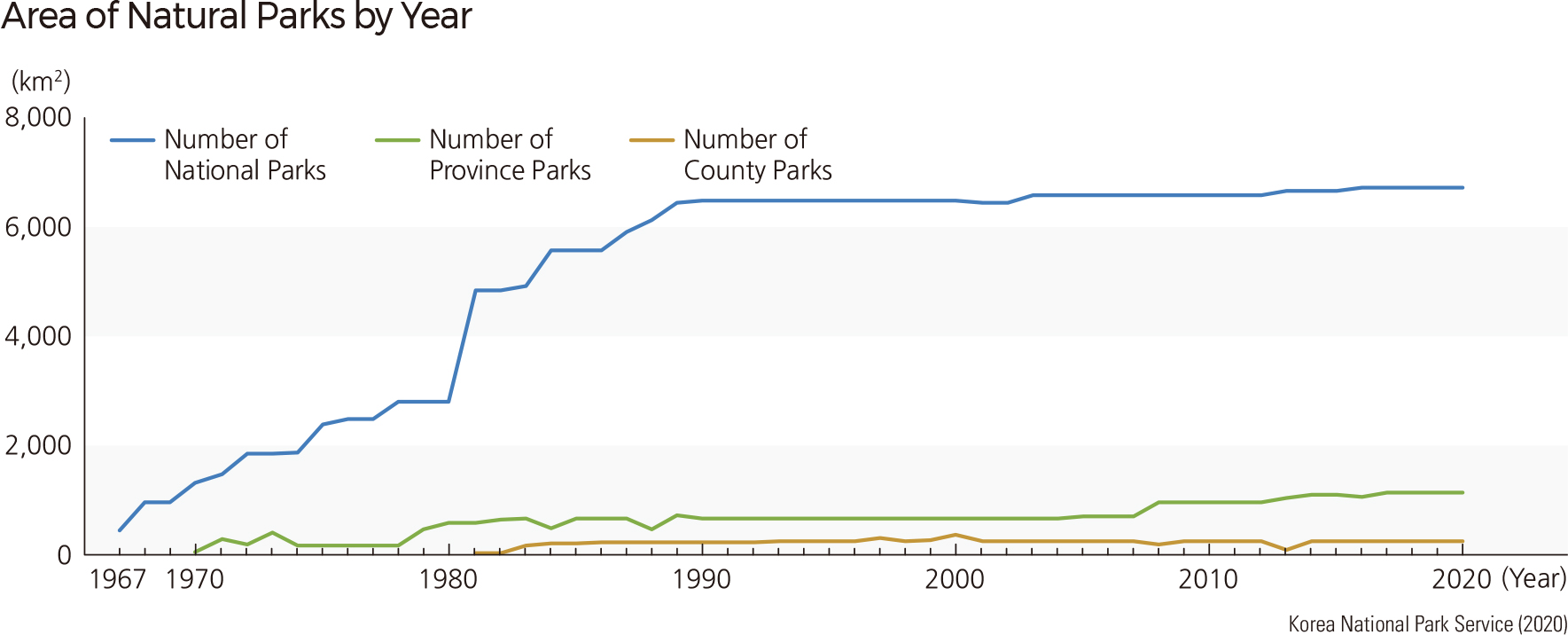
Since the designation of Jirisan National Park as the first national park in Korea on December 29, 1967, a total of twenty-two national parks have been designated and protected. Except for Hallasan National Park, which is managed directly by Jeju Special Self-Governing Province, the National Park Authority (established in 1987) manages all the national parks. The total area of the national parks is 6,726 ㎢, of which 3,973 ㎢ are land, and 2,754 ㎢ are sea. Among the twenty-two national parks, seventeen are associated with mountains, four are coastal, and one, Gyeongju National Park, is urban. Taebaeksan was the last to be designated as a national park on August 22, 2016.
Other than national parks, various regions have been selected and designated as natural parks to protect ecosystems and cultural landscapes. Among these natural parks, some prominent examples include provincial and county parks, as well as ecological landscape conservation areas. Provincial parks are representative areas of natural ecosystems and landscapes in metropolitan cities and provinces. As of 2019, there are thirty provincial parks (total area 1,129 ㎢) that have been designated. County parks are representative of local districts (si and gun) with a total of twenty-seven parks (total area 238 ㎢) currently being operated. Such natural parks increase the value of the natural ecosystems and thereby provide the local community with opportunities for regional development. Lately, the number and area of the provincial and county parks has been increasing as provincial municipalities attempt to promote regional development and tourism.
National Ecological Landscape Conservation Areas are chosen and managed based on their geological-geomorphological value, vegetational importance, ecological recognition, or necessity for conservation. These areas present significant value for conservation and scholarly research on biodiversity by maintaining the integrity of natural ecosystems. The regions possess distinct geological or topographical characteristics that are protected for research and scenic sustenance. They also represent diverse ecosystems and possess exceptional natural landscapes such as rivers, mountains, and valleys. Nine areas are currently designated and protected across the country by the central government, and 24 by local governments.
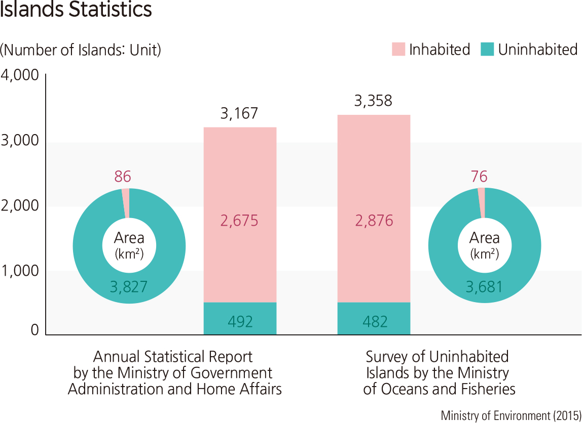
Among Korea’s 3,167 islands, all accessible and large islands are occupied by residents, while 2,675 small, remote islands remain uninhabited. Uninhabited islands are important to national territory and economics, as they are crucial defining base points for national boundaries and exclusive economic zones. From an ecological or environmental perspective, uninhabited islands are protected from human disturbance, so their conservation status is higher than that of inhabited islands. From an academic point of view, uninhabited islands have special geologic, topographic, landscape, and ecosystem features that provide opportunities to investigate changes in climate, land surface features, and sea level. Also, uninhabited islands are more affected by ocean currents and sea waves, thus providing easier observation of various coastal topographic features that result from erosional and depositional processes. Erosional landforms such as wave-cut platforms, sea cliffs, sea caves, sea arches, sea stacks, and notches are predominantly located where the rocky coasts of uninhabited islands meet the open sea. By contrast, islands located in inland seas often have beaches and tidal flats.
Under the Act on the Conservation and Management of Uninhabited Islands established in 1997, conservation efforts have been carried out for uninhabited islands with particular landscape value or ecological importance. As of 2018, 1,360 islands have been investigated. As of 2020, 257 islands are registered as special islands for conservation. These special islands are mainly located in Jeollanam-do and Gyeongsangnam-do, as coastlines with long, narrow inlets are very prominent in these regions.
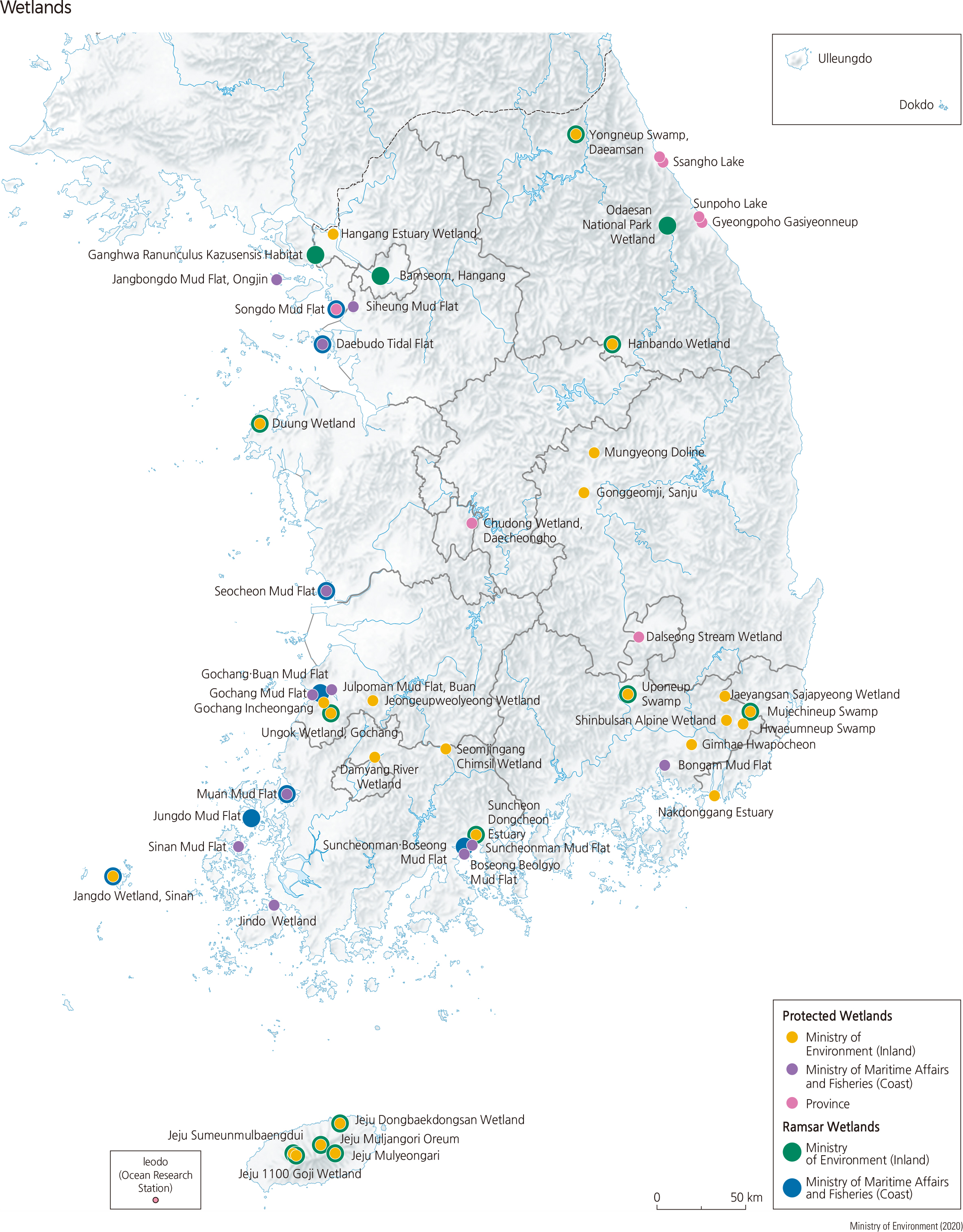
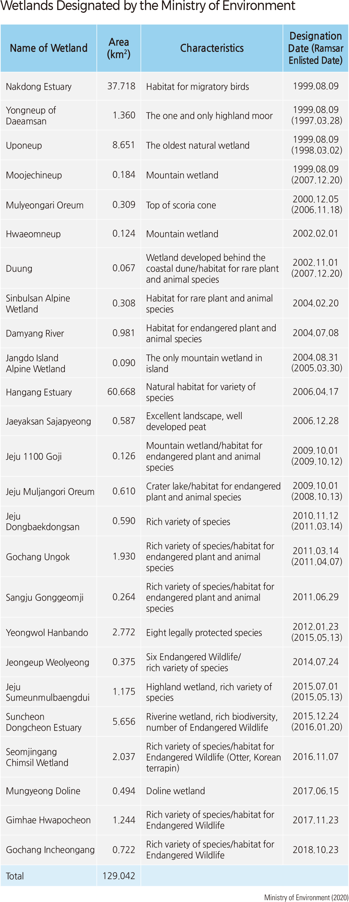
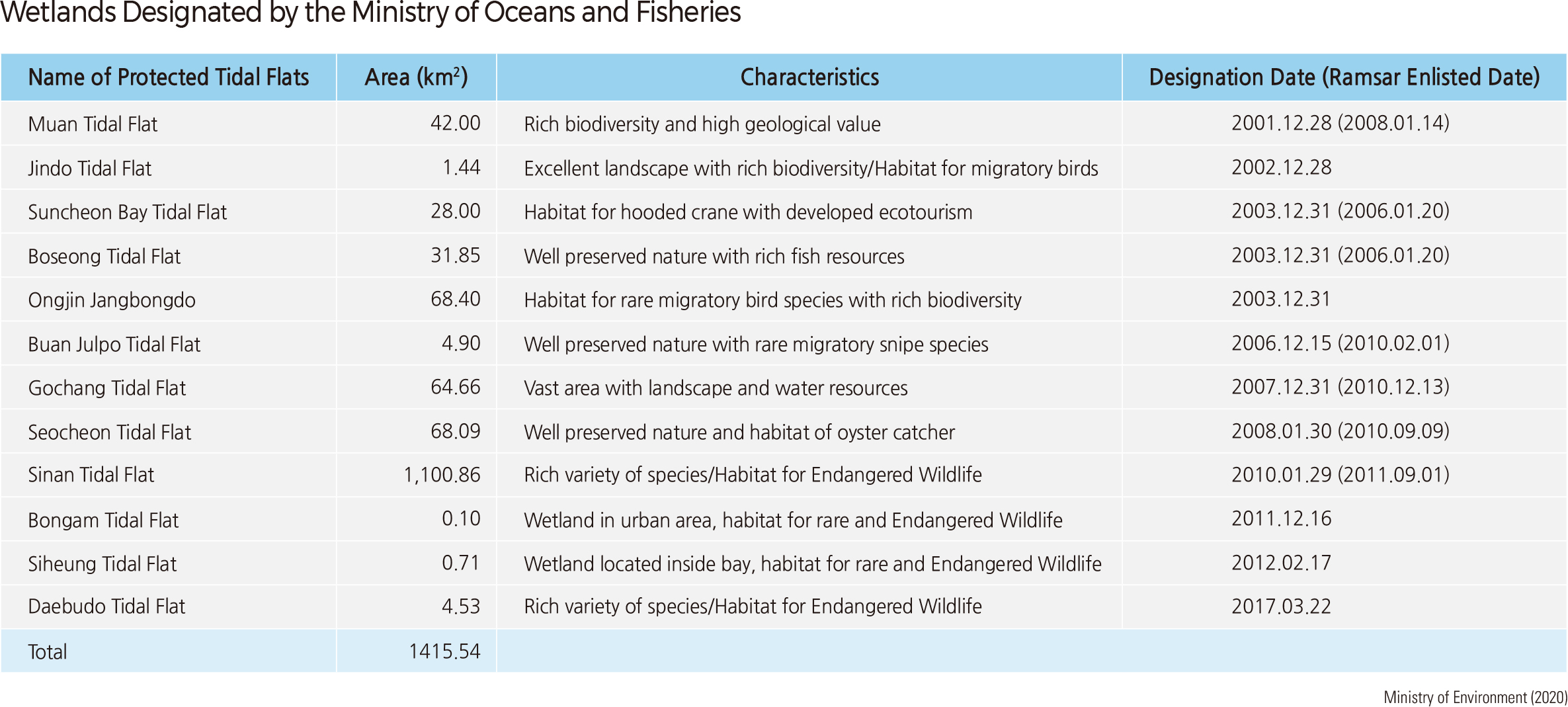
Wetlands are a haven for biodiversity and provide an ecological buffer zone for hydrological and atmospheric processes. Korea has been using wetland monitoring to select certain wetlands as subjects for its conservation plans. Currently, 25 protected wetlands (total area of 129 ㎢) have been designated by the Ministry of Environment: 12 along the seaside (1,416 ㎢) by the Ministry of Ocean and Fisheries, and seven (8.3 ㎢) by provinces. The Convention on Wetlands of International Importance (the Ramsar Convention) took place in Ramsar, Iran in 1971 and was enacted in 1975. It was intended to protect internationally important wetlands that function as habitats for animal and plant wildlife— waterfowl in particular. As of 2019, 171 countries have joined the Convention, and Korea has been a member since 1997. Twenty-three registered wetlands in Korea are recognized by the Ramsar Convention, including Gangwon-do Daeamsan Yongneup Swamp, Changnyeong Uponeup Swamp, Jangdo Wetland and Suncheonman in Jeollanam-do, Chungnam Taean Duung Wetland, Ulsan Mujechi Wetland, Muan Tidal Flat, Ganghwa Maehwamareum Habitat, Odaesan Wetland, Yeongwol Hanbando Wetland, and Mulyeongari, Muljangori Oreum, and Sumeunmulbaengdui in Jejudo.
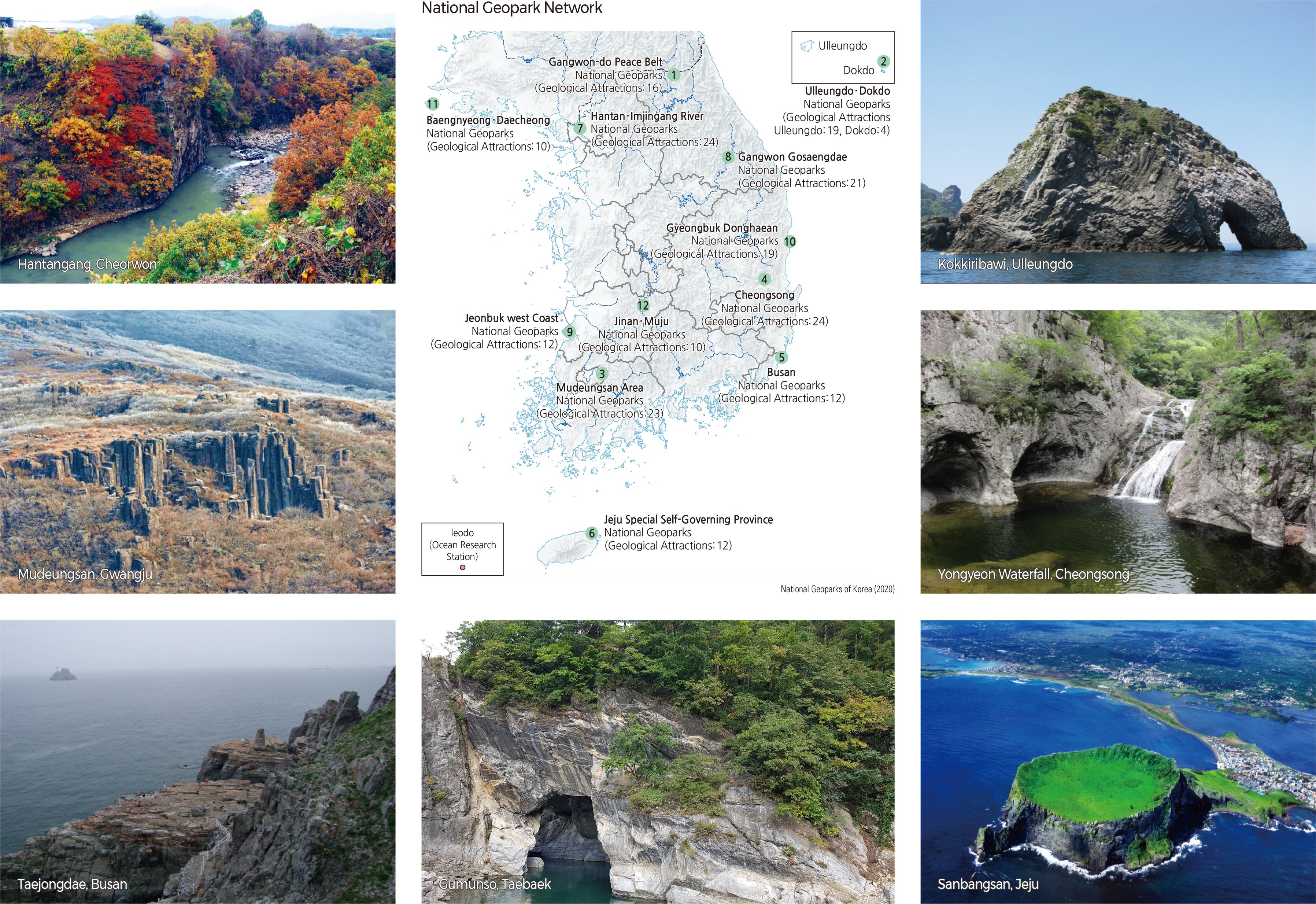
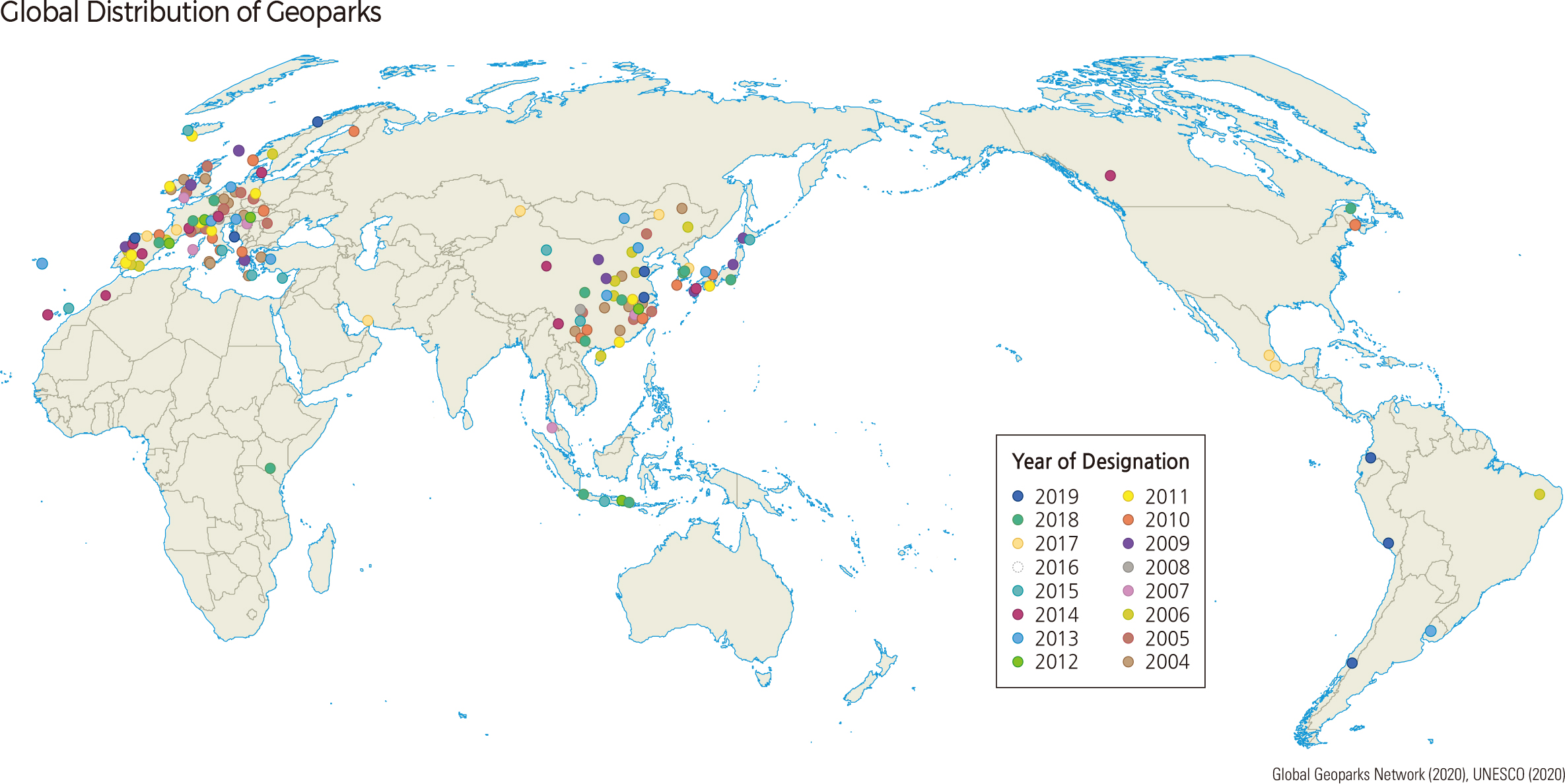
National Geoparks target areas with geological and geomor-phological significance to carry out conservation activities that meet the criteria prescribed in a particular country (in the case of Korea, the Ministry of Environment certification). National and World Geoparks are almost identical in their assessment and certification procedures, management structures, and operating systems. As of 2020, Korea operates 12 National Geoparks: Jejudo, Ulleungdo ∙ Dokdo, Busan, Gangwon Peace Geopark, Cheongsong-gun, Mudeungsan, and Hantangang ∙ Imjingang. Many more candidates are waiting to be designated.
The whole of Jejudo, with its diverse volcanic landforms and geological resources, is a National and International Geopark. As the first National Geopark of Korea, Jejudo is often referred to as a “Museum of volcanoes” as it boasts a variety of unique volcanic landforms. There are about 360 cinder cones above the surface and about 160 lava tubes and caves that are located underground. It is a rare phenomenon to see so many volcanic features including underground tubes on one small island.
Ulleungdo and Dokdo are volcanic islands that provide essential clues explaining the formation of the East Sea. They are very important in various research fields, including geology, biology, oceanography, and history. Seonginbong (986.7 m)—the highest peak of Ulleungdo—is located at the center of the island. Ulleungdo also has the Nari Basin, formed by a depressed caldera, and small peaks called Albong. Some other geosites of Ulleungdo and Dokdo include Dodong and Jeodong Beach with well-developed sea cliffs and wave-cut platforms, Gooksu Rock with its columnar joints, Daepoonggam, Elephant Rock, Turtle Rock, Bongrae Waterfall, Songgot Peak, Seonginbong Primitive Forest, and Mongdol Beach. On these two tiny islands, there is a total of 23 geosites.
Busan has a variety of diverse landscape features such as coasts, mountains, and estuaries. Consequently, it has a rich geo-heritage and a wealth of cultural assets. Nakdong Estuary, Songdo Peninsula, Taejongdae, Oryukdo-Igidae, Changsan, and Geumjeongsan are some of the 12 geosites in Busan.
Gangwon Peace Geopark was designated to transform the areas around the DMZ from a symbol of Cold War hostility to a symbol of peace. It contains a rich geological and geomorphological heritage and spans across Cheorwon-gun, Hwacheon-gun, Yanggugun, Inje-gun, and Goseong-gun. There are 16 geosites, including the Cheorwon Lava Plateau, Haean Basin (Punch Bowl), and Potholes of Naerincheon.
Cheongsong Geopark is famous for its magnificent landscape and plenty of historical, cultural, ecological, and archaeological heritage sites. Among 24 geosites, major locations include Yongchu Waterfall, Jeolgu Waterfall, Yongyeon Waterfall, Dalgi Waterfall, Juwang Cave, and Cheongsong Ice Valley.
Mudeungsan Area Geopark is located in Gwangju, Hwasun-gun, and Damyang-gun. It has 23 geosites such as the Seosokdae Columns and the Seoyuri Dinosaur Fossil Site, and 42 cultural heritage sites such as Mujin Goseong and Unjusa Temple.
Hantangang ∙ Imjingang Geopark includes Jaein Waterfall and Jwasang Rock of the Mesozoic, Jeogbyeok Columnar Joint, Dangpo Castle, Yeoncheon Jeongok-ri Prehistoric Site, Baegeui-ri Sedimentary Layer, Dongmak-ri Tuff, Pillow Lava in Auraji of Yeoncheon, Hwajeokyoun Pond, Art Valley, and Gurai Valley in Pocheon-si. It has 24 geosites overall.
Gangwon Gosaengdae is located in Taebaek-si, Yeongwol-gun, Jeongseon-gun, and Pyeongchang-gun, Gangwon-do. It includes rock- and fossil-related geosites, such as stromatolites; Jurassic conglomerate and Gumunso Pond; karst-related geosites, such as Gossi Cave and Hwaam Cave; and river- and wetland-related geosites, such as Yoseonam Pothole and Cheongryeongpo, with a total of 21 geosites. The west coast of Jeollabuk-do, located in Gochang-gun and Buan-gun, has 12 geosites, such as Myeongsasipri, Gusipo, Soyosan, Chaseokgang, Jeokbyeokgang, and Jikso Waterfall.
Gyeongsangbuk-do Donghaean is located in Uljin-gun, Yeongdeok-gun, Pohang-si, and Gyeongju-si along the East coast and has 19 geosites, including Deokgu Valley and Seokryu Cave in Uljin-gun; Goraebul Beach and Jukdosan sedimentary rock in Yeongdeok-gun; Daljeonri columnar joint in Pohang-si; and Yangnam columnar joint in Gyeongju-si.
Baengnyeong and Daecheong include Baengnyeongdo, Daecheongdo, and Socheongdo. Geosites in Baengnyeongdo are Dumujin and Sagot Beach. Geosites, such as Okjukdong Coastal Dune, Geomeunnang, and stromatolites, are located in Daecheongdo and Socheongdo.
10 geosites are located in Jinan-gun and Muju-gun, Jeollabuk-do, such as Osanri orbicular granitic gneiss, UnilamBanilam, Yongchu Waterfall, and Jeoksangsan Cheonil Waterfall. |