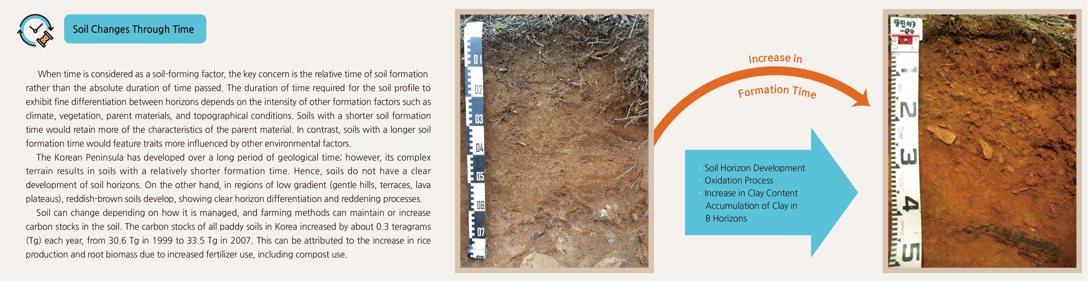
English II 2020
Climatic factors, especially precipitation and temperature, have the biggest influence on the formation of soil. The Korean Peninsula has a temperate monsoonal climate with four distinct seasons of spring, summer, autumn, and winter. Heavy rainfall occurs during July and August, which causes slopes to have shallow soil due to soil loss. Summer has an average temperature of approximately 20˚C–25˚C, with August being the hottest month, while winter has an average temperate of -5˚C–5˚C, with January being the coldest month.
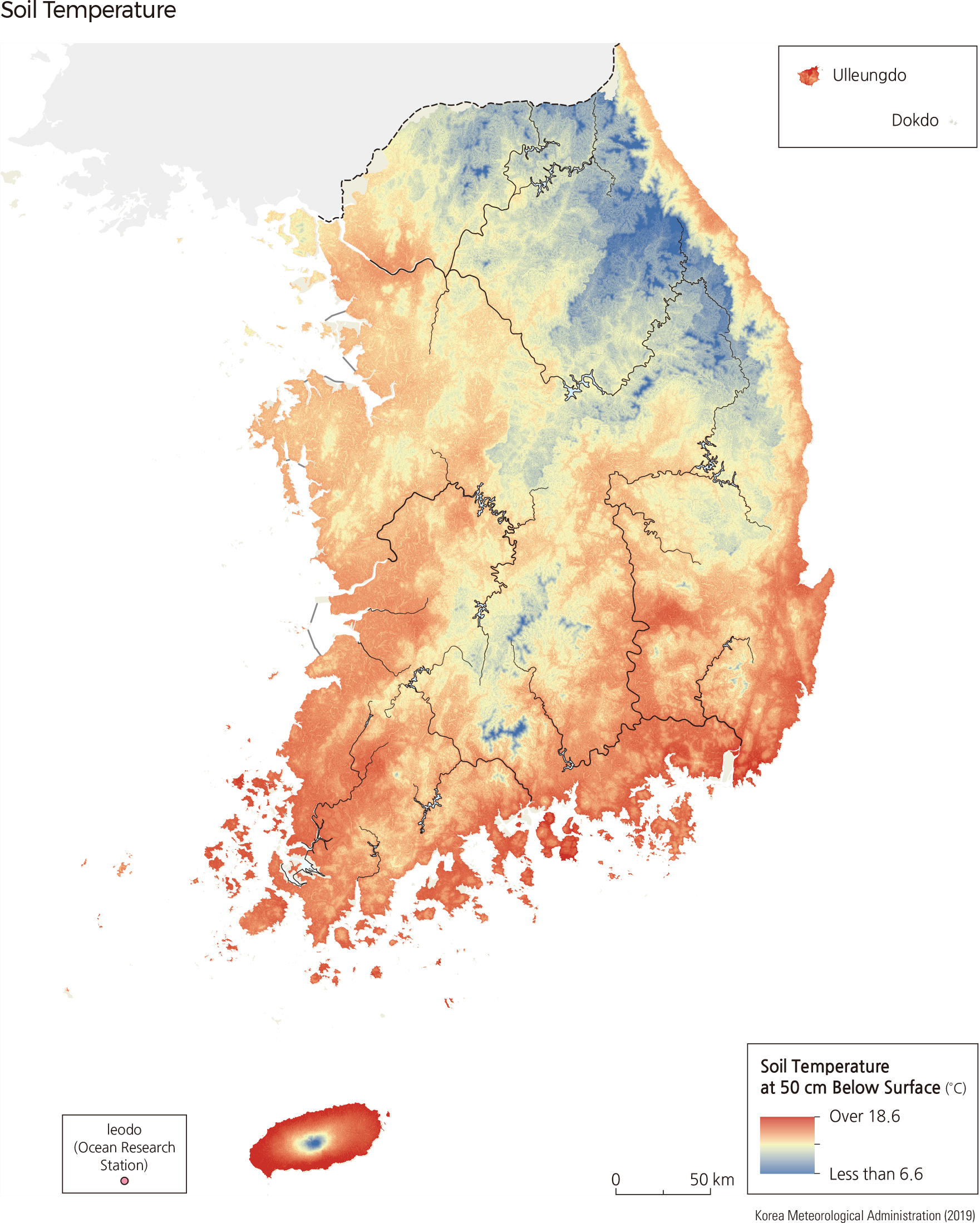
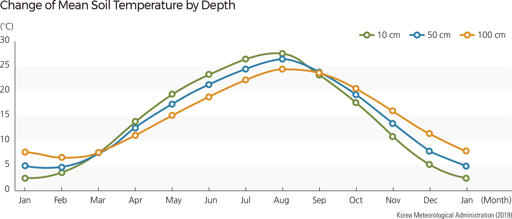
The mean annual soil temperature in Korea is 14.5˚C, ranging from 7.1˚C in Daegwallyeong to 18.1˚C in Seogwipo. According to the soil temperature regimes, Korean soils mostly belong to the mesic (8˚C–15˚C) or thermic (15˚C–22˚C) regime. The Korean mean annual soil temperature at 10 cm of soil depth (which is highly relevant to underground plant growth) is reported to be 1.6˚C lower than the mean atmospheric temperature. This difference varies in the summer (1.9˚C in August) and winter (1.8˚C in January), and also ranges from 0.9˚C in March to 2.2˚C in September. The difference is more significant during summer and autumn than it is during spring.
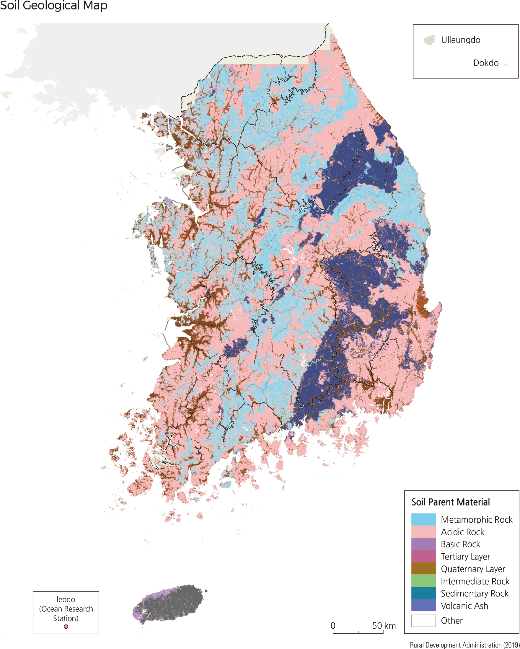
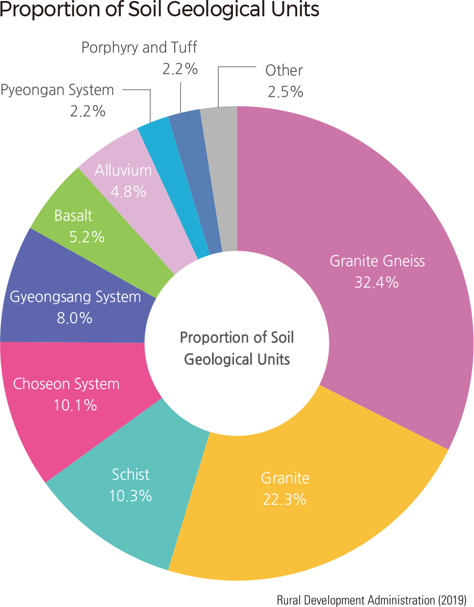
Korea has many diverse soil types. A total of 405 series of soils are developed from different parent materials. Soils originating from granite, granite gneiss, and granitic gneiss are coarse and shallow due to intensive soil erosion on steep, high mountain faces. Soils originating from schist and gneiss are acidic. Limestone is widespread throughout some areas in Gangwon-do, northern Gyeongsangbuk-do, and northern Chungcheongbuk-do. Soils from limestone have shallow soil depth and are usually fine-textured and slightly acid or neutral.
The Gyeongsang Supergroup is a repre-sentative sedimentary rock layer that is distributed in Gyeongsang-do. Within this supergroup, there are two subordinates: the Nakdong group and the Silla group. The rocks in the Nakdong group are mostly shale, sandstone, or conglomerate. Soils from shale often have a deep, well-developed profile. Soils from sandstone or conglomerate are coarse and bright in color. The rocks in the Silla group are andesite, basalt, rhyolite, and tuff. Soils from these rocks are fine-textured and have a deep, well-developed soil profile. Rocks from the Tertiary consist of unconsolidated sandstone, shale, and conglomerate and are common in Gyeongsangnam-do and Gyeongsangbuk-do. Soils from sandstone are coarse and bright, while those from shale are medium-textured and have a shallow soil profile. Basalt is most commonly located in Jejudo, and soils developed from basalt are dark brown, fine-textured with average depth. Soils from volcanic ash are very dark brown or black due to their high organic material content.
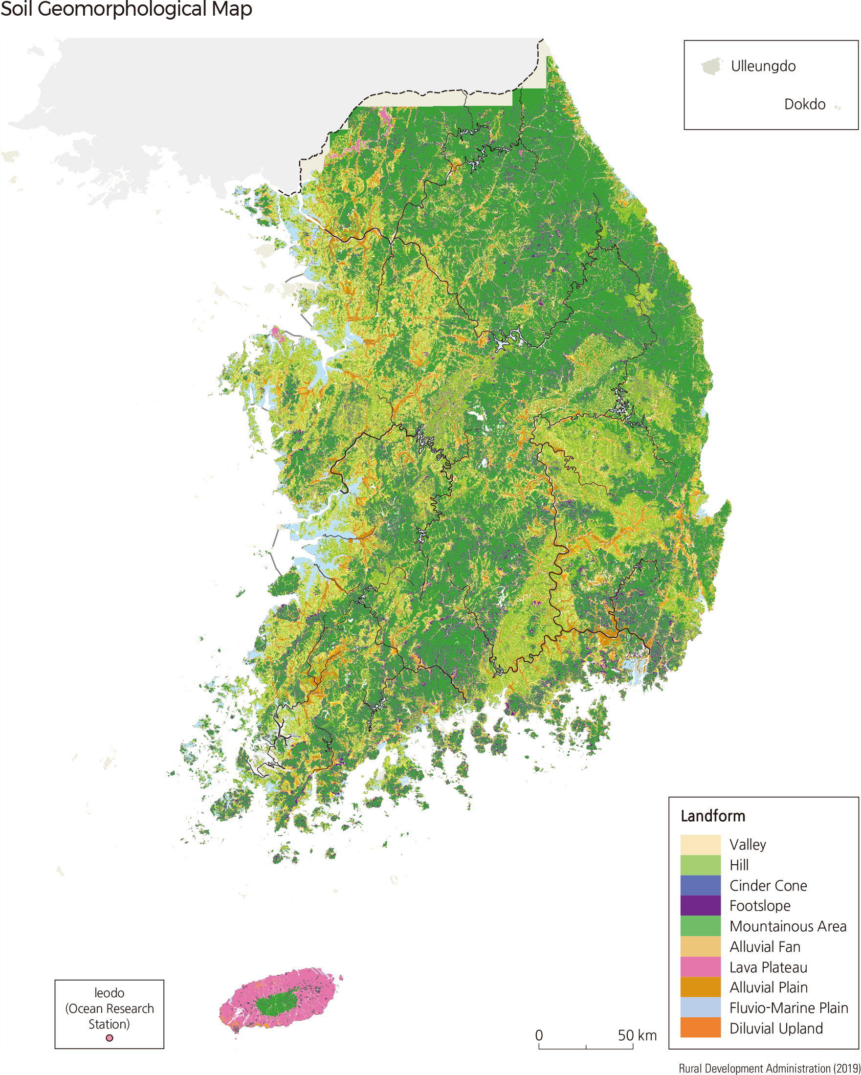
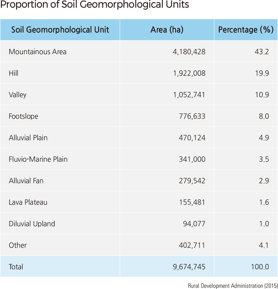
As the climatic pattern of Korea shows little difference between regions, topographic factors play critical roles in soil-forming processes. Consequently, the soil survey system classifies different landforms into ten soil geomorphological units, according to slope gradient and cause of formation.
Among the ten units, mountainous areas constitute the highest proportion, with 43.2% of the total land area. These areas are generally used as forest land as they have shallow soil layers resulting from erosion. Hills take up approximately 19.9% of land area and are mostly located in western coastal areas or granite erosion basins. Although hills have better-developed soil than mountainous areas, they are also used for forests due to the high slope gradient. Valleys (10.9%) are commonly filled with mountain sediments and thus possessing a deeper soil layer. As they usually have convenient access to water sources, valleys are often utilized for small-scale paddies. Foothills (8.0%) are more suitable for farmland than for paddies as they lack a water source. Alluvial plains (4.9%) and fluvio-marine plains (3.5%) are formed by river deposits and joint action of the sea and river, respectively. They are adequate for agriculture usage as they have deep soil layers with high productivity. Other landforms—alluvial fans, lava plateaus, diluvial uplands—each constitute less than 3% of the total land area.
Organisms (animals, plants, and microorganisms) influence the soil-forming processes. Vegetation determines the amount of organic matter supplied to the soil. In grasslands, a lot of organic matter is generated from the decomposition of roots, so the soil becomes black, its moisture content increases, and its cation exchange capacity is improved. One of the most distinctive features of a forest ecosystem, the forest floor, develops from vegetation shed from the canopy and surrounding plant life. The type and content of inorganic components in natural vegetation also affect soil formation. Because conifers are low in alkaline minerals like calcium, magnesium, and potassium, the soil formed under coniferous forests is more acidic than under broad-leaved forests.
Animals change the soil by breaking down organic matter and mixing or moving the soil. In particular, earthworms develop and stabilize the soil's structure and improve the ventilation and drainage of the soil. Earthworm castings, high in nitrogen, phosphorous, and potassium, fertilize the soil. Microorganisms decompose organic matter, change the chemical form of various nutrients necessary for plants, and affect the growth of plants, which in turn affect the soil. |