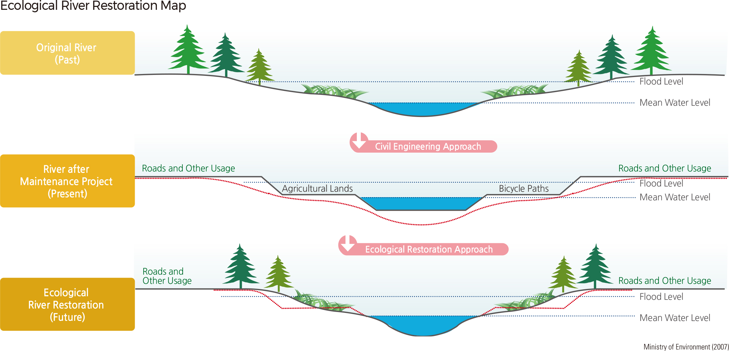
English II 2020
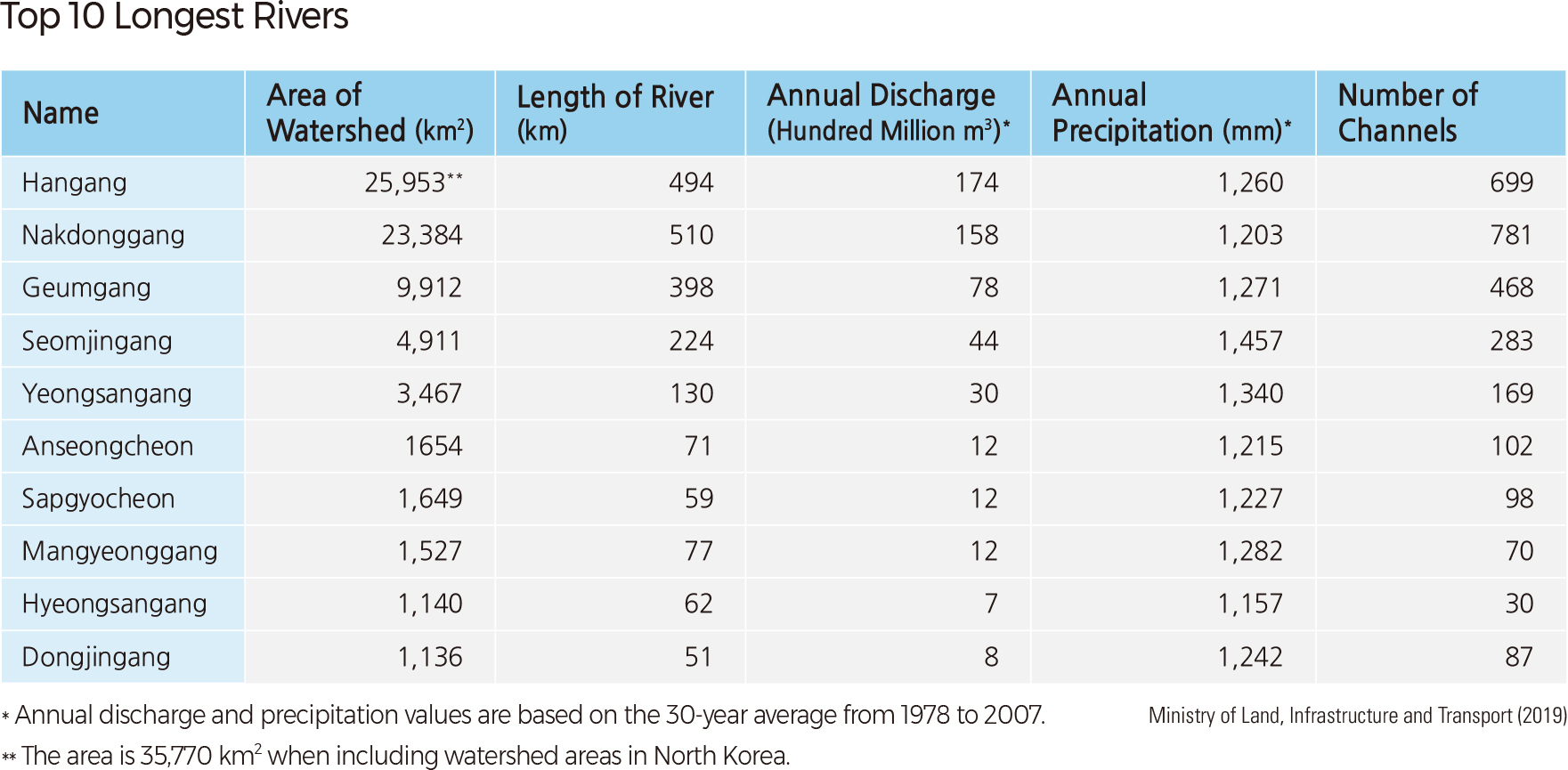
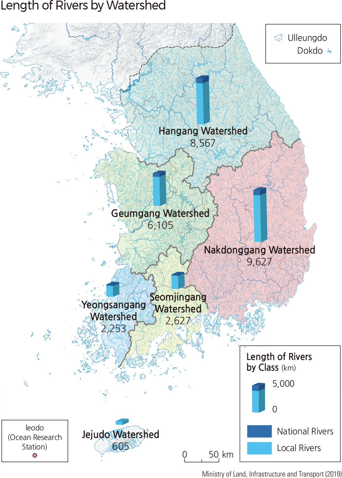
Based on watershed area, the 10 largest rivers in South Korea are Hangang, Nakdonggang, Geumgang, Seomjingang, Yeongsangang, Anseongcheon, Sapgyocheon, Mangyeonggang, Hyeongsangang, and Dongjingang. The Hangang watershed is the largest in terms of area and volume; it has a drainage area of 25,953 ㎢ and a volume of 17.4 billion ㎥. Nakdonggang is the longest river, with a length of 510 km. The Seomjingang watershed has the highest average precipitation of 1,457 mm, while the Hyeongsangang watershed has the lowest annual precipitation of 1,157 mm.
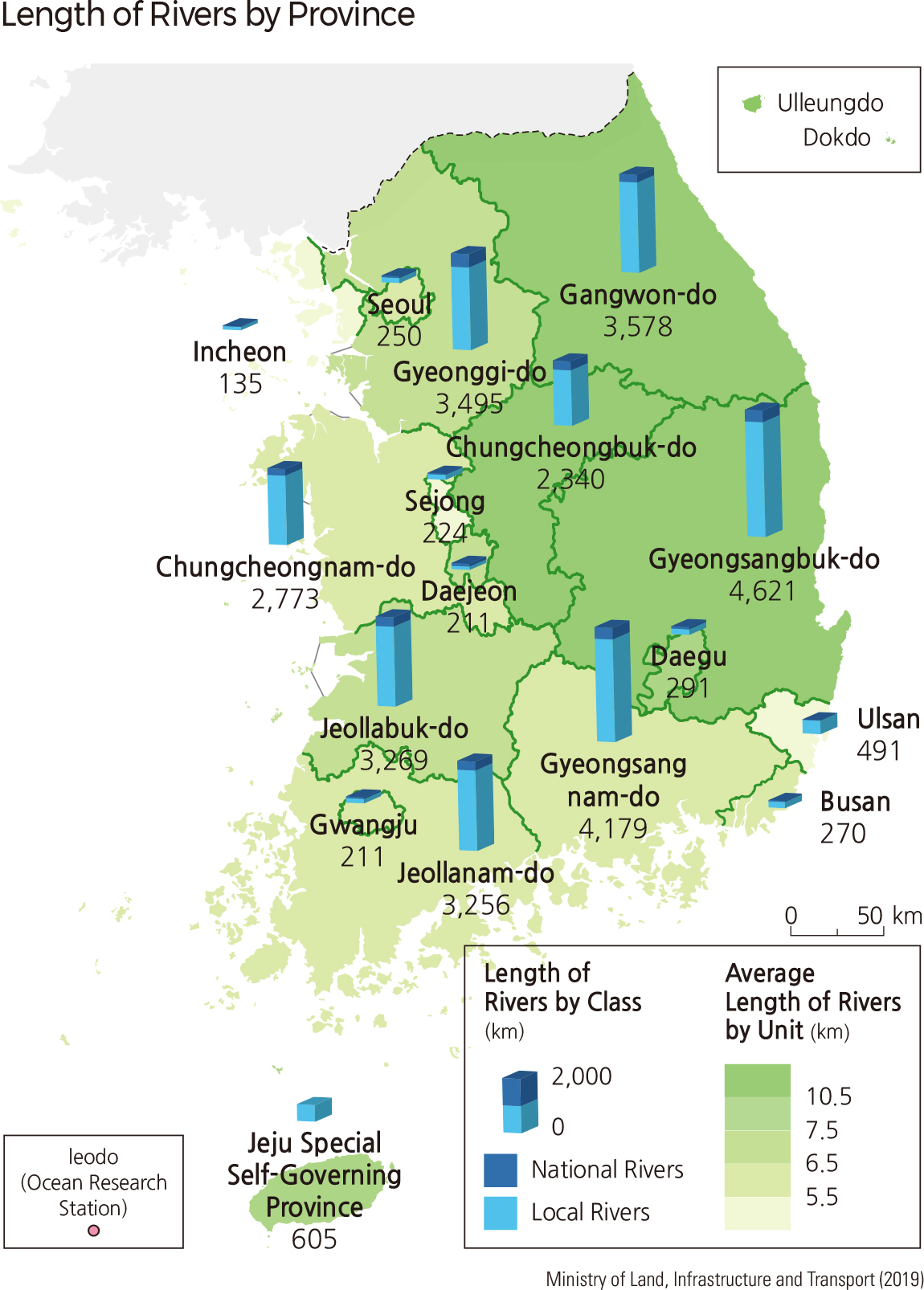
Rivers in Korea are divided into two categories: legally designated rivers and small rivers. Legally designated rivers encompass both national and local rivers, while the Small River Maintenance Act designates small rivers. National rivers are relatively larger bodies (drainage area greater than 200 ㎢) that are important for environmental conservation and the economy of the country. Some examples include upper stream rivers affected by drainage from reservoirs, lower stream rivers located downstream from multipurpose dams, and rivers that flow through densely populated or protected areas. Local rivers are often relevant with public use and are managed by regional governments.
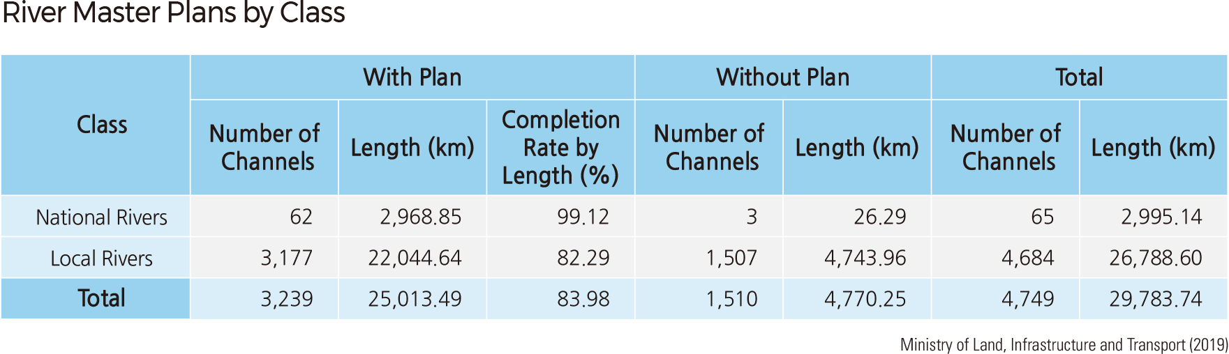
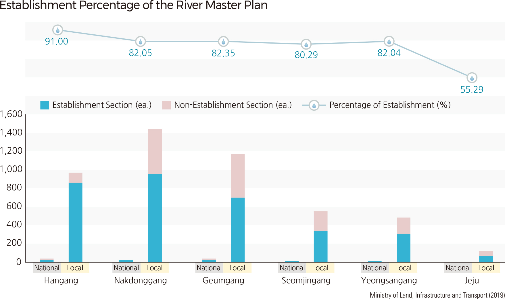
The River Master Plan is a comprehensive river maintenance, conservation, and utilization plan for the functional sustenance and prevention of natural disasters in river systems. Based on the analysis of weather conditions, terrain, and the social and natural environment of each watershed, each plan is imple-mented and revised every 10 years to preserve and manage rivers systematically. As of December 2015, the River Master Plan has been established for approximately 84.0% (25,013.5 km) of all rivers in Korea: 99.1% (2,968.9 km) of national rivers and 82.3% (22,044.6 km) of local rivers. By administrative district, Seoul, Incheon, and Daegu each showed a 100% establishment rate, while Jeju Special Self-Governing Province (61.4%), Gyeongsangbuk-do (73.7%), and Jeollabuk-do (77.4%) showed lower establishment rates.
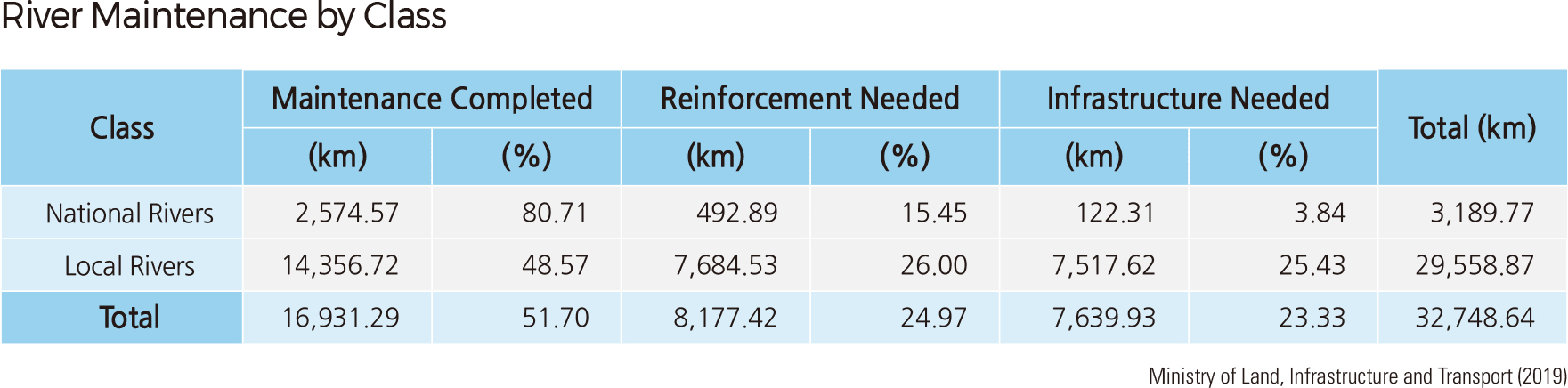
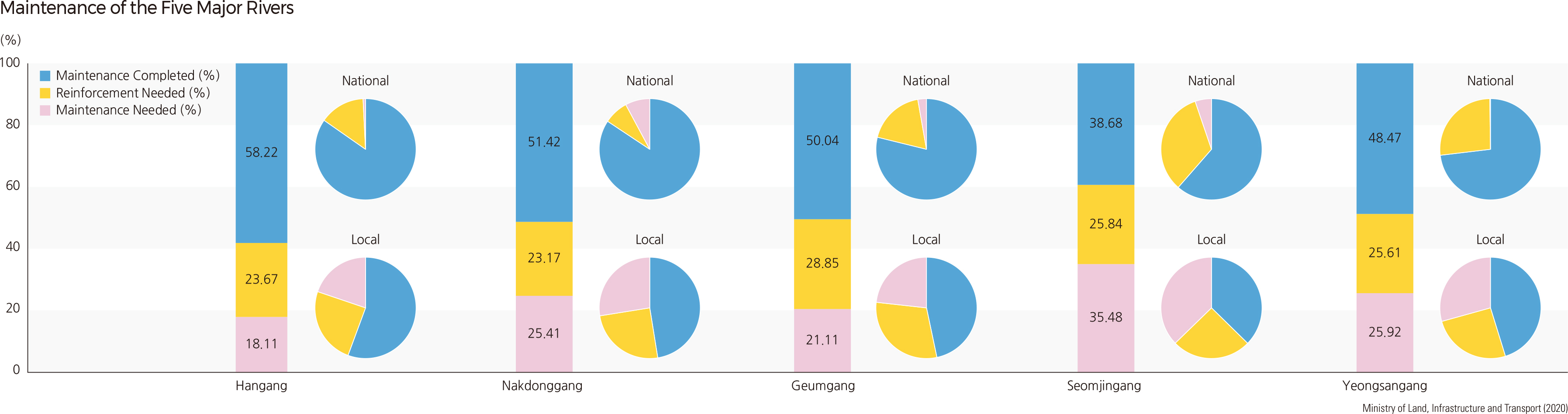
Based on the River Master Plans, river banks are reinforced to prevent flooding by calculating the area of cross-section depending on flood discharge standards for each river. By December 2014, river bank reinforcement had been completed on 51.7% of the total length of legally designated rivers: 80.7% of the total length of national rivers and 48.6% of the total length of local rivers. About 24.9% of the total length of legally designated rivers still need to be reinforced: 15.5% of the total length of national rivers and 25.9% of the total length of local rivers. About 23.3% of the total length of legally designated rivers is required to build new river banks: 3.8% of the total length of national rivers and 25.4% of the total length of local rivers.
Among the five major rivers, Hangang has the highest percentage of reinforced river bank sections at 58.2%, followed by Nakdonggang at 51.4%, while Seomjingang comes last (38.7%). Geumgang has the highest percentage of river bank sections needing reinforcement (28.9%), while Nakdonggang has the lowest (23.2%). Seomjingang has the highest percentage of river sections that need to build new river banks (35.5%), while Hangang has the lowest (18.1%).
By municipal district, Seoul has the highest percentage of stabilized river bank sections at 95.8%, followed by Gwangju (87.1%) and Daegu (76.3%). Sejong shows the highest percentage of river bank sections that need reinforcement (34.4%), followed by Chungcheongnam-do (30.8%) and Jeollabuk-do (29.2%). Districts with the highest percentage of river sections that need to build new river banks are Incheon (45.6%), Jeollanam-do (32.2%), and Jeju Special Self-Governing Province (31.5%).
In terms of small-scale rivers, there are a total of 22,823 rivers, with 43.1% of the total length of their river banks now stabilized. Daegu has the highest percentage of river bank stabilization at 67.5%, followed by Daejeon (60.1%), Gwangju (60.1%), and Seoul (54.1%), while Jeju Special Self-Governing Province comes last (20.9%).
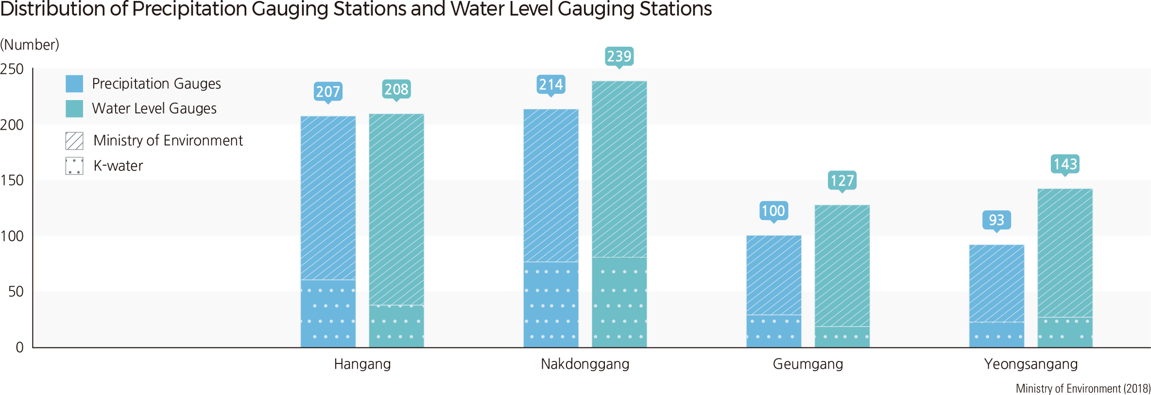
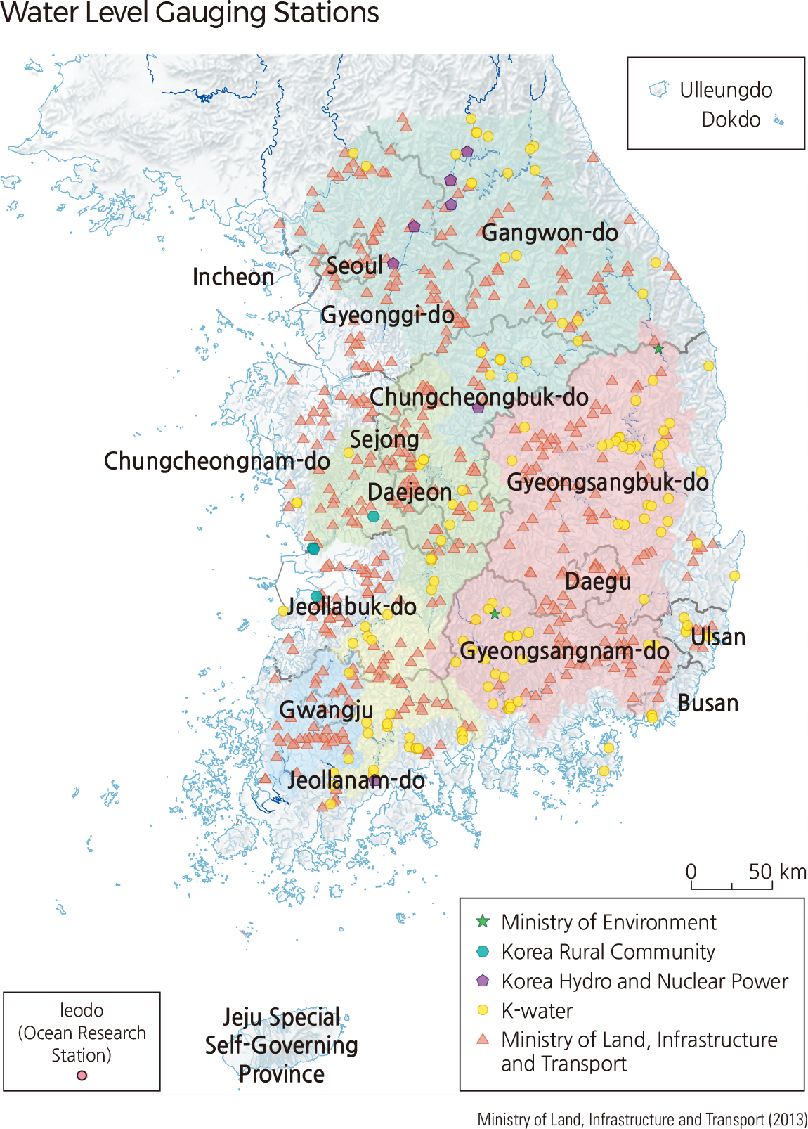
River flow data is important for calculating the quantity of water resources and developing comprehensive water resource management plans and policies. Water level gauging stations are established to record water levels consistently every 10 minutes and calculate flow rate using the stage-discharge relationship formula. A total of 684 precipitation gauges and 618 water level gauges are currently installed along watersheds all across the nation. The Nakdonggang watershed has the largest number of water level gauges at 193, followed by the Hangang watershed at 167 and the Geumgang watershed at 152. The Seomjingang and Yeongsangang watersheds have 58 and 48 water level gauges, respectively.
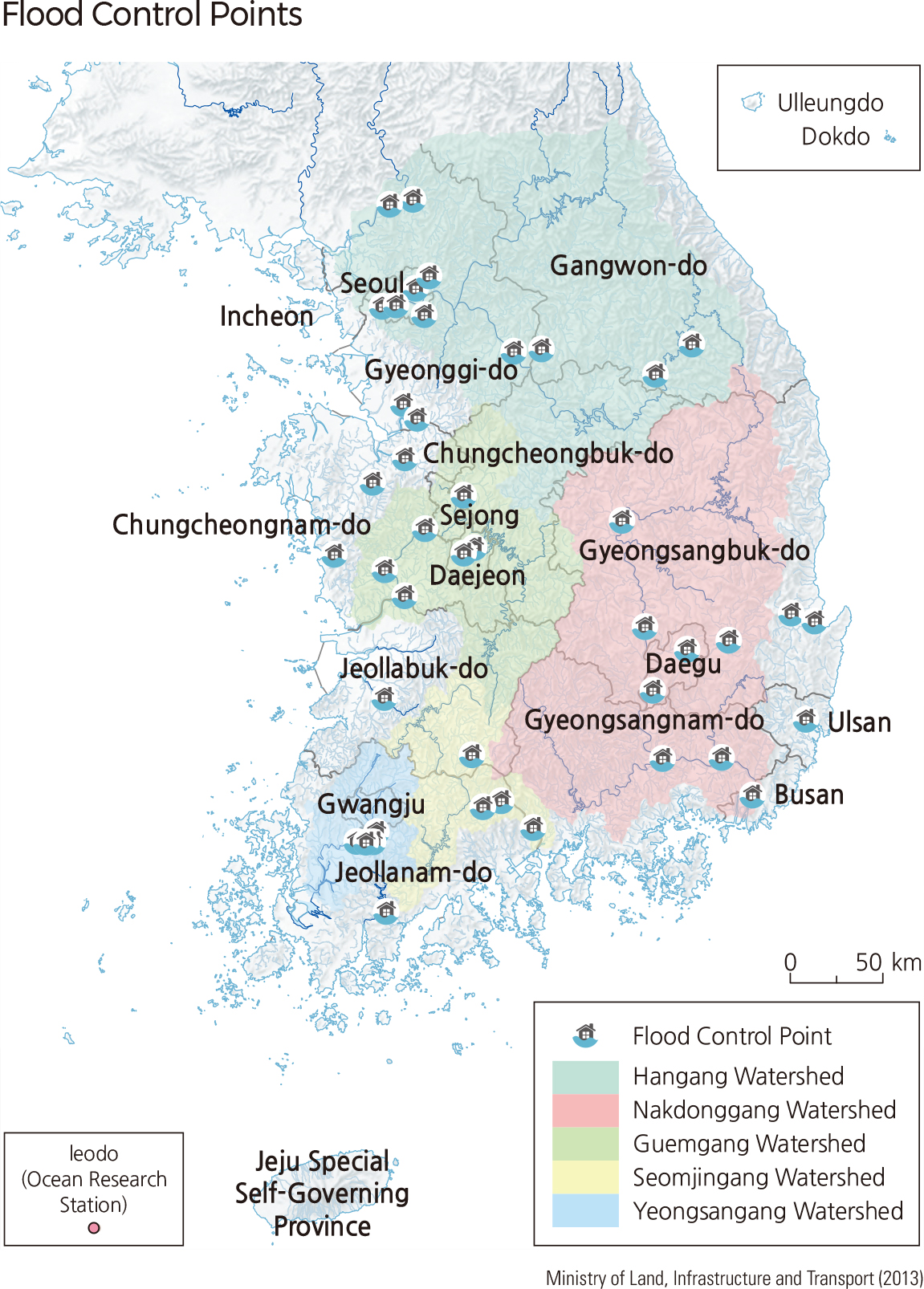
Recent changes in global climate have led to an increase in localized heavy rain, which in turn brought about a rise in consequential damage. Over the past ten years (2005–2014), 383 separate severe flooding events caused more loss than the national subsidy limit. As such, Korea implemented a flood control system that prevents floods to minimize potential casualties and property damage. Initially focused on vulnerable areas of large rivers, the system is expanding to include those of small rivers as well. As of 2015, Korea has a total of 46 flood control offices nationwide. Hangang has 13 offices, including Hangang Bridge and Jamsu Bridge; Nakdonggang has 12, such as Waegwan Railway Bridge in Waegwan-eup, Chilgok-gun, Gyeongsangbuk-do; Geumgang has 8, including Geumgang Bridge, Gongju-si; and Yeongsangang has 13 offices, including Naju Bridge in Naju-si, Jeollanam-do.
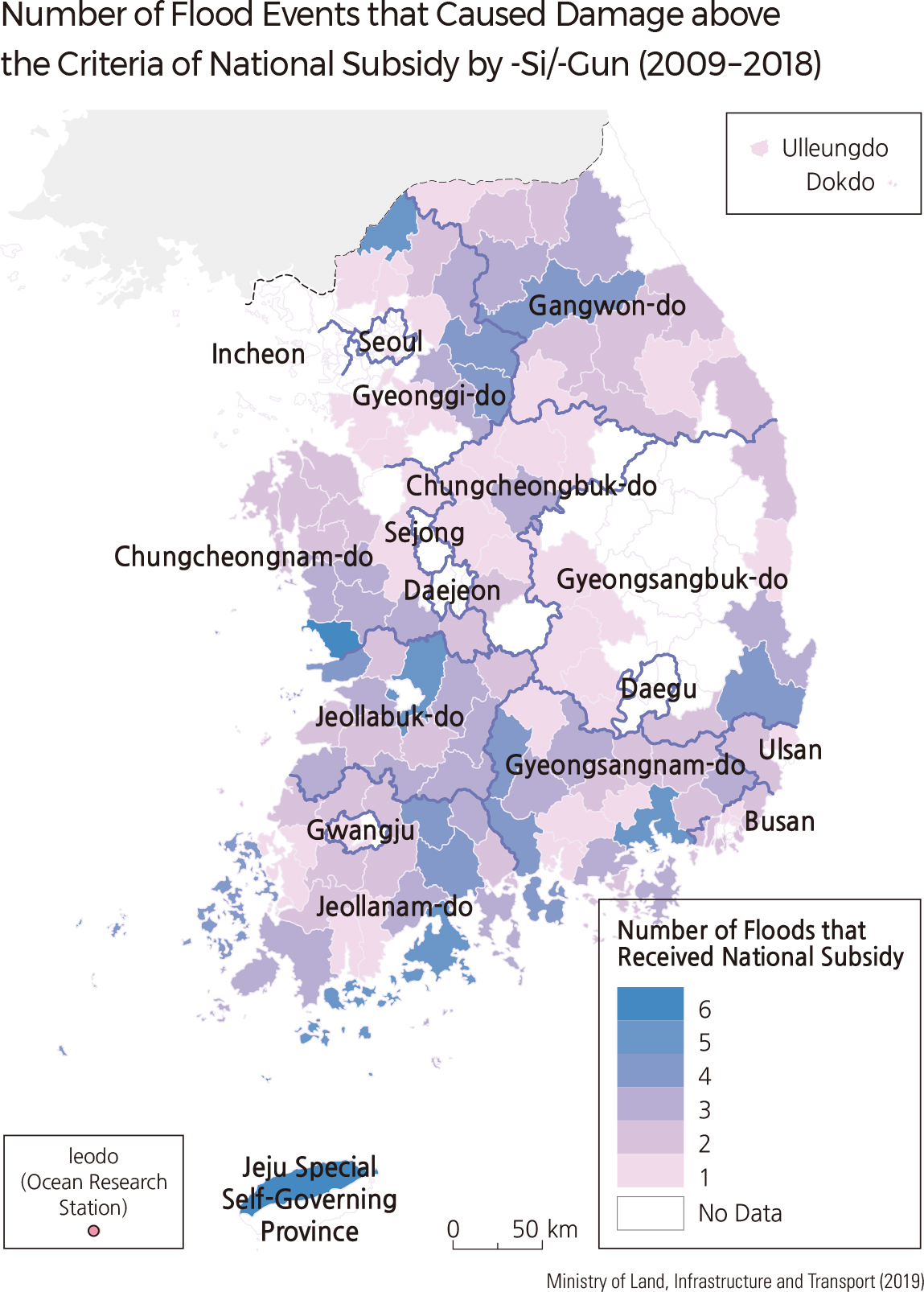
The frequency of localized heavy rains of more than 100 mm per day has increased due to recent global climate change. The amount of damage has also increased as localized heavy rains occur more frequently. In the last 10 years (2009–2018), There were 295 events in which the damage caused by the flood exceeded the criteria of national subsidy. The regions with the most frequent flooding were Seocheon-gun (six events) in Chungcheongnam-do and Jeju-si (six events), followed by Yeoncheon-gun (five events) in Gyeonggi-do, Goheung-gun (five events) in Jeollanam-do, and Wanju-gun (five events) in Jeollabuk-do, respectively. On the other hand, the areas where flood damage above the criteria of national subsidy rarely occurs were mainly metropolitan areas, except for one gu (local district) in Seoul, 12 gus in Busan, and two gus in Gwangju. Gangwon-do, which is geographically vulnerable to flooding, and the southern coastal areas where typhoons often make landfall, have a relatively high number of flood events that cause damage above the criteria of national subsidy. |