English II 2020
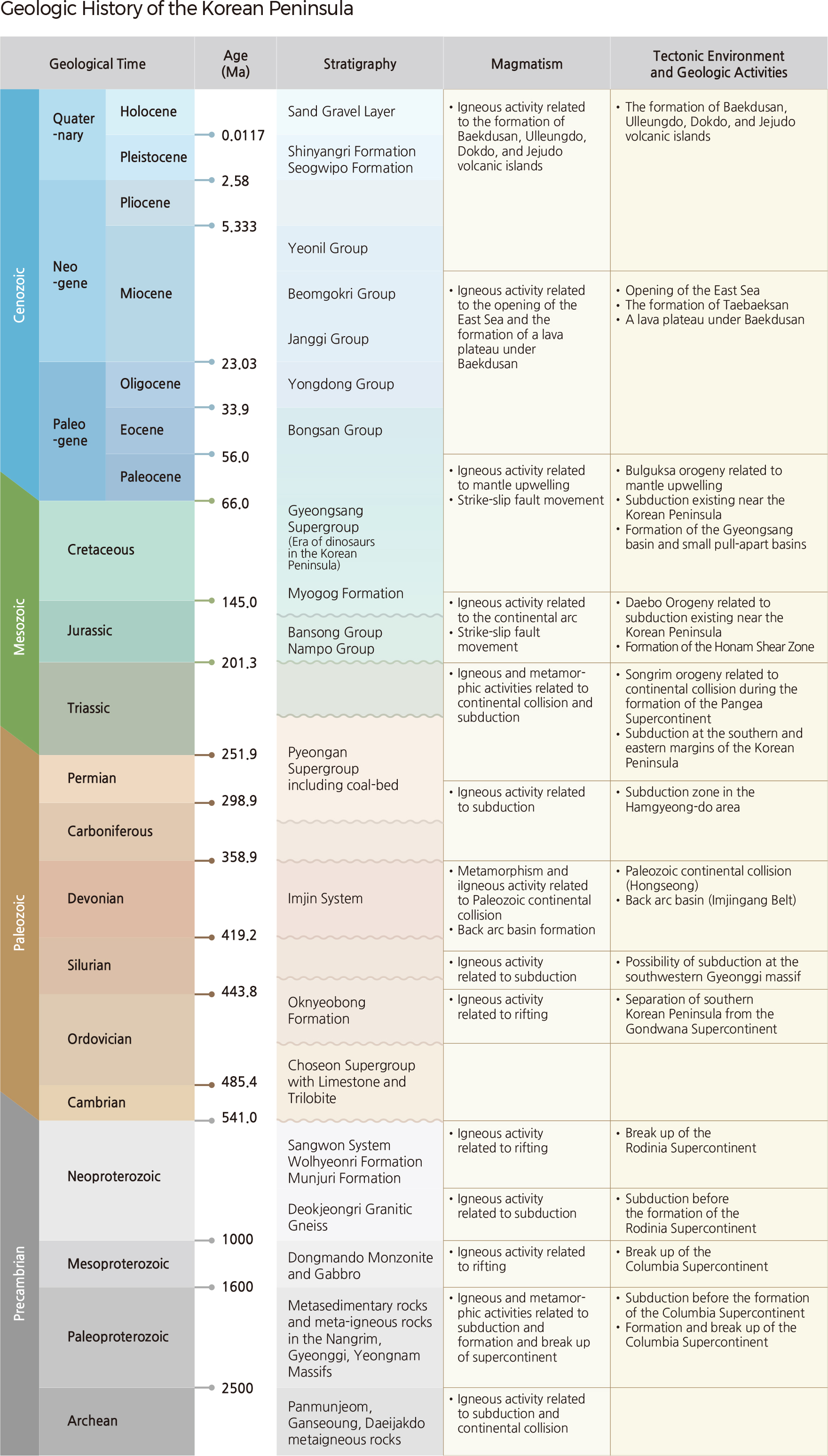
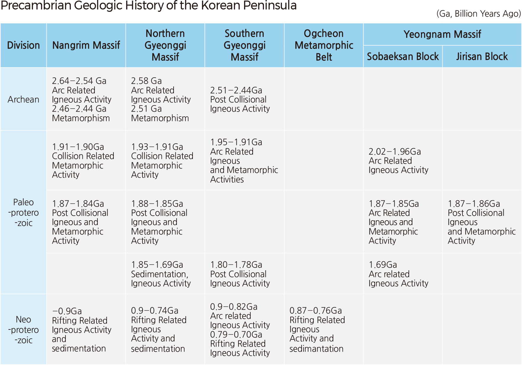
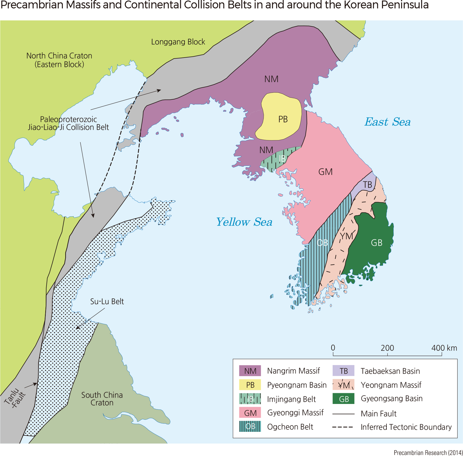
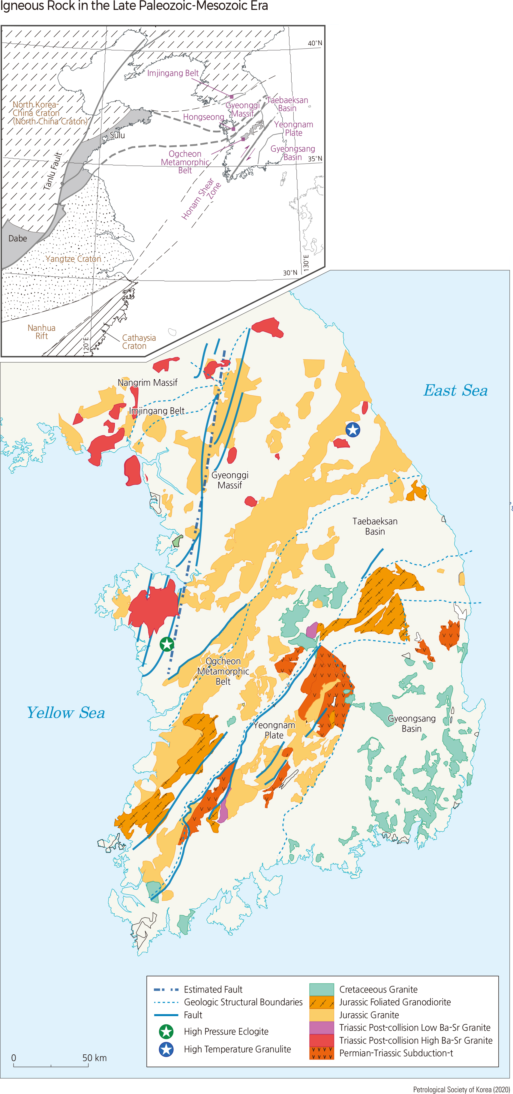
The base of the Korean Peninsula consists of Paleoproterozoic rocks formed around 1.9–1.8 Ga; it is divided into the Nangrim, Gyeonggi, and Yeongnam Massifs by the Ogcheon belt and Imjingang belt. It has long been believed that the Korean Peninsula was created during the Paleoproterozoic era. However, in the early 2000s, it was confirmed that the present shape of the Korean Peninsula is the result of a continental collision during the Permian-Triassic (250–230 Ma). In Hongseong-gun Chungcheongnam-do, evidence of Triassic eclogite was found that supports the continental collision theory. Additional evidence for the continental collision is the Triassic post-collision granitoid found in Odaesan area in Gangwon-do. These data indicate the possibility that the present Korean Peninsula was formed in the Triassic period by the collision between the southern and northern Korean Peninsula along the line connecting the Hongseong and Odaesan areas. Although the location of the collision boundary is still uncertain, some parts of the Korean Peninsula are expected to be connected to the North China Craton while other parts are expected to be connected to the South China Craton. Therefore, in this Atlas, the North China Craton and some parts of the Korean Peninsula connected to it will be called the North Korea-China Craton, and the South China Craton and some parts of the Korean Peninsula connected to it will be called the South Korea-China Craton. The Paleoproterozoic igneous and metamorphic rocks of the Korean Peninsula formed due to the continental collision related to the formation of the supercontinent Columbia (which existed from 2.1–1.8 Ga) and the subduction before that collision. Neoproterozoic sedimentary and igneous rocks formed in several areas from 900–750 Ma. The Paleoproterozoic supercontinent Columbia began to break into separate continental cratons from 1.8 Ga and then the separated cratons assembled again to form the supercontinent Rodinia at around 1,000–850 Ma. Rodinia broke up again into separate cratons from 850– 700 Ma. Neoproterozoic rocks on the Korean Peninsula formed during subduction before the formation of Rodinia and during the breakup of Rodinia.
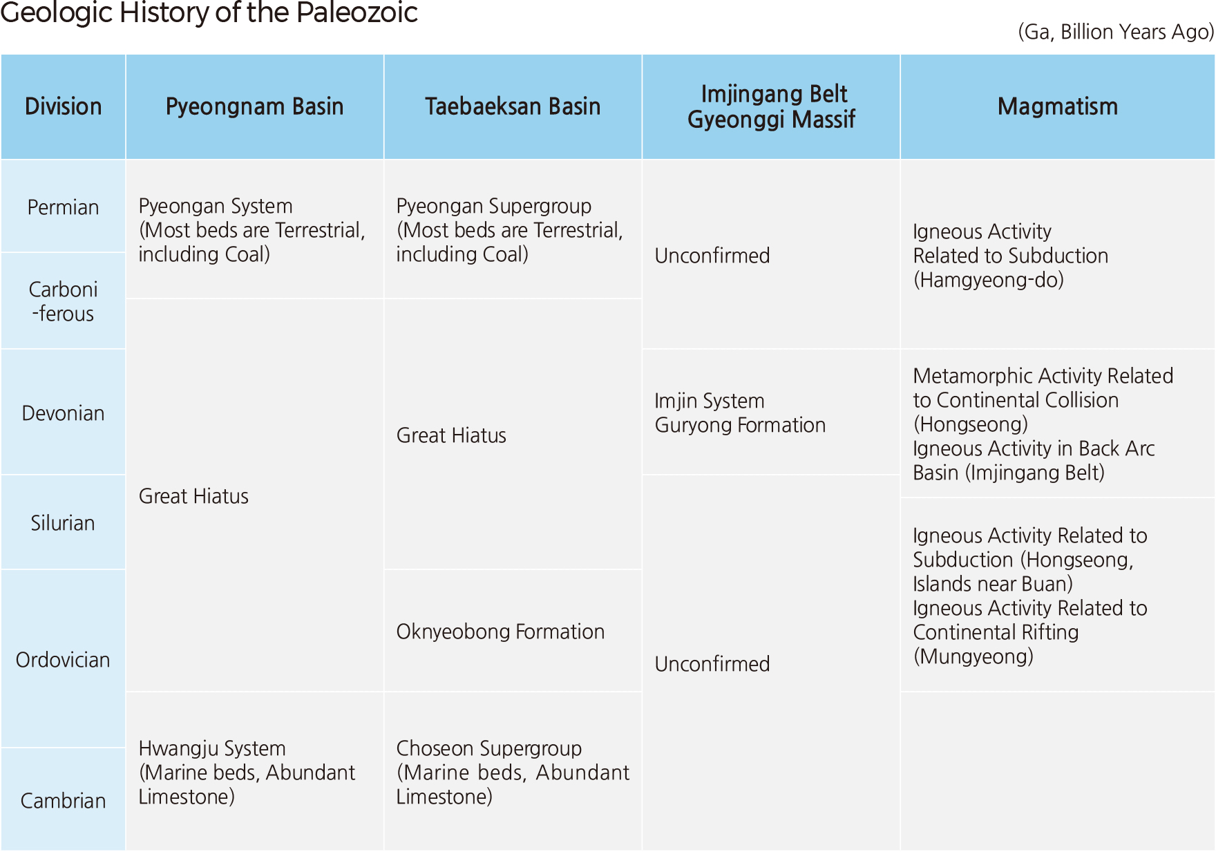
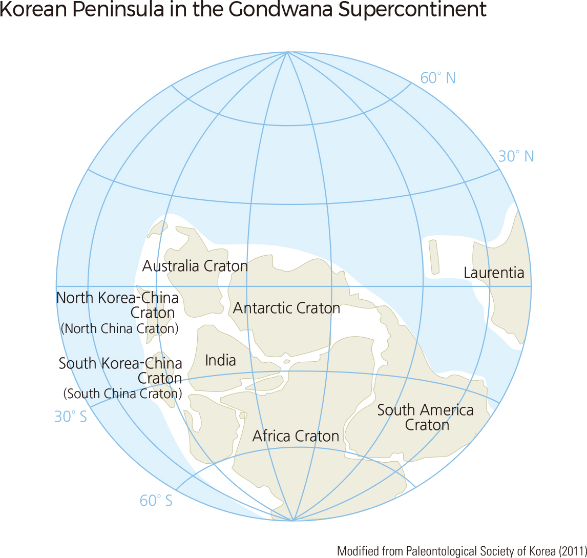
After the disintegration of Rodinia, most continents reassembled, forming the supercontinent Gondwana. At that time, the North Korea-China Craton and the South Korea-China Craton were located on the western side of Gondwana. During the early Paleozoic, these Cratons were separated from Gondwana and moved northward. During this geologic process, the Chosun Supergroup, consisting of Paleozoic marine sediment dated between the Cambrian and early Silurian, was deposited in the Pyeongnam and Taebaeksan Basins. The Pyeongan Supergroup, consisting of non-marine sediments, was deposited on the Chosun Supergroup unconformably. Devonian sediments occur in the Imjingang belt. Between the Carboniferous and Permian, a subduction zone developed, causing subduction-related igneous activity in the northeastern fold belt in Hamgyeong-do. Recently, subduction-related Ordovician igneous activity was reported in Hongseong and Mungyeong areas.
After the separation of the North Korea-China and South Korea-China Cratons from Gondwana during the early Paleozoic, they moved northward and finally collided with each other during the Permian-Triassic, forming the present shape of the Korean Peninsula. At the time of that collision, a subduction zone was initiated along the southern margin of the Korean Peninsula and continued until the Cretaceous. As a result, subduction-related igneous rocks regionally intruded the Korean Peninsula, making up the basement of the Korean Peninsula along with Paleoproterozoic metamorphic rocks. During the Cretaceous, many basins were formed on the Korean Peninsula and in the Yellow Sea. Lakes that formed in the basins provided good habitat for dinosaurs. During the Cenozoic, the East Sea was opened, separating Japan from the Korean Peninsula and forming the Taebaeksanmaek. Also, during this time, volcanic activity resulted in the formation of Baekdusan, Ulleungdo, Dokdo, and Jejudo, and sedimentation occurred in the areas of Gilju-Myeongcheon and Yeonil.
The oldest rocks on the Korean Peninsula are igneous rocks formed during the Neoarchean, 2.6 Ga. Most Precambrian rocks on the Korean Peninsula are Paleoproterozoic rocks. The Nangrim Massif includes igneous rocks formed at 1.93–1.90 Ga and 1.88–1.84 Ga. The former may be related to the continental collision and the latter to the post-collision stage accompanied by the transition from a compressional to extensional stress regime after the continental collision. Similarly, in the northern Gyeonggi Massif, sedimentary and igneous rocks formed during the continental collision (1.85–1.69 Ga).
Subduction-related igneous rocks intruded at 1.95–1.91 Ga and igneous rocks formed during the post-collision stage (1.80-1.78 Ga) were found in the southeastern part of the Gyeonggi Massif. Subduction-related igneous rocks and metamorphic rocks formed 2.02–1.69 Ga were found in the northern margin of the Yeongnam Massif. The meta-igneous rocks formed in the post collision tectonic setting at 1.87–1.86 Ga were found in the southwestern Yeongnam Massif. This distribution of the meta-igneous rocks indicates a continental collision along the line connecting Sancheong and Hadong areas.
The Sangwon System, consisting of Neoproterozoic sediments, runs through the area connecting northern Gangwon-do and Hwanghae-do and extends out to Baengnyeongdo. The Sangwon System was intruded by basic dykes formed at 900 Ma in the continental rift tectonic setting.
Recently, Neoproterozoic igneous rocks of 900–740 Ma formed in the continental rift zone were found in the northern Gyeonggi Massif. Igneous rocks formed during subduction at 900–820 Ma and during continental rifting at 790–700 Ga were reported from the Dangjin-Hongseong area located in the southwestern Gyeonggi Massif. Igneous rocks formed during continental rifting at 870–760 Ma were also found in the northeastern Ogcheon metamorphic belt.
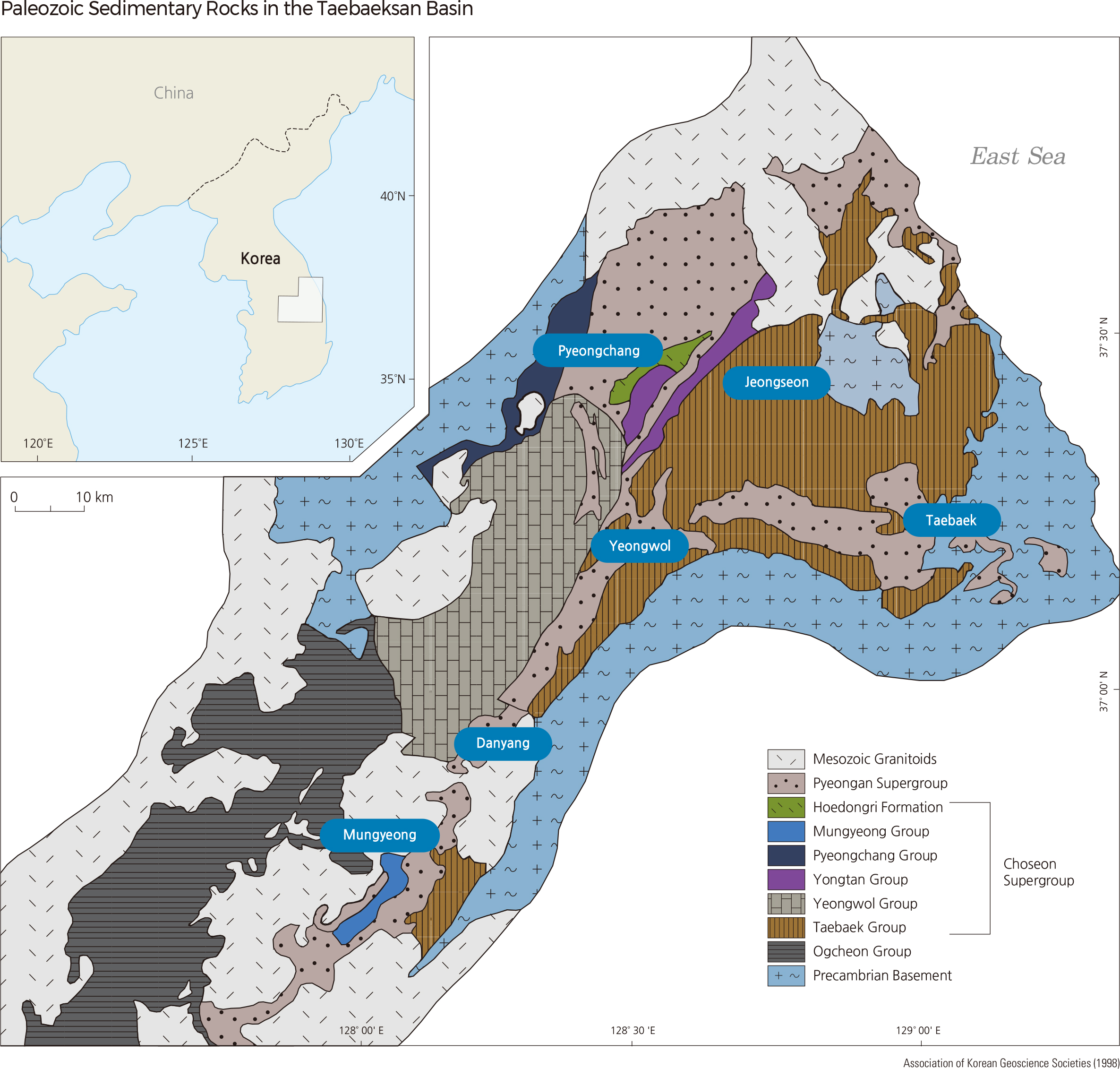
Paleozoic sedimentary rocks are mainly distributed in the Pyeongnam and Taebaeksan Basins and are divided into the Lower and Upper Paleozoic sequences. The Lower Paleozoic sequence is characterized by alternating siliciclastic and carbonate successions deposited from the Cambrian to Ordovician. In the Lower Paleozoic sequence, macrofossils, including trilobites, the index fossil of the Cambrian, occur abundantly with microfossils such as conodonts.
The Upper Paleozoic sequence that unconformably overlays the Lower Paleozoic sequence was deposited from the Late Carboniferous through the Permian up to the Early Triassic and mainly consists of siliciclastic sedimentary rocks with carbonates and coals in the lowermost part of the sequence. The Ogcheon metamorphic belt is comprised mainly of Paleozoic sedimentary rocks. The Imjin series of the Devonian strata, which is absent in the Pyeongnam and Taebaeksan Basins, occurs in the Imjingang belt locating between the Nangrim and Gyeonggi Massifs.
Recently it was reported that the Ordovician bi-modal volcanism occurred at 452–445 Ma in the Ognyebong Formation near Mungyeong. The Ordovician bi-modal volcanism is thought to have occurred when the southern part of the Korean Peninsula drifted apart from the supercontinent Gondwana during the early Paleozoic. The igneous rocks that intruded in the subduction zone at 470–452 Ma and the intermediate- and high-pressure metamorphism that occurred at 442–381 Ma were recognized in the Hongseong area within the Gyeonggi Massif. In the Imjin series of Devonian strata, igneous rocks intruded into the back-arc basin at 373–361Ma. Intensive igneous rocks formed during subduction in the Late Paleozoic were found in the Hamgyeong-do.
One of the most important recent findings is the 230 Ma eclogite from the Hongseong area in Chungcheongnam-do within the Gyeonggi Massif. As the eclogite formed in the subduction zone, the occurrence of this rock indicates that there were a subduction zone and ocean in the Hongseong area, which disappeared due to continental collision. Another important finding is the 230 Ma post-collision igneous rocks in the northern Gyeonggi and southern Nangrim Massifs, which are located on the north side of the line connecting the Hongseong, Yangpyeong, and Odaesan areas. Thus, the 230 Ma eclogite and post-collision igneous rocks potentially indicate that the continental collision boundary may be the line connecting the Hongseong, Yangpyeong, and Odaesan areas. The Imjingang belt and the line connecting the Imjingang belt and Hongseong have also been suggested as the continental collision boundary, but no clear pieces of evidence for the collision were found in those areas. Due to the Permian-Triassic continental collision on the Korean Peninsula, Permian-Triassic regional metamorphism occurred in the Gyeonggi Massif, Imjingang belt, and Ocheon metamorphic belt.
Along the southern margin of the Korean Peninsula, subduction-related igneous activity started to occur between the Late Permian and Triassic. Therefore, during the Songrim Orogeny, the post-collision igneous activity and subduction-related igneous activity occurred in the middle and the southern parts of the Korean Peninsula, respectively.
During the Jurassic, Japan was attached to the Korean Peninsula. A subduction zone existed at the eastern and southern margins of the Korean Peninsula, resulting in the extensive regional intrusion of Jurassic granite in the Korean Peninsula. This event is called the Daebo Orogeny.
During the Cretaceous, a subduction zone was also developed along the margin of the Korean Peninsula, and Cretaceous igneous rocks intruded the Korean Peninsula regionally due to the mantle upwelling which was caused by rollback of subduction slab towards Pacific Ocean side. The Cretaceous igneous activity mainly occurred in Gyeongsang-do, Jeolla-do, and southern Chungcheongbuk-do.
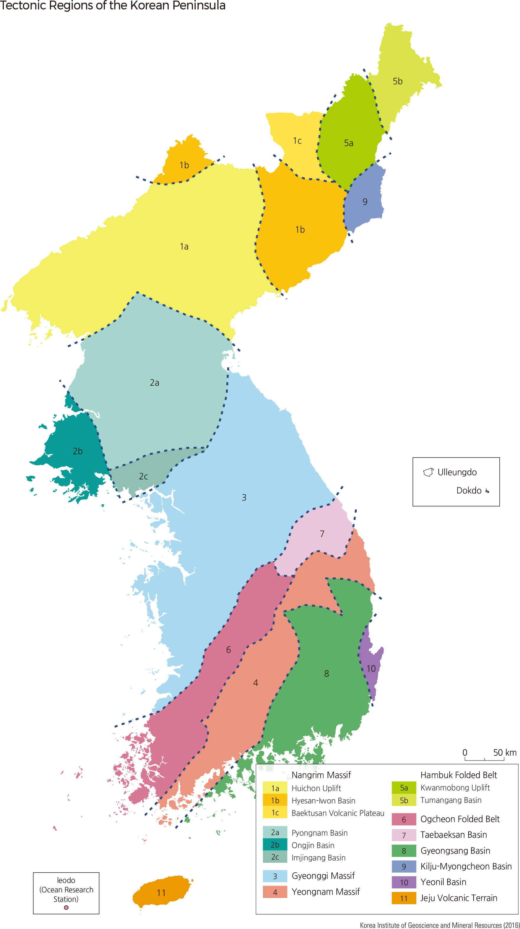
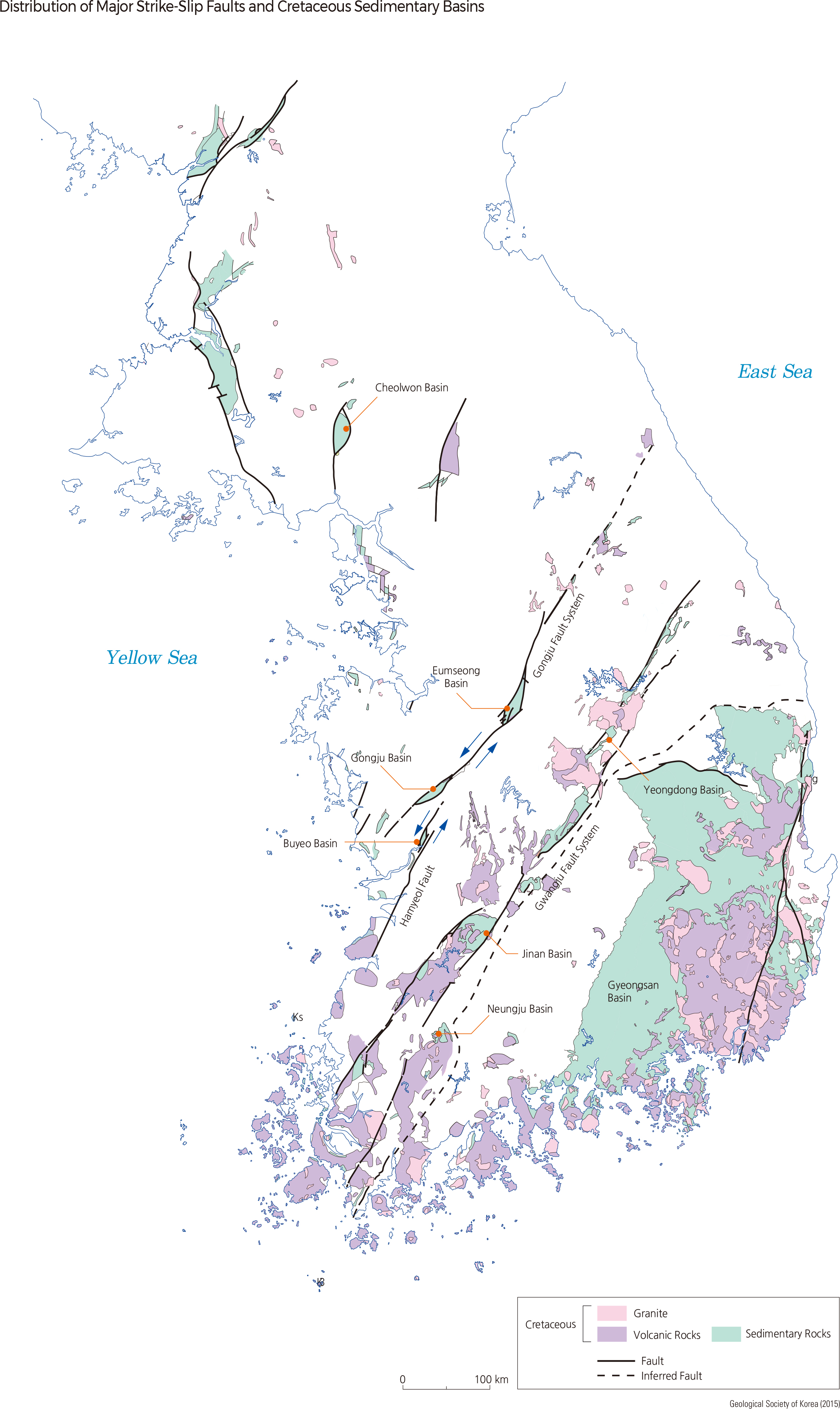
The Cretaceous Gyeongsang Supergroup consists of continental sedimentary rocks deposited in lacustrine environments and is widely distributed in the Gyeongsang Basin and the Namhwanghae Basin. Cretaceous sedimentary rocks are also deposited in the small basins formed during the Cretaceous across the Korean Peninsula. The small-scale Cretaceous basins were pull-apart basins formed by the extension between or along the strike-slip faults, which underwent left lateral movement (the opposite part of the fault moves left) with a northeast strike. 0 50 km
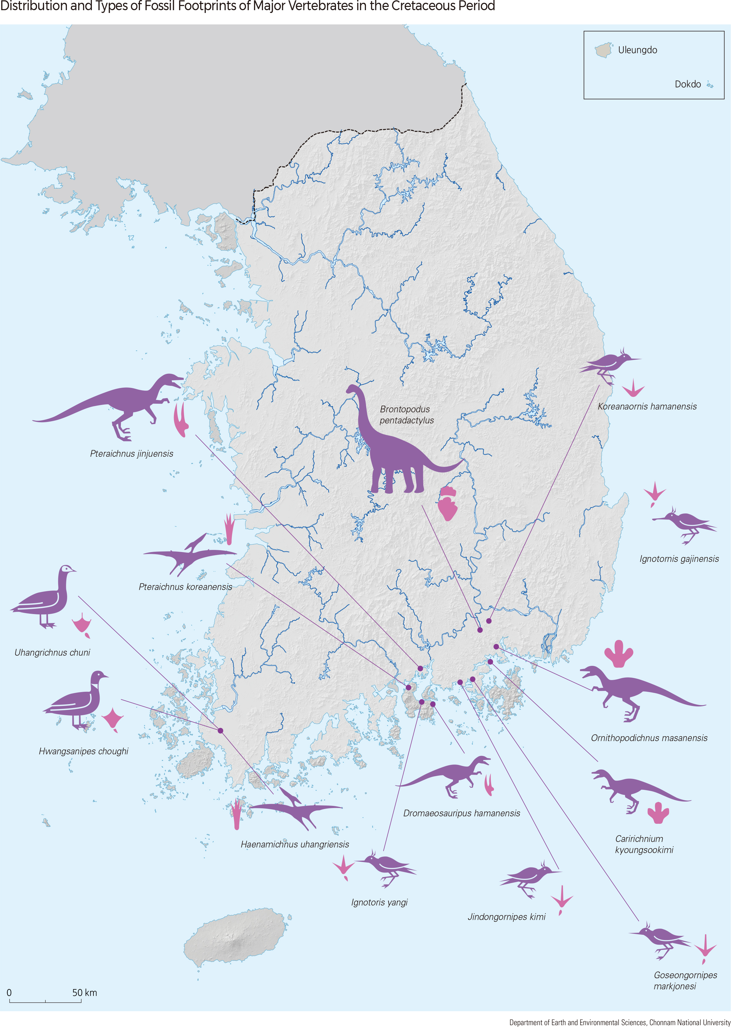
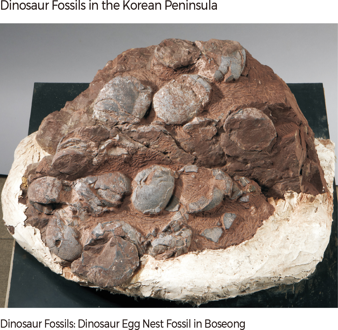
The Cretaceous terrestrial (non-marine) sedimentary layers on the Korean Peninsula contain abundant dinosaur fossils, including footprints and egg and bone fossils. In 1972, the first dinosaur fossil found on the Korean Peninsula was an egg fossil from the Hadong-gun in Gyeongsangnam-do.
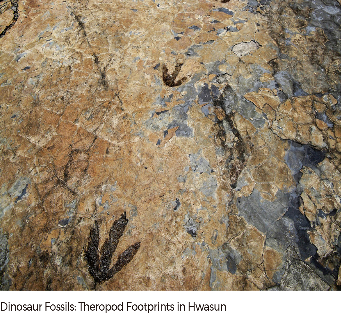
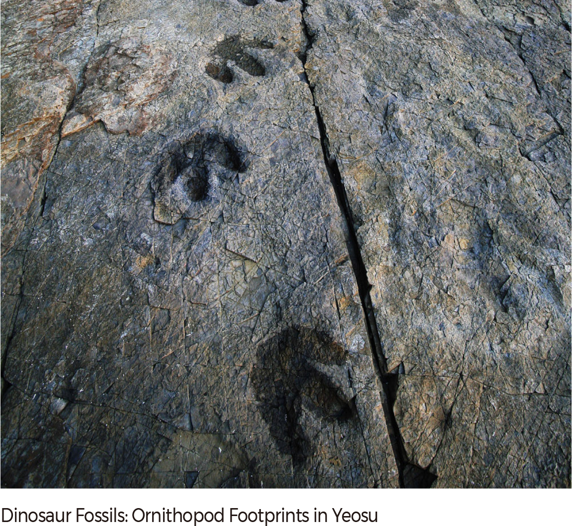
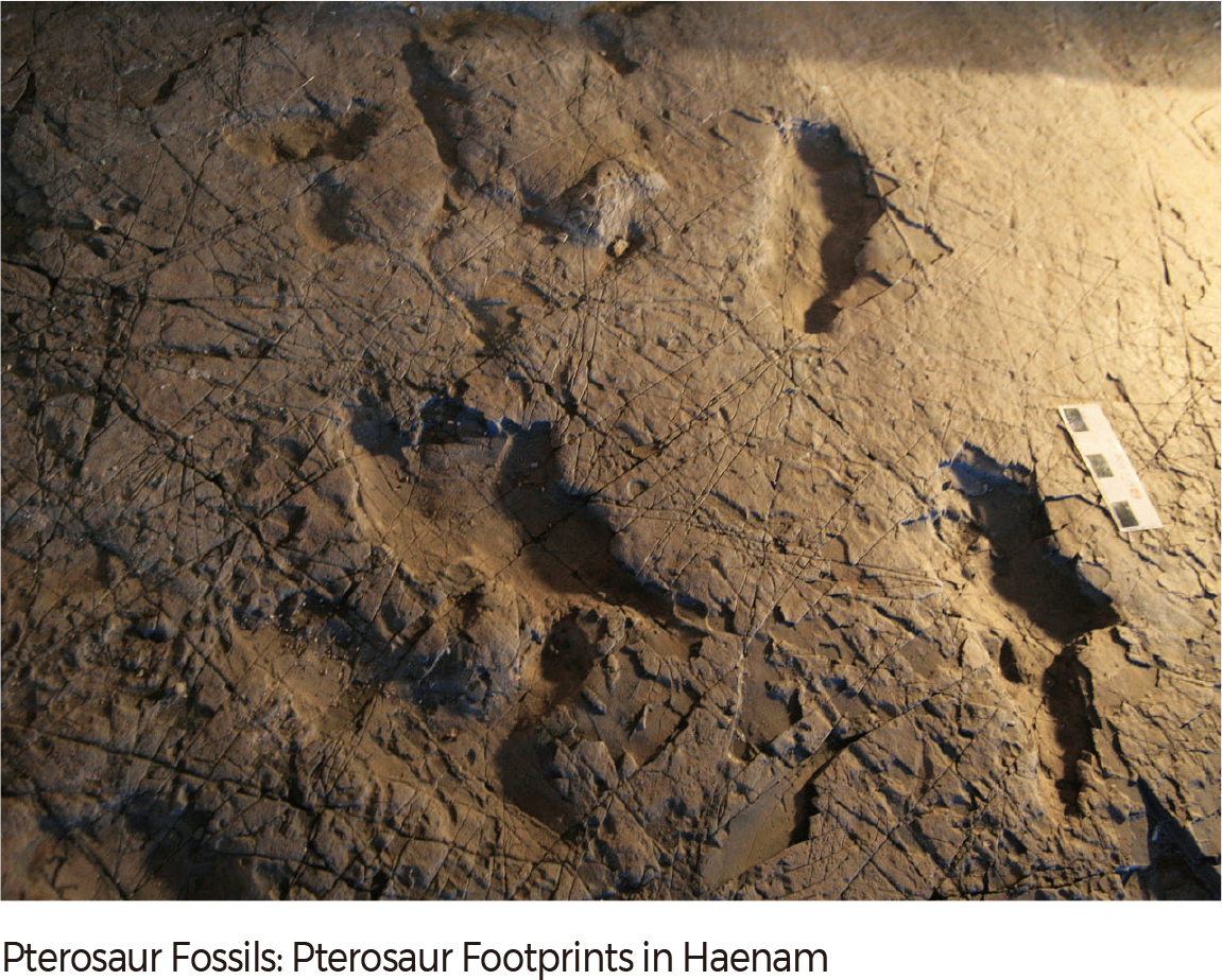
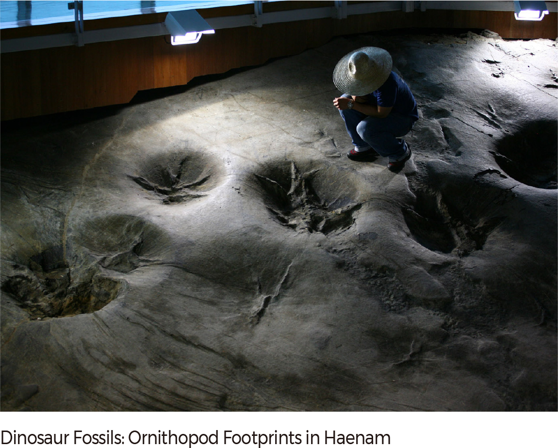
Dinosaur footprint fossil sites are found in the 27 Cretaceous terrestrial sedimentary layers in the southern region of the Korean Peninsula; the Cretaceous terrestrial sedimentary layers in Hanam-gun, Hwasungun, and Yeosu-si within Jeollanam-do, and Goseong-gun within Gyeongsangnam-do, are representative sites. Ornithopod footprints are very abundant on the Korean Peninsula, and representative theropod footprints have been found in Hwasun-gun within the Neungju Basin. Abundant sauropod footprints are reported from the Jindong sedimentary layer in the southeastern region of the Korean Peninsula, and the diverse size, shape, and trackway of sauropod footprints indicate that diverse sauropods lived on the Korean Peninsula. The pterosaur found in Uhangri, Haenam-gun, was internationally approved as a new species named Haenamichnus uhangriensis.
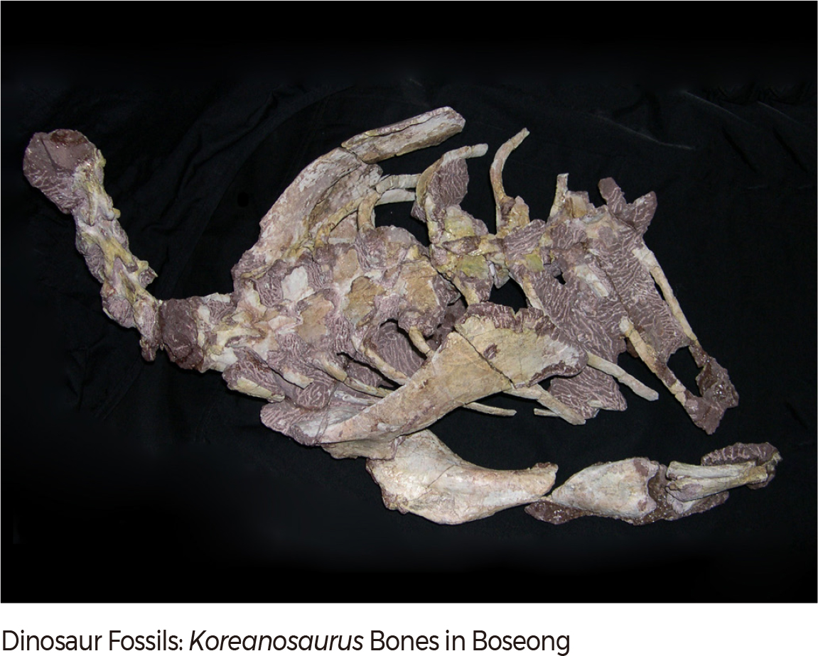
The largest number and the widest trackway of pterosaur footprints (443 and 7.3 m, respectively), are found in the Uhangri area. In this area the footprints of pterosaurs, dinosaurs, and birds occur together in the same sedimentary layer, which is very rare in the world. For the first time in Korea dinosaur bone fossils that are sufficiently preserved to identify the species of dinosaurs were found in the sedimentary layer in Hadong-gun, Gyeongsangnam-do; the bone fossils were identified as a new species, Pukungosaurus millenniumi. It was registered as the 931st dinosaur genus in the world inventory of dinosaurs.
During the Cretaceous, many lakes existed in the southern region of the Korean Peninsula. Gymnosperms, including conifers and ferns, and various vertebrates and invertebrates were also abundant in and around lakes. These lake environments made the Korean Peninsula a habitat favorable for dinosaurs during the Cretaceous.
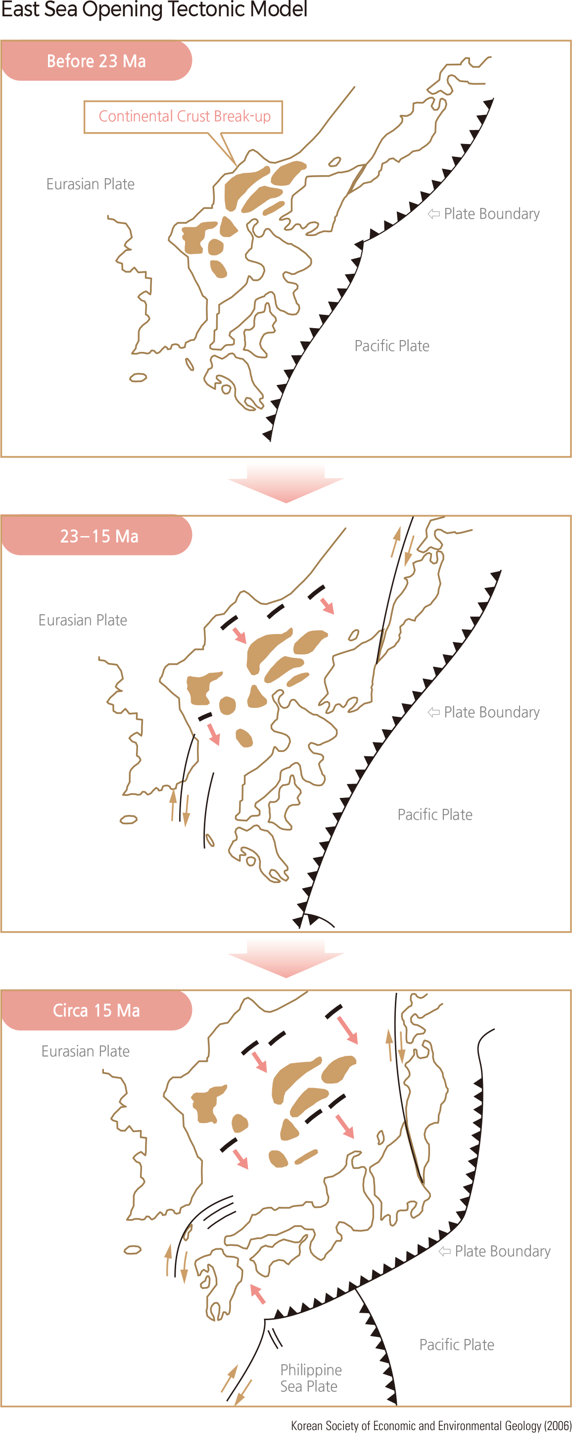
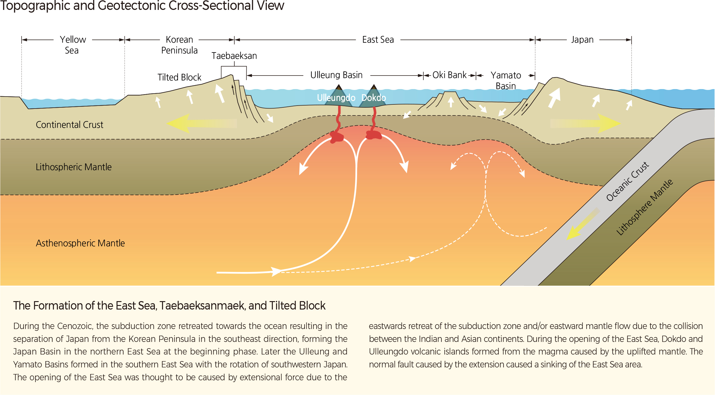
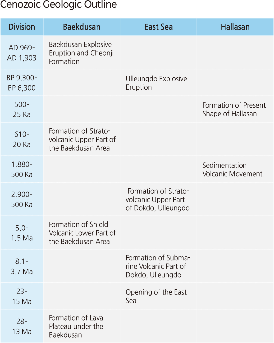
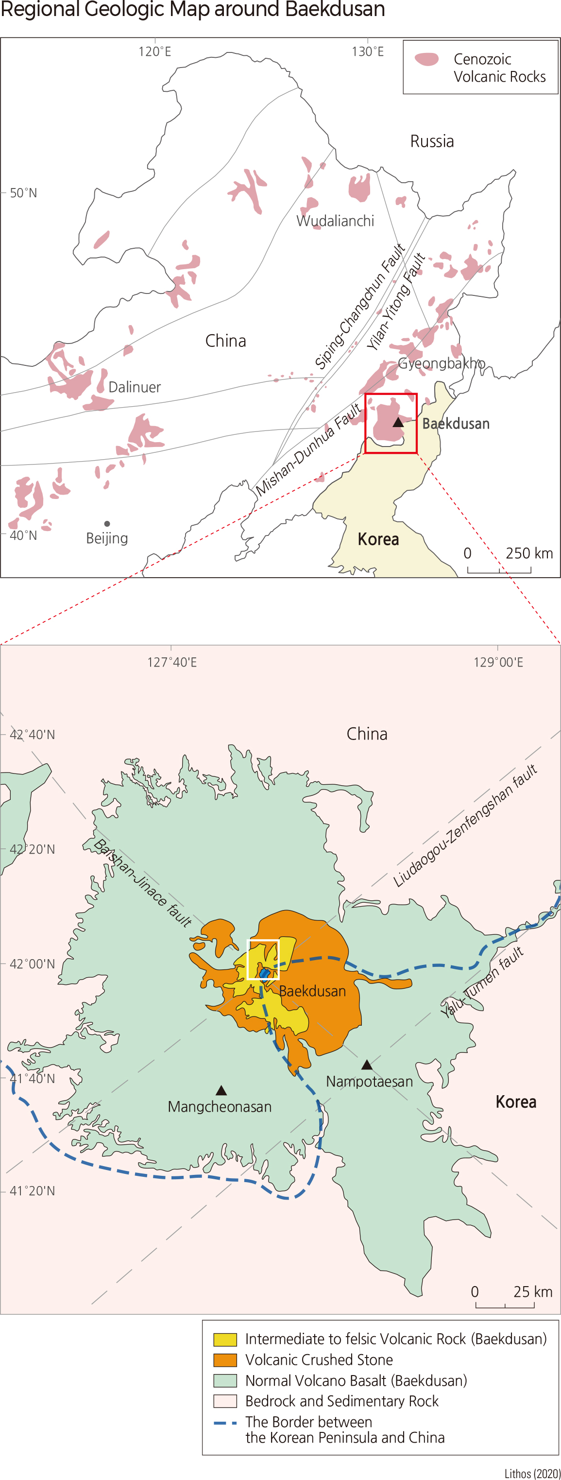
The Cenozoic can be defined by the appearance of the East Sea, Baekdusan, Hallasan, Ulleungdo, and Dokdo. The timing of the formation of the East Sea (23–15 Ma) is similar to the timing of the regional formation of lava plateaus (28–13 Ma) in northeastern Asia, including the Baekdusan area. It indicates that there was a regional extension in Northeast Asia, which formed enormously long fissures in the East Sea and Baekdusan area.
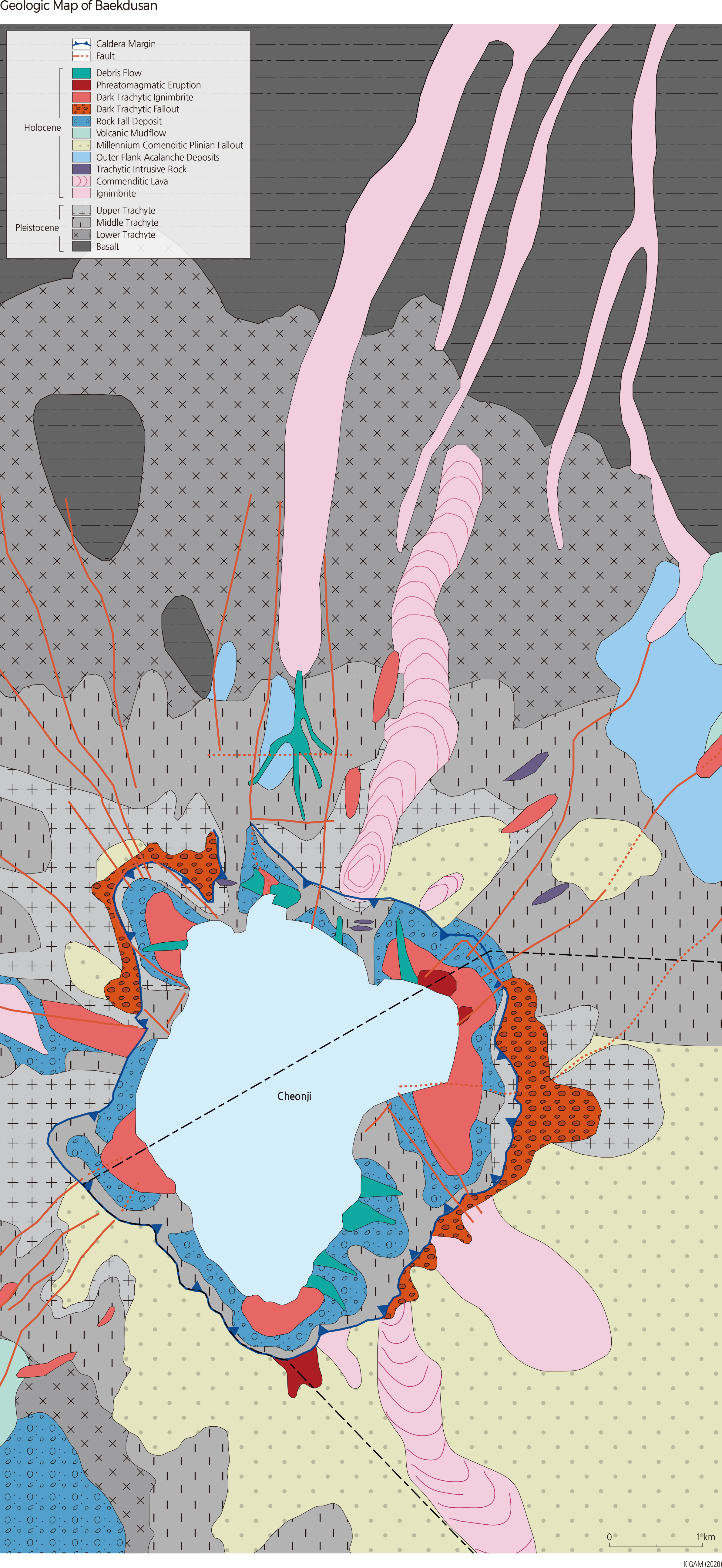
From 15 Ma, compressional stress replaced extensional stress. As a result, shield volcanos formed on the lava plateau in the Baekdusan area by the central extrusion of basaltic lava during 5–1.5 Ma, and the submarine volcanic part of Ulleungdo and Dokdo may also have formed in the East Sea during 8.1–3.7 Ma by submarine volcanic activity. Finally, a stratovolcano consisting of trachytic and rhyolitic volcanic and pyroclastic rocks formed in the Baekdusan area during 0.61 Ma–1903, and in Ulleungdo and Dokdo during 2.9 Ma–6300 BP. At around 969 CE, Baekdusan experienced its strongest eruption, forming the Cheonji Caldera. During this eruption, volcanic ash was transported to the East Sea and Japan and sedimented there. This suggests that similar tectonic activities formed the East Sea, including Ulleungdo and Dokdo, and Baekdusan.
In the eastern coastal area, normal fault movement occurred due to the regional extension during the opening of the East Sea, resulting in the deepening of the East Sea. Together with the sinking of the East Sea, the Taebakesanmaek was formed by the uplift of the eastern coast tilting the Korean Peninsula westward. Unlike the East Sea, the Yellow Sea formed on submerged land due to sea-level rise during the interglacial period.
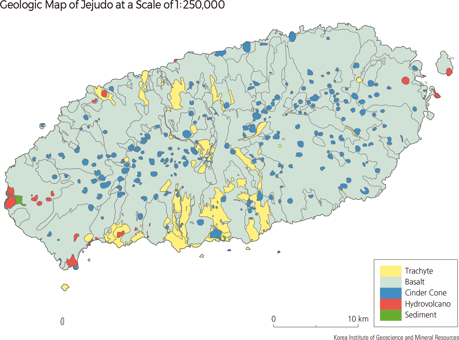
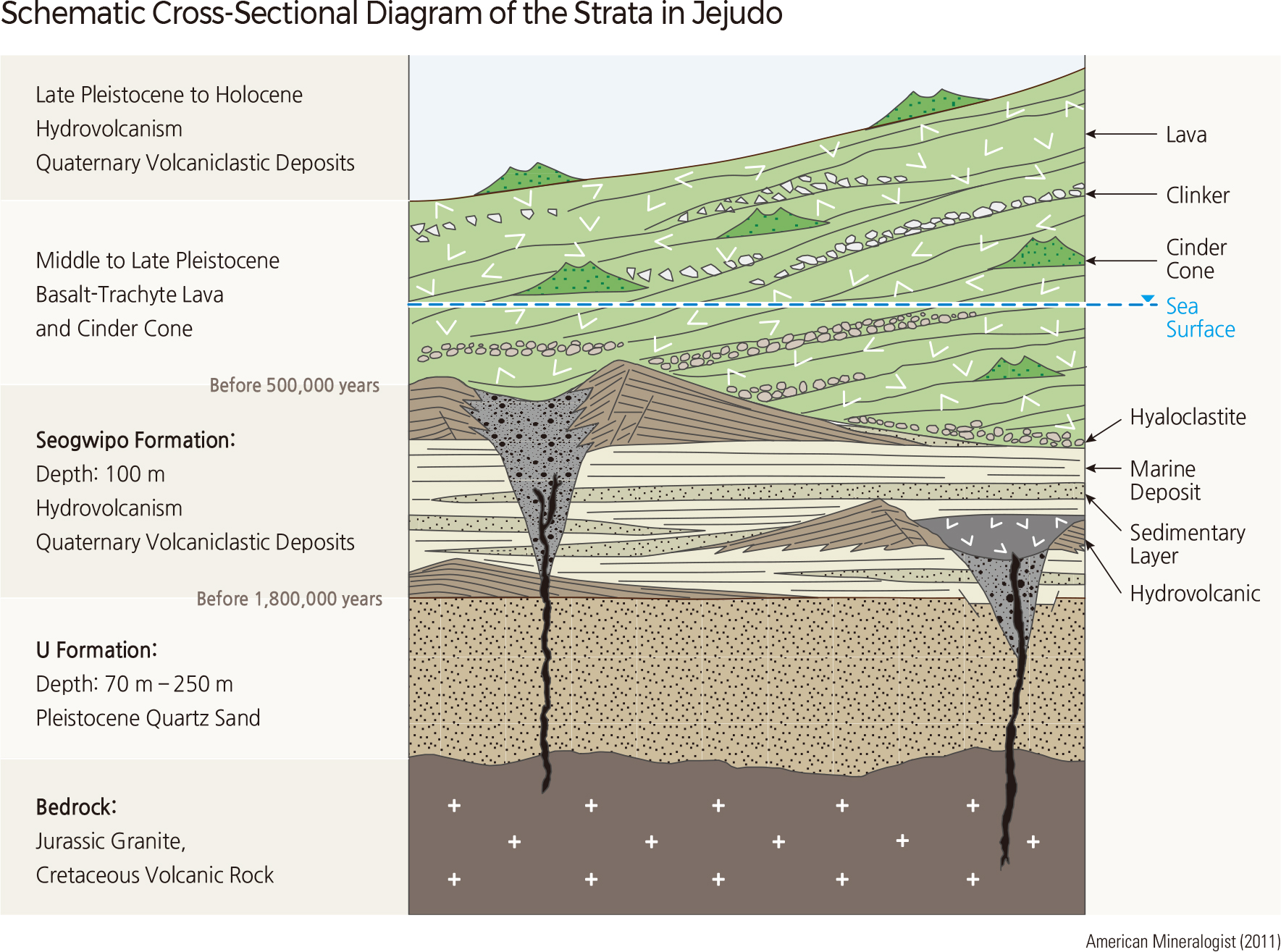
Jejudo shows different geological characteristics compared to Ulleungdo and Dokdo. It took about 1.8 million years for Jejudo to take its present shape. The volcanic activity of Jejudo can be divided into two stages: hydrovolcanic activity (1.88–0.5 Ma) and lava effusion on land (0.5 Ma–25 Ka). The hydrovolcanic activity occurred locally and sporadically in the first stage, and the lava effusion occurred actively and regionally on land, forming the present shape of Jejudo, in the second stage.
Jejudo was created from volcanic activity within the Yellow Sea continental shelf about 1.8 Ma. The initial volcanic activity of Jejudo was hydrovolcanism. During the Quaternary, sea level has fluctuated dramatically, varying between glacial periods and interglacial periods. Volcanic activity has alternately occurred on the seafloor and on land. Hundreds of tuff rings and tuff cones have been created by sporadic hydrovolcanic eruptions over a million years. During the Quaternary, as the Seogwipo Formation, a mixture of tuff and terrestrial and marine sedimentary rocks, accumulated over 100 m, Jejudo grew above the sea level and became an island. Since about 500 Ka, lava effusion has taken place predominantly on land. The Hawaiian eruptions created the lava plateau and shield volcano, and the Strombolian eruptions that occurred everywhere on the island created numerous cinder cones called “oreum.” The current shape of Hallasan was completed about 20 Ka. About 4–5 Ka, hydrovolcanic activity took place on the seashore again, forming oreums including Seongsan Ilchulbong and Songaksan; volcaniclastic sedimentary strata, such as the Sinyangri Formation and Hamori Formation, were formed in the surrounding areas. According to ancient documents, a lava eruption occurred on the hillside of Hallasan in 1002 CE. In 1007 CE, a hydrovolcanic eruption occurred on the seashore, but its location is not confirmed yet.
The history of the volcanic eruption of Baekdusan is divided into four periods. In the first period, a basaltic lava plateau was formed by the fissure eruptions. In the second period, central eruptions occurred to form a shield volcano like Jejudo on the lava plateau. In the third period, explosive volcanic activity occurred as composition of magma was changed to felsic or intermediate, and as a result, a younger bell-shaped stratovolcano was built on the top of the shield volcano. During the Holocene (1690 BCE–1702 CE), explosive eruptions occurred. The eruption in 969 CE was a large-scale volcanic eruption estimated to be tens of times stronger than the Vesuvius eruption that destroyed Pompeii. Baekdusan is a very peculiar volcano developed inside the continent and its origin is not clearly identified.
The frequency of volcanic earthquakes increased sharply in the vicinity of Cheonji, the caldera of Baekdusan, from 2002 to 2006, then decreased. Currently, the frequency of volcanic earthquakes is similar to that of 1999–2001. All earthquakes that occurred during this period were caused by the activity of a magma chamber located 2–4 km underground. Recent studies have identified a magma chamber located 5–10 km underground. From 2002 to 2007, the volcanic body of Baekdusan expanded and rose about 10 cm. In 2004, the groundwater temperature around Cheonji rose from 69ºC to 83ºC. These pieces of evidence indicate that it is necessary to investigate the conditions and potential for eruption of Baekdusan. |