Over a long period of time, Korea has experienced various changes in its patterns of land use. Urban construction took root in basins and along major rivers, and cities gradually expanded with the growth of the population. Roads and railways were constructed to connect cities, leading to the further development of new metropolitan centers in surrounding areas. Farmlands for crop production and pastures for livestock also increased throughout the years. Hills were cultivated for upland farming fields, many of which have been converted into rice paddies through modern irrigation methods. In recent years, however, there have been instances where rice paddies are converted into upland farming fields in order to grow more lucrative products such as ginseng, fruits, and highland vegetables. In coastal regions, new land was created by reclaiming land from the sea.
Although land use has shifted in order to fit human demands throughout time, such changes have the potential to cause serious environmental problems. The expansion of urban and agricultural areas inevitably led to the decrease of forest areas, which in turn triggered an increase in greenhouse gas emissions, a decrease in the absorption of carbon dioxide, and the risk of natural hazards. Forest fragmentation resulting from the construction of residential areas, roads, and railways is threatening the livelihood of plants and animals living in the forest ecosystem. Environmental problems such as odor and leachate (polluted water or liquid leaching down to the subsoil, potentially moving into drinking water aquifers, and possibly creating other problems) arise due to waste landfills in metropolitan areas. Coastal land reclamation has caused a decrease in tidal flats, leading to biodiversity loss and an increased danger of near-shore disasters.
Korea has been making efforts to minimize environmental problems and achieve sustainable land use. Land use and land cover maps have been developed to understand the status of the surface of the earth and analyze the best land use practices accordingly. Along coastal shorelines, surveys are in progress to assess and monitor the restoration of marine habitats that have been destroyed. Waste landfill sites that are located near big cities are being developed into parks in order to minimize odor and leachate. Furthermore, Korea aims to prevent badly designed development projects with the launch of the National Environmental Zoning Map and also encourage eco-friendly land use by sharing regulatory information with the public. South Korea and North Korea display a large difference in land use and land cover patterns. South Korea has an area of approximately 100,000 square kilometers, while the area of North Korea is about 120,000 square kilometers. According to a land cover map from the late 2000s (2008–2010) produced by the Ministry of Environment, the total size of all urban and developed areas of South Korea is approximately twice that of North Korea. The urban and developed areas in South Korea amount to 3,700 square kilometers, which represents 4% of the total area. The urban and developed areas of North Korea comprise 2% of the total area, at approximately 1,900 square kilometers. These areas are generally located in basins or estuaries. By contrast, the agricultural areas of North Korea are more extensive than those of South Korea. In South Korea, 20% of the total area (20,000 square kilometers) is used as agricultural land, compared to 24% in North Korea (30,000 square kilometers).
Over the Korean Peninsula, approximately 70% of the total land area is covered by forests. High mountain areas are mostly located in the eastern and northern regions while low elevations and gentle slopes primarily appear in the western region. Due to these topographical settings, agricultural areas are mainly distributed in western regions and forest areas are located towards eastern regions.
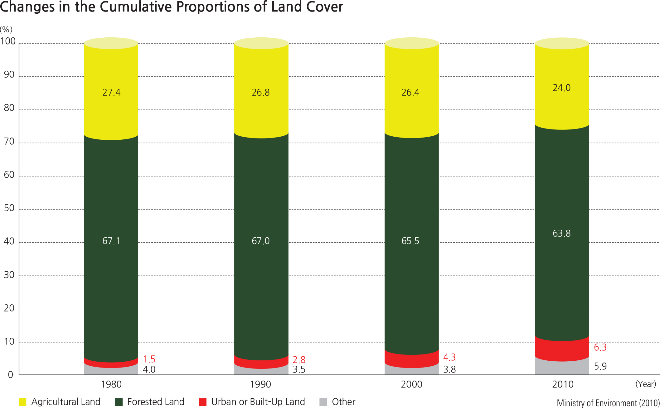
Since 1975, urbanized areas have gradually been expanding around major cities such as Seoul, Busan, Incheon, Gwangju, Daejeon, and Ulsan. Areas surrounding the transportation networks between such metropolitan regions have also become increasingly urbanized. While agricultural lands have shrunk in mountain areas due a decrease in rural population, they expanded in coastal plains and hilly areas as a result of active land reclamation. Urban and agricultural expansion has also led to deforestation, which may cause various environmental issues such as global warming and flood hazards. Significant efforts are being made in order to minimize these potential environmental problems and also heighten the value of forest areas. As such, forest resources are closely monitored and forest protection areas are designated accordingly. In 2010, forested land was recorded as the largest land cover type, followed by cropland, urbanized and developed land, and others.
Brief Interpretation of the Map
A brief look at the land-use/land-cover map gives an impression of the land as largely covered in forest, agriculture, grassland or urban -use. However, the dark green forest coloring tends to override the other categories. Also, the graph on the change of land-use over the last 40 years greatly simplifies the general pattern. The graph shows a land-cover dominated by forest and agricultural land with a relatively small decrease in forest, and a smaller decrease in agricultural land. However, these slight changes are also masked by the number of small changes within the broad categories and the composition of the changes in the large categories. The whole texture of what processes are operating in the map may not be apparent at first glance. It is useful to take a pattern that one is familiar near their home setting and then look closely at what is happening in a similar place in Korea. Most of us are familiar with how the transitional area from urban to non-urban land appears, as one travels out past the edge of town. In most small cities, the transition from urban to agriculture is common and familiar, but the transition from urban to forest is less familiar. The scale of this map necessarily hides small transitions normally seen in the real world. However, the direction of a transition is not always the same. Urban land may move into and replace forest land on the timescales of months, years and decades, but the opposite does not happen on the same timescale. A forest does not move into and replace urban land on such short timescales.
In the transitional areas, there are often areas of environmental stress, simply because the built urban environment can change quickly and the natural one is the result of a series of slow processes. It is most useful to study this collage of patterns in small areas at a time. Tracing a narrowing valley to its head allows one to see more about the character of this collage than scanning across the terrain.
Study the Land-cover/Land-use patterns around the city of Daegu, which is in a mountainous area, and also the coastal city of Busan. Daegu is situated in a large valley. Agriculture exists on each side of the city, while forest occupies areas on the north and south sides of the city. Busan has internal forest areas and agriculture on the landward side. Place yourself 25 years in the future and project what changes you could expect to see given the patterns of the last 25 years.