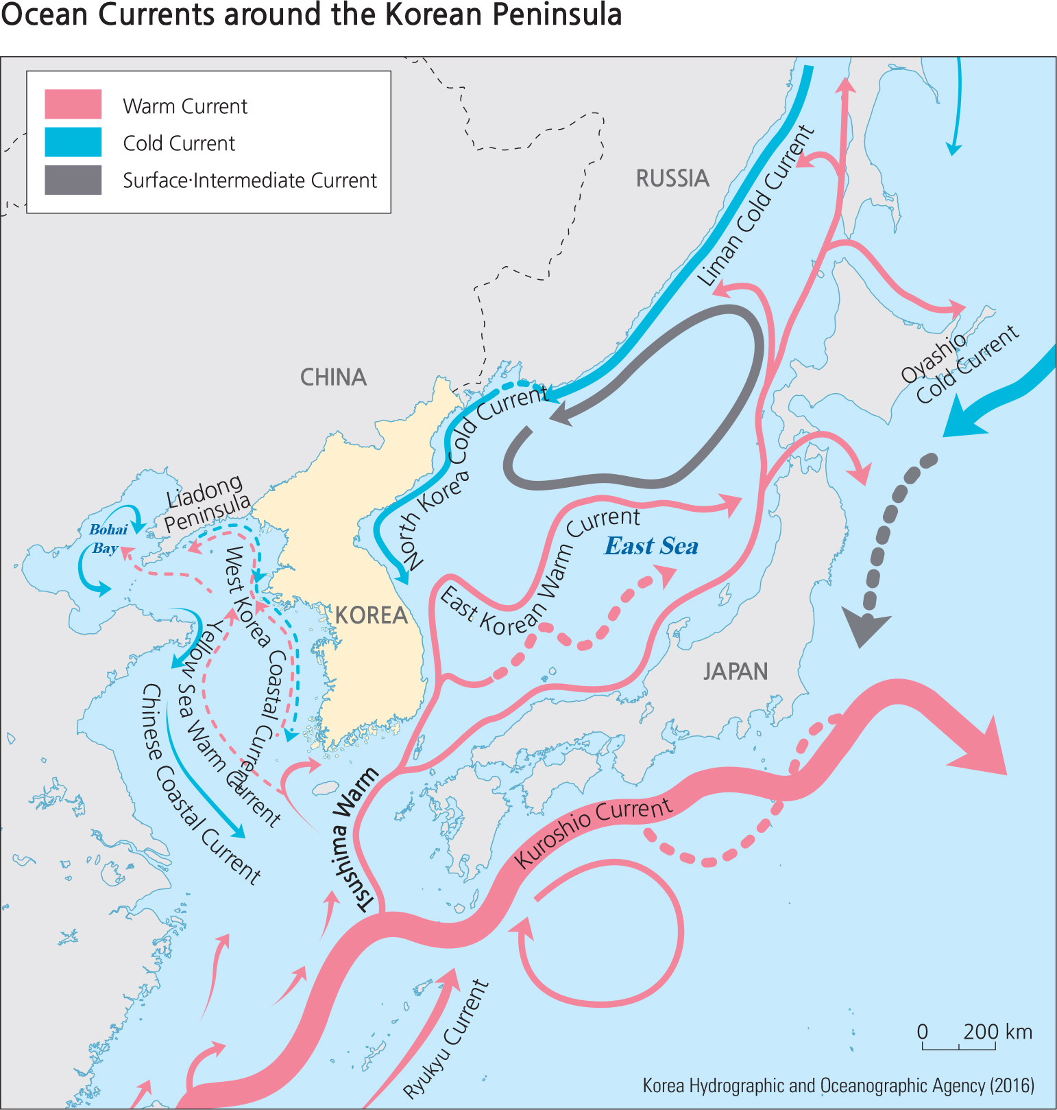
The Korean Peninsula is influenced by the Yellow Sea Warm Current, East Korean Warm Current, and Tsushima Warm Current, which are all branches of the Kuroshio Current. The Kuroshio Current is a western Pacific boundary current that is the second largest warm current after the Atlantic Gulf Stream. It starts at the eastern part of Taiwan in the western Pacific Ocean and flows to the north of Japan. It has high water temperatures of 20 –30˚ and high salinity of 34–4.8‰
The Yellow Sea Warm Current passes through China’ Liaodong Peninsula via Heuksando and Baengnyeongdo of Korea, and reaches Bohai Bay of China when it becomes stronger in the summer. It becomes weaker and changes into coastal water during autumn, then heads south, and finally flows east along the Jeju Strait.
The Tsushima Current branches off the Kuroshio Current in the East China Sea and flows north along the East Sea. Characterized by high water temperature and high density, it lacks the original black color of the Kuroshio Current and is instead tinged cobalt-blue. It serves as the main factor of the snow that falls in the Yeongdong area of Korea in winter as the cold easterlies pick up its moisture before reaching the Korean coast. The East Korean Warm Current branches off the Tsushima Warm Current at the east end of the Korea Strait and flows north along the southeast coast of the Korean Peninsula. It mixes with the North Korea Cold Current at the northern latitudes of 36 –38˚and changes direction toward the open sea to the southeast. The boundary between the two currents changes continuously and forms a large eddy in the East Sea. Afterwards, the current changes direction to flow northeast and finally rejoins the Tsushima Warm Current.
The Liman Cold Current begins in the vicinity of the Russian Tatar Strait and flows south along the Eurasian continent to the East Sea. While there are several theories on its formation, it is most commonly considered that the Tsushima Current cools as it flows north through the East Sea and mixes with the freshwater of the Amur River as it flows south. The Liman Cold Current, which gets its name from the Russian term that refers to the mouth of a great river, has a low temperature and low salinity and is inhabited by an abundance of cold sea fish species.
The North Korea Cold Current is an extension of the Liman Cold Current that flows southwest along the east coast of North Korea. During the summer, it reaches the Wonsan area of North Korea. The current is strengthened during the winter and affects as far south as Gangwon-do of South Korea.
Brief Interpretation of the Maps
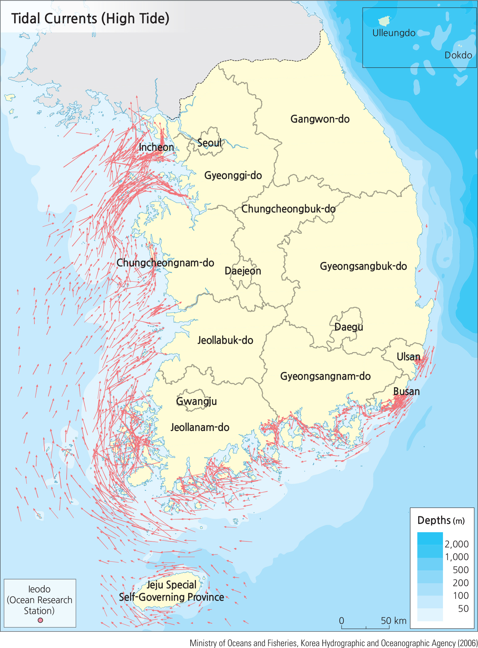
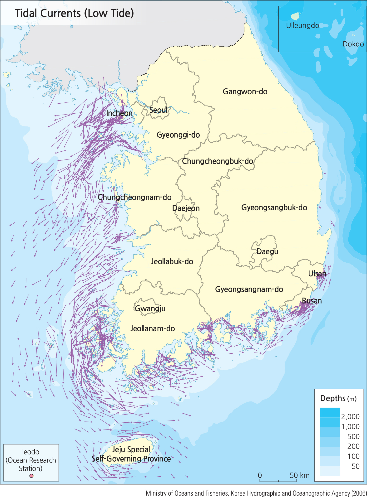
Ocean currents are elusive parts of the environment because at most times they are invisible except when the tide changes or there is a lot of extra sediment runoff from rivers discharging into the sea. In all seasons, the current pattern on the east side of the Korean Peninsula is a counter pattern of a northward warm current from the south and a cold southward current meeting it from the north. In the Yellow Sea the general current pattern is circular in most seasons. The interesting pattern relates to the shape of the Yellow Sea that is bounded on three sides by land. This geographic shape allows a water buildup that creates a strong tidal pattern in contrast to the East Sea on the other side of the Peninsula that has many opportunities for current flows to flow freely with very little tidal range on the south and southeast.
The tide range on the west is quite large with a maximum tide at Incheon of 10.5 m (34 ft), one of the largest in east Asia. At the southeast side of South Korea at Jinhae, the maximum range is 2.3 m (7.5 ft). At Pusan on the southeast side of the Peninsula the maximum range is 1.6 m (5.2 ft). This large range from the northwest side to the southwest side provides the opportunity for the development of tidal power generation. The world's largest operating tidal power station at Shiwa Lake uses a seawall constructed in 1994 near Incheon. Shiwa's mean tidal range is 5.6 m with a spring tide of 7.8 m.
The Shiwa Lake Tidal Station makes use of only the incoming tidal race to generate power. Why would the station only use half of the potential energy stored in the tidal difference? The Shiwa Lake station has a projected life that is continually decreasing. Postulate why this station might be losing power potential. Current scientific investigations project that an area needs a 4-m tidal range to locate an economically viable power station. Estimate where other locations on the west coast of South Korea might be possible for the construction of tidal power stations.