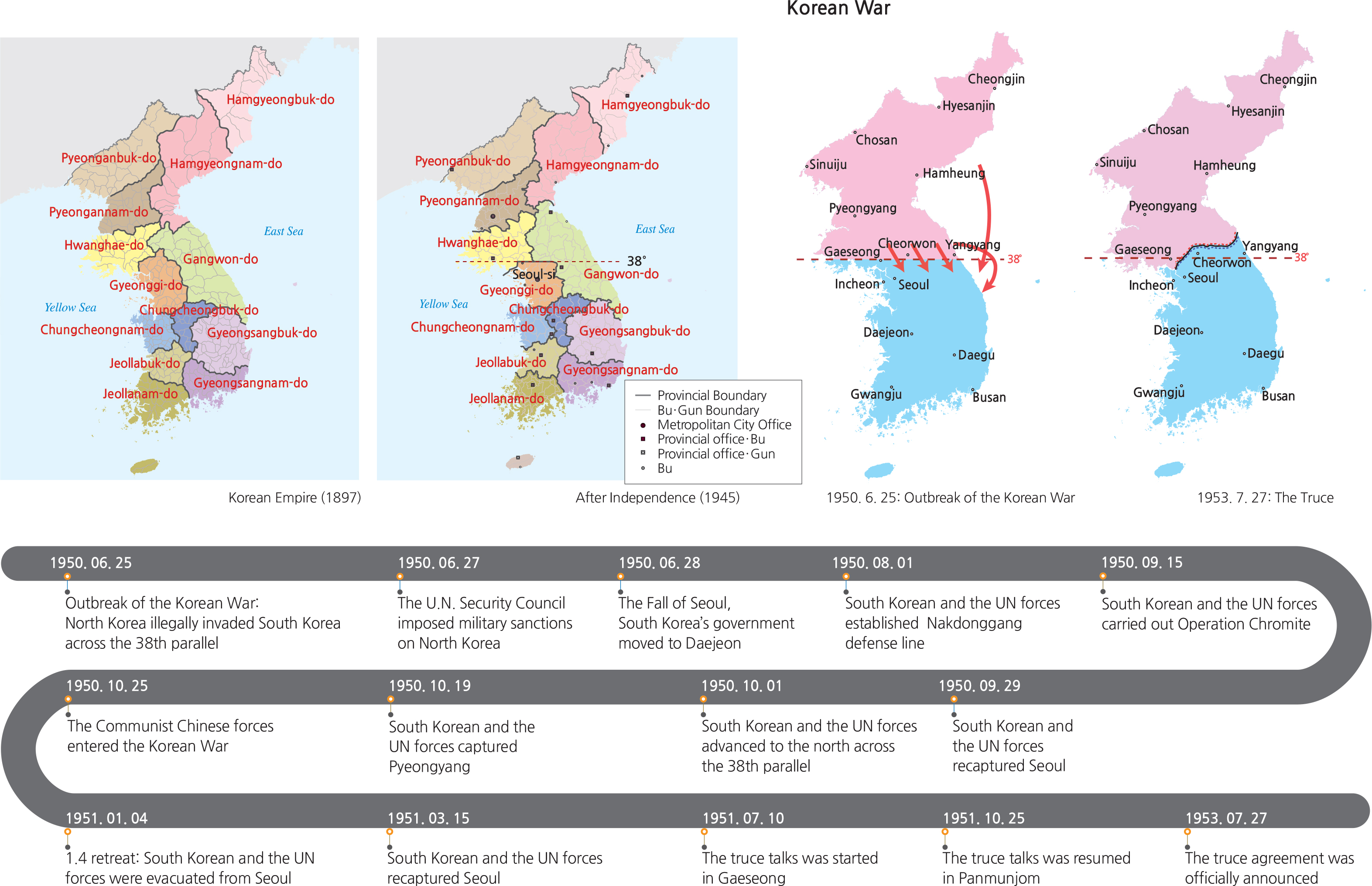
Historically, Korea’ ancient territory included Manchuria and the Korean Peninsula. The first kingdom Gojoseon was formed in 2,333 B.C. and continued for more than two millennia until 108 B.C. Later, tribal nations such as Buyeo, Dongye, Okjeo, and the Three Han States of Mahan, Jinhan, and Byeonhan were established in an era that is generally referred to as the Proto-Three Kingdoms Period. From about 100 B.C. to about 500 A.D., Korean territory still included Manchuria and the whole Korean Peninsula. Buyeo’ location and sphere of influence was mainly centered around Manchuria; Dongye and Okjeo were formed in the northern and central parts of the Korean Peninsula and the Three Han States occupied the central and southern parts of the Korean Peninsula.
From the first century B.C. to the first century A.D. Goguryeo, Baekje, Silla, and Gaya were formed by succeeding and merging tribal nations. This period is referred to as the Three Kingdoms Period when Korea’territory covered Manchuria and the entire Korean Peninsula. Goguryeo encompassed Manchuria and the northern part of the Korean Peninsula; Silla occupied the southern and eastern portion of the Peninsula, and Baekje dominated the southern and western territory. In the 7th century, Silla merged with Goguryeo and Baekje, forming a unified nation in the inner region of the Peninsula, extending from Daedonggang to Wonsanman. In 698 A.D.,Balhae was founded by Goguryeo refugees.
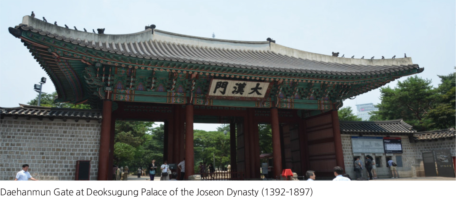
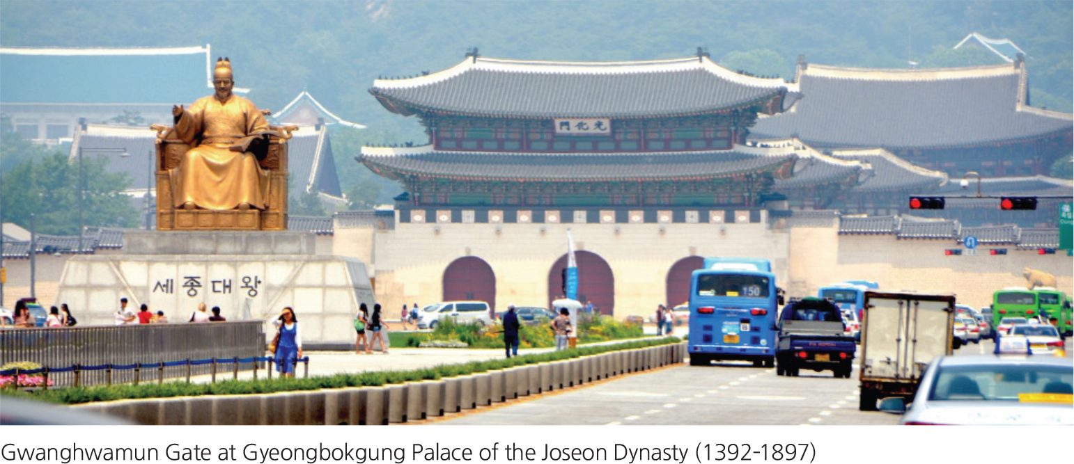
During the Goryeo Dynasty (918–1392) and the Joseon Dynasty (1392–1897), efforts to pioneer and expand the northern territory were made. Goryeo blocked the first invasion from Khitai in 933, confirming its occupation of six coastal provinces (Gangdong Yuk Ju). It started building the Great Wall (Cheolli Jangseong) in 1033, which defined its border with Khitai-Qidan. With the wall, Goryeo recovered its northern territory, which stretched from the present-day city Sinuiju to Hamheung. Its efforts to expand the northern territory continued through the late Goryeo Dynasty into the Joseon Dynasty. As a result, in the 15th century, Joseon installed four forts in the Amnokgang River Basin and six posts in the Dumangang River Basin, which together form North Korea’ current border with China. The combined efforts of the Goryeo and Joseon Dynasties' territorial expansion and protection firmly established Korea's territory of today, which extends from the southern tip of the Peninsula all the way north to the Amnokgang and Dumangang rivers. In the 18th century, the Joseon Dynasty erected Baekdusan National Boundary Monument, marking its border with China’s Qing Dynasty.
The modern and contemporary history of Korea is characterized by the establishment of the Korean Empire (1897–1910), Japanese colonial rule (1910–1945), liberation from Japan (1945), U.S. and Soviet military governments in Korea (1945–1948), and the Korean War (1950–1953). In 1897, in an effort to respond to growing international imperialism, Emperor Gojong officially declared the establishment of the Korean Empire. He then pushed ahead with internal reforms only to witness the temporary loss of Korea’ sovereignty over its own territory when it fell under colonial rule by Japan during its invasion of large areas of East Asia. Japanese colonial rule lasted until 1945. The independence movements for recovering the sovereignty of Korea continued, and the Korean people achieved independence with Japan’ defeat in the Second World War. After the war the national territory was unfortunately divided into North and South along the 38th parallel, a division that became permanent after the North and South governments were established in 1948. Korea then suffered the tragic Korean War, which began on June 25, 1950 and ended three years later with an armistice taking effect on July 27, 1953. Korea’ territory is now divided into North and South by the truce line. Even though the two Koreas have co-existed in a state of truce for 60 years, much of those six decades has been defined by competition and antagonism. Despite these tensions, however, the two Koreas have also made sincere and meaningful efforts to overcome the division with trust-building events such as holding reunions for separated families, inter-Korean summits, and the joint operation of the Gaeseong Industrial Complex immediately north of the DMZ.
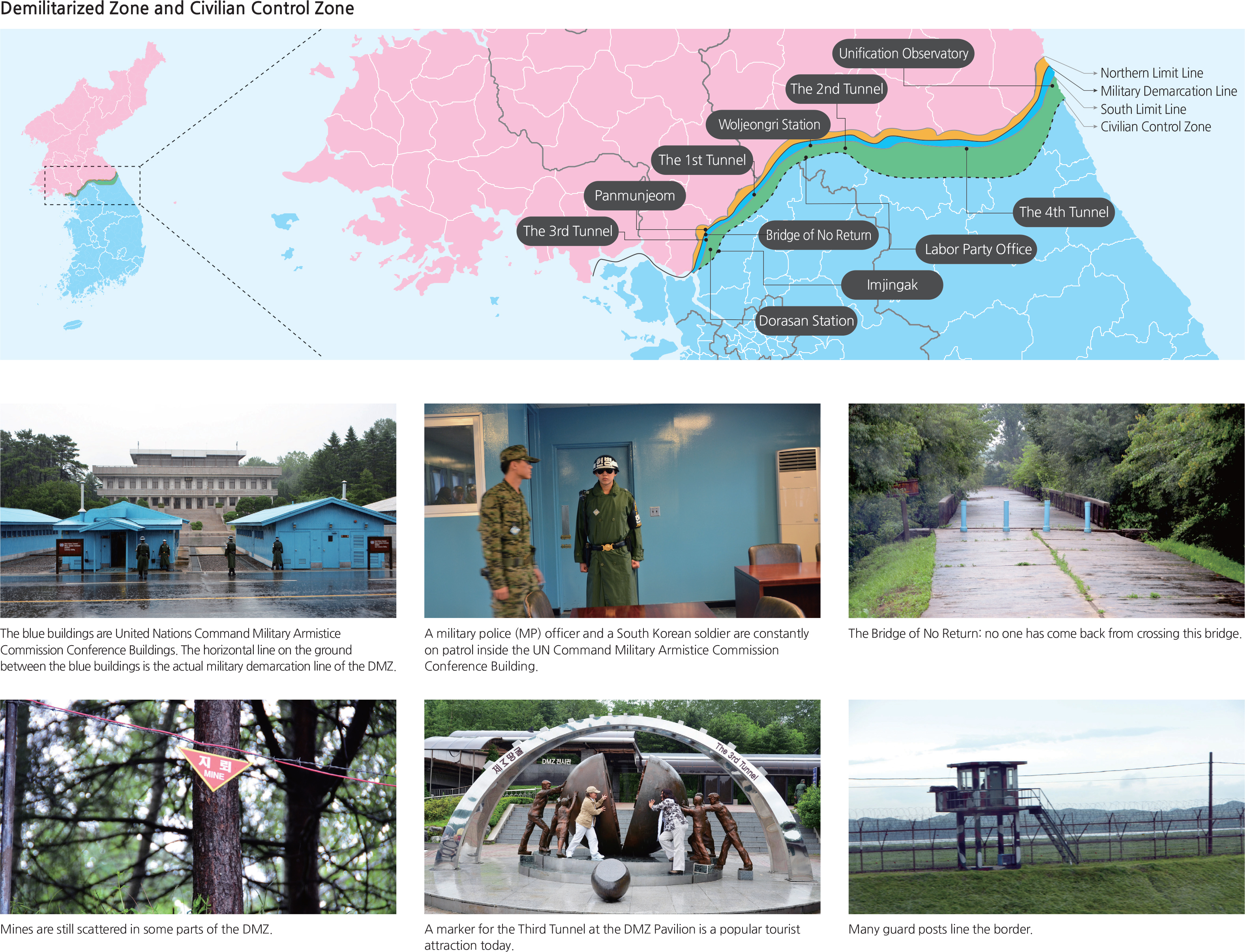
The Demilitarized Zone (DMZ) refers to a buffer zone in which militarization is prohibited. Korea’ DMZ was set up by the ceasefire agreement that put an end to the Korean War. When the agreement was signed in 1953, the military line of contact became the Military Demarcation Line (MDL), and a 4-km wide strip of land, extending 2 km north and 2 km south of the MDL, was designated as the DMZ.
The Civilian Control Zone (CCZ) is a stretch of land that lies between the DMZ and Civilian Control Line (CCL). The CCL is a line designated to restrict public access in the area adjacent to the MDL where the legal protection of military activities is required. The CCL was initially drawn in 1954, and since then three adjustments have been made to reduce the CCZ with mitigations to resolve the infringement of property rights. The current CCL is designated within 10 km south of the MDL. The DMZ and CCZ are areas where human activity is restricted to a minimum, with the exception of farming activities by a few villages along the CCL. Because human activities are limited, these two zones both have diverse natural environments that are well preserved and contain diverse species. Recently, tourism in these areas has become very popular as Koreans and foreign visitors alike have sought to learn more about this well-preserved environment as well as the historic sites that relate to the military activities of the tragic war.
Brief Interpretation of the DMZ Map
The DMZ map shows four sets of lines that define different levels of activities. The Military Demarcation Line is an absolute, rigid line that cannot be crossed by terms of the truce. There are northern limits and southern limits where no build-up of military forces is allowed, except for peace keeping forces. Since there are civilians and farmers who own land close to the southern limit line, the Civilian Control Zone is meant to respect the rights of these owners. The map also indicates locations of tunnels and several important buildings, Panmunjeon (for peace talks), stations for arranged crossings, and a Unification Observatory in the east. The existence of these structures on the map reminds us that tension still exists along the DMZ and that efforts are also underway, albeit in an on-and-off manner, to achieve unification of both sides.
Given the volatility of the situation, do you think that the DMZ is a good buffer to prevent war or are there other diplomatic avenues? Since the truce took place in 1953, military capabilities have changed such that missiles can now fly over the DMZ, is the DMZ today still an effective military buffer zone? There are and were similar barriers in the rest of the world such as the Berlin Wall, the Israeli-Palestinian West Bank Wall, and even the partial U.S.-Mexico Wall, what purpose do they serve that may be different from the purpose of the DMZ?
Expansion of Large Cities
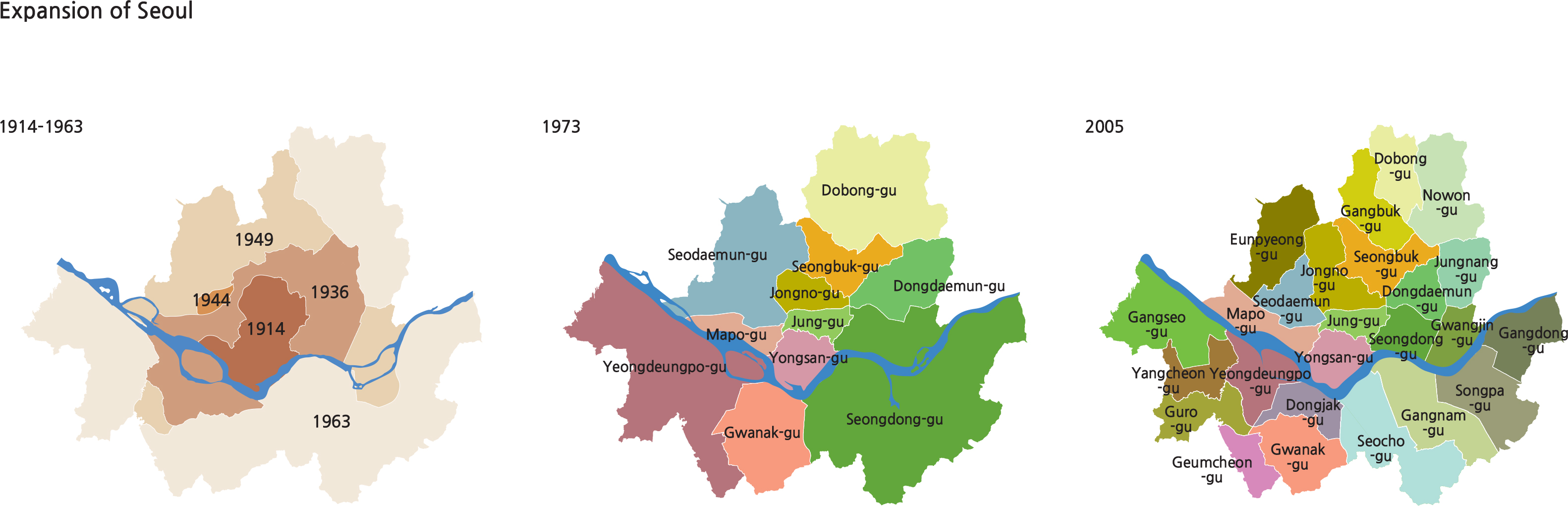
Seoul has experienced a rapid increase in population and area in modern times. During the Joseon Dynasty (1392-1897), Seoul was surrounded by a fortress wall and consisted of Hanseong 5 Bu, its inner districts and outer districts (Seongjeosimni). The outer districts reached approximately 4 km outside the city wall. By the end of the Joseon Dynasty (late 19th century) and extending into Japanese colonial rule (1910–945), the city’ boundaries grew as railroads and streetcar routes were constructed. A massive residential area was built in order to house the Japanese who moved to Korea and farmers who migrated to the city during this time period. By the end of the 19th century, the population of the city hovered above 200,000. Following its liberation from Japan in 1945, Seoul’ population was close to 900,000 and continued growing to 1,700,000 before the Korean War in 1950, when overseas Koreans returned to their country. Seoul’ population increased sharply even before industrialization. Population growth accelerated in concentrated areas of Seoul as industrialization rapidly grew after the 1960s. Such growth led to development on the outskirts of the city as the opening of subways facilitated urban expansion.
In 1963, some parts of Yangju-gun, Gwangju-gun, and Gimpo-gun were incorporated into Seoul, expanding its total land area from 269 square kilometers to 593 square kilometers. The current area of the city is 605 square kilometers, as some parts of Siheung-gun and Goyang-gun were incorporated into Seoul in 1973. As Seoul expanded, the number of administrative districts also increased. In 1943, there were seven ‘u’ (districts), and because the administrative divisions were reorganized, the number of ‘u’ has grown to 25.
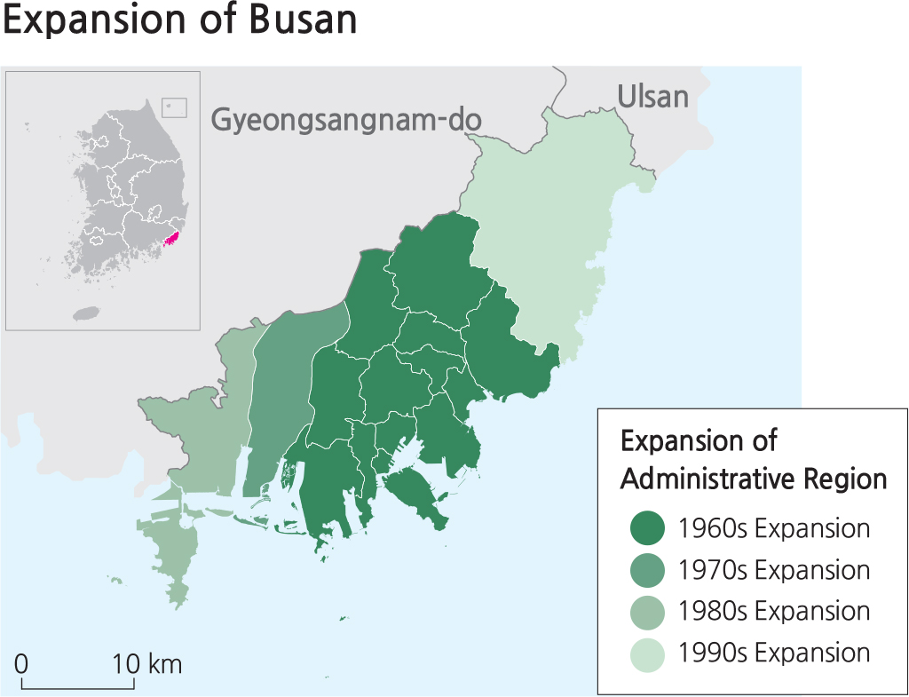
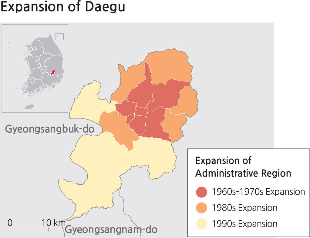
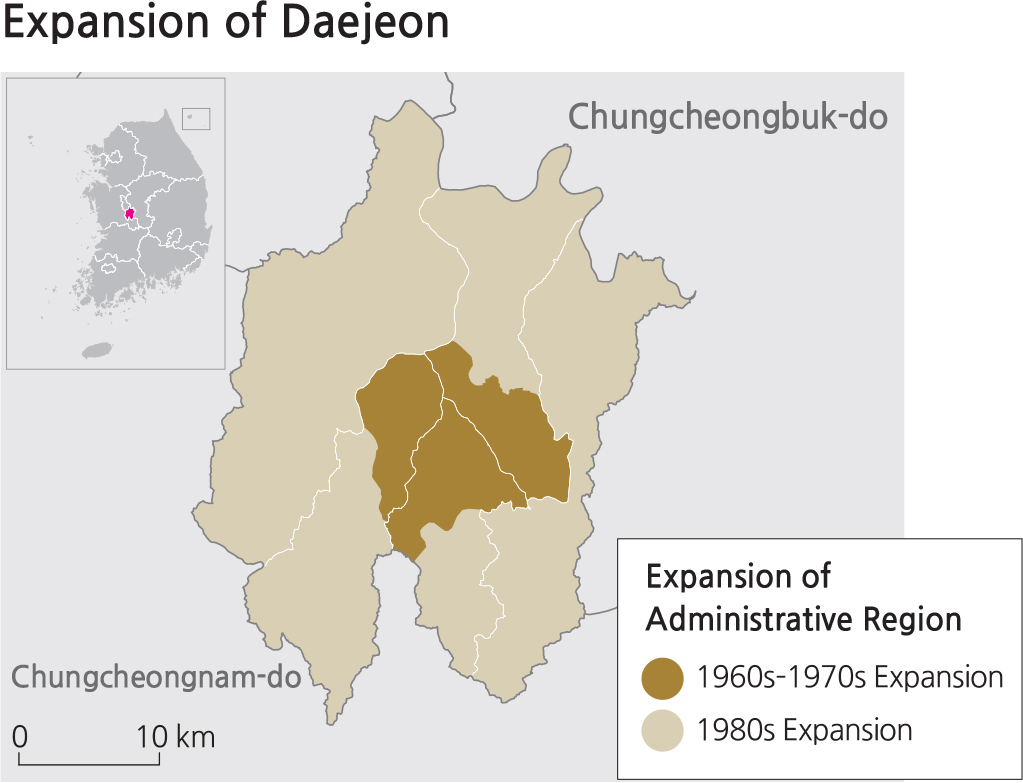
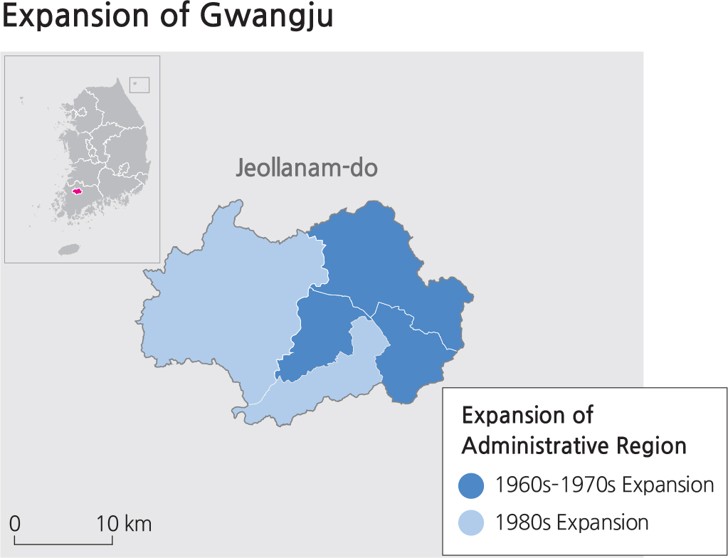
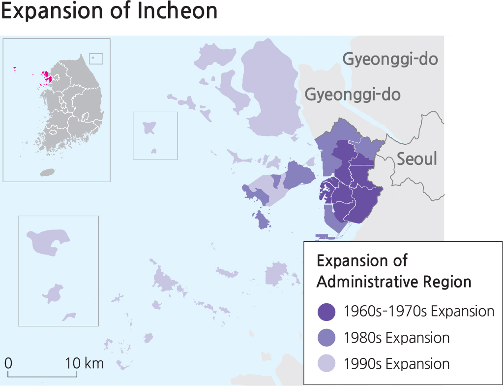
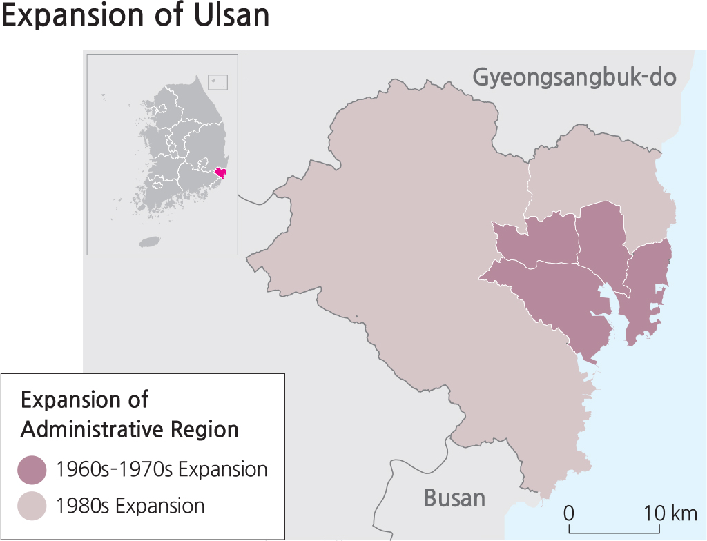
Like Seoul, six other cities have large increases in population and have expanded areas to be incorporated as Metropolitan Cities in Korea’ administrative system; as such, each Metropolitan City is no longer under the jurisdiction of the province in which it is located. The port and harbor facilities in Busan serve international shipping logistics. Daegu incorporated several neighboring ‘un’, as did Incheon, the gateway city into Seoul. Today, Incheon, with its vast amount of reclaimed land, has evolved into an international hub with its busy airport and financial zones. Both Gwangju and Daejeon followed the path of urban expansion by incorporating neighboring ‘un’ (counties). Thanks to its industrial complex, which includes the Hyundai Automobile plant, Ulsan became the 6th Metropolitan City in 1997, two years after the first five. These six cities are thriving urban centers today and have been targets of population migration for the past two decades. Large housing projects, along with the necessary services such as schools, hospitals, cultural facilities, playgrounds, green spaces, and other infrastructure, were also built to meet the needs of the rapid population increase.
Brief Interpretation of the Maps
The set of time series maps depicting the expansion stages of Seoul clearly shows the increase in the number of ‘u’. Each of the large area ‘u’ on the outskirts of Seoul had to be broken up into several small area ‘u’ due to population increase. Notice also that the shape of the Han River has changed over time due to reclamation along the river banks to create more land in the central areas of Seoul for important building projects. The spatial expansion of six Metropolitan Cities is also expressed in map form. In all six cases, expansion starts from the inner core and expand outwards towards their peripheral land areas.
The outer boundary of Seoul has remained the same since 1963, what has happened to its population density since then? What are some ways to ease congestion in Seoul? Should the government provide incentives for people to move elsewhere on a voluntary basis? Will building more high-rise residential housing be a permanent or sustainable solution? Discuss the possibilities and implications of creating attractive jobs elsewhere.
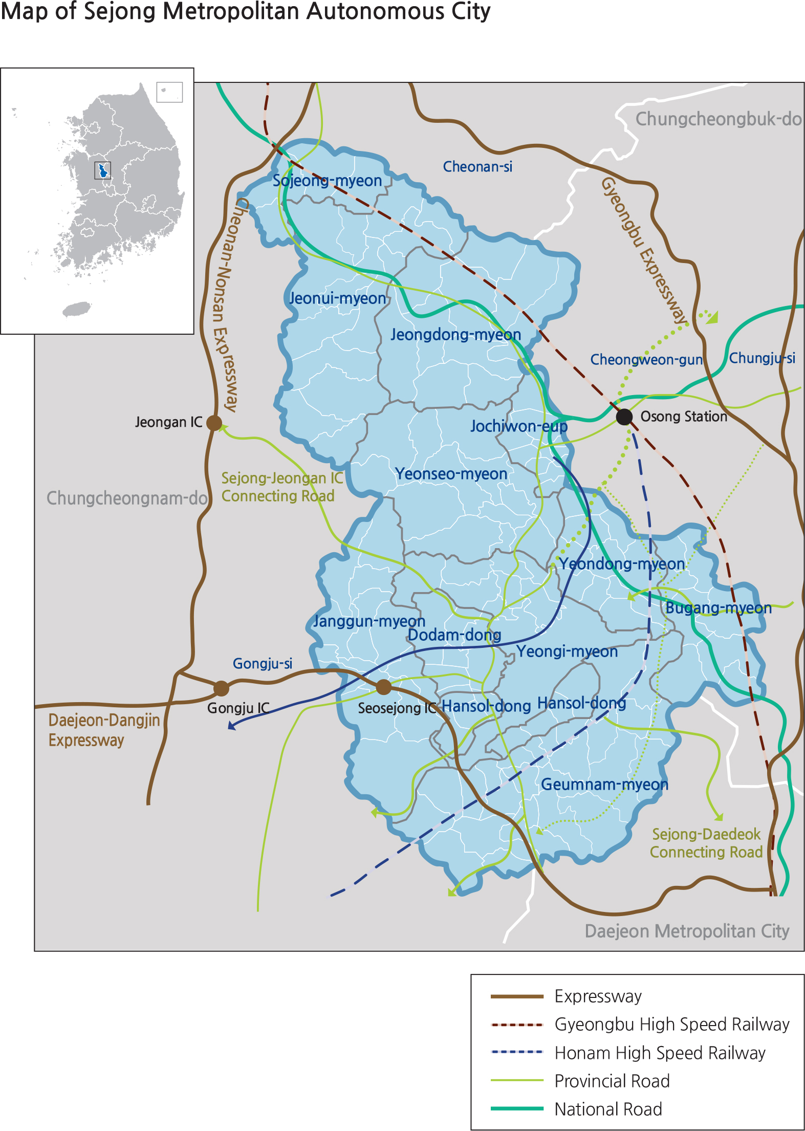
A Special Administration Region Sejong Metropolitan Autonomous City
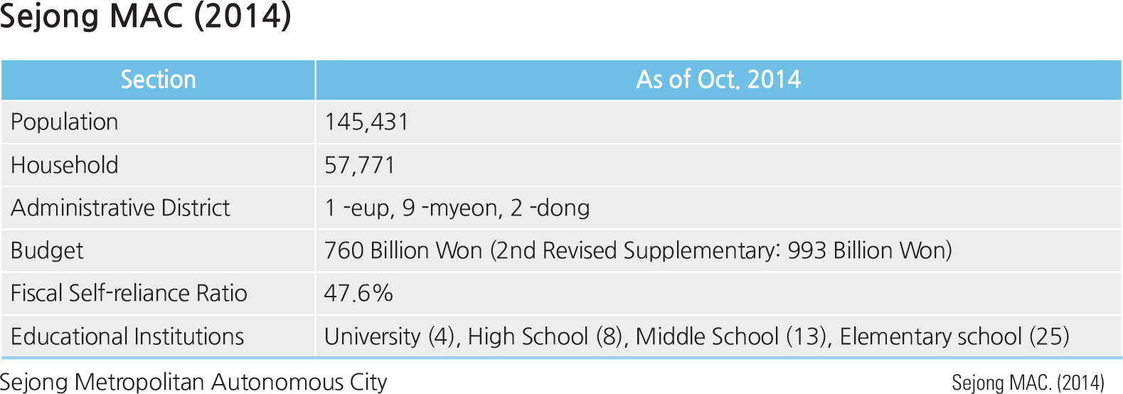
As rapid urbanization continues, Korea is realizing increasingly unbalanced development between regions as well as a high degree of concentration of governmental functions in one single city. The need for spatial diversification is clear. As early as the late 1970s, then-President Park Chung-hee developed plans to relocate the capital city to the Gongju area because Seoul was considered too close to the North Korean border. After some political decisions that involved interpretation of the Korean Constitution, a new city named Sejong was built from scratch in 2006 to house many of the government’ ministries. By 2012, Sejong became part of the nation’ administrative system as Sejong Metropolitan Autonomous City. By the end of 2014, 16 central government branches, 19 governmentrelated organizations, and 14 national research and development institutes moved to the city. Large numbers of government workers had to move to Sejong from Seoul. The population is expected to increase from 145,431 in 2014 to about 800,000 by 2030. Brand new high rise residential buildings were constructed to house the city’ in-migrants. All other supportive services such as schools, hospitals, food services, a police force, and a firefighting force were also created. Careful spatial planning took place to insure that the city would be well structured to deliver efficient functionality for the central government. While Sejong officially serves as a multifunctional administrative city, some argue that it has the potential to become the future capital of the Republic of Korea.
Brief Interpretation of the Maps
For the map of Sejong City, the city limit is clearly shown, as are major roads and expressways. New cities are established, planned, and grow differently than old cities that evolve or grow over time. For the identification of new buildings and construction, a satellite image should also be consulted to get the broad range of geographic features that are incorporated in a new city.
Considering Sejong is a new city, why is Osong Station in the map of Sejong City,,located at the convergence of two high speed railway lines for bullet trains that can travel at 180 miles per hour, outside the city limits? What does it take to build a brand new city from scratch? What considerations must be taken into account? What environmentally-friendly facilities should be included?
Special Administrative Region: Jeju
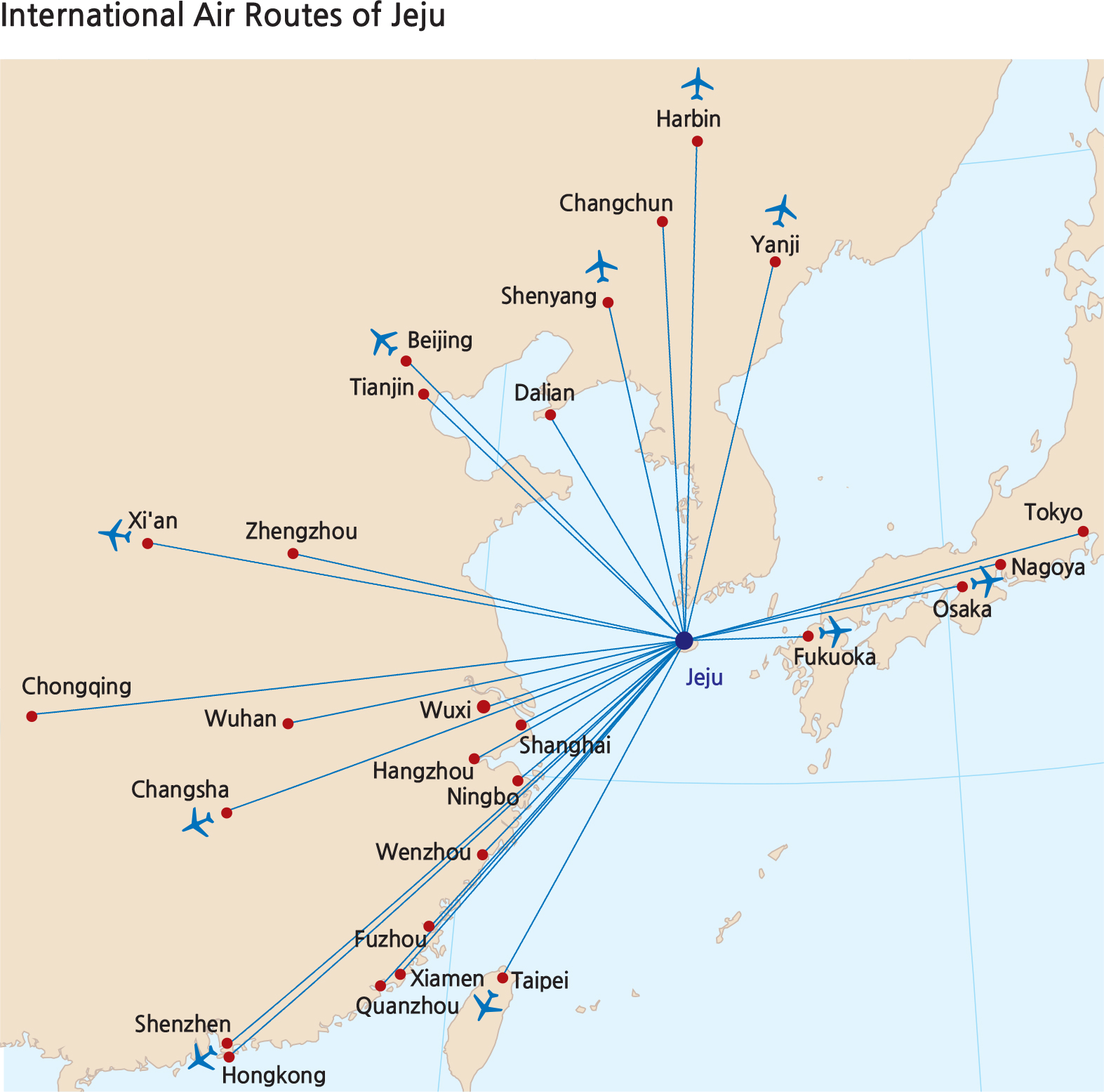
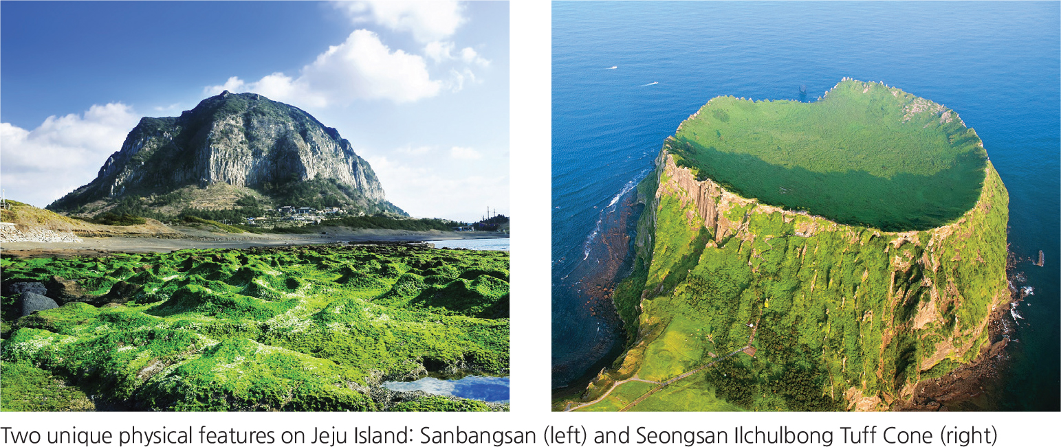
Jeju is the largest island in Korea and is known for its beautiful natural landscape and unique cultural heritage; these attributes attract large numbers of tourists. Jeju Island was created from volcanic activity and is characterized by a volcanic topography, such as Hallasan, numerous parasitic cones, and caves. Because of the unique ecological and environmental value of Jeju, the island was designated as an UNESCO Biosphere Reserve in 2002 and as a World Natural Heritage Site in 2007. Jeju was also certified as a Global Geopark in 2010.
Well-preserved natural environment and a unique ecosystem made Jeju an ideal location for various leisure and recreational facilities. The island becomes a well-known international tourist destination. Because numerous international and domestic tourists visit the island every year, the Seoul (Gimpo)-Jeju airline route is one of the busiest air routes in the world.
Jeju became the first Special Self-Governing Province in 2006 with the goal of facilitating regional development that focuses upon unique regional attributes. There is also a plan to build an international city to facilitate free trade. Unlike any other provinces, the Jeju Special Self-Governing Province belongs to a category that has a high level of guaranteed autonomy. Specifically, with autonomous decisions to implement administrative deregulation and the bold introduction of international standards, the island is now attracting foreign visitors, investors, and immigrants, thus ensuring free enterprise. After becoming a Special Self-Governing Province, Jeju has seen foreign investment increase, and many foreign educational institutes have been established here due to streamlined regulations.