The Korean Peninsula is located between 33˚ and 43˚ north latitude in a temperate climate region with four seasons. Precipitation in Korea is abundant, and each season produces diverse climatic characteristics across the peninsula. In South Korea, mountain areas, which are mostly distributed around the northern and eastern regions, cover about 64% of the land. In the southern and western areas where large rivers run, various erosional or depositional landforms surround the rivers. Three sides of the Peninsula are surrounded by the sea with a ria-filled
coast and many islands along the south coast; even and flat tideland resulting from a vast tidal range on the west coast; and sand dunes and lagoons alongside a smooth coastline in the East Sea.
The complexity and variety of ecosystems formed by the diverse climate and complicated topography affect the biodiversity which inhabits the Peninsula. Sub-alpine coniferous forests are common in the northern region, deciduous broadleaf forests are common in the central region, and warm, temperate evergreen forests are common in the southern and island regions. The natural conditions and variety of vegetation also create variations in ecosystem productivity, resulting in distinct micro-habitats for a wide diversity of faunal communities.
The rich and diverse ecosystems in the Korean Peninsula have attracted people for centuries. The people of Korea have been provided with abundant ecosystem services. They have developed a unique lifestyle that merges the marine culture of the Pacific with the continental culture of Eurasia. They have also established a watershed-based traditional view of nature with the Baekdudaegan Mountain Ridge as the backbone of the Peninsula, and have developed numerous unique ecological cultures such as village forest, acorn jello, Songgye (traditional social institution for sustainable forest management), and Hyangyak (local rules). Although the rapid industrialization and land development has expanded the national economy, Korea now faces significant environmental issues such as pollution of air, water, and soil, reduction of biodiversity, and ecosystem degradation.
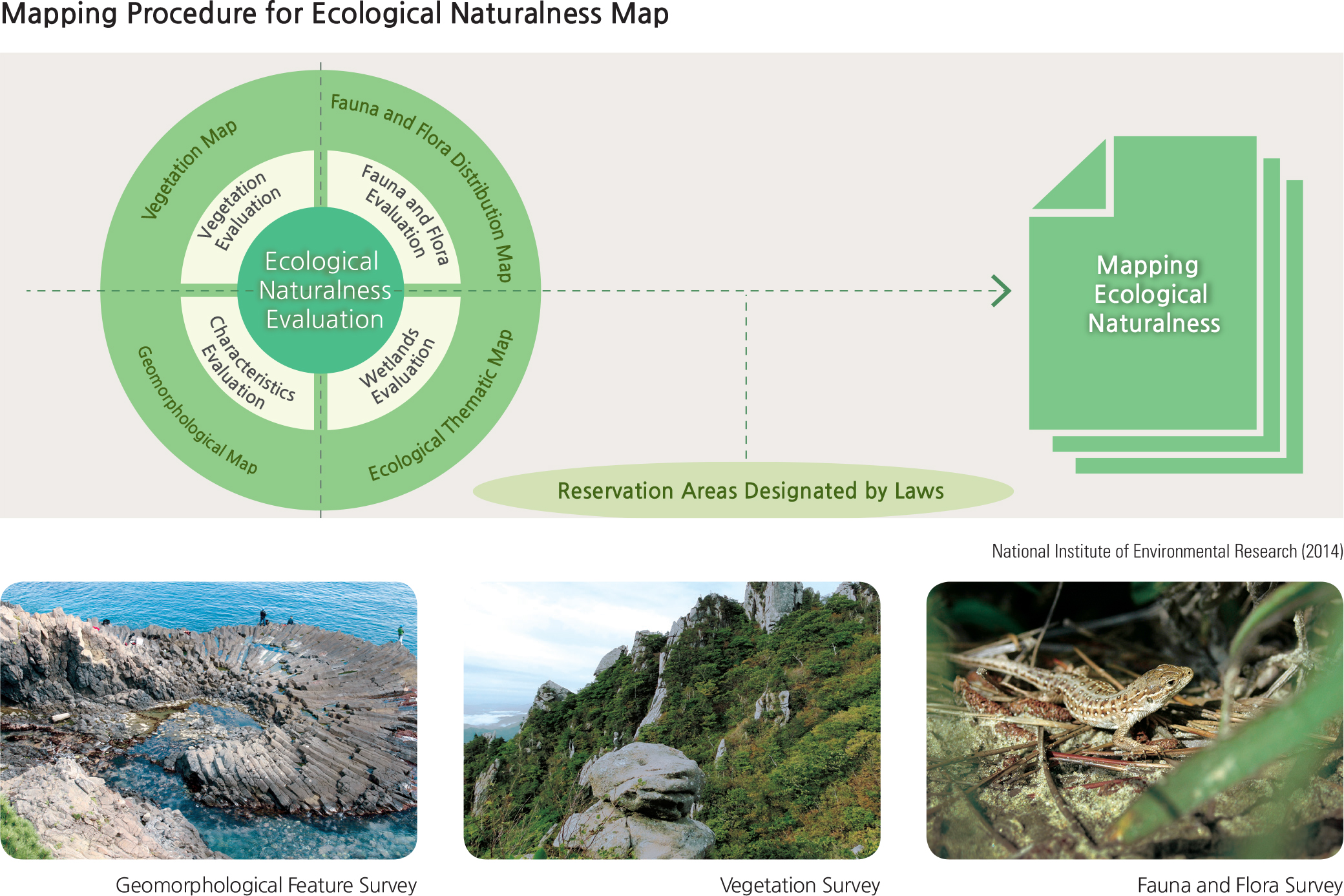
To take action against these issues, natural environments and biota have been studied vigorously and mapped nationwide. The Ministry of Environment has been conducting a nationwide survey of the natural environment every five years. The first Natural Environment Survey started in 1986. Since 2014, the 4th survey has been carried out. The produced maps range from thematic maps such as valuable geomorphologic feature maps, vegetation maps, floral and faunal distribution maps, and comprehensive environmental evaluation maps. They are now publicized and widely consulted by various users such as environmentrelated governmental agencies, industries, academics, and the public.
The collected data have been comprehensively assessed and used for the formation of Ecological Naturalness Maps. Ecological Naturalness Maps visualize the ecological value of each spatial feature—mountains, rivers, inland wetlands, lakes, farmland, and urban areas—according to a specifically-derived rating system.
For the Ecological Naturalness Maps, environmental investigations are carried out to evaluate ecological naturalness through field surveys under nine categories (geographical features, vegetation, flora, benthic macro-invertebrates, insects, freshwater fish, reptiles, birds, and mammals). The results are stored in a GIS database. Based on these data, assessments of vegetation, animals and plants, geographical features, and wetlands are carried out for the comprehensive evaluation of the Ecological Naturalness Maps.
Final results are illustrated on the maps according to a 4-Grade ranking system. In Grade 1 areas, the highest grade, development activities are limited in order to preserve or restore the natural environment. In Grade 2 areas, measures are required to minimize impacts on the natural environment due to development and land use. In Grade 3 areas, systematic development and land use are permitted. National parks and cultural heritage protection sites are designated as reservation areas by laws such as the Natural Environment Conservation Act. They are classified as Special Management Areas. Grade 4 areas represent the least amount of preservation value.
Ecological Naturalness Maps are used in national and local environmental plans, as well as in the process of making and implementing development plans, environmental impact assessments, and in consultations requiring referential data.
Brief Interpretation of the Map
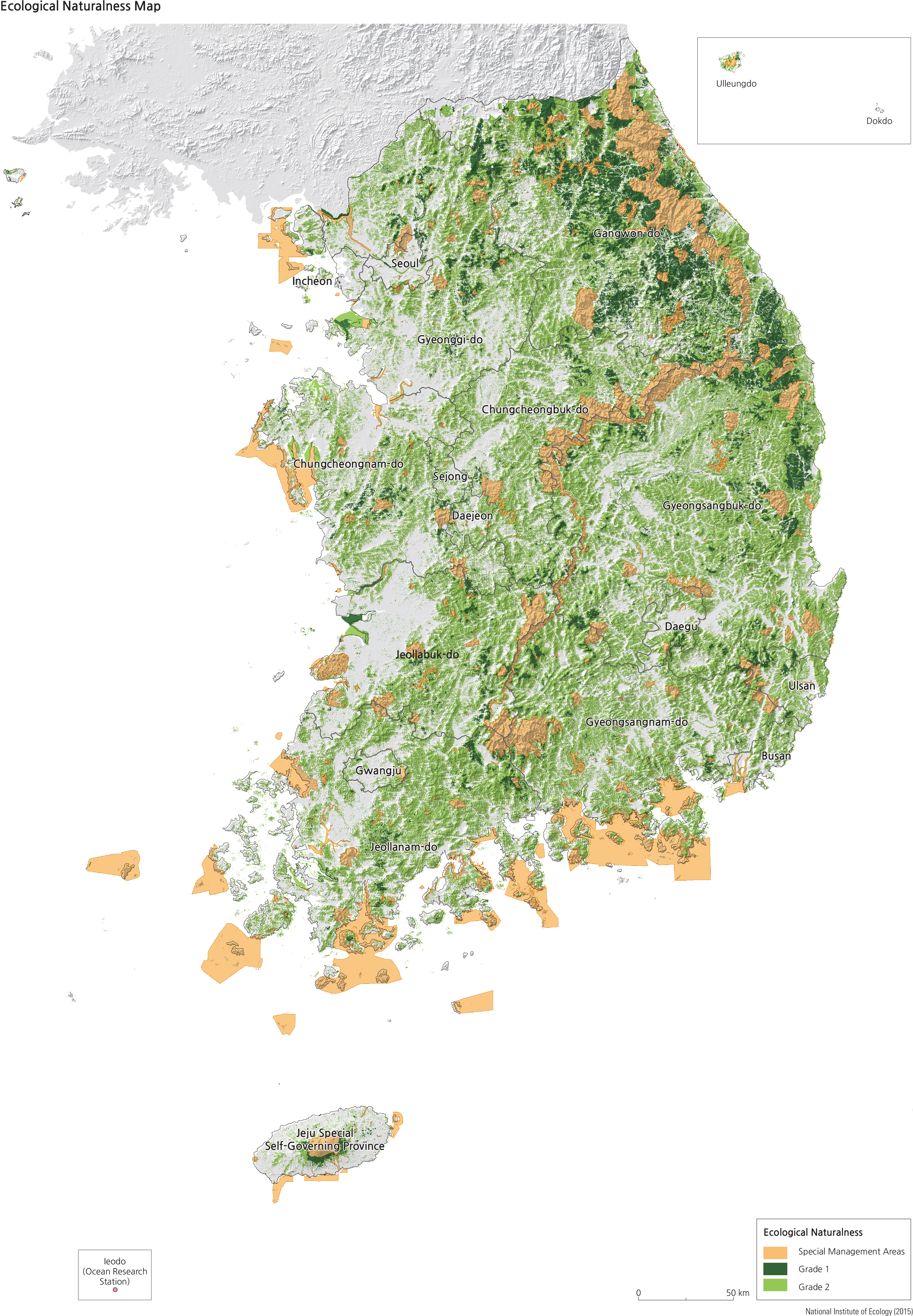
The Ecological Naturalness Map displays areas of special concern for development sensitivity. National Parks and other special reservation areas are shown in orange and are concentrated in coastal areas and along mountain ranges
in the north-central area of South Korea. Grade 1 areas with limited development tend to be also in mountainous areas and concentrated in the north adjacent to Special Management Areas. Other Grade 1 zones are small and scattered in other high terrain areas. In Grade 2 areas, development measures are required to minimize impacts on the natural environment. The Grade 2 areas comprise by far the largest category and encompass most of the rest of the country of every elevation excluding valleys, agricultural areas and urban areas.
This map shows over 80% of South Korea is covered by Grade 2 or better areas of ecological and environmental developmental concern. With this degree of sensitivity, one wonders how much more of the land area of South Korea can tolerate further development of any type or how new development needs to be tailored to protect the environment.
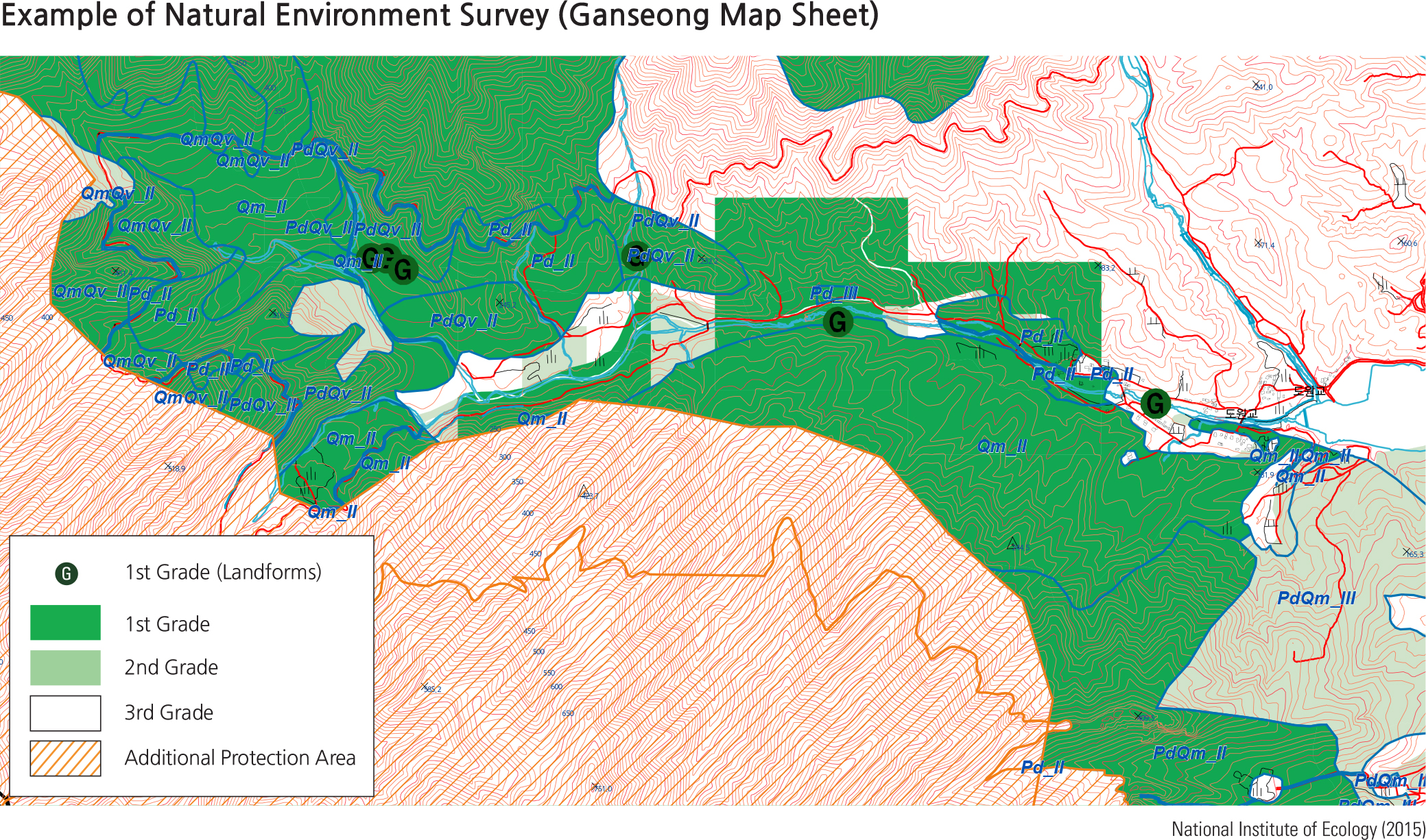
The Natural Environment Survey map on page 122 shows a Grade 1 (limited development activities) boundary. Part of the boundary suggests a natural boundary (roughly following a terrain elevation) and another part of straight line segments indicating a human defined administrative boundary. Does the variable nature of a composite boundary of this type require variable rules for protection steps as well? With the Grade 2 designation covering over 50% of South Korea, how effective do you think restrictions of the Grade 2 classification are in protecting the environment? Discuss if the Grade 2 classification might be too broad, given how expansive it is in areal coverage? Do you think the Grade 2 classification requires new protection rules? Should the Grade 2 category be divided into two or more classifications, to more accurately define ecological sensitivities of different areas?