Introduction
The term “hysical Settings”encompasses everything that occurs in nature without human intervention. The National Atlas of Korea addresses such physical settings on the Korean Peninsula as the actions of the lithosphere, the biosphere, the atmosphere, and the hydrosphere. But because humans live on the land and have a great deal of interactions with these physical “pheres,”scientists identify a special sphere called anthroposphere. The term “nthropo”refers to “ertaining to humans.”The lithosphere includes the study of landforms, geology, rocks, minerals, and soils. The biosphere refers to the realm of all living things, including all classifications of plants and animals. The atmosphere encompasses all studies relating to the composition of the air around our planet, how it moves, and how weather and climates interact with the sun’ energy and the locations of elements on the surface of the earth. The hydrosphere pertains to the water systems on our planet, including tthe seas and oceans, arctic and alpine snow and ice, as well as inland water systems in rivers, lakes, and underground aquifers.
This section introduces landforms in the lithosphere, the atmosphere, and the hydrosphere. More detailed discussions of the biosphere can be found in The National Atlas of Korea Vol. II. For the introduction of the anthroposphere, discussions shall center on the human-environment interactions on the Korean Peninsula as well as factors of climate change. Chapter 4 introduces the anthroposphere and human interaction with the natural spheres and the environment on the Korean Peninsula.
Landforms
The Korean Peninsula has long coastlines for its size. In contrast to its smooth eastern coastline, its southern and western coastlines are extremely complex with a great deal of indentations and offshore islands. According to a 2014 survey, the total coastline of the mainland is 7,753 km while the coastlines of Korea’ associated islands constitute 7,210 km. Artificial coastlines resulting from land reclamations for coastal development and port construction have reached 5,086 km.
One of the most significant geographic characteristics of the Korean Peninsula is its prominent NNW-SSE oriented mountain ranges: Nangrimsanmaek (Nangrim Mountain Range) and Taebaeksanmaek (Taebaek Mountain Range). The term “anmaek”translates literally as “ountain arterials”or figuratively as mountain chains. These mountain ranges resulted from the formation of a back-arc basin on the edge of the Asian continent, a process that also produced the Hamgyeongsanmaek (Hamgyeong Mountain Range) and the Sikhote Aline Mountain Range in Russia. The Ulleung Basin, located in the East Sea, was formed as a result of the Taebaeksanmaek uplift.
High mountains are asymmetrically located to the east and north of the Peninsula, following the ranges of Taebaeksanmaek, Nangrimsanmaek, and Hamgyeongsanmaek. The last two ranges contain the highest peaks that stand above 2,000 m: Dojeongsan, Kwanmobong, and Duryusan of Hamgyeongsanmaek and Heesaekbong, Maengbusan, and Nangrimsan of Nangrimsanmaek. On the other hand, Taebaeksanmaek – which runs 500 km from Youngheung Bay in North Korea along the east coast to Busan in South Korea –has much lower elevations. Major mountains in this range such as Geumgangsan, Seoraksan, and Odaesan are about 1,500 – 1,700 m high.
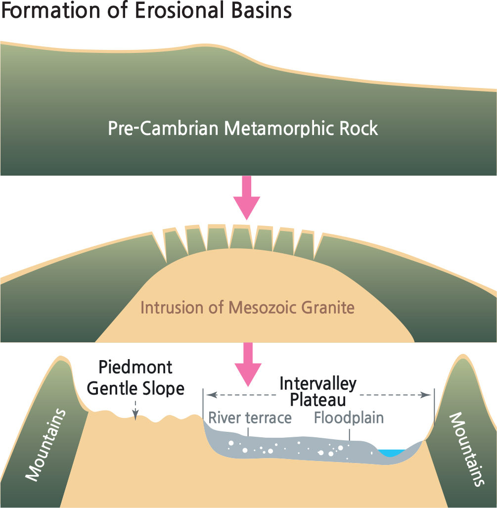
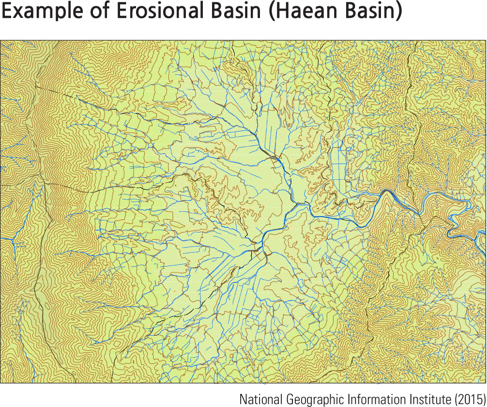
Toward the southern part of the Peninsula, granite is distributed in circular or girdle-shaped areas between metamorphic rocks. Well-developed erosional basins formed on the granite provide gentle slopes of 1 –10 ̊that are located between steep mountains and at plains to enable major transportation routes to pass, including a high speed railroad. In geographic analysis, this is a typical human-land interaction as physical geography dictates the landscape while humans adapt to its use.
Because Taebaeksanmaek and Hamgyeonsanmaek are located in the eastern region of the Korean Peninsula, most large rivers flow southwest from the major watersheds defined by the mountain ranges. Meanwhile, streams that lead into the East Sea on the steeper eastern slopes of the ranges are shorter. This disparity is a central characteristic of rivers on the Korean Peninsula. Due to the Peninsula’ relatively high average slope and significant seasonal difference in precipitation, Korean rivers are also characterized by a high coefficient of river regime, meaning
that there is great variability in water flow during the year. Furthermore, most rivers display wide valleys and gentle gradients.
The traditional Korean geographical portrayal of mountain ridges is to use lines to express the intertwined relationship between major mountains. Mountain ridge maps help us visualize the geographical unity of the Korean Peninsula by emphasizing that mountain systems are interconnected just as rivers are continuous. These maps specifically demarcate high peaks and mountain ridges, recognizing their importance as connecting passageways between living spheres and ridges. Even without modern scientific explanations of geological structures, terrain formation, and landscape changes, traditional geography emphasized watershed systems to differentiate human settlement areas. The Baekdudaegan is a traditional delineation of a firstorder ridgeline that joins Baekdusan, a volcanic crater in the North Korea-China border, to Jirisan in the southern part of South Korea –the highest peak in mainland South Korea. The Baekdudaegan map provides a sense of unity and order throughout the Peninsula and helps to secure the national symbolism of Baekdusan. The full uninterrupted illustration of the watershed further helps to identify rivers and mountain ridges more easily. In summary, Korean traditional geography is beneficial for the efficient development and usage of the mountainous terrain and understanding Korean geomorphological features through the lens of Pungsu (Korea word for fung shui or geomancy). Making up a large proportion of the Korean Peninsula, mountainous regions and their complex distributions are mapped in multiple ways. There are three main methods that are currently being used to represent mountain distribution: the mountain range map, the mountain ridge map, and the mountain chain map.
Mountain range maps classify mountains based on the premise that mountain ranges display characteristics of the nation’ geological history and tectonic movements. On the other hand, the mountain ridge system of Baekdudaegan resembles the watershed dividing lines of the ten main river basins in Korea and reflects the connectivity of the mountains. Understanding mountains based on river
basins is a unique way of geographically visualizing the indigenous nature of Korea.
Brief Interpretation of the Maps
The terrain pattern on the opposite page map is much more detailed than what was shown on the general map of Korea on pages 24-25. This detail creates a significantly different picture of the land than when it was combined with the cultural detail, especially given the information of the profile transects that run in NS and EW directions.
A very small element of the western coastline of the Korean Peninsula shows the landform changes created by the inhabitants of the cities. There are thin, dark blue lines that extend into the Yellow Sea. These are a series of seawalls that have been created to begin the process of reclaiming coastal sea areas into land for urban and agricultural development. The current lines in the ocean surround areas that are already significantly reclaimed in some areas. In the coastal areas of Incheon, the reclaimed land between the islands of Yeongjong and Yongyi is already in use as Incheon International Airport, one of the world's busiest airports that was ranked many times as the world's best. Over 180 km south of Seoul is the Saemangeum Seawall project, easily visible on the Landform map. This project in development for industrial and agricultural land is one of the world’ largest reclamation projects and a controversial one for the loss of a large area of natural wetland habitat for sea birds and other species.
The three maps below are traditional Korean ways of visualizing mountains based on mountain ranges, mountain ridges, and mountain chains. These are people’ perceptions of the land and the existence of the mountain systems. The maps are somewhat stylized as represented by lines. They help to provide images of the forms and directions of the mountains in an easily recognizable mental capacity. They also help to classify the order of the mountain ranges and chains.
Look closely at the southwest and south coasts of Korea and project how much more land could be added to agricultural production in South Korea by similar reclamation projects. How would adding more projects of the size of the Saemangeum project affect the economy and environment of South Korea? How would these projects compare to the historical reclamation projects of the Netherlands, especially in the type of land now in the sea?
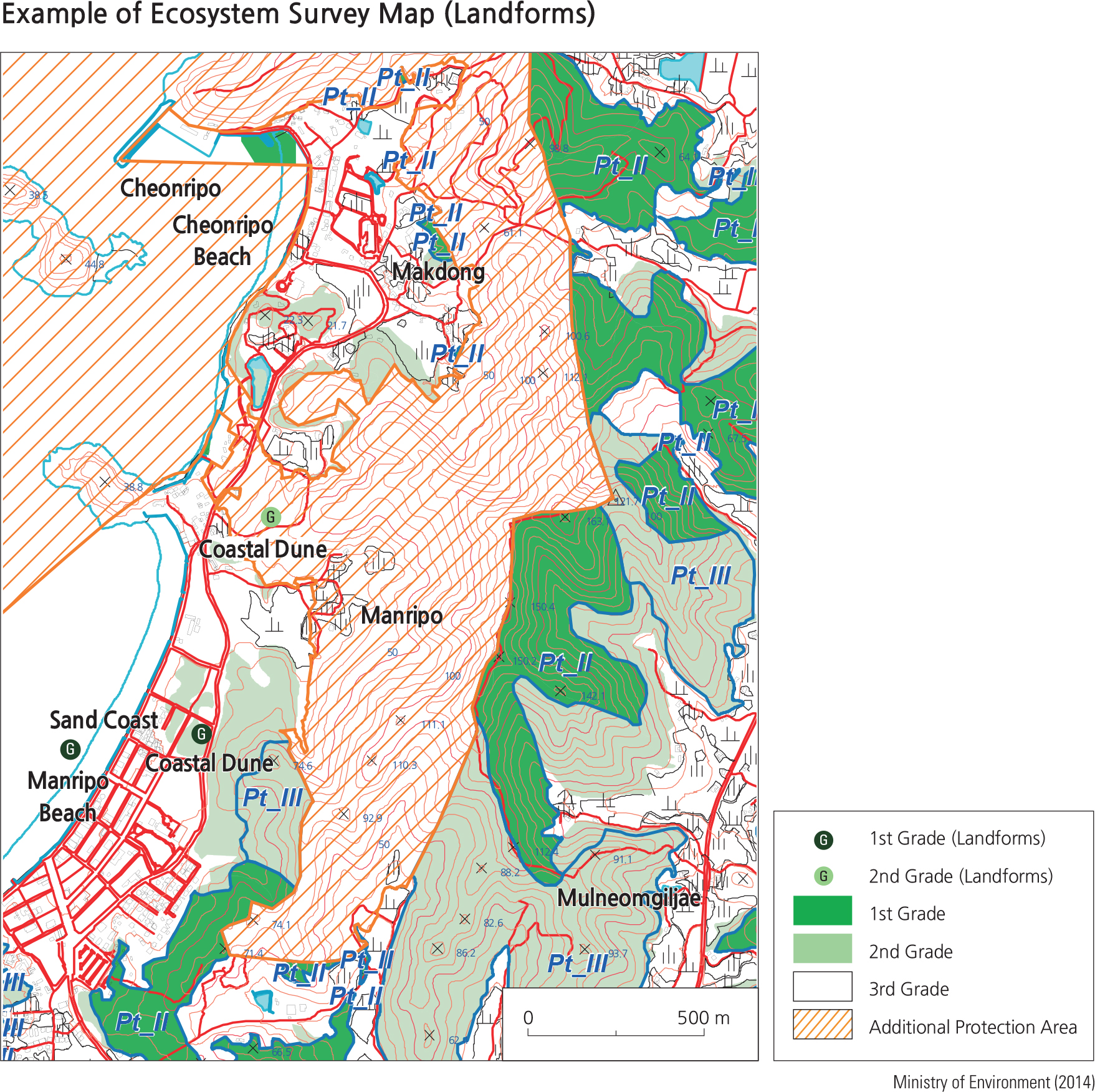
Korea conducts a national ecosystem survey that inspects the comprehensive status of the natural environment. It covers abiotic components (topography, geology, land, and soil) as well as biotic components (plants and animals). This survey enhances the understanding of topological features, the distribution of plant and animal species, the level of environmental destruction, conservational value, and so on, by analyzing the characteristics of each individual element.
The National Ecosystem Survey has three components: first, a comprehensive national environment survey as a basic investigation for the natural environment; second, a targeted survey of key ecological landscapes that include inland wetlands, uninhabited islands, coastal sand dunes, estuaries, and other landscapes of outstanding ecological importance; and lastly, a species survey on legally protected, rare, and endangered wild flora and fauna. This survey is the largest scale of its kind conducted annually in Korea, involving around 500 researchers in various fields including landforms and taxonomic groups of plant and animal species. The nation’ very first survey (1986 to 1990) covered terrestrial, freshwater, and coastal ecosystems and was based on the basic plan for the national ecosystem survey (1986. Feb. 24). The landform survey was included in the second-phase survey (1997 to 2003) and has been continuously updated ever since the third survey (2006 to 2012).
Evaluation of all environmental features is based on a general grading system. By law, Grade 1 features have the highest preservation value and are to be protected at all times. Lower level grades decrease accordingly in preservation value.
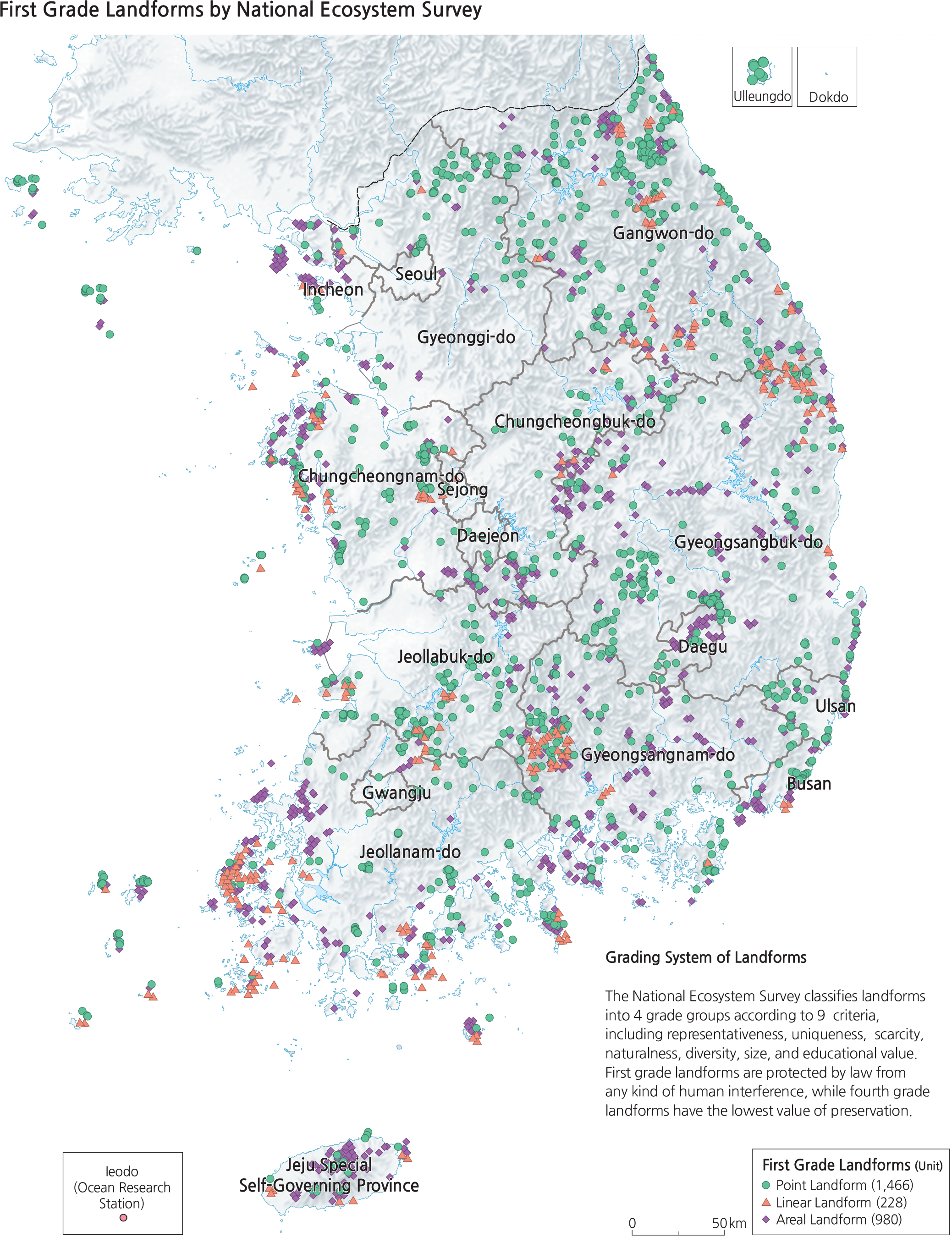
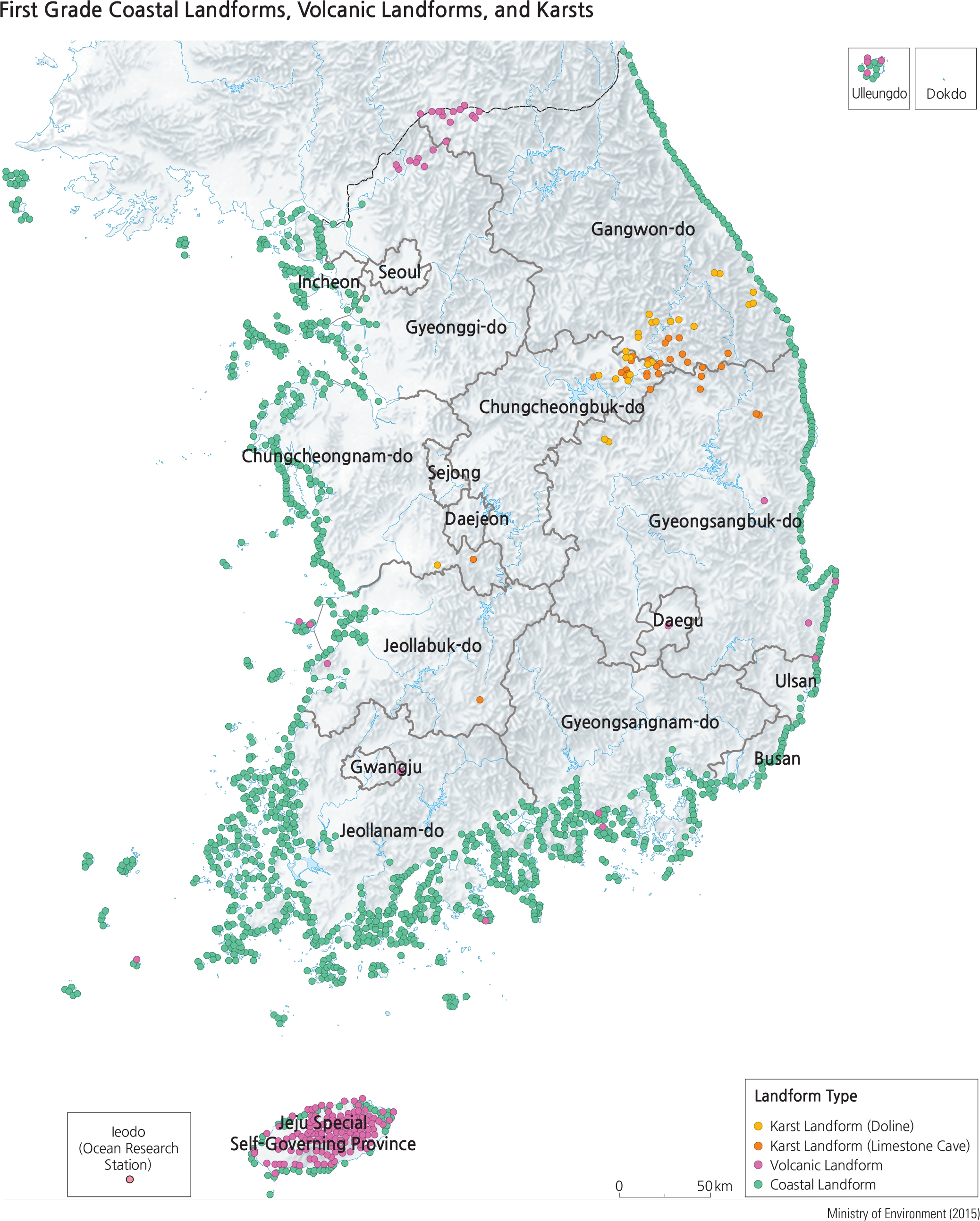
Geomorphology is the study of landforms, particularly their formations, changing forms through erosion and deposition. Geomorphic and landscape features are some of the most fundamental components of the natural ecosystem. Topographic features directly influence surface geology, soil distribution, ground water status, and growth and reproduction of plant and animal species. The national landform survey is composed of two different surveys: one is a general survey of features such as mountains, river landforms, and coastal landforms; the other is a special survey of volcanic and karst landforms. The results of the topographic survey are categorized into points, lines, and polygons based on their attributes. The third phase survey has reported that valuable topographic features of the first grade comprise 1,446 points, 228 lines, and 980 polygons in Korea.
The data collected through the national ecosystem survey enhance our understanding of the landscape and are foundational to understanding the natural resource potential and the distribution of biodiversity. By incorporating this information into ecological maps, experts such as environmental managers, development planners, and government officials may utilize the comprehensive overview of the survey to understand the distribution of biological diversity, establish development plans, carry out environmental impact evaluations, and conduct natural environment assessments. The National Ecosystem Survey classifies landforms into 4 grade groups according to 9 criteria, including representativeness, uniqueness, scarcity, naturalness, diversity, size, and educational value. First grade landforms are protected by law from any kind of human interference, while fourth grade landforms have the lowest value of preservation.
Brief Interpretation of the Map
The map lists all Grade 1 landforms that are determined to be worthy of preservation and limitations on human activity. The general geographic pattern clearly covers the non-urban and non-agricultural areas of Korea. Symbols of different colors and shapes were used to depict point landforms (such as a peak), linear landforms such as a clean river, and areal landforms such as a piece of wetland. In Korea, there is a great diversity of different kinds of landforms. The map suggests that there are many places of pristine condition in the country that still contribute to a clean living environment away from the congestion and pollution generally associated with urban areas. The Ecosystem Survey Map is a testament to the emphasis that the government places on important mapping activities to help enhance the standard of living and the quality of life for Korean citizens.
How far do urbanites have to travel in order to enjoy natural settings and pristine landforms? What are their responsibilities when they reach these places? Should they assume the role of environmental stewards for future generations?
Geomorphological Landscapes
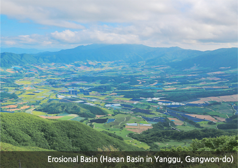
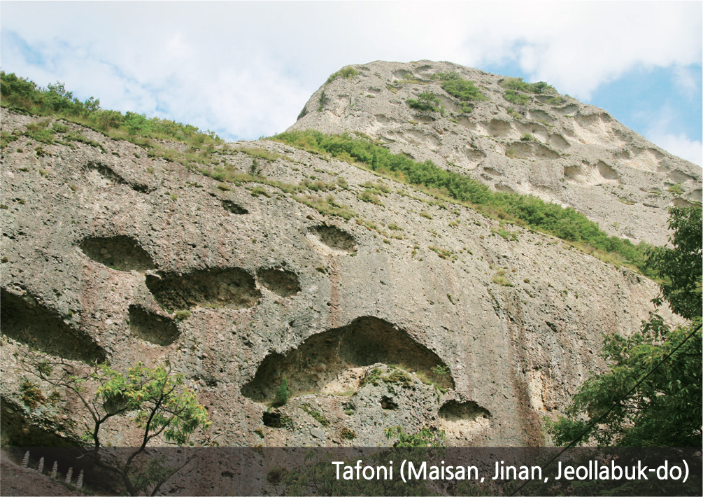
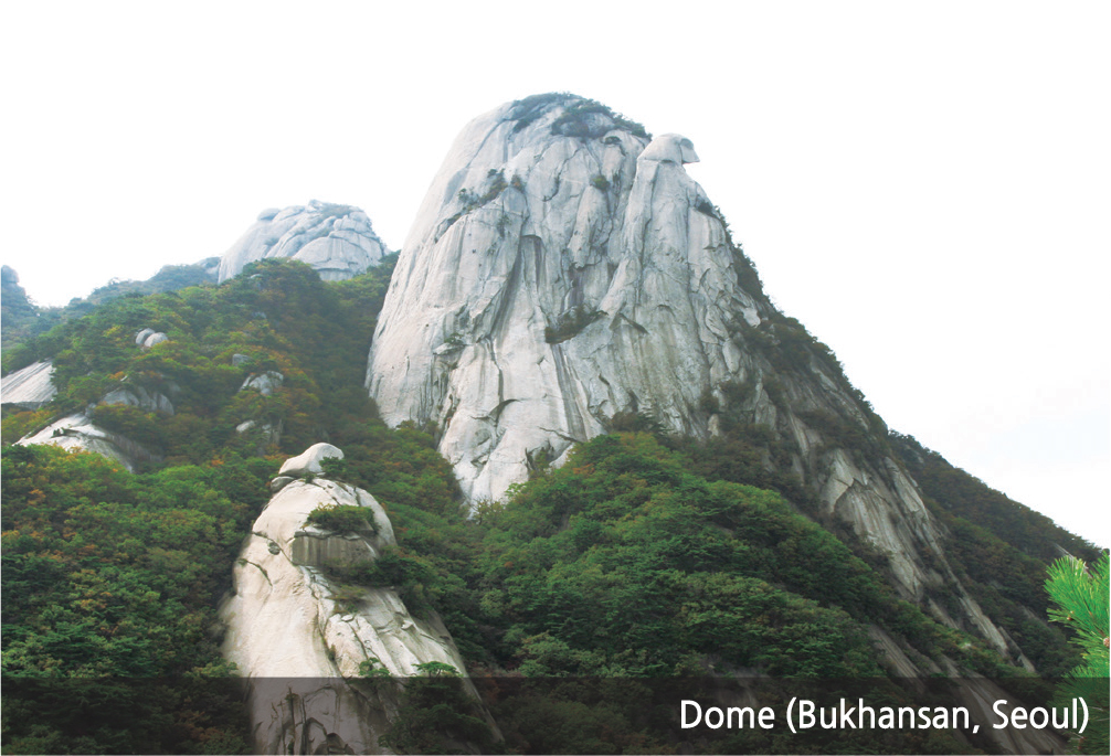
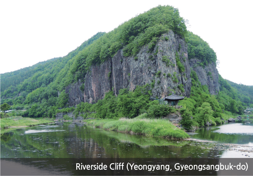
Although approximately 70% of Korea's territory consists of mountainous areas, there are not many mountains with high elevations. The highest peak in South Korea (excluding Hallasan in Jejudo) is Jirisan, located about 50 km north of the south-central coastline. It stands at less than 2,000 m. The higher mountains are distributed toward the eastern side, a phenomenon that was caused by the uneven warping of the Korean Peninsula. Bedrock that is resistant to weathering and erosion constitutes the high rugged mountains, while less resistant rocks characterize the lowlands, basins, and valleys. South Korea displays a complex topographic regime due to various bedrock compositions formed over different geological periods. For example, metamorphic rocks originate from the Pre-Cambrian period (over 540 million years ago), granite and volcanic rocks were formed during the Mesozoic period (between 66 and 250 million years ago), and sediments remain from the Tertiary and Quaternary periods (less than 3 million years ago). Typical eroded and weathered landforms include erosional basins, sinuous or meandering rivers, rock cliffs, rock domes, tors (large rock outcrops), tafoni (singular: tafone; small coastal caves in sandstone or granite formations), and caves. Depositional landforms include block streams, talus deposits, and upland wetlands. According to the Natural Ecosystem Survey, first grade landforms are generally located along the high mountains of Taebaeksanmaek and Sobaeksanmaek, and are also widely distributed in island areas.
Brief Interpretation of the Map
The map depicts the locations of Grade 1 mountain landforms of various kinds as illustrated by the photographs. Not surprisingly, their distribution pattern correlates with the mountain chains map on page 43. Different mountain landforms provide different utility values to human activities. While tafoni continue to erode, they, along with block fields, may cause hazards. On the other hand, erosional basins with alluvial depositions provide valuable farmlands. Locations of these landforms affect human activities.
Considering slope or gradient, hardness or softness of bedrock material, degree of ease for further erosion, effects on the neighboring environment, what are some of the criteria relating to landforms that you may need to consider in the construction of a highway?
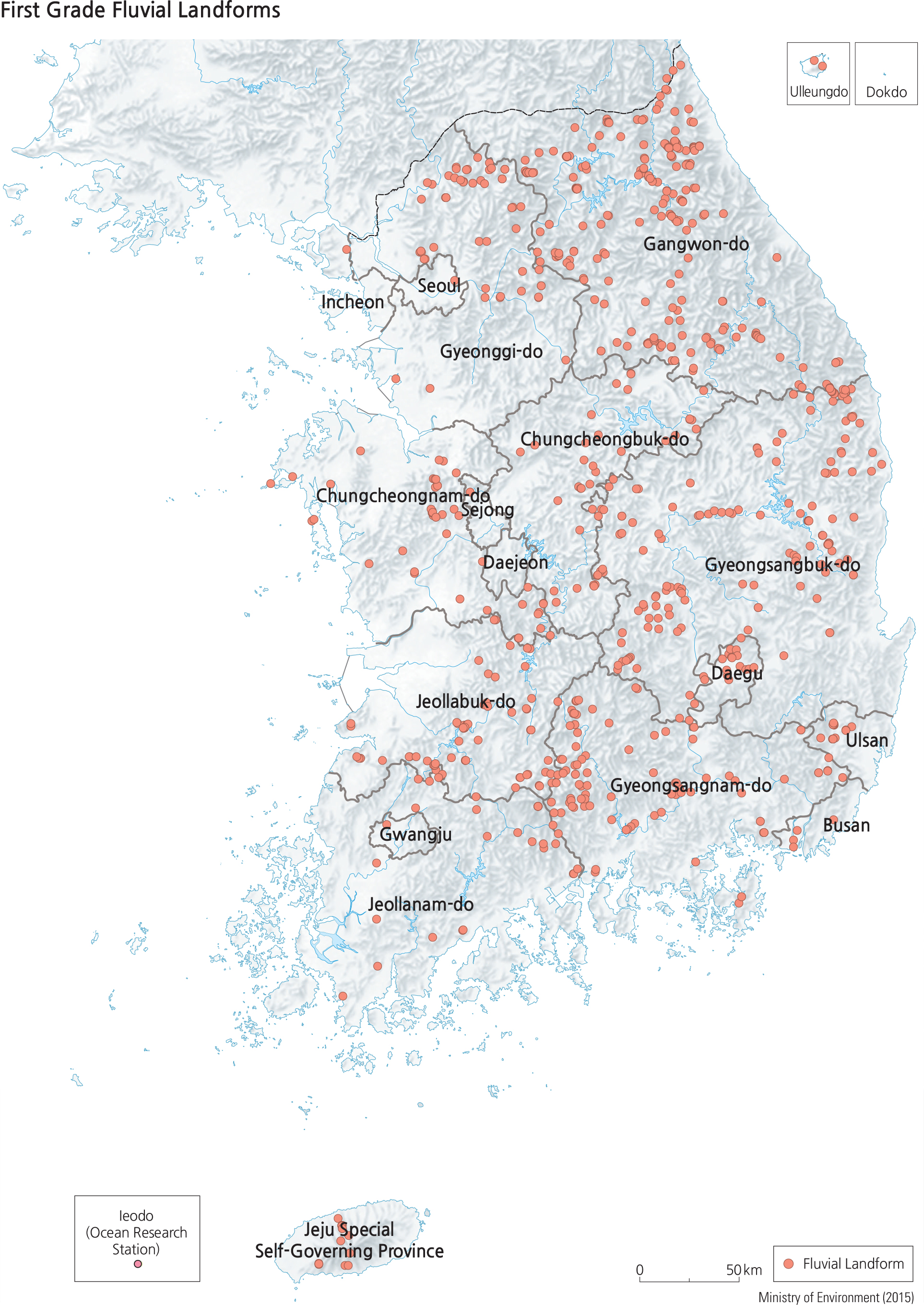
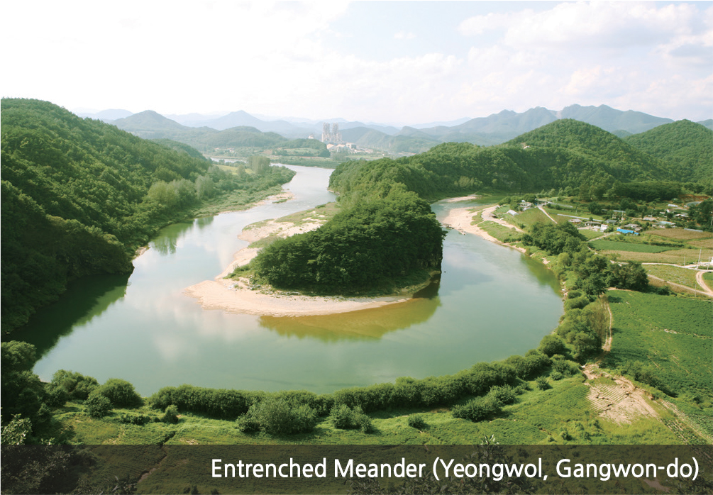
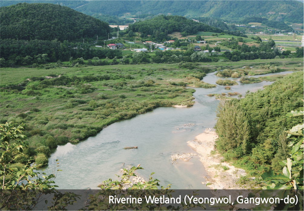
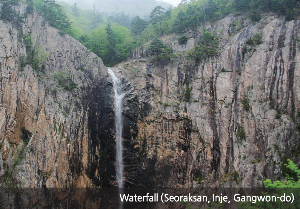
Rivers in Korea can be classified into straight, meandering, and braided. Straight rivers are bounded by exposed bedrock between narrow valleys and mounds; meandering rivers develop on wide floodplains; braided streams occur in almost flat, alluvial deposits where stream flows are slower and branch off into several unorganized parallel channels. Typical erosional landforms include waterfalls, potholes, riverine cliffs, and riverine caves, while typical depositional landforms are deltas, alluvial fans, riverbanks, point bars, and riverine wetlands. The floodplains formed by Hangang, Nakdonggang, and Geumgang (gang is the Korean word for river) constitute major agricultural plains in South Korea. The natural levees and backswamps of these floodplains developed from the last glacial period. Eroded valleys were filled with sediments due to rising sea levels. Deltas, which are an extension of floodplains, are shaped by sediment discharge from rivers, ocean tides, and waves. They are generally located where the mouth of a river on the floodplain meets the sea. The Nakdonggang Delta is a representative example. Alluvial fans are formed from small rivers and are mainly used for agriculture. Most eroded stream topography is observed in upstream areas of large rivers or around smaller rivers. In Korea, many of these regions have become tourist destinations as the exposure of bedrock creates a unique landscape. As a result, the most notable examples of river topography within the nation are generally located in upstream regions, rather than near the mouth of a river.
Brief Interpretation of the Map
The geographic pattern for first grade fluvial landforms is generally associated with inland reaches of the upper and middle courses of rivers in relatively higher grounds. By the time they reach the lower course, their environmental quality changes. Since river patterns follow closely to watersheds as defined by ridgelines, this fluvial landform map corresponds to the northeast to southeast trend of the mountain landforms of the previous page. In Korea, there is great diversity of fluvial landforms, from meandering rivers to riverside cliffs to hanging waterfalls. They provide different economic value to humans; scenic fluvial landforms attract tourists while lowland meandering landforms provide water for agriculture. Wetlands serve dual purposes: to provide sanctuary to biotic species and maintain a rejuvenated environment.
Given that water sustains life, including human lives that requires potable (suitable for drinking) water and clean hydroelectricity, what might be the best strategy in locating and building dams that sustain human life but at the same time, create adverse environmental conditions? Discuss some of these adverse environmental conditions. There are many dams in South Korea; most are purposely built away from the north and some are built close to industrial centers and urban centers: discuss the pros and cons of their locations (refer to The Major Land Development Projects Map on Page 69).
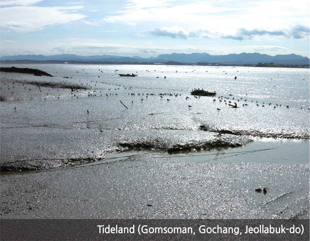
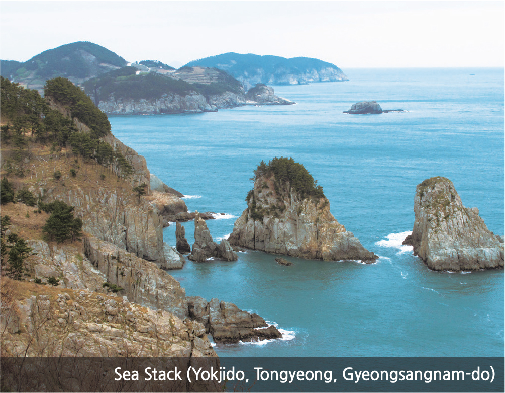
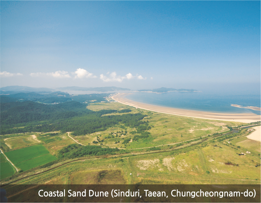
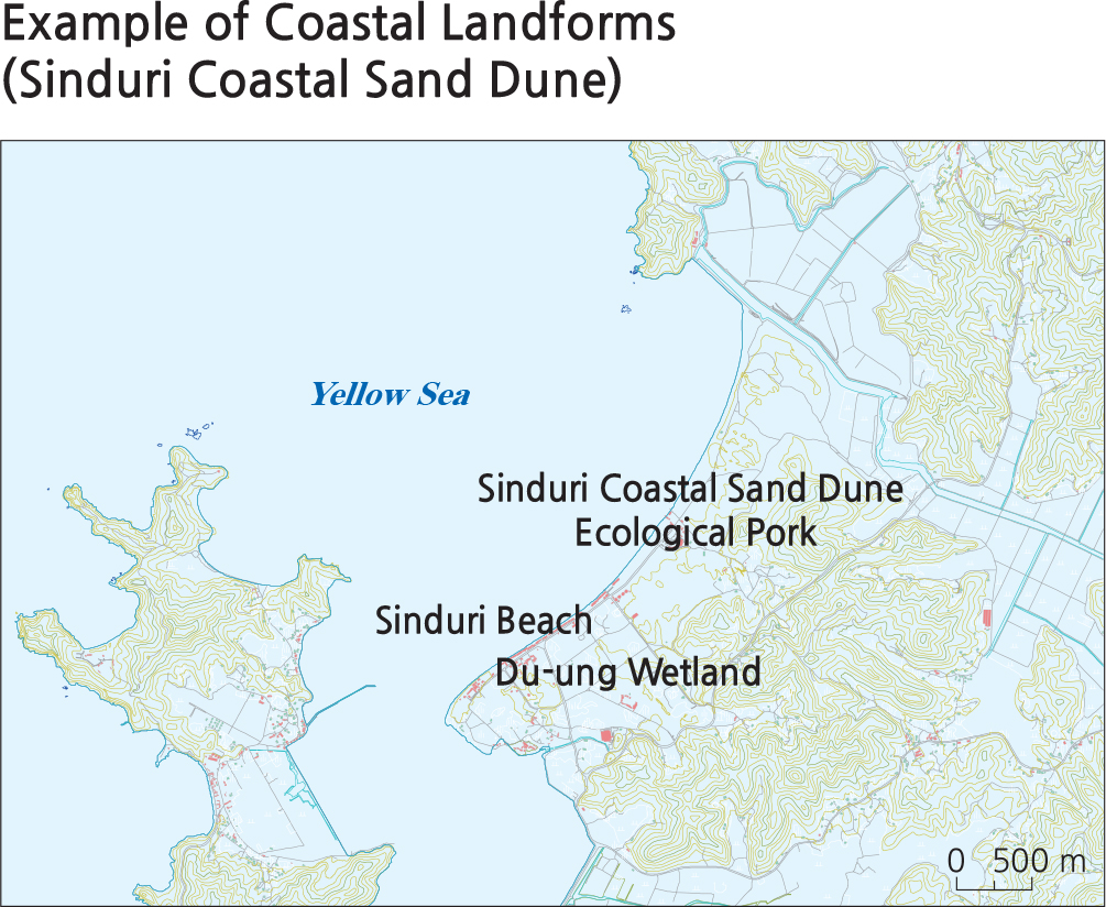
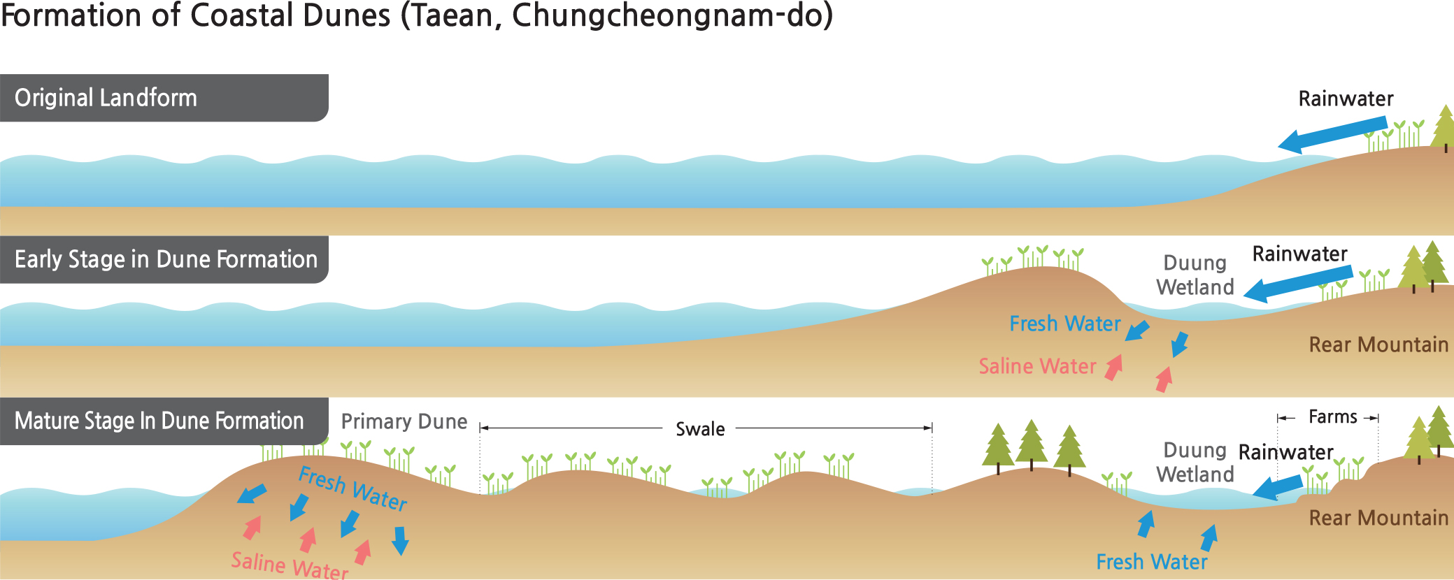
First grade coastal landforms are evenly distributed along the coastline, mainly around relatively less-developed islands. Korean coastal landforms can be classified as rocky, sandy, or muddy. Sandy coasts are observed in bays where active sedimentation by waves occurs. Coastal depositional landforms include beaches, sand dunes, sand spits, sand bars, lagoons, and tombolo (a sandbar that joins two islands or from one island to the mainland). Sandy coasts prevail in the eastern and western coastal areas, especially along regions exposed to the open sea such as the Taean Peninsula. Rocky coasts are indicative of erosional topography and develop along the headlands of mountainous and mound regions near the sea or where wave activity is strong. They are often found near major mountain ranges along the eastern and southern coasts. Sea cliffs, wave-cut platforms, and coastal terraces are also visible along the eastern coast of Korea. Muddy coasts are found along the western and southern coasts where flood and ebb tides are farther apart, wave activity is weak, and silt-sized particles are deposited. The largest tidal flats occur in Gyeonggiman (Gyeonggi Bay), where tidal range is as large as 8 –10 m. Intermingled with first grade coastal landforms are reclaimed lands, which normally have straight coastlines and dykes. Although reclaimed lands cannot be considered natural or classified as first grade, they do affect the surrounding water quality, wave actions, and deposition patterns around their environments.
Brief Interpretation of the Map
From this map, it is obvious that all first grade coastal landforms are along the coast and have great physical interaction with ocean waters through their waves, tides, and suspended sediments. Although the first grade level classification is artificially given to them, they do require constant protection from humans and the government because of their tremendous economic value. Harbors are built for protection of vessels during rough weather and frequent typhoons. Seaside recreation facilities provide leisure activities to citizens. The fishing industry depends on access to the seas and an appropriate environment for the maintenance of vessels. Scenic outlooks attract tourists and promote tourism. Since the 2010s, many wind farms have been built on coastal landforms and even into shallow bays to harness renewable energy. There are even hydrothermal power plants that are built in shallow offshore locations. Aquaculture (farming for seafood) has become an important industry in Korea, providing such food as oysters, seed weed (a constant in the Korean diet) and various species of fish. The many benefits of coastal landforms interact in a very complex manner with human activities.
Can you think of ways to protect coastal landforms without curbing human use? Discuss some of the strategies for maintaining important human activities while preserving first grade coastal landforms.