When we refer to the environment of a place, there is generally a complex relationship between the natural/physical processes and human uses of natural resources from the land, water, and atmosphere. In the process of extracting natural resources from the natural world, we also alter its state in ways that may be either positive or negative. This is why we need to study the environment. An adverse environment will tend to harm the human race while sustaining a viable environment will provide healthy living conditions.
This chapter is intended to bring awareness to environmental conditions of South Korea and to reveal some of the thinking and processes it has implemented to help mitigate issues of environmental degradation due to pressures from increased population, industrial growth, demands for agricultural products, and the need for energy consumption. We begin with the physical environment of Dokdo, a place that seems to have relatively less environmental pressure than other places in Korea.
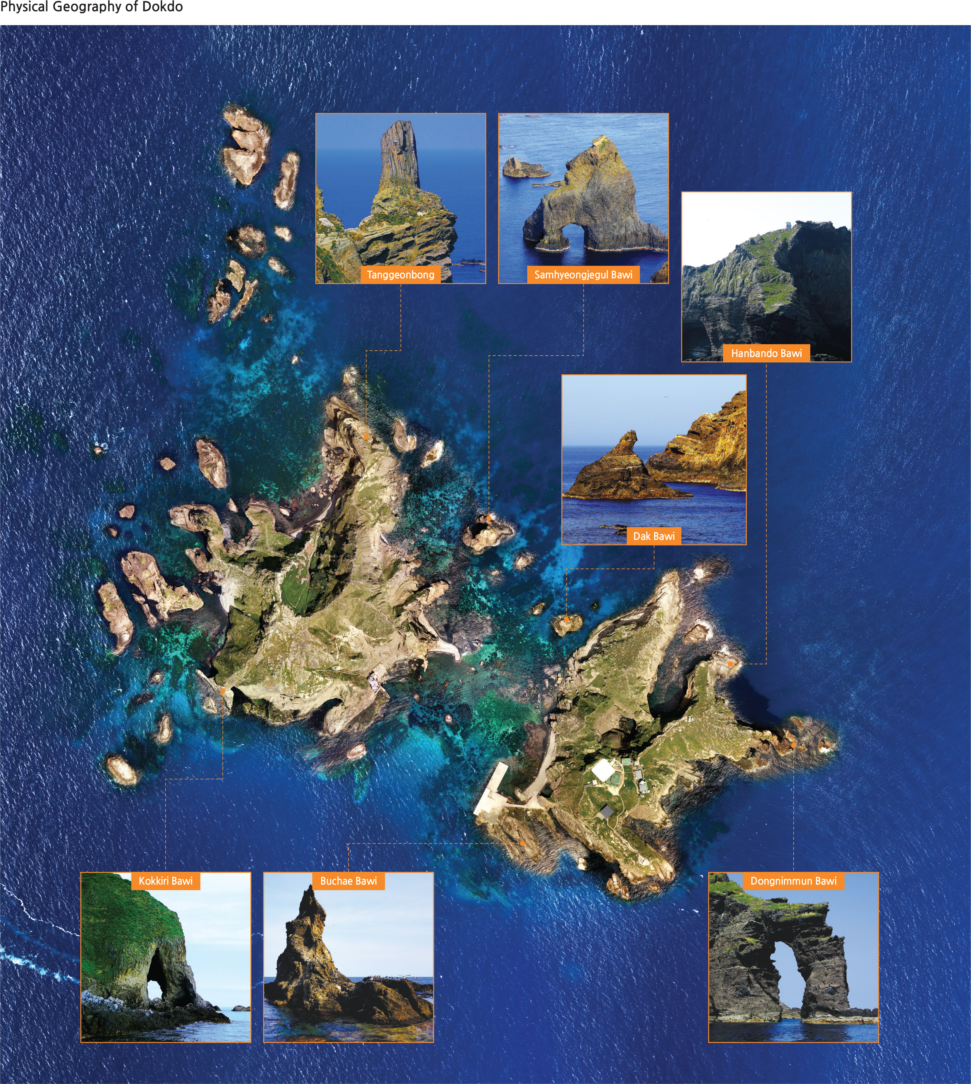
Physical Environment of Dokdo
Dokdo is a volcanic island that was formed by lava which erupted about 2,000 meters underwater in the East Sea. It was formed between 4.6 million and about 2.5 million years ago. Ulleungdo was formed later, sometime between 2.5 million and 10,000 years ago. The geology of Dokdo is alkaline volcanic rocks: the main rock above sea level is made up of andesite, and most of the undersea rock is believed to consist of basalt. The island is actually a part of a gigantic, round volcano (the Dokdo Seamount), with a base reaching more than 2,000 meters deep. As the topographical map shows, the Simheungtaek and Isabu Tablemounts are in the eastern part of the Dokdo Seamount, while the Anyongbok Seamount is located between Ulleungdo and Dokdo.
The East Sea belongs to the group of marginal seas in the North Pacific running from the Okhotsk Sea to the South China Sea. Waters around Dokdo, located at the center of the East Sea, are where the North Korea Cold Water (NKCW) and the East Korea Warm Current (EKWC) meet. The East Sea near Dokdo is characterized by a very complex submarine topography. It consists of three topographic highlands more than 2,200 meters deep in the west; they get shallower towards the east. The strait between Dongdo and Seodo is 330 meters long, varying in width from 110 meters to 160 meters, and it is 5-10 meters deep. The depth of water surrounding Dongdo reaches hundreds of meters at certain places, depending on its distance from the coast; however, the waters near Seodo are shallower than those around Dongdo.
The warm and cold currents circulate and meet near Dokdo. Where warm and cold ocean currents meet, an area is created that is rich in plankton, an important food source for fish. Environmental conditions are also very good in the coastal waters of Dokdo in large part due to their long distance from land and their relative isolation. The sea around Dokdo is relatively undisturbed by human activities, and so it is home to a diversity of marine life.
The waters around Dokdo are abundant with squid and many different types of fish. Squid accounts for more than 60% of the total catch in areas near Dokdo. The drift catch of rays and flatfish, as well as the trap fishery of red snow crab and shrimp, account for tens of millions USD profit every year. The fishing grounds around Dokdo possess such significant economic value that they represent an important outpost for the Korean fishing industry in the East Sea. As of 2014, 495 animal species and 223 types of algae have been recorded as marine life resources along the coast of Dokdo.
A crossroads for bird migration routes, Dokdo serves as a midpoint rest stop for migratory birds. As such, it also serves as an important natural laboratory for scientific research on the origins, migration patterns, and destinations of these birds. The Dokdo Ecosystem Monitoring and Plant Gene Analysis in 2013 confirmed a total of 76 species of birds live or frequent Dokdo, including 4 endangered species. It is also home to the shearwaters, stormy petrels, and black-tailed gulls that only reproduce in Northeast Asia. In order to protect the breeding habitat, the Ulleung-gun Ulleung-eup Dodong-ri, Mountain 43, lot 34, with an area of 178,781 square meters, has been designated as the National Cultural Heritage Natural Monument No. 336 (Dokdo Seaweed Habitat), according to the Cultural Properties Protection Law of November 16, 1982. In addition, at least 60 species of plants and 129 species of insects inhabit the island. Since 2005 when monitoring of the Dokdo ecosystem was conducted, new species of life have been found every year. Eleven previously unrecorded species, including spindle trees (Euonymus hamiltonianus) and red knots (Calidris canutus), were recorded in 2013. The fact that the island is a very rich repository of natural resources motivated the government to designate the island as the Dokdo Natural Protection Zone on December 10, 1999 and increased the designated area to 187,554 square meters.