The year 1953 was the aftermath of decades of Japanese occupation (1910–1945) and fighting the Korean War (1950-1953). South Korea was a war-torn nation with poverty, land devastation, and destroyed infrastructure. With the lack of natural resources and little national capital, rebuilding a nation was a daunting task. Until the early 1960s, Korea was forced to focus on recovering from the devastation of war by utilizing international aid to restore public facilities and rebuild the national economy.
The governmental master plan for land development was put into action in the early 1960s. Many parts of the plan were based on principles and theories of human geography and the practice of cartographic analysis. At that time, the government based the plan on the growth pole theory, concentrating in a small number of places with the highest promise of success. This approach was aimed at maximizing the development effect in the shortest of time. However, the growth pole theory resulted in the imbalanced flow of people and capital to only a few development centers. Under the Special Area Development Project, Seoul, Incheon, and Ulsan were selected as growth poles or Special Areas to be developed first on
the premise that the effects of such development would gradually enfold the surrounding areas. The Industrial Park Development Project began in Ulsan and Seoul in the early 1960s. Also, during the 1960s and 1970s, the Industrial City Construction Project was launched with targeted sites near such industrial parks. This led to the emergence of major chemical industries concentrated in Ulsan, Yeocheon, Pohang, and Gumi with a concordant rise in population in each of these cities.
Urban migration, families moving to live in the city, increase in national income, and more widespread expectations for a higher quality of life led to soaring demands for housing in the 1980s and 1990s. The housing supply rose to keep pace with the demand. In 1950, the number of housing units was 3,280,000; by 2011 it had increased five-and-a-half times to 18,130,000. The increase was a result of many government housing-related development policies.
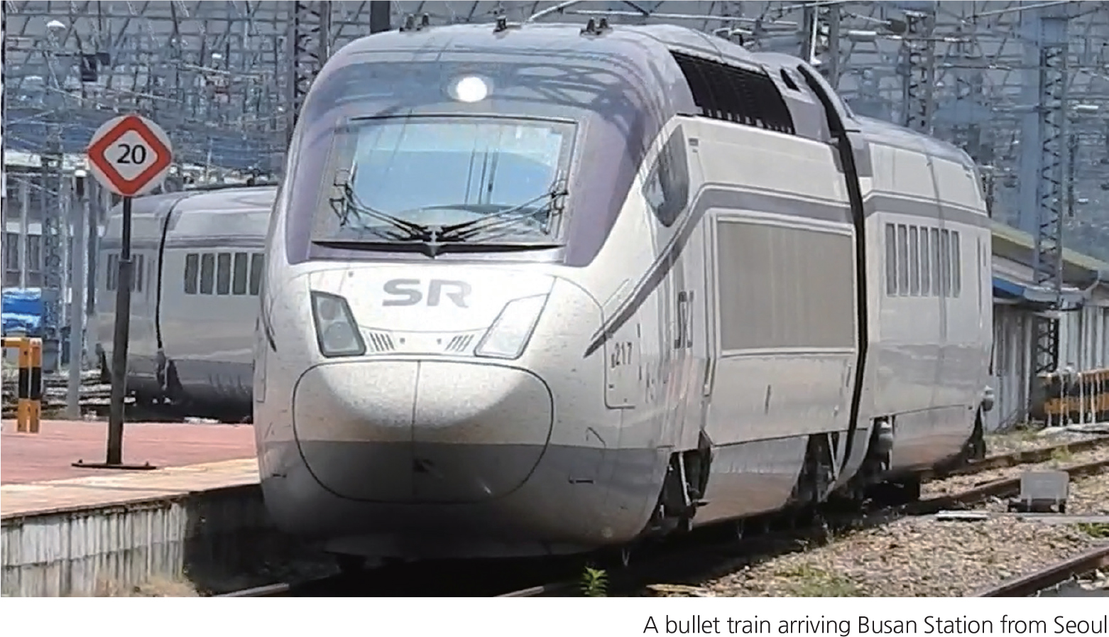
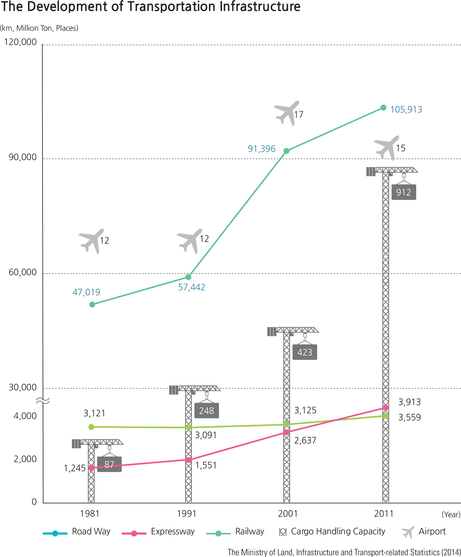
As economic development gained momentum in the 1960s, the transportation infrastructure was rapidly built to support the transformation of the nation. The most notable project was the 428 kilometer (260 miles) Gyeongbu Expressway which connects Seoul with Busan. Construction began in 1968, and the expressway opened for service in 1970. It serves as the main corridor through the country. Since the late 1980s more and more roads have been built and improved as the number of cars has soared and the volume of road traffic has increased. The modernization of rail traffic has been ongoing. In 2004, the Seoul-Busan High Speed Railway began operation with a bullet train capable of traveling at 180 miles per hour. The majority of marine transportation is used for overseas transportation rather than domestic purposes. Major port facilities of Korea are primarily located along the southeastern coast, which facilitates the import and export of materials and products needed for chemical industrial plants located in the same region. In 2006, the Busan New Port began operation and has become the center for international marine transportation.
Air traffic development began with the construction of airfields built for military purposes during Japanese colonization. Gimpo Airport opened in 1958 and Jeju Airport began operations in 1968. Air transportation in Korea has opened a new chapter with the opening of the ultra-modern Incheon International Airport on Yeongjong Island in 2001.
Other major development projects from the 1970s to the present include a number of natural resource and energy related projects such as reforestation, land reclamation, multipurpose dam construction, and nuclear power plant construction.
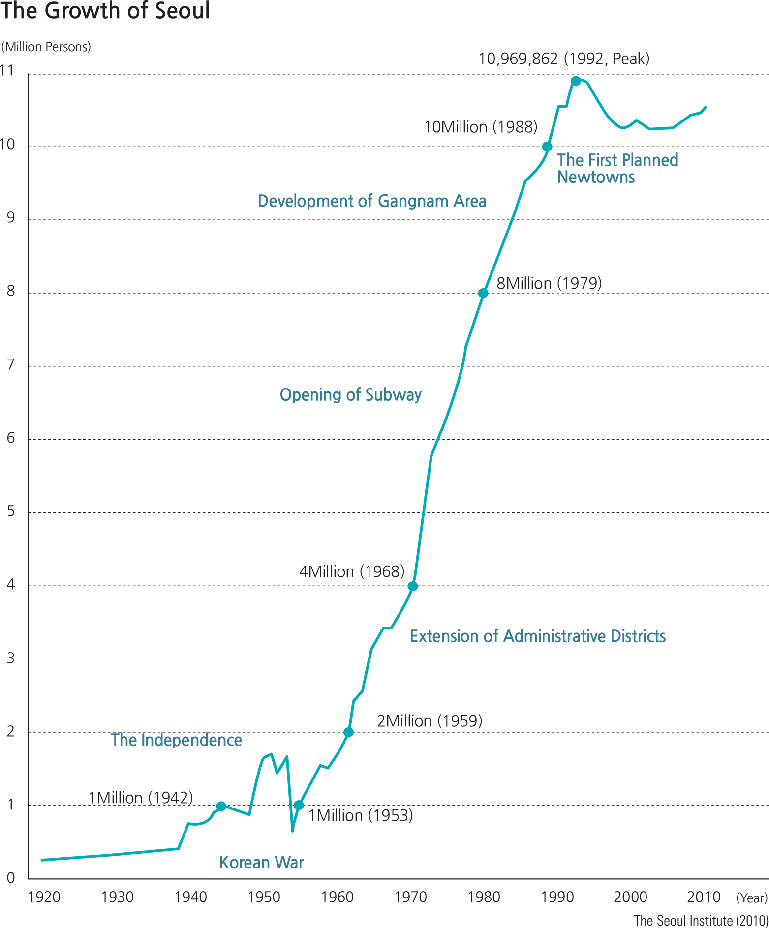
Urbanization has had major impacts on Korean demographics, the physical landscape, social behavioral institutions, as well as the economy. Both the number and sizes of cities increased, as the population of rural areas declined, which also led to a decrease in the percentage of the population that was engaged in agriculture, fishing and fishing-related activities.
The emergence of metropolitan centers is a major feature of development in Korea and resulted primarily from the rural-to-urban migrations, especially in the capital area. More jobs were created prompting further mass migrations from rural to urban areas. The urbanization rate, which indicates the ratio of urban population as a percentage of the total population, increased rapidly in Korea until the 1980s, but the pace has slowed since then. Rural areas suffered from the lack of a labor force, a decrease in the efficiency of land utilization, and the rapid aging of the population. In many instances, these factors ultimately contributed to the failure to meet the minimum requirements for sustaining a rural community. At the same time urban areas were confronted with the need to mitigate the challenges of overcrowding. Additionally, the heavy concentration of industrial activity within the metropolitan areas resulted in serious social and environmental issues such as housing shortages, traffic congestion, poor air quality, and overall environmental degradation.
Since the 1960s, by building industrial complexes and new cities, the South Korean government has fostered economic growth through export. Beginning with the Ulsan Industrial Complex, which was completed in 1962, and the Korea Export Industrial Complex (Guro Industrial Complex) in 1964, many industrial complexes and adjacent cities emerged in and around Yeocheon, Pohang, Gumi, Incheon, Changwon, Banwol (Ansan), and elsewhere from the late 1960s through the 1970s.
The importance of water as a resource was recognized in the 1960s; thus, the multipurpose Seomjingang Dam was built in 1965 across the Seomjin River. More multi-purpose dams were built through 1980s; the Soyanggang Dam, Daecheong Dam, and Chungju Dam are notable examples. These all possess hydroelectric power generation capabilities. In 1978, the first nuclear power plant, the Gori Nuclear Power Plant No. 1 was built and began operating near Busan. Subsequently, more nuclear power plants were built in Wolseong, Uljin, and Yeonggwang.
For the last 60 years, there have been many changes in the Korean landscape, most of which have stemmed from government-led land development projects, urbanization, industrialization, and the building of important infrastructure that stimulate growth. The progress since the Korean War is nothing short of an impressive and rapid transformation of the nation.
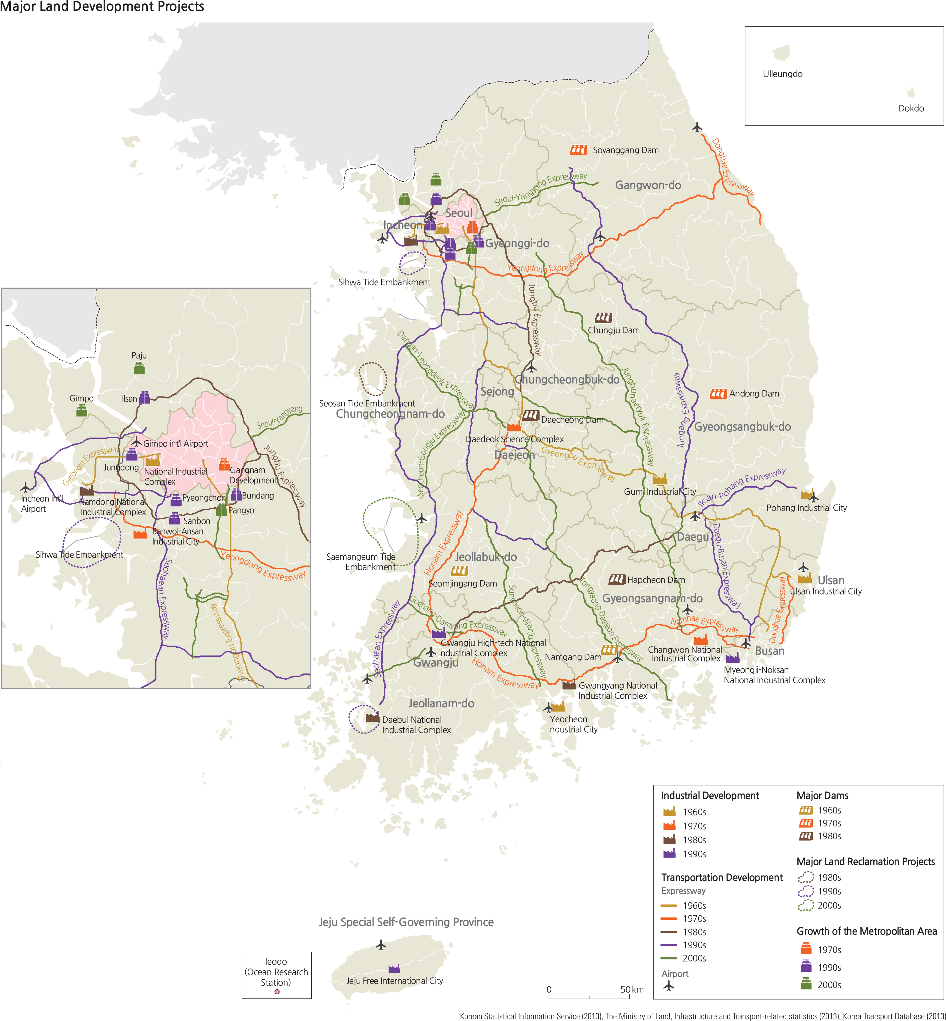
Brief Interpretation of the Map
The map briefly highlights the locations of major developments in industrial complexes, transportation networks, major dams, land reclamation, and growth of metropolitan areas. Two geographic patterns stand out: the reclamation areas are all on the west coast and the newest dams and industrial developments are mostly in the south. The more rugged east coast and the short rivers that flow to the east do not generate any delta areas that are suitable for reclamation. The locations of newer dams and industrial developments in the south were planned to avoid potential conflict from the North; in addition, these industrial developments pertain to the shipping and export industries that need port facilities along the coast. Transportation networks are well developed except for the northern and eastern parts of the country.
Examine the lack of any development in the north and east and compare this area with the satellite image on page 23. Suggest reasons why these areas are not developed. What kind of geographic factors make them not suitable for industrial development? Think of any kind of economic developments that are suitable. (Hint: how can the beauty of the land create financial and environmental benefits?)