The spatial distribution of climate in Korea is determined by key climate factors such as latitude, elevation, geographical location, land/sea heating properties, ocean current, the East Asian Monsoon system, and air mass. During the summer, it is hot and humid in response to the East Asian Monsoon, but during the winter, it is cold and dry.
The Asian Monsoon system over East Asia (including Korea, China, and Japan) is formed by the land-sea distribution and the associated difference in heating properties. While cold, dry wind from the northwest blows into the Korean Peninsula in the winter as a result of the continental effect, hot and humid southeasterly wind blows into Korea during the summer from the North Pacific. The climate of Korea is also under the influence of various air masses such as the Siberian, the North Pacific, the Okhotsk Sea, and equatorial air masses.
The difference in temperature between the northern area and the southern area is clear. This is because of the amount of solar energy received and the difference in length of daylight that varies with latitude. The difference in annual mean air temperature between Seogwipo (16.6ºC), located near the southernmost tip of South Korea (33° 14' N), and Cheorwon (10.2ºC), located at the northernmost tip (38° 08' N) of South Korea, demonstrates a wide variation in air temperature because of latitude.
The climate features also vary with elevation. The annual mean air temperature at Daegwallyeong (773 m), the highest observation station in South Korea, is 6.6°C, which is 3.7°C lower than that at Hongcheon (10.3°C) at an elevation of 141 m even at a similar latitude. The difference in the mean air temperature is also found in the southern area between Imsil (248 m) and Jeongeup (45 m), with 11.2°C and 13.1°C, respectively.
Geographic location can also affect climate. As an example, we examine two locations: Yeondong (east of the Taebaek Mountain Range) and Yeongseo (west of the Taebaek Mountain Range). During winter when a cold northwesterly wind dominates over the Korean Peninsula, the temperature at Chuncheon, a city in the Yeongseo area, is low because it is in the windward side of the winter wind direction. Sokcho, a city in the Yeongdong area, is warmer because it is in the leeward side. However, the situation reverses if the winter wind comes from the northeast; Sokcho is now in the windward side and will have a colder temperature than Chuncheon, which is now in the leeward side. Because the northeasterly wind comes in over the East Sea after picking up moisture from the warm currents, heavy snow occasionally falls in the Yeongdong area as the wind ascends the cold Taebaek Mountain top.
Korea is largely characterized by a continental climate due to the effects of the Eurasian continent. However, the climate of the coastal areas, which is mostly affected by the ocean, differs from that of the inland areas. The annual mean temperature range for Daejeon is only 0.3°C greater than that of Boryeong, which is adjacent to the coast. The average temperature during the summer (months of June, July, and August) in Daejeon is approximately 1.3ºC higher than that in Boryeong.
Ocean currents can also affect the climate of Korea. East Korean Warm Current and North Korean Cold Current in the East Sea as well as the Yellow Sea Warm Current all play a role in affecting Korea’ climate (see maps on page 57).
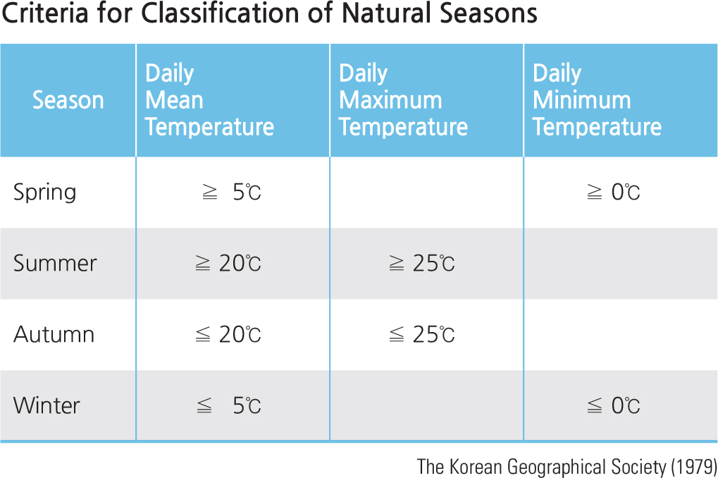
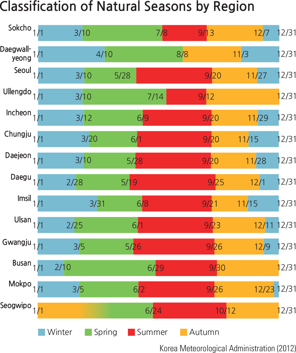
The classification of natural seasons based on the criteria of daily mean air temperature, daily maximum air temperature, and daily minimum air temperature results in regional differences in beginning dates of the year and number of days for each season. Spring comes the earliest to the Korean mainland in Busan (February 10) while it comes latest in Daegwallyeong (April 10). Except for Daegwallyeong (August 8) and Sokcho (July 8), summer mostly begins between late May and early June and lasts about 70 –120 days. Autumn starts around the middle of September, with shorter duration (60 –80 days) than spring and summer. Winter generally commences around late November, lasting about 100 –130 days.
Brief Interpretation of the Maps
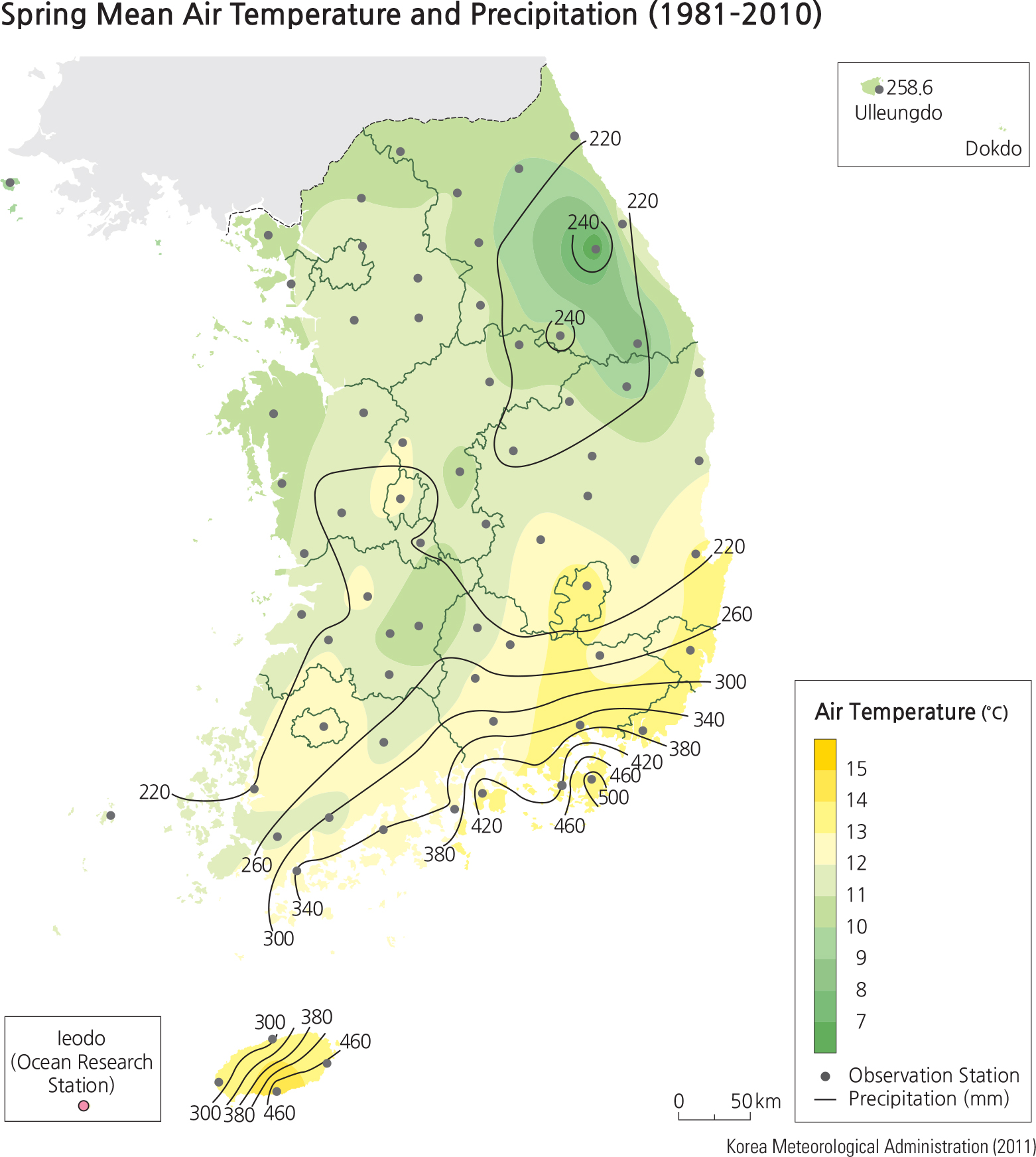
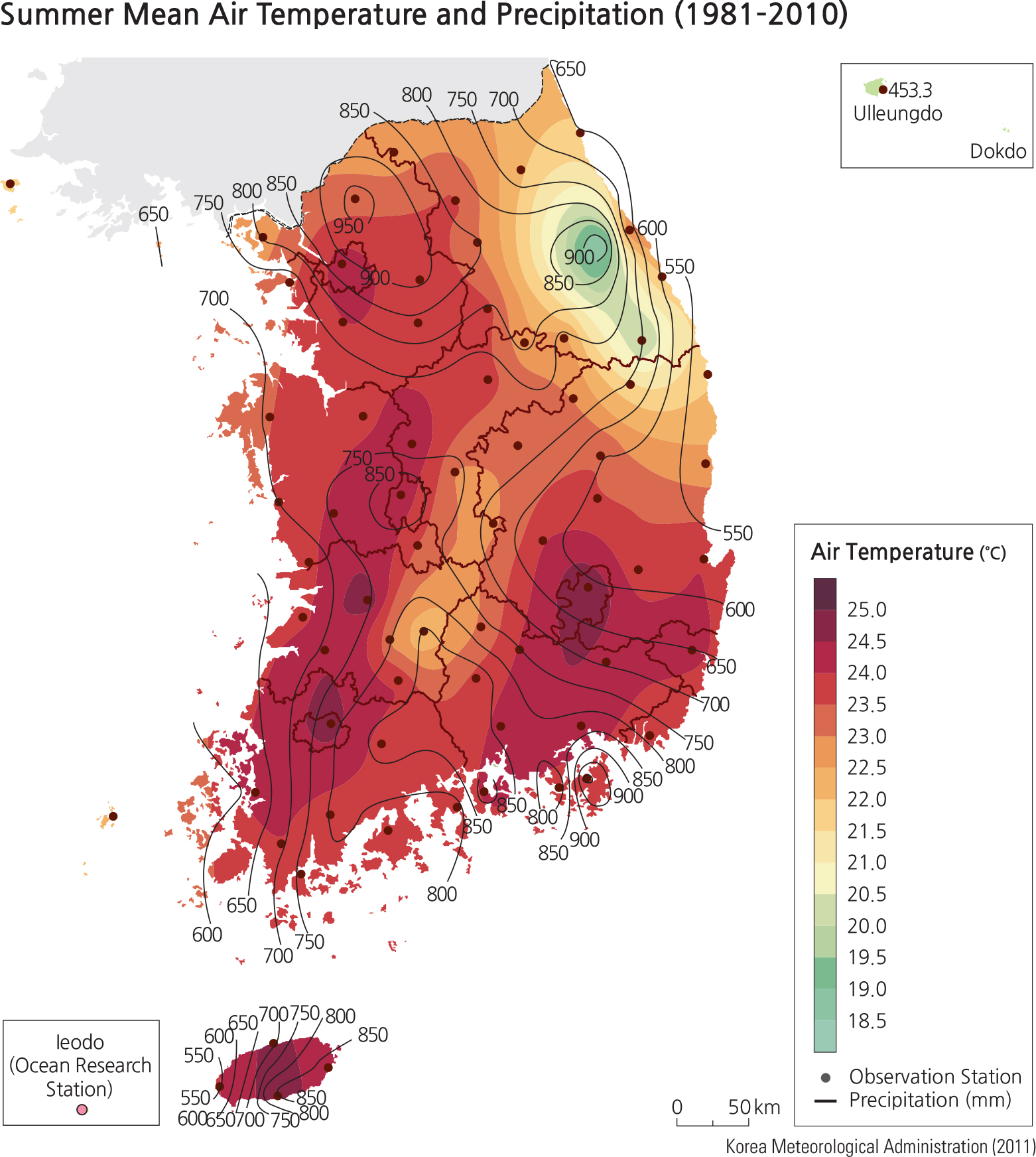
The patterns of precipitation and temperature in the different seasons in South Korea provide an additional element to the perception of Korea' landscape that helps to develop a more detailed mental image of the geography of Korea's different districts and provinces. Without the seasonal elements of climate to add visual depth to the different areas, South Korea seems to appear quite similar throughout based on location relative to the sea and elevation.
The island of Jeju, about 100 km south of the south coast of Korea, has quite a distinctive pattern of temperature and rainfall. As expected except in the summer, it reflects the influence of the ocean. In the summer it has an average temperature of about 25ºC (75ºF) and receives an average of approximately 700 mm (25 in) of rain from June to September. In the spring, Jeju's temperatures of 13ºC are similar to those in southeast Korea, also reflecting the influence of the sea. In the autumn and winter Jeju is warmer than the mainland with somewhat more precipitation.
Year round there is one area that shows distinctive weather patterns. About 25 km west of Sokcho, the mountainous region that reaches to 1,300 m displays colder temperatures and is associated with greater precipitation than its lower areas nearby.
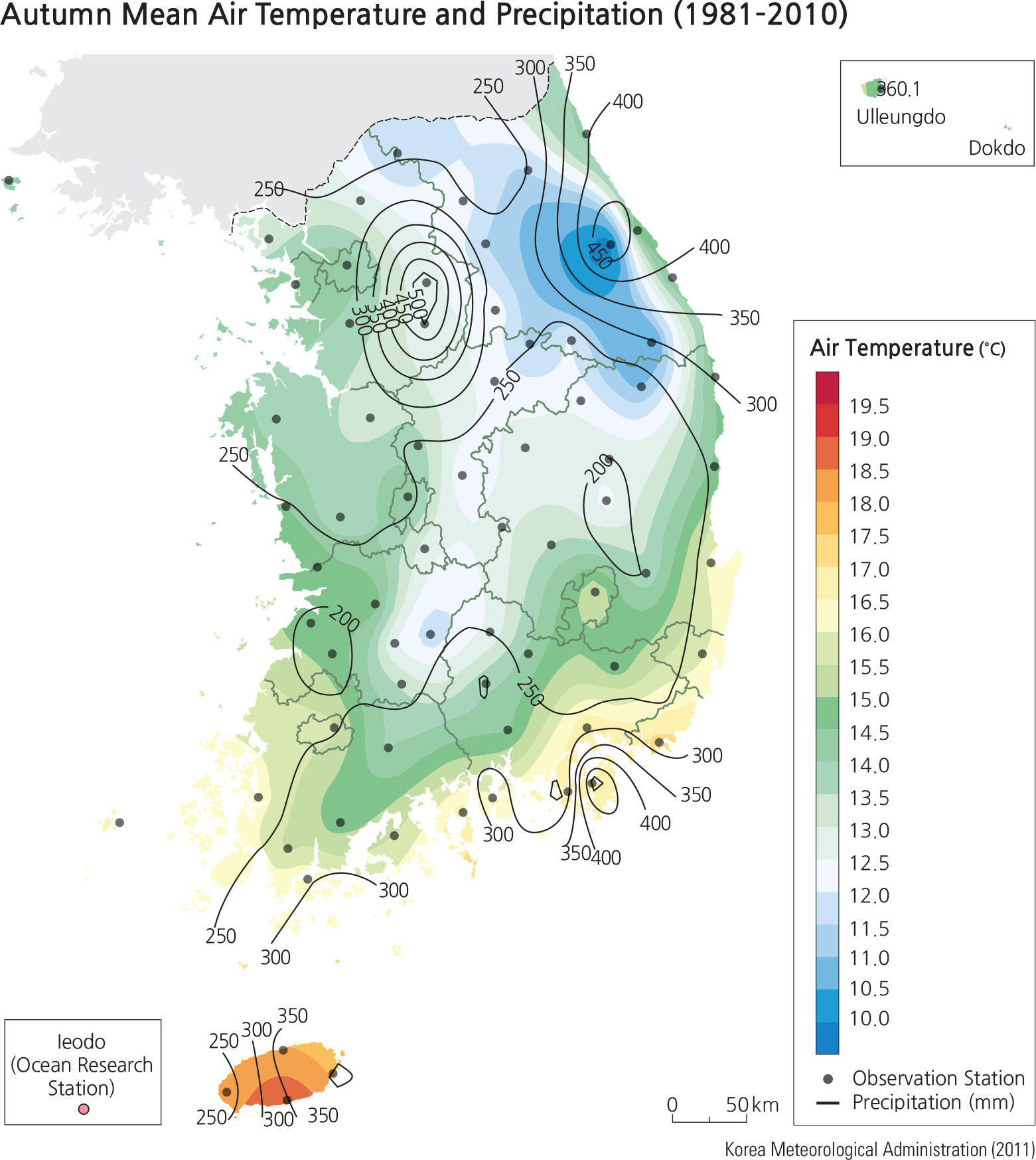
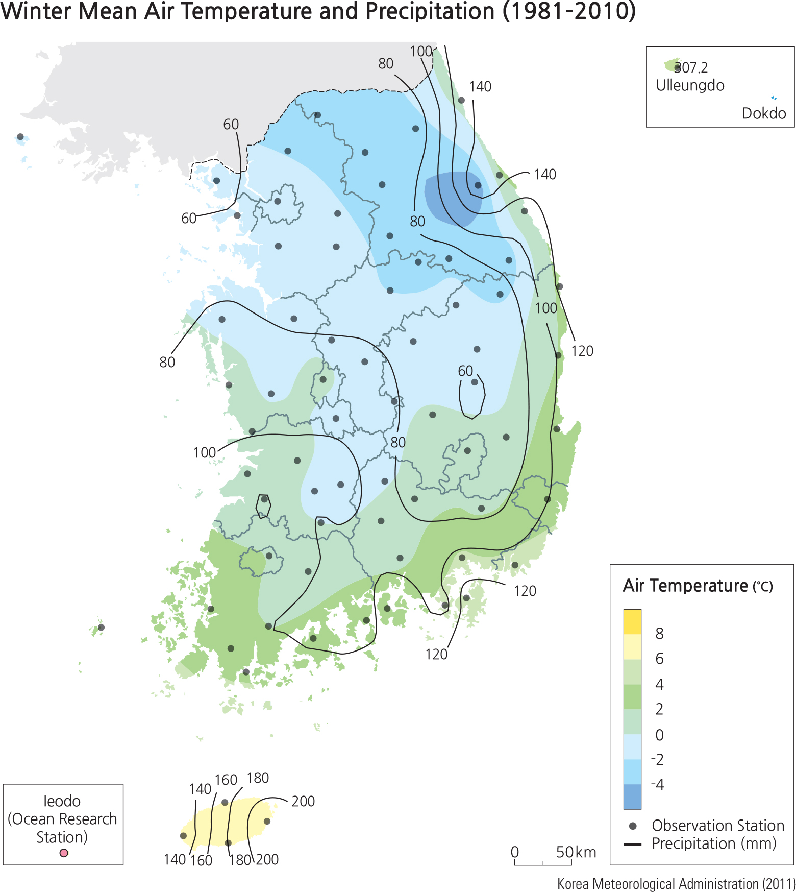
In general, on the South Korea mainland, there are two main types of weather: the coastal region, which is wide in the west, narrow in the east, and about 100 km wide in the south, and the higher, more dissected areas in the center. The central part of the Peninsula, lower on the south and higher and closer to the coast on the northeast, is cooler and associated with more precipitation in most seasons in the form of rainfall. In the spring, the coastal areas are warmed more by the coastal sea, ranging from 15ºC (59ºF) in the south to 7ºC (45ºF) in the north, with precipitation of 450 mm (17 in) on the south coast to 240 (9 in) on the north. In the summer the temperature is more similar throughout, with various high points ranging from 25ºC (77ºF) to 22ºC (71ºF) in the higher central zone, a pattern more like Jeju than any other season.
The rainy season is the summer, ranging from 900 mm (35 in) to 600 mm (23 in), with less rain in the northeast. In the autumn and winter, as to be expected, the temperatures are cooler across the Peninsula. In the autumn the higher mountain areas fall to 10ºC (50ºF) and to around freezing in the winter in the higher areas, with the south coast warmer to around 15ºC (59ºF). Precipitation decreases in both autumn and winter to 150 to 200 mm (6–7 in) at the higher elevations, to 50 to 60 mm (2–.5 in) nearer the coast. The winter shows temperatures from 0ºC (32ºF) to -4ºC (28ºF) and much less precipitation throughout.
Almost all of the temperatures and precipitation values on these maps are 30-year averages. There are local highs and lows that are much more variable from year to year and in different seasons. However, it is the stability of these values that provides a critical baseline for the evaluation and prediction of the effects of changes in the climate due to human and environmental conditions.
The area just to the east of Seoul shows a much higher average zone of rain in autumn, 200 mm (8 in) more, than the surrounding lowlands. What could account for this difference in that urban area? If one were studying the average rainfall for the period of 1890 to 1920, would a similar pattern exist? Do other urban areas in South Korea show a similar pattern? If Jeju showed that in a five-year period from 2020 to 2025, there were three abnormally warm winters with a 50% increase in rainfall, would this be clear evidence of global warming?
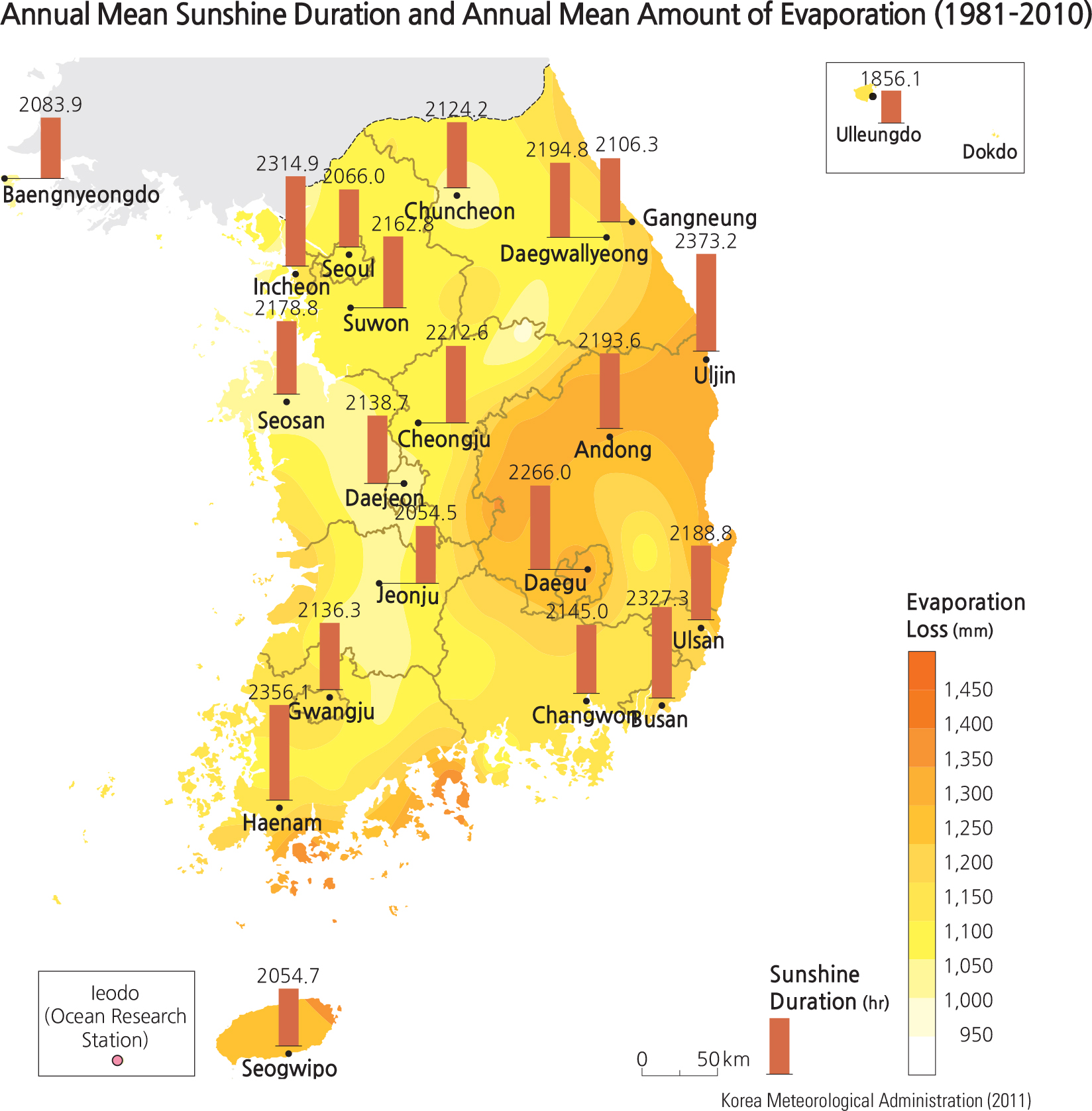
The annual mean sunshine duration is short in island areas such as Seogwipo City on Jeju Island (2,054.7 hrs), Ulleungdo (1,856.1 hrs), and Baengnyeongdo (2,083.9 hrs). On the other hand, the annual mean sunshine duration is long in the Yeongnam inland areas, the southeastern coastal areas, and the southernmost parts of the Taebaeksanmaek. Uljin on the east coast has the longest duration (2,373.2 hrs), followed by Haenam (2,356.1 hrs), Busan (2,372.3 hrs), Daegu (2,260.0 hrs), and Andong (2,193.6 hrs). In terms of amount of evaporation loss, Yeosu, south-central coast, has the highest (1377.6 mm) while Ganghwa, a district in Incheon, has the lowest (956.8 mm).
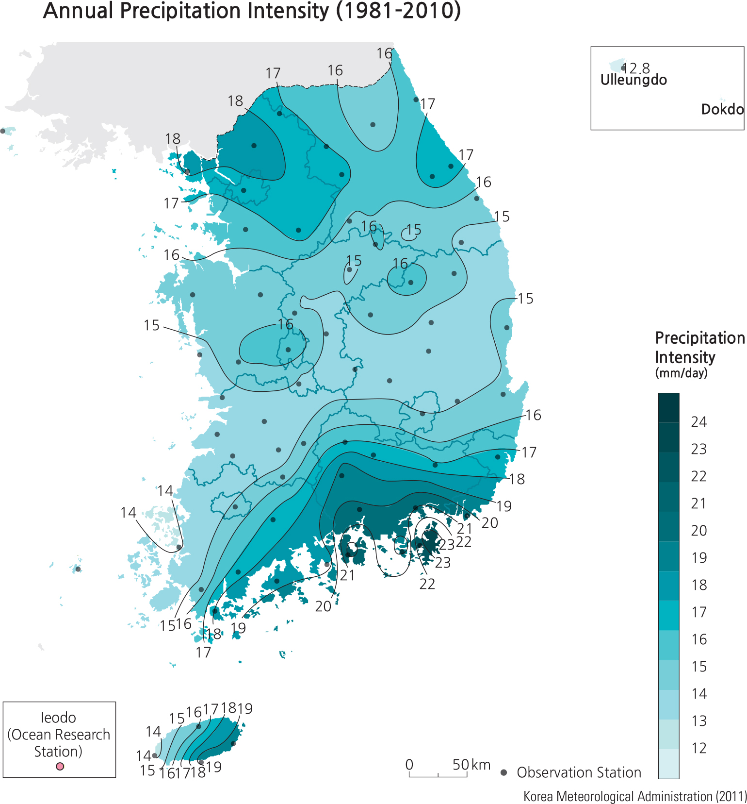
Annual precipitation intensity is a climate index, calculated by dividing annual precipitation by the annual mean number of precipitation days. The precipitation intensity appears relatively strong in the southern region, including Jejudo and the northern part of Gyeonggido. For instance, the southern coastal region has a precipitation intensity greater than 20 mm/day in general. The precipitation intensity appears relatively weak in the middle section of the country around the inland areas of Gyeongsangbuk-do, the western coastal areas of both Jeollanam-do and Jeollabuk-do, and Ulleungdo. Annual Precipitation Intensity increases slightly towards the northern third of the nation.
Daegwallyeong experiences the highest annual mean number of days with fog (132.3 days) due to high altitude. On average, the eastern coast has more foggy days than the western coast. Low numbers of foggy days are found in Changwon (4.8 days) and Daegu (6.8 days). The annual mean number of Asian dust days varies from 3.4 to 14 days. The number of Asian dust days decreases from the west coast to the east coast because the dust moves along with the westerlies. Baengnyeongdo, a western island, has the most number of days (14 days) while Ulleungdo, an eastern island, has the fewest (3.4 days).
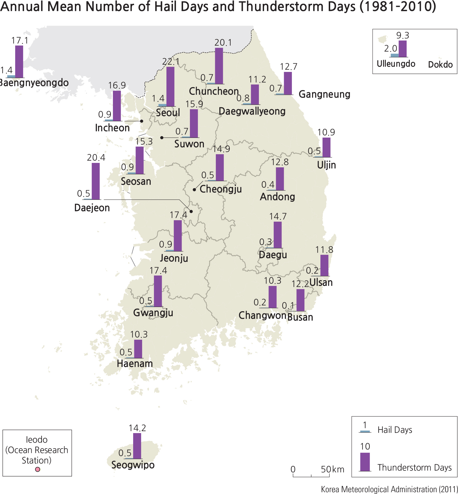
The greatest annual mean number of days with hail occurs in Ulleungdo (2 days). Baengnyeongdo and Seoul have the second greatest number of hail days (1.4 days). The maximum annual mean number of days with thunderstorms occurs in Seoul (22.1 days), followed by Daejeon (20.4 days) and Chuncheon (20.1 days). It decreases from the west coast to the east coast. Ulleungdo has the lowest number of thunderstorm days (9.3 days).
Brief Interpretation of the Maps
In the Core Map Skills section, one of the caveats about map accuracy is the adequacy of having enough data points to generate a map pattern. On this page of four maps, three were based on data recorded in only 20 stations (including Ulleungdo) for the whole country. One may argue that twenty data points may not be adequate for accurate patterns for sunshine duration and evaporation, foggy days and dusty days, and hail and thunderstorm days. The precipitation intensity map, however, does have enough data points to generate an accurate geographic pattern, which shows concentrations in both the north and the south of the country with the mid-section receiving substantially lower amounts of intense precipitation.
Considering that urban heat islands create lower air pressure, why do you think that the maximum number of thunderstorms occur in inland large cities such as Seoul, Daejeon, and Chuncheon?