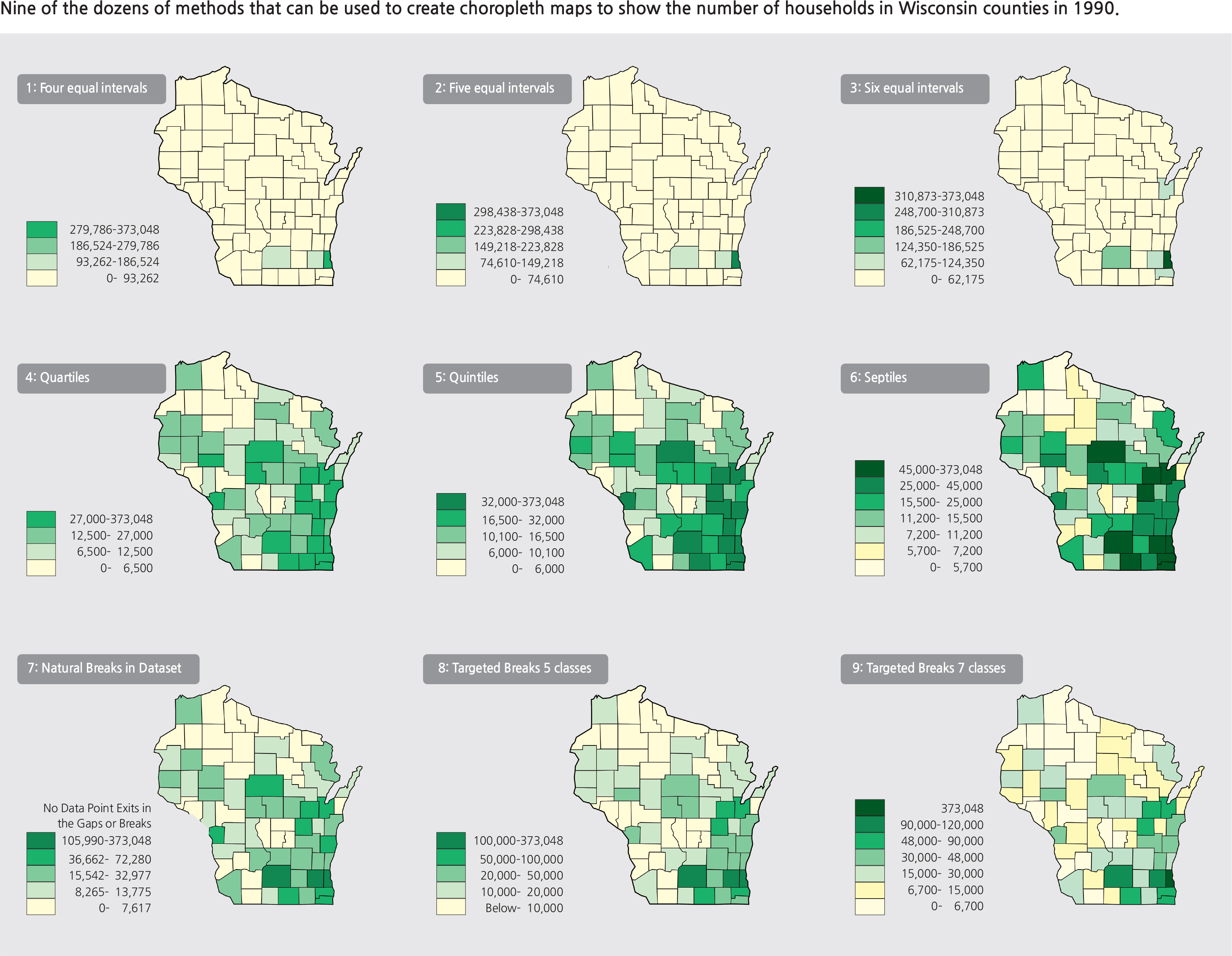
As the discussion of accuracy of representation continues, the main question that can be asked is whether a cartographer is mapping the true geography of the land or simply mapping a set of data that is conveniently available. A map reader should train himself/herself to recognize the difference. It may not be an easy task, but taking the context of other geographic factors and other supporting maps or geographic information and then applying spatial thinking skills is critical in truly understanding the intended message of the map. Researchers have already shown that secondary school students are capable of achieving some skills in understanding thematic maps; among the researchers are Castner, Gerber, Liebens and Downs, Gersmehl, Lee and Bednarz, Huynh and Sharpe, Duarte, and Chu et.al (see Reference and Bibliography below). The 2006 publication by the U.S. National Research Council, Learning to Think Spatially: GIS as a Support System in the K-12 Curriculum, should be used by teachers as a reference and consultation for their efforts in developing lesson plans or for creating spatial thinking exercises. Four lesson plans developed by a team of U.S. experienced geography teachers from maps and other materials in The National Atlas of Korea Volume I have been taught in classrooms for two years to over 800 students in Utah, Minnesota, Tennessee, Georgia, and several other states with success (Chu et.al.; 2016). These lesson plans can be downloaded by any teacher for use in their classroom since they are in the public domain (http://nationalatlas.ngii.go.kr/). Developing spatial thinking skills should begin at the middle and high school levels.
Reference and Bibliography Castner, Henry. 1983. “Research in Cartographic Communication: Any Implications for Introducing Maps and Mapping to Young Children?” The Operational Geographer. 2:13-16.
Castner, Henry. 1987. “Education through Mapping/A New Role for the School Atlas?” Cartographica. 24:82-100.
Choe, B.N.. 2014. National Atlas of Korea I, II, III. National Geographical Information Institute, Seoul, Korea (http://nationalatlas.ngii.go.kr/.)
Chu, Gregory, Jongnam Choi, Chul Sue Hwang, Doug Andersen, Kenneth H. Keller, Michael Robinson, Kelly Swanson. 2016. “Teaching Spatial Thinking with The National Atlas of Korea: A Valuable Resource for Advanced Placement Human Geography.” National Council for Geographic Education. The Geography Teacher. 13:4:166-178.
Duarte, Ronaldo Goulart. 2015. “Spatial Thinking and School Cartography in Brazilian Middle School: Running an Assessment Test” (full paper). Proceedings of the 2015 International Cartographic Conference. Brazil. International Cartographic Association.
Gerber, Rod. 1995. “Children’s Understanding of Graphic Representations of Quantitative Data.” Learning and Instruction. Elsevier. 5:1:77-100.
Gershmehl, Philip. 2008. Teaching Geography. 2nd ed. New York. Guilford Press.
Huynh, Niem Tu, and Bob Sharpe. 2013. “An Assessment Instrument to Measure Spatial Thinking Expertise.” Journal of Geography. 112:1. 3-17.
Jenks, George F. 1967. “The Data Model Concept in Statistical Mapping.” International Yearbook of Cartography. 7:186-190.
Kimerling, A. Jon, Aileen Buckley, P. Muehrcke, J. Muehrcke. 2016. 8th ed. Map Use: Reading, Analysis, Interpretation. ESRI Press. 666 pages.
Muehrcke, Phillip. 1978. 1st ed. Map Use: Reading, Analysis, Interpretation. JP Publications, Madison, WI. 469 pages.
Lee, Jongwon, and Robert Bednarz. 2012. “Components of Spatial Thinking: Evidence from a Spatial Thinking Ability Test.” Journal of Geography. 111:1. 15-26.
L i b e n s , Ly n n S . a n d R o g e r M . D o w n s . 1 9 8 9 . “Understanding Maps as Symbols: The Development of Map Concepts in Children.” Advances in Child Development and Behavior. Elsevier. 22:145-201.
National Research Council (NRC). 2006. Learning to Think Spatially: GIS as a support system in the K-12 curriculum. Washington, D.C. National Research Council Press. 313 pages.
Wright, John K. 1936. "A Method of Mapping Densities of Population with Cape Cod as an Example." Geographical Review. 26: 103-110.
