Just like any country, assets of the wetlands and national geoparks of Korea need to be protected. Conservation and preservation efforts are important in helping to sustain a balance between the environment and economic developments. Korea is blessed to have large numbers of geologic structures that are of high value for researchers and tourists alike. In addition, there are also thousands of
uninhabited islands. While these islands may be unoccupied, they serve a myriad of important purposes.
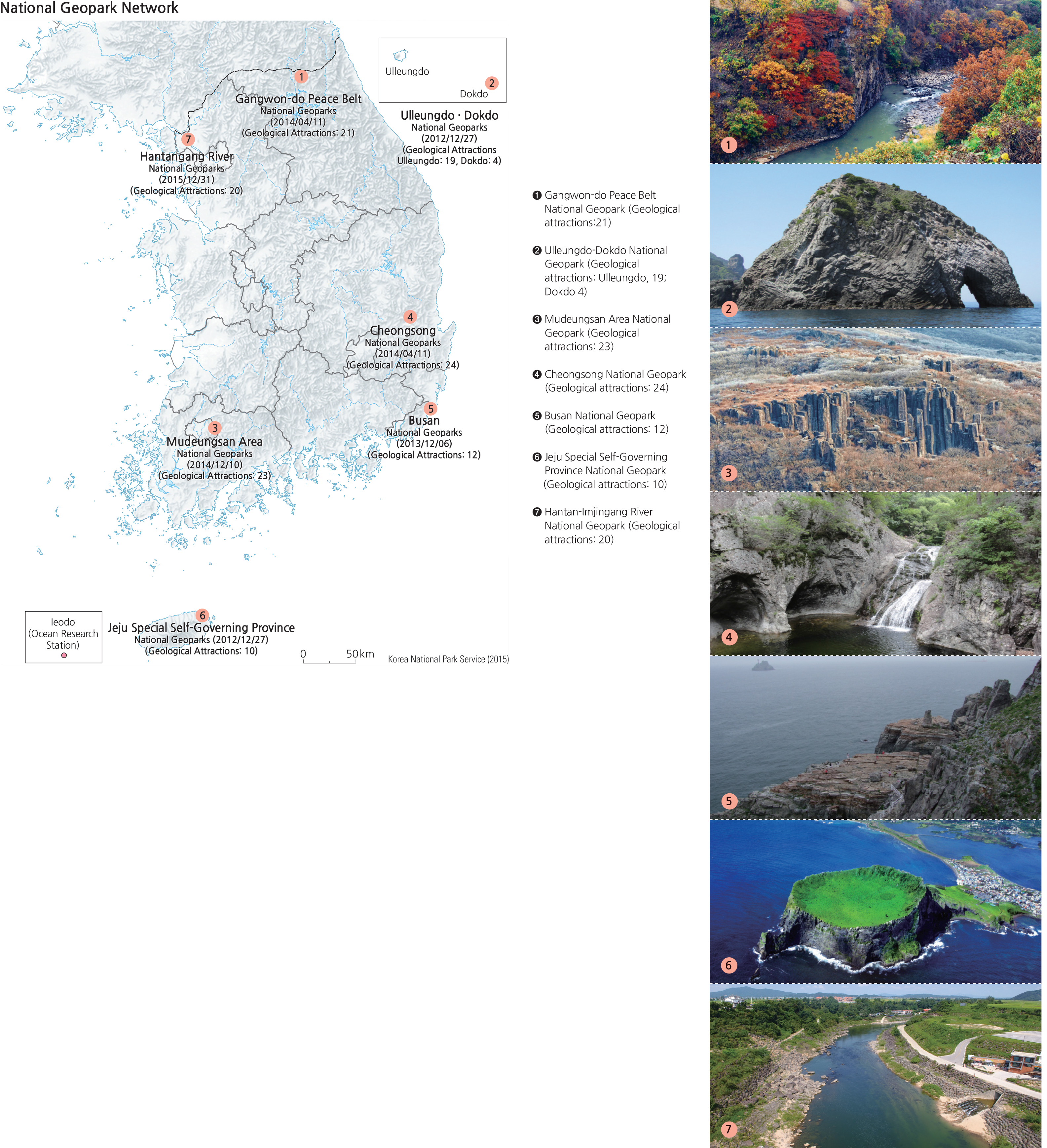
National Geoparks target areas with geological and geomorphologic significance to carry out conservation activities that meet the criteria globally prescribed in a particular country (in Korea, the Ministry of Environment certification). National and World Geoparks are almost identical in their assessment and certification procedures, management structures, and operating systems. As of 2016, Korea operates these seven National Geoparks: Jejudo, Ulleungdo-Dokdo, Busan, Gangwon Peace Geopark, Cheongsong-gun, Mudeungsan, and Hantangang-Imjingang. Many more candidates are waiting to be designated.
The entire island of Jejudo, with its diverse volcanic landforms and geological resources, is a National and International Geopark. As the first National Geopark of Korea, Jejudo is often referred to as a “museum of volcanoes” as it boasts a variety of unique volcanic landforms. There are 368 cinder cones, termed oreums,
above the surface and about 160 lava tubes and caves that are located underground. It is a rare phenomenon to see so many oreums, caves and lava tubes on one small island.
Ulleungdo and Dokdo, each a part of the Ulleundo-Dokdo National Geopark, are volcanic islands that provide essential clues explaining the formation of the East Sea. They are very important in various research fields including geology, biology, oceanography, and history. Seonginbong (986.7 m)—the highest peak of Ulleungdo—is located at the center of the island. Ulleungdo also has the Nari Basin, formed by a depressed caldera, and small peaks in Albong. Some other geosites of Ulleungdo and Dokdo include Dodong and Jeodong Beaches that have well-developed sea cliffs and wave-cut platforms; Gooksu Rock with its columnar joints; and other unique sites such as Daepoonggam, Elephant Rock, Turtle Rock, Bongrae Waterfall, Songgot Peak, Seonginbong Primitive Forest, and Mongdol Beach. There are a total of 23 geosites on these two tiny islands.
Busan National Geopark has a variety of diverse landscape features such as coasts, mountains, and estuaries. Consequently, it has a rich geo-heritage and a wealth of cultural assets. Nakdong Estuary, Songdo Peninsula, Taejongdae, Oryukdo-Igidae, Changsan, and Geumjeongsan are some of the 12 geosites in Busan National Geopark.
Gangwon Peace Geopark was designated in order to transform the areas around the DMZ from a symbol of Cold War hostility to a symbol of peace. It contains a rich geological and geomorphological heritage, and spans across Cheorwon-gun, Hwacheon-gun, Yanggu-gun, Injegun, and Goseong-gun. There are 21 geosites, including the Cheorwon Lava Plateau, Haean Basin (Punch Bowl), Potholes of Naerincheon, and Hwajinpo Lagoon, among others in the Gangwon Peace Geopark.
Cheongsong Geopark is famous for its magnificent landscape and plenty of historical, cultural, ecological, and archaeological heritage sites. Among 24 geosites, major locations include Yongchu Waterfall, Jeolgu Waterfall, Yongyeon Waterfall, Dalgi Waterfall, Juwang Cave, and Cheongsong Ice Valley.
Mudeungsan Area Geopark is located in Gwangju, Hwasun-gun, and Damyang-gun. It has 23 geosites such as the Seosokdae Columns and the Seoyuri Dinosaur Fossil Site, and 22 cultural heritage sites such as Mujin Goseong and Unjusa Temple.
Hantangang-Imjingang Geopark includes Jaein Waterfall and Jwasang Rock of the Mesozoic Era, Jeogbyeok Columnar Joint, Dangpo Castle, Yeoncheon Jeongok-ri Prehistoric Site, Baegeui-ri Sedimentary Layer, Dongmakri Tuff, Pillow Lava in Auraji of Yeoncheon, Hwajeokyoun Pond, Art Valley, and Gurai Valley in Pocheon-si. It has 20 geosites and a total area of 767 square kilometers.
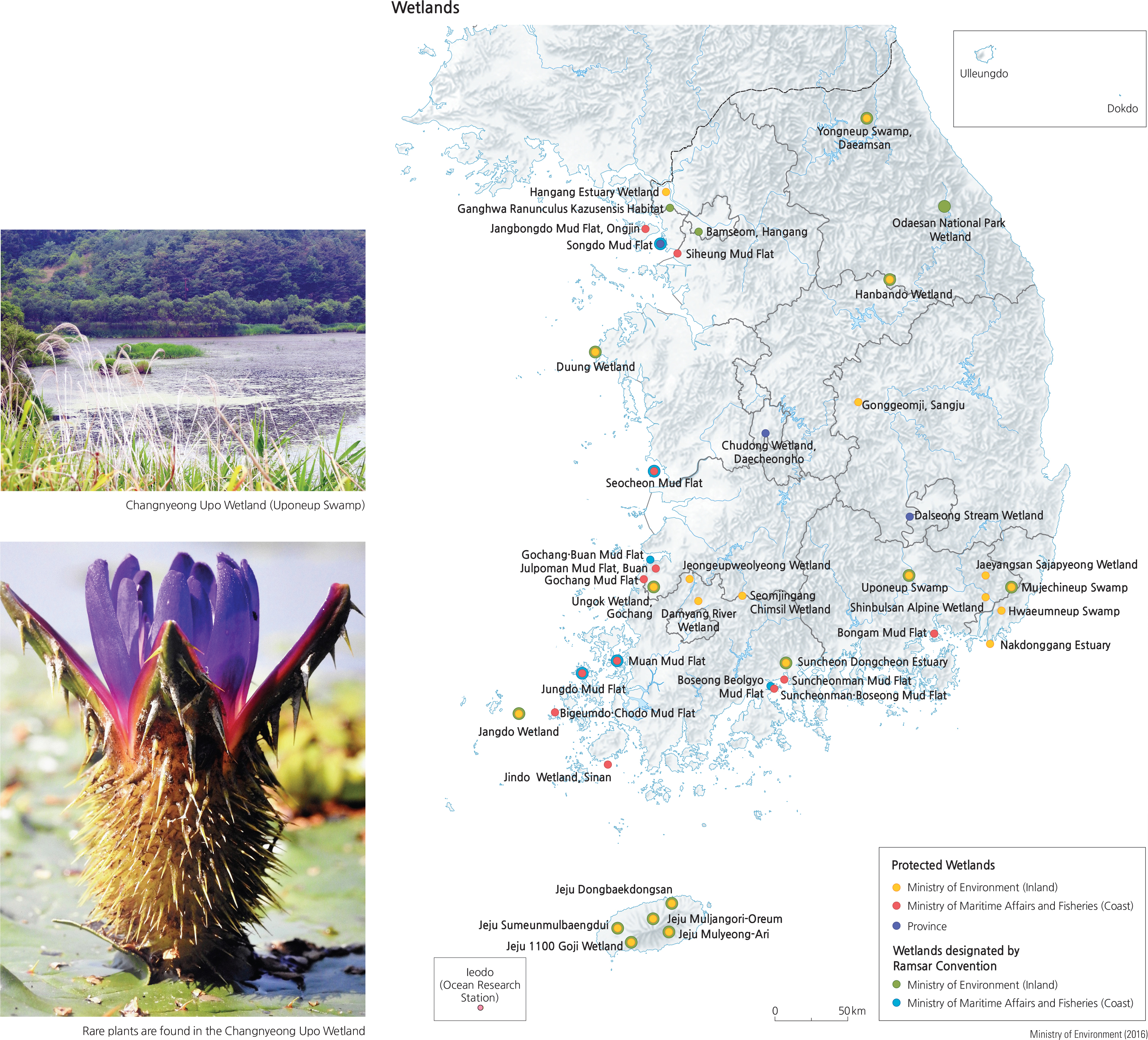
Wetlands are a haven for biodiversity and provide an ecological buffer zone for hydrological and atmospheric processes. Korea has been conducting wetland monitoring in an effort to select certain wetlands as subjects for its conservation plans. Currently, 22 protected wetlands (with a total area of 126.28 square kilometers) have been designated by the Ministry of Environment. Additionally, twelve wetlands along the seaside (with some 225.17 square kilometers) have been named by the Ministry of Ocean and Fisheries, and seven wetlands are protected by other regions and provinces (covering 8.254 square kilometers). The Convention on Wetlands of International Importance (the Ramsar Convention) took place in Ramsar, Iran in 1971 and was enacted in 1975. It was intended to protect internationally important wetlands that function as habitats for animal and plant wildlife—waterfowl in particular. By 2015, 169 countries had joined the Convention, and Korea has been a member since 1997. There are 22 registered wetlands in Korea that are recognized by the Ramsar Convention, notably including: Gangwon-do Daeamsan Yongneup Swamp, Changnyeong Uponeup Swamp, Jangdo Wetland and Suncheonman in Jeollanam-do; Chungnam Taean Duung Wetland, Ulsan Mujechi Wetland, Muan Tidal Flat, Ganghwa Maehwamareum Habitat, Odaesan Wetland, Yeongwol Hanbando Wetland, Mulyeongari, Muljangori-Oreum, and Sumeunmulbaengdui in Jejudo.
Among the 3,167 islands of Korea, all accessible and large islands are occupied by residents while 2,675 small remote islands remain uninhabited. Uninhabited islands are important to national territory and economics, as they are pivots for defining base points for national sovereignty boundaries and exclusive economic zones. From an ecological and environmental perspective, uninhabited islands are protected from human disturbance, so their conservation status is higher than that of inhabited islands. From an academic point of view, uninhabited islands have special geologic, topographic, landscape, and ecosystem features that provide opportunities to investigate changes in climate, land surface features, sea levels and much more. Uninhabited islands are more affected by ocean currents and sea waves, thus providing easier observation of various coastal topographic features that result from erosional and depositional processes. Erosional landforms such as wavecut platforms, sea cliffs, sea caves, sea arches, sea stacks, and notches are dominantly located where the rocky coasts of uninhabited islands meet the open sea. By contrast, islands located in inland seas often have beaches and tidal flats.
Under the Act on the Conservation and Management of Uninhabited Islands, established in 1997, conservation efforts have been carried out for uninhabited islands with particular landscape value or ecological importance. By 2014, 1,170 islands had been studied, of which 219 are registered as special islands for conservation. These special islands are mainly located in Jeollanam-do and Gyeongsangnam-do, as rias coasts (coasts with inlets) are very prominent in these regions.
Brief Interpretation of the Maps
The National Geopark Network map shows all seven geoparks are relatively evenly distributed in the country with one situated on Dokdo and one on Jejudo as islandbased geoparks. Two of the remaining five are close to the DMZ and the other three are scattered to allow access from much of in the country. The locations of wetlands, as can be easily imagined, are away from the mountainous areas where the flow of water can be slowed down to accumulate on coastal lowlands and flat valleys. Generally, most of the wetlands can be found in the southern half of Korea with a few exceptions in the northeast and in areas around the capital region of Seoul. While geoparks have a high value for their geologic formations and natural wonders that attract visitors, wetlands serve a different purpose−that of conservation. Wetlands have the ability to rejuvenate battered environments, mitigate some water pollution, attract waterfowl and harbor native wildlife and rare flora. Geoparks, wetlands, and uninhabited islands are environmental assets to a nation; there is a need to protect and preserve them.
While there is no UNESCO designated geoparks in the United States listed in the Global Geoparks Network, national parks, national monuments and other designations administered by the U.S. National Park Service serve the same function as UNESCO geoparks. Describe your own experience from visits to (or your own desire to go to) national parks of your country. What can you learn from visits to national parks? Why is it important to preserve national parks and places of beauty?