The environmental setting of Northeast Asia is unique because peninsula and island nations are directly tied to environmental conditions in continental Asia. Environmental problems will transcend political boundaries and affect other nations. This is why all nations in this geographic realm need to study and monitor grave environmental effects that may cause long-term or even irreparable damage. International cooperation has become vital in mitigating regional environmental issues.
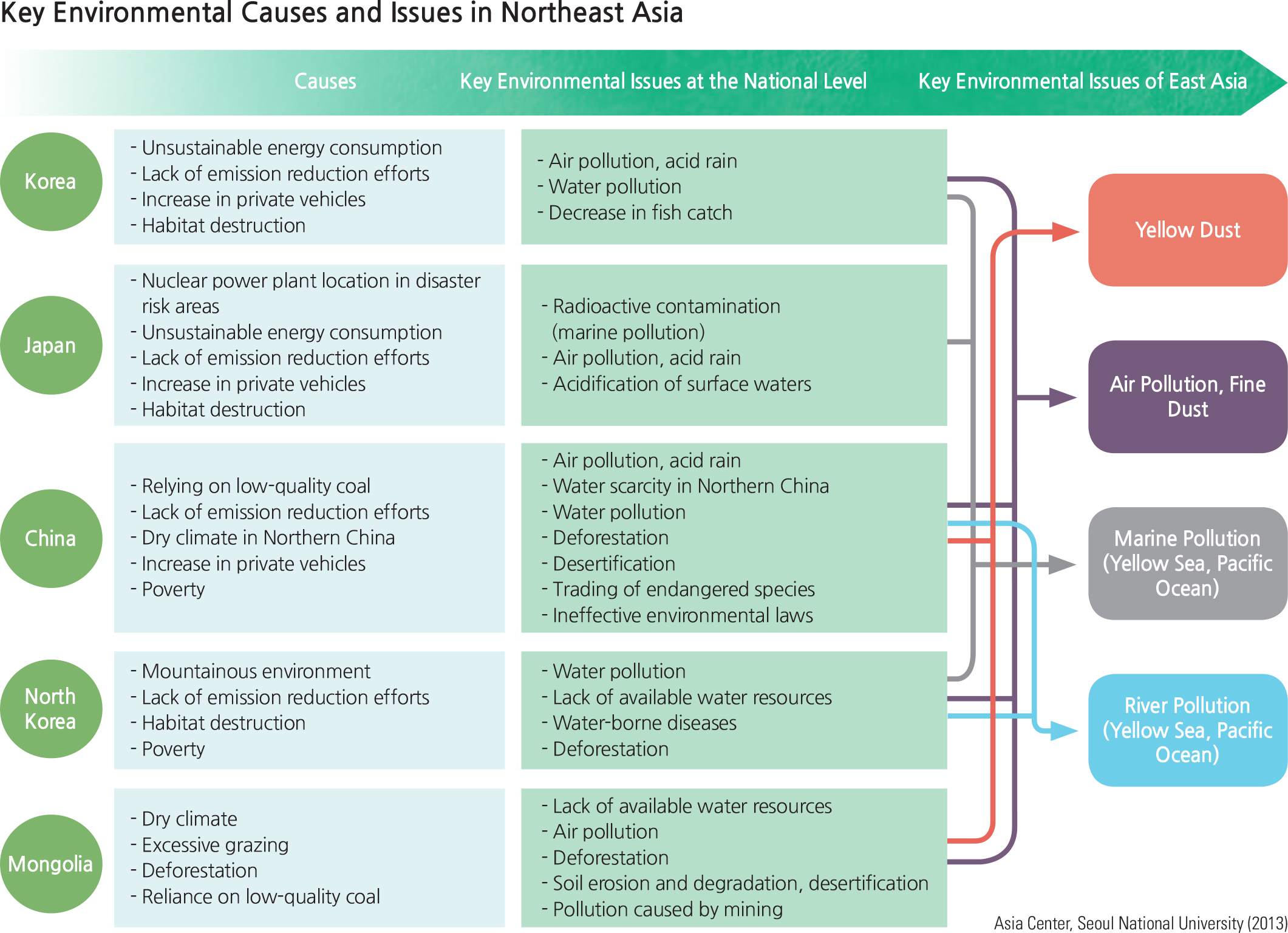
Every country in Northeast Asia faces different environmental challenges according to their natural environmental conditions and socio-economic factors. Korea and Japan share environmental problems that can generally be seen in developed countries; their advanced industrial structures have led to increases in energy consumption and the number of private vehicles. On the other hand, North Korea and Mongolia experience environmental problems that are brought about by poverty. In particular, North Korea is undergoing serious environmental damage as a consequence of forest degradation due to food and energy shortages. Mongolia and western China are affected by desertification and aridity due to their dry climate, while recent rapid industrial development in eastern China has caused serious air and water pollution.
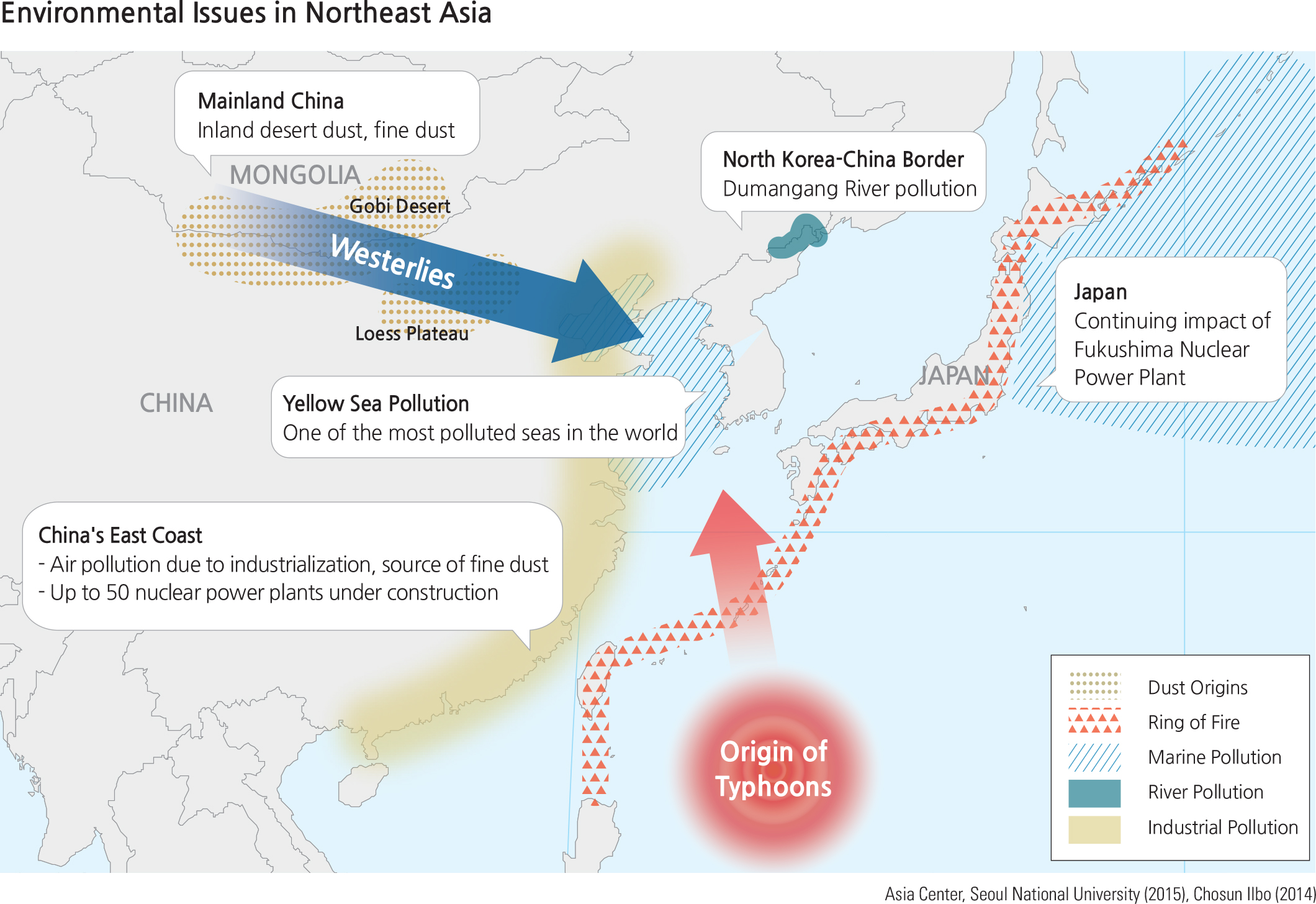
Such environmental problems in Northeast Asia are linked in diverse ways, and their consequences are influential across countries. For instance, yellow dust originating from the Gobi Desert and the Loess Plateau picks up pollutants such as fine dust and nitrogenous compounds as it crosses the rapidly industrialized east coast of China. It then rides the westerly winds and reaches Korea and Japan. The pollution of international seas and streams such as the Yellow Sea and Dumangang (river along the border between North Korea and China as well as Russia) is also being discussed as constituting some of the most important environmental issues in this region.
Not only is Northeast Asia located on the same plate boundary, it also shares the risks of various disasters, which can be carried by westerly winds, currents, and typhoons. With an increase in risk factors such as the growing number of nuclear power plants in eastern China, the future of Northeast Asia is projected to be even more vulnerable to environmental disasters.
Responding to yellow dust that originates from the Gobi Desert is an important environmental task for not only Korea, but also the entire Northeast Asian region. Korea has actively pushed for a collective response to this issue, regarding it as a major agenda in national summits such as the Environmental Cooperation Channel in Northeast Asia and the Tripartite Environment Ministers Meeting (TEMM) composed of Korea, China, and Japan. Experts from Korea, China, and Japan have conducted collaborative research in two areas in Hulunbuir, Inner Mongolia, China. The first round of research was conducted from late of July to early August 2013, with a follow up in July 2014. This research will be used as a foundation for ecological restoration efforts in areas undergoing desertification.
The Tripartite Environment Ministers Meeting is now an annual meeting that was first proposed by the Korean government in 1992. Its objective is to devise cooperative measures to tackle East Asian environmental issues such as yellow dust, acid rain, atmospheric pollution and hazardous waste management, and to raise a sense of environmental community among the three countries. This meeting is the only minister-level conference in the East Asian region and has served as the highest-level coordination mechanism on environmental cooperation. A total of 18 meetings had been held by May 2016.
Brief Interpretation the Map
The Environmental Issues of Northeast Asia map clearly shows the long distance relationships between environmental conditions from interior continental Asia with countries in the Northeast Asia Realm. Environmental problems can cross international boundaries and create problems for another country. The map demonstrates why all countries in the region need to work together to mitigate and/or alleviate such environmental problems.
Air pollutants from the industrial area of an upwind country may include chemically soluble gases and dusts. What happens when too much of these pollutants are carried by wind over a sea or an ocean and pick up moisture before reaching a downwind country? What might be a possible outcome of its effects on the agriculture and the soil of the downwind countries?
Spatial Technology and Environment
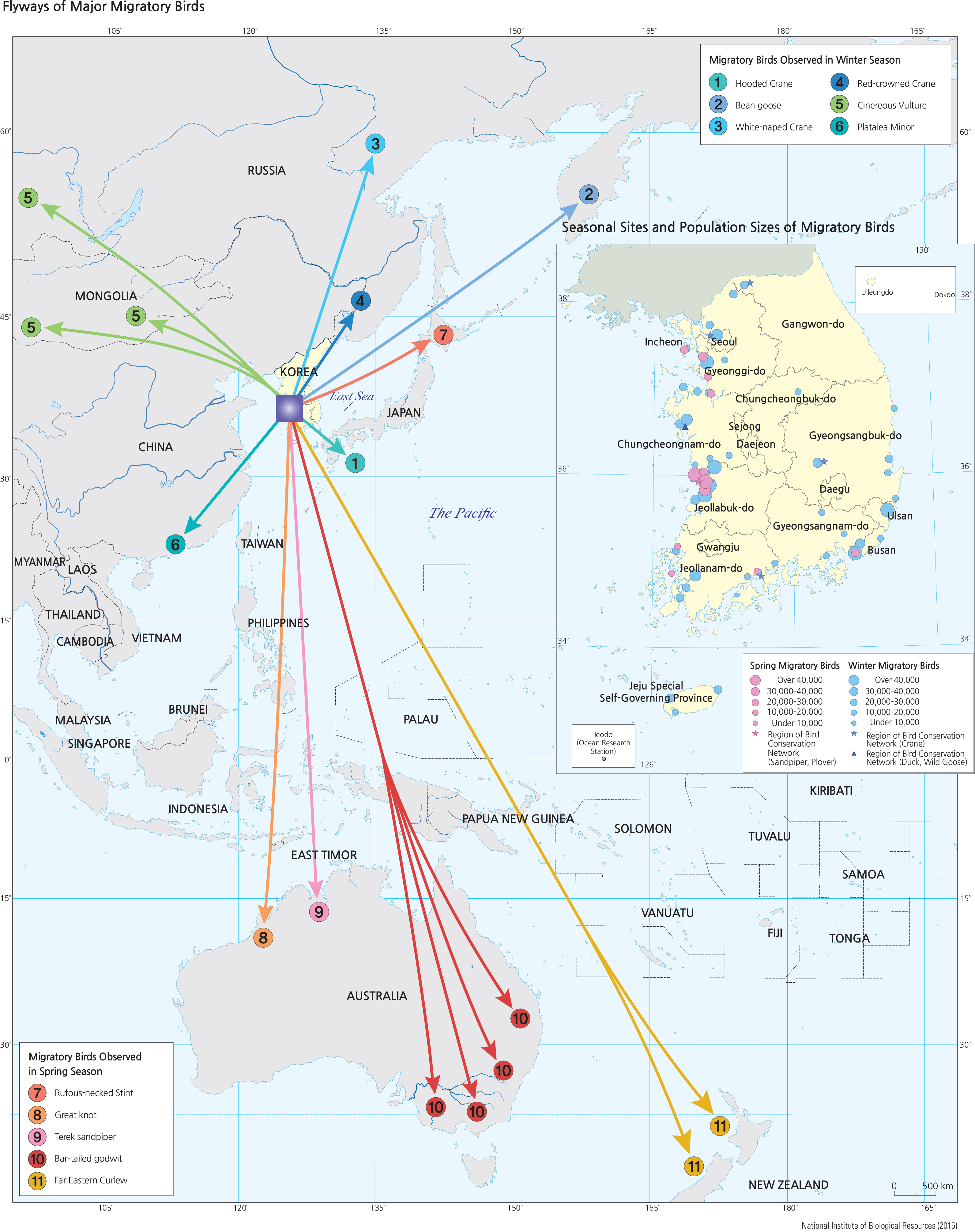
While environmental issues can transcend international boundaries, spatial technology has provided us with instruments and techniques to study positive environmental phenomena. One such phenomenon relates to winter/ summer migration of birds. Birds can also transcend international boundaries and fly great distances for their own survivals. The use of Geographic Information Systems (GIS) and Global Positioning Systems (GPS) has enabled geographers and biologists to track the flight path of migratory birds, in order to understand their adaptation to adverse environmental conditions.
Many migratory birds that are internationally endangered visit and use the Korean Peninsula as over-wintering sites, breeding sites, and stop-over sites. In particular, shore birds that spend winter in Australia and New Zealand and then migrate to Siberia for breeding stop to feed in the tidal flats of the west coast of Korea during spring and autumn. Sandpipers and plovers visiting South Korea follow the East Asia-Australia Flyway (EAAF), one of the 9 major flight paths used by migratory waterfowls in the annual bird migration for breeding and wintering. It has been reported that 35 species of globally endangered waterfowl, 13 species of near-threatened waterfowl, and 50 million birds belonging to more than 250 population units travel along the EAAF.
Brief Interpretation of the Map
While it is estimated that 50,000,000 migratory birds visit nesting, breeding and feeding sites in South Korea annually, the size and location of the recorded sites are relatively small. Most of the sites are islands and near inland sites along the Yellow Sea coast. There are also some sites along the southeast coast, on islands and on the coast extending northward to Ulsan.
Study closely the locations of the migratory sites on the northwest coast south of Incheon. As noted earlier on page 47 (also later on pages 130–31) of this volume, this coastline is also the location of major sea reclamation sites for a combination of tidal power projects, and agricultural and urban development. Discuss the environmental conflicts resulting from this type of reclamation in coastal areas. Think about how planning and development decisions in the creation of these reclamation sites might alleviate some of the environmental problems. Are there any land uses that will result from reclamation in bird frequented sites that cannot be avoided?