The terrain of Korea is characteristically high along the east coast and low along the west coast. Consequently, most of the rivers flow into the Yellow Sea and the South Sea. The shoreline of the east coast is smooth and rivers flowing into the East Sea are relatively short and steep-sloped. On the other hand, the shoreline of the west coast is more complex with lots of indentations, offshore islands, and deltas. Many rivers flowing to the western and southern coasts are relatively long; they have gentle slopes and wider basins that result in higher amounts of discharge. In these areas, river sediments shape extensive alluvial plains and alluvial basins; meandering channels are often formed as well.
In Korea, there are five large rivers: Nakdonggang, Hangang, Geumgang, Seomjingang, and Yeongsangang (“ang”is the Korean word for rivers). Several mid- to small-scale rivers are also found in the country, including Anseongcheon (“heon”is the Korean word for midto small-scale rivers), Sapgyochun, Mangyeonggang, Dongj ingang, and Hyeongsangang. In order to systematically manage river and water resources, the rivers have been divided into 117 sub-basins. Hangang has the largest drainage area of 35,770 km2 (including its portion in North Korea). It also has an annual runoff volume of 16 billion cubic meters, which constitutes 35.1% of the nation’ total runoff volume. The longest river in Korea is Nakdonggang, with a length of 510 km.
From 2005 to 2014, the average annual precipitation in Korea was approximately 1,323.7 mm, which is equivalent to about 1.6 times the world average. This is enough to classify Korea as a high rainfall region even though seasonal variability is extremely high. Due to seasonal rain and typhoons, 735.8 mm of rainfall (55.6% of the annual rainfall) occurs in the summer and often causes floods. Furthermore, rainfall has the tendency to quickly collect in rivers as over 70% of the land is mountainous with an average slope of about 20%. These geomorphic and climatic characteristics cause high fluctuations in the discharge rate of rivers throughout the year, often causing extensive floods and severe droughts.
The coefficient of river regime indicates the ratio between the maximum and minimum flow of a river. Seomjingang currently has a coefficient of river regime of 270, which is the highest among the five large rivers of Korea. Before the installation of dams, each of the five large rivers had coefficients of river regime that were higher than 300. In particular, Seomjingang and Yeongsangang displayed
extremely high levels at around 700. Consequently, dams and reservoirs were actively constructed to ensure the reliability of water resources, reduce flood damage, and mitigate the effects of drought. Intensive plans were also implemented to conserve river banks and their surrounding areas.
As the nation grows, accompanied by population increases, the need for transportation infrastructure, and high rates of urbanization, rivers and watersheds need to be protected. Given the complex nature of human interaction with the land that involves the building of dams and usage of water for home consumption, agriculture, and industry, water resources need to be sustained. The government proceeded to develop policies on the usage of water, river management efforts, and plans for maintenance.
A River Master Plan is a comprehensive river maintenance, conservation, and utilization plan for the functional sustenance and prevention of natural disasters in
river systems.
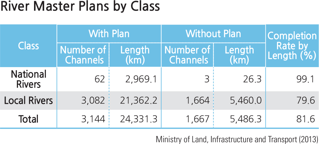
Based on the River Master Plan, river banks are established to prevent flooding by calculating the area of cross-section depending on flood discharge standards for each river. By December 2013, 52.1% of the total length of legally designated rivers had completed river bank maintenance. Newly established banks are required by 23.1% of all river areas, among which 3.8% are for national rivers, while 48.9% are for local rivers.
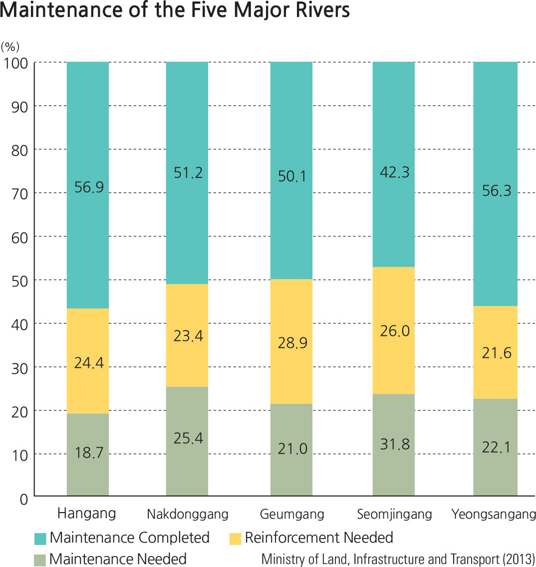
Among the five major rivers, Hangang displays the highest percentage of maintenance completion at 56.9%, followed by Yeongsangang at 56.3%. Geumgang has the highest percentage of reinforcement needed (28.9%), while Yeongsangang comes last (21.6%). Seomjingang requires the most new infrastructure (31.8%), while Hangang needs the least (18.7%). By municipal district, Seoul has the highest percentage of maintenance at 95.8%, followed by Gwangju (87.1%) and Daegu (76.3%). Sejong shows the highest percentage of reinforcement needed at 34.4%, followed by Chungcheongnam-do (30.8%) and Jeollabukdo (29.2%). Districts that need the most new infrastructure are Incheon (45.6%), Jeollanam-do (32.2%), and Jeju Special Self-Governing Province (31.5%).
In terms of small-scale rivers, records indicate that 43.1% of a total of 22,823 rivers in Korea have been maintained. Daegu had the highest rate of small-scale river maintenance at 67.5%, followed by Daejeon (60.1%), Gwangju (60.1%), and Seoul (54.1%). On the other hand, Jeju Special Self-Governing Province has a small-scale river maintenance rate of only 20.9%.
Brief Interpretation of the Map
With a high average rainfall (1.6 times the world average) and a river ratio of over 700 (ratio of maximum to minimum flow), watershed management is of critical importance to South Korea. The primary reasons for watershed management are to decrease the effects of flooding in the mainly summer rains and to provide a stable water supply for Korea's increasing population. The development of adequate watershed management systems is a large task that is accomplished over
many years. Each of the regions judge that their management process is just over half complete and well maintained with the balance about evenly divided between needing maintenance and needing reinforcement stages.
Each of the five major watershed management regions contains at least one major dam. The dams in these regions are located in different areas of the region. Some are nearer the headwaters and some very near the coast. Can you project the different functions of the dams by the geographic locations? Flooding in Korea is a major concern because of the concentration of rainfall in the late spring and summer. In addition the rivers on the east side of the country are shorter and rise nearer the coast, while on the west side they are longer and display a much more complex drainage system. If you were charged with proposing a new flood control dam in each management region, where you chose to construct it?
River Management
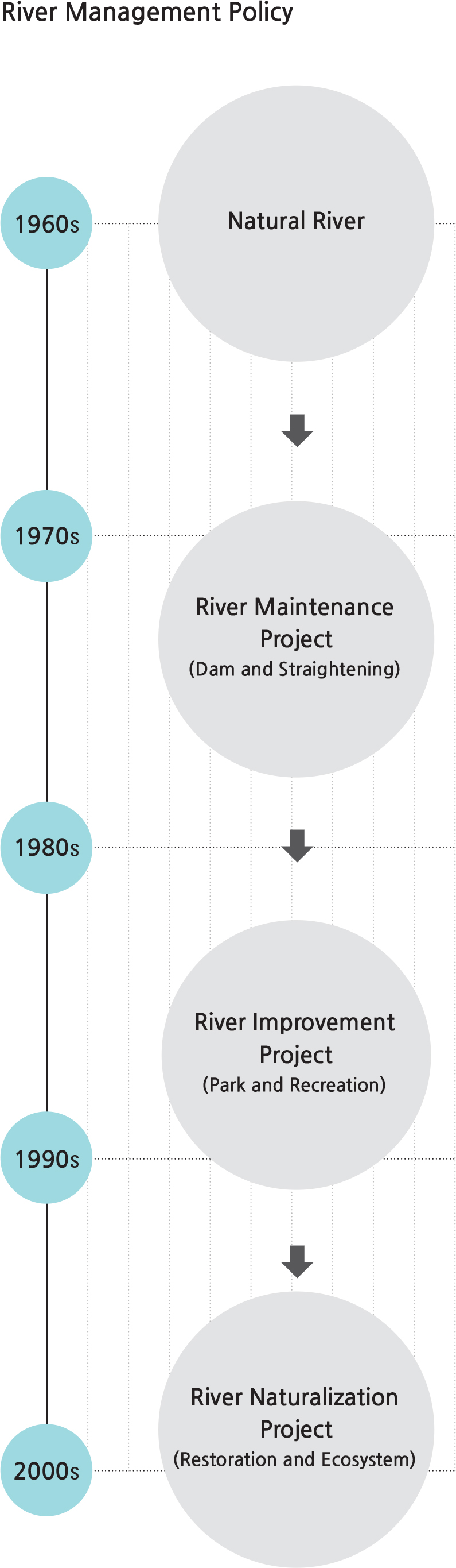
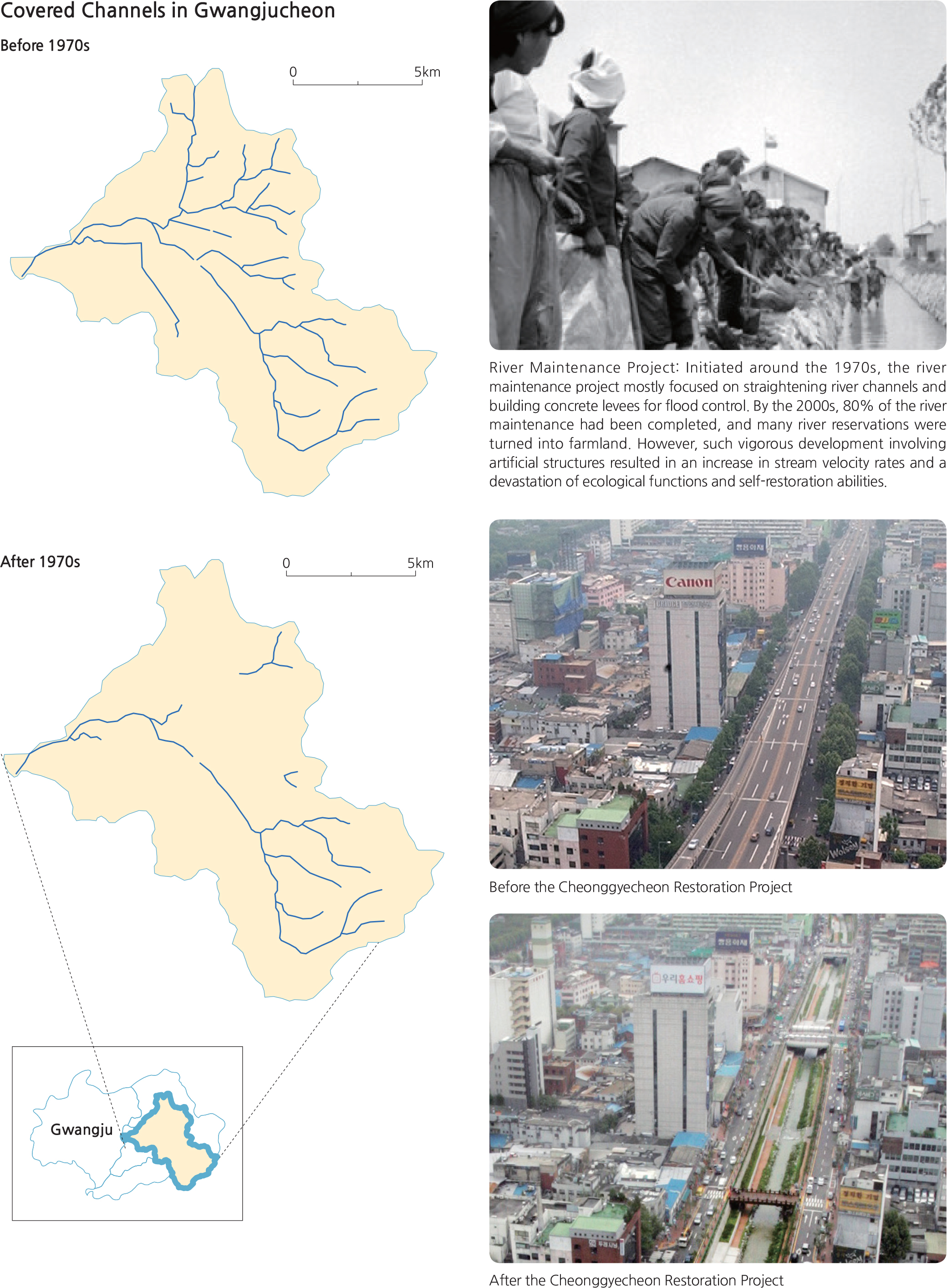
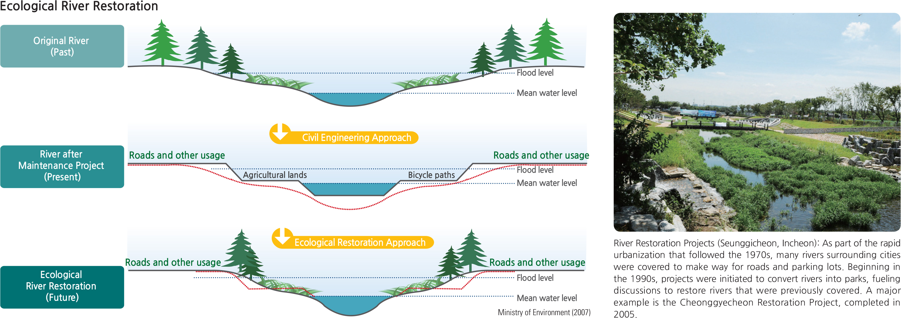
Up until the 1950s and 1960s, most rivers in Korea were in their natural form. However, due to the rapid urbanization of the 1970s, many tributaries were covered or revamped and meandering channels were straightened out in rural areas. As a result, the rate of water flow and discharge become more rapid and larger amounts of sediments are washed downstream. As such environmental issues gained light in the 1990s, various environmental improvement projects (such as the construction of waterfront parks and promenades) were launched in areas around rivers. In the 2000s, the concept of improvement evolved beyond the simple concept of parks to recognize the ecological and scenic conservation value of rivers for ecosystems and humans.
From the before and after photos of the Cheonggycheon Restoration Project, what can you see as the major difference between the before and after photos pertaining to the center of the photos? Discuss the economic, environmental, and public health ramifications of changing a freeway back to a river channel. What are the ecological gains and what are the environmental degradations? Discuss the pros and cons of this project and the gains and losses.
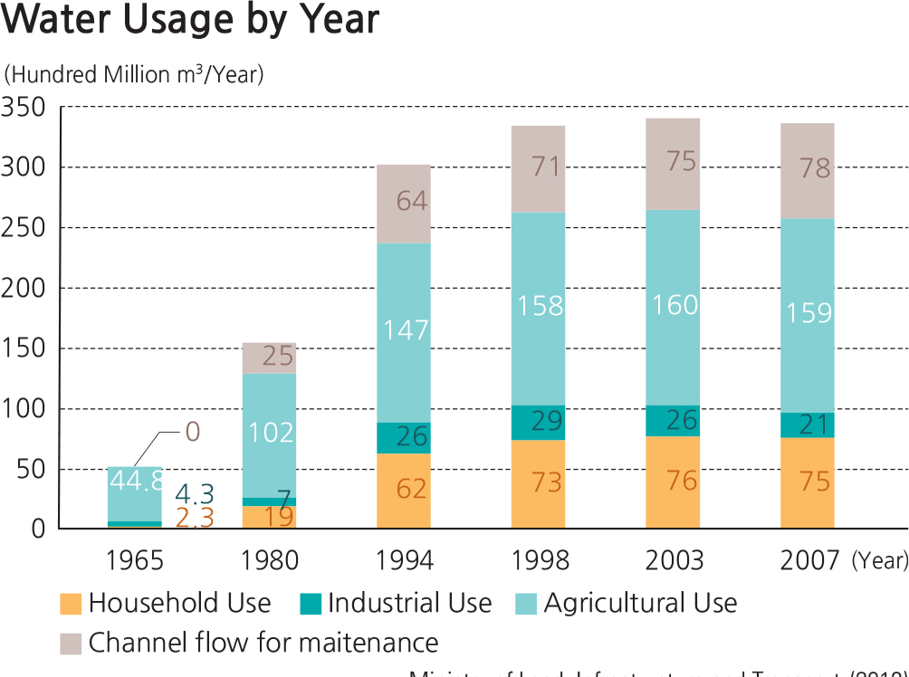
The total water use in Korea increased more than six times from 5.12 billion cubic meters in the 1960s to 33 billion cubic meters in the 1990s. This steep rise can be attributed to population growth, economic advancement, increased industrial development, and an increasing number of irrigation facilities. Accordingly, channel maintenance flow also increased to protect water quality, ecosystems, and landscapes. Since the 2000s, however, the rate of increase for water usage has been slowing down.
In 2007, agricultural use accounted for the largest proportion of total water use at 48%, followed by domestic use (23%), channel maintenance flow (23%), and industrial use (6%). Domestic and industrial water usage has remained about the same since 1998, while agricultural use experienced a decrease over the same time period. On the other hand, channel maintenance flow—hich is used for maintaining river functions—as gradually increased.
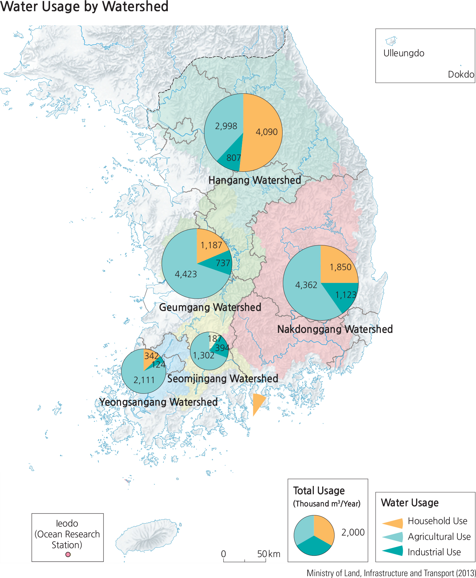
As of 2011, the Hangang Watershed was recorded as the largest area of water use at 5.23 billion cubic meters, followed by the Nakdonggang Watershed (5.1 billion cubic meters), Geumgang Watershed (2.61 billion cubic meters), Yeongsangang Watershed (1.5 billion cubic meters), and Seomjingang Watershed (0.9 billion cubic meters).
In the Hangang Watershed, domestic water use accounted for the highest proportion of water use nationwide at 54.4% due to the large population that inhabits the area, while agricultural and industrial water use amounted to 44% and
1.6%, respectively. For all other watersheds, agricultural water use had the highest proportion, followed by domestic and industrial water use. Large industrial complexes contribute to the relatively high rate of industrial water use in the Nakdonggang Watershed (6.4%), while a smaller population and fewer industrial facilities are responsible for the relatively high rate of agricultural water use in the Seomjingang Watershed (88.1%).
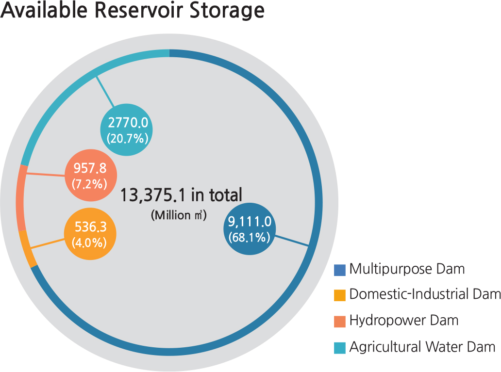
As of 2014, Korea has a total of 17,735 dams and reservoirs, including those under construction. This number includes 20 multipurpose dams, 54 domestic and industrial dams, and 12 hydroelectric dams, with the rest being smallscale agricultural dams. In terms of hydropower capacity, multipurpose dams account for 68.1% of all structures. There are also three dams for flood control: “am for Peace,”Gunnam Flood Control Reservoir, and Hantangang Dam.
The “Four Major Rivers Restoration Project”was launched in February 2009 with the aim to promote local development by building weirs, thus securing water resources, enhancing water quality, and developing the leisure industry. A total of 16 weirs were newly installed on the four major rivers (Hangang, Nakdonggang, Geumgang, and Yeongsangang), and various leisure facilities such as riverside parks and bicycle paths were created as well. However, there are serious ongoing debates concerning water quality degradation and the effectiveness of the project.
Brief Interpretation of the Maps
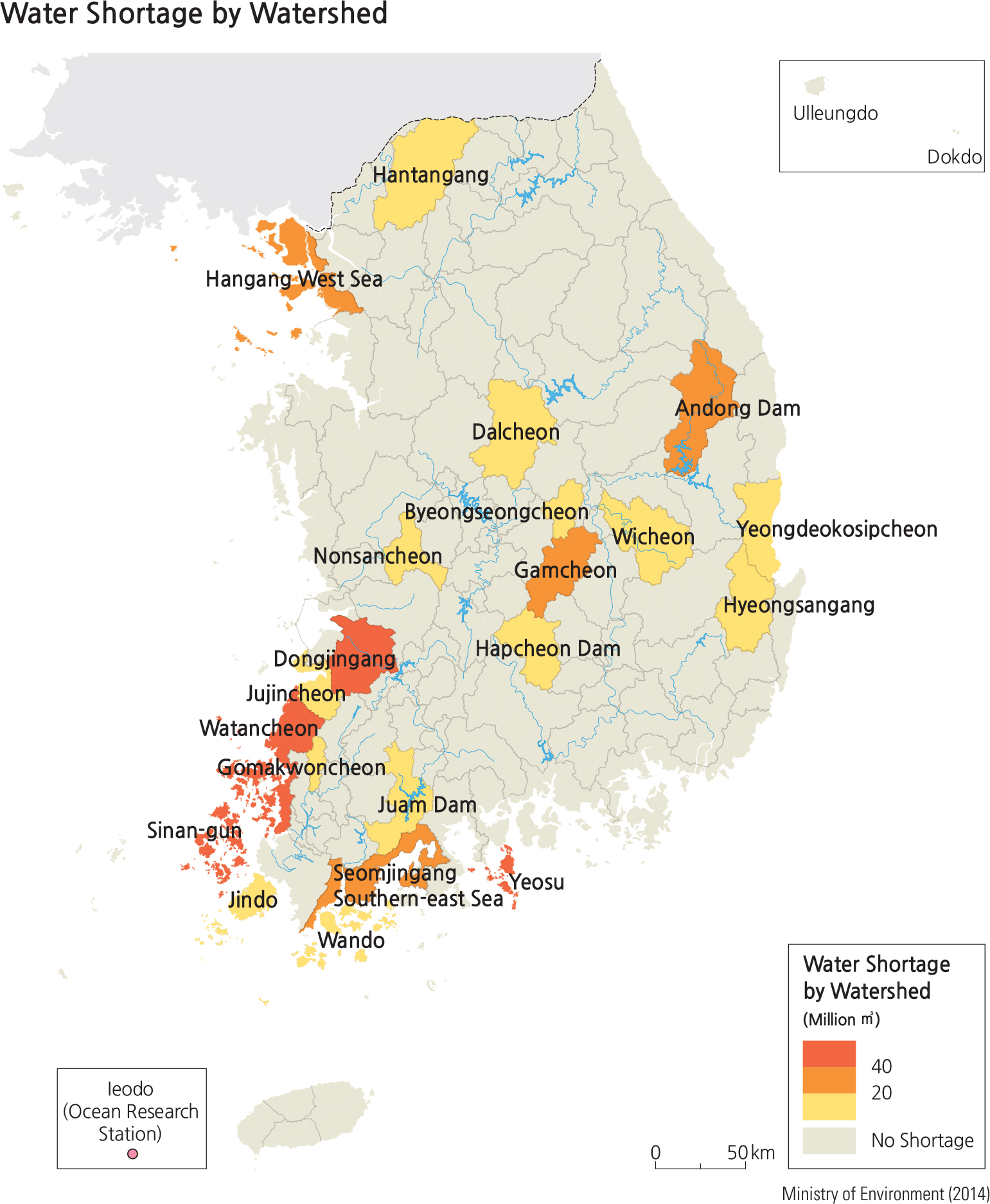
The Hangang and Nakdonggang Watersheds comprise almost two-thirds of the managed watershed land in South Korea, encompassing both mountainous and urban lowland provinces and cities. The remaining three watershed regions are smaller and located in the south and west lowland and coastal areas. Different geographic processes are at work when comparing watershed management and use patterns to the distribution of water shortages by management area. Over half the Hangang Watershed water usage is devoted to domestic use; this is not unusual because this management area includes the large metropolitan areas of Seoul and Incheon. However, the coastal area surrounding Incheon shows a shortage of water that is suggested by deterioration of water quality due to resources and distribution systems. This coastal pattern of water shortage continues on the southwest part of the coast, especially in the island areas surrounding the coast. The islands obviously do not have an extensive riverine catchment to draw upon for their water resources.
The four watershed management areas other than Hangang are dominated by agricultural water use and while they include urban areas, the impact of the water shortages primarily affect agricultural usage. Patterns of water use and associated shortages in different applications are needs that are not easily remedied. The overall water budget for human consumption is largely supplied by natural processes on the supply side and population growth on the consumption side. Efforts at increasing water conservation are important but can only slow demand, and developments in desalinization are prohibitively expensive for agriculture use.
The impact of global warming on rainfall is not well documented other than anecdotal associations with an apparent increase in storms in some areas. If there is actually an increase in major storms, the effect of flooding may offset the usual absorption of water into the soil needed for agricultural production. With an increase in major cyclonic events, how would their frequency affect water availability for agricultural, domestic, and industrial use? With the increasing land reclamation on the west coast of South Korea, how would this process affect the water utilization for domestic uses?