English II
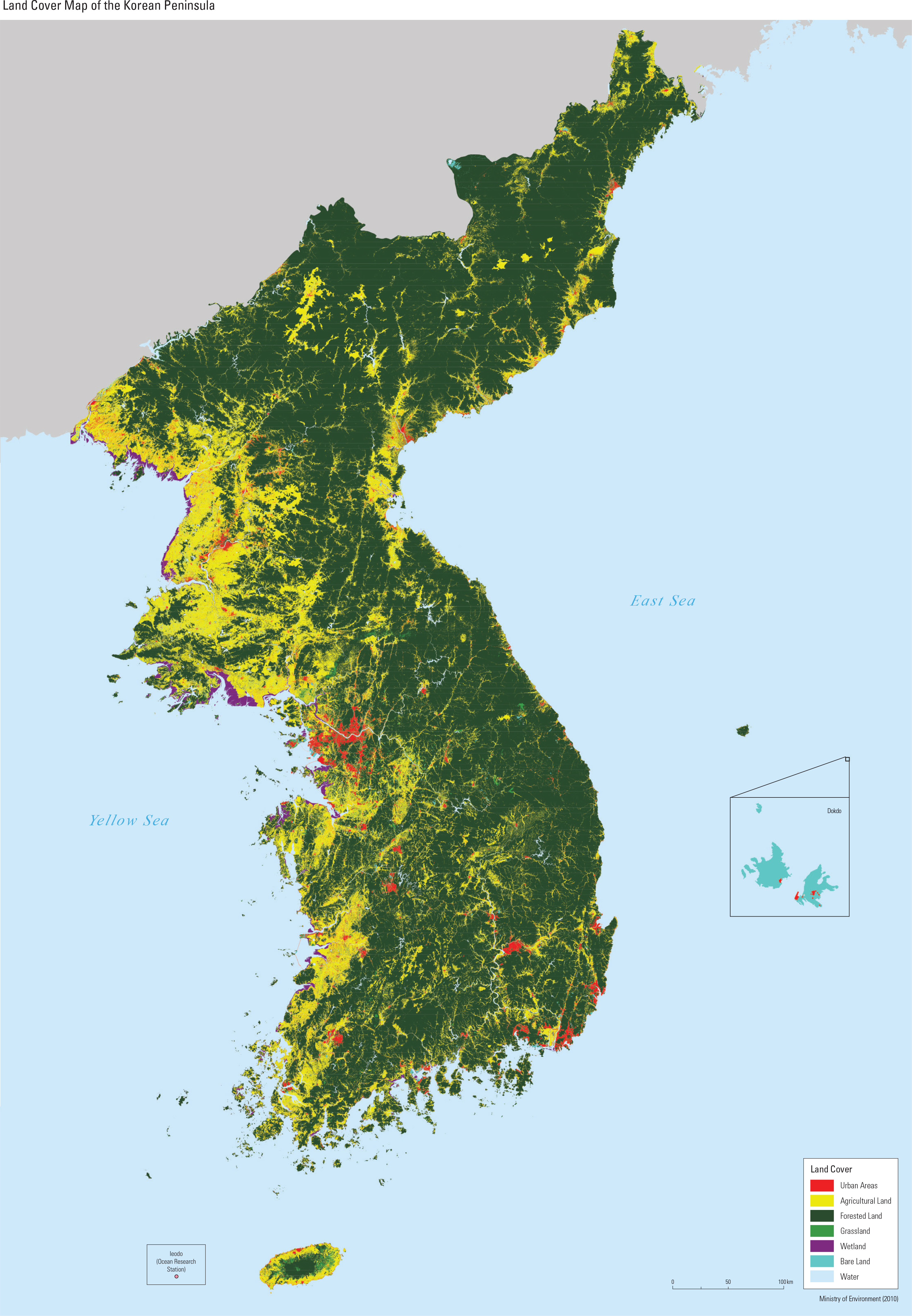
Over a long period of time, Korea has experi- enced various changes in its patterns of land use. Urban construction took root in basins and along major rivers, and cities gradually expanded with the growth of the population. Roads and railways were constructed to connect cities, leading to the further development of new metropolitan centers in surrounding areas. Farmlands for crop pro- duction and pastures for livestock also increased throughout the years. Hills were cultivated for upland farming elds, many of which have been converted into rice paddies through modern irri- gation methods. In recent years, however, there have been instances where rice paddies are con- verted into upland farming elds in order to grow more lucrative products such as ginseng, fruits, and highland vegetables. In coastal regions, new land was created by reclaiming land from the sea. Although land use has shifted in order to t our demands throughout time, such changes have the potential to cause serious environmental prob- lems. The expansion of urban and agricultural ar- eas inevitably led to the decrease of forest areas, which in turn triggered an increase in greenhouse gas emissions and the risk of natural hazards. For- est fragmentation resulting from the construction of residential areas, roads, and railways is threat- ening the livelihood of plants and animals living in the forest ecosystem. Environmental problems such as odor and leachate arise due to waste land- lls in metropolitan areas. Coastal land reclama- tion has caused a decrease in tidal ats, leading to biodiversity loss and an increased danger of near- shore disasters. Korea has been making various efforts to min- imize environmental problems and achieve sus- tainable land use. Land cover and land use maps have been developed to understand the status of the earth’s surface and analyze the best land use practices accordingly. Along coastal shorelines, surveys are in progress to assess and monitor the restoration of marine organism habitats that have been destroyed by public water reclama- tion. Waste land ll areas that are located near big cities are being developed into parks in order to minimize odor and leachate. Furthermore, Korea aims to prevent mal-development practices with the launch of the National Environmental Zoning Map, and also encourage eco-friendly land use by sharing regulatory information with the public. South Korea and North Korea display a large difference in land use and land cover patterns. South Korea has an area of approximately 100,000 km2, while the area of North Korea is about 120,000 km2. According to a land cover map from the late 2000s (2008 – 2010) produced by the Ministry of Environment, the total size of all urban and developed areas of South Korea is approximately twice that of North Korea. The ur- ban and developed areas in South Korea amount to 3,700 km2, which represents 4% of the total area; North Korea’s urban and developed areas comprise 2% of the total area at approximately 1,900 km2. These areas are generally located in basins or estuaries. By contrast, the agricultural areas of North Korea are more extensive than those of South Korea. In South Korea, 20% of the total area (20,000 km2) is used as agricultural land, compared to 24% in North Korea (30,000 km2). Over the Korean Peninsula, approximately 70% of the total land is composed of forest areas. High mountain areas are mostly located in the eastern and northern regions, while low elevations and gentle slopes primarily appear in the western region. Due to these topographical features, ag- ricultural areas are mainly distributed in western regions and forest areas are located towards east- ern regions.
page_2 |