English II
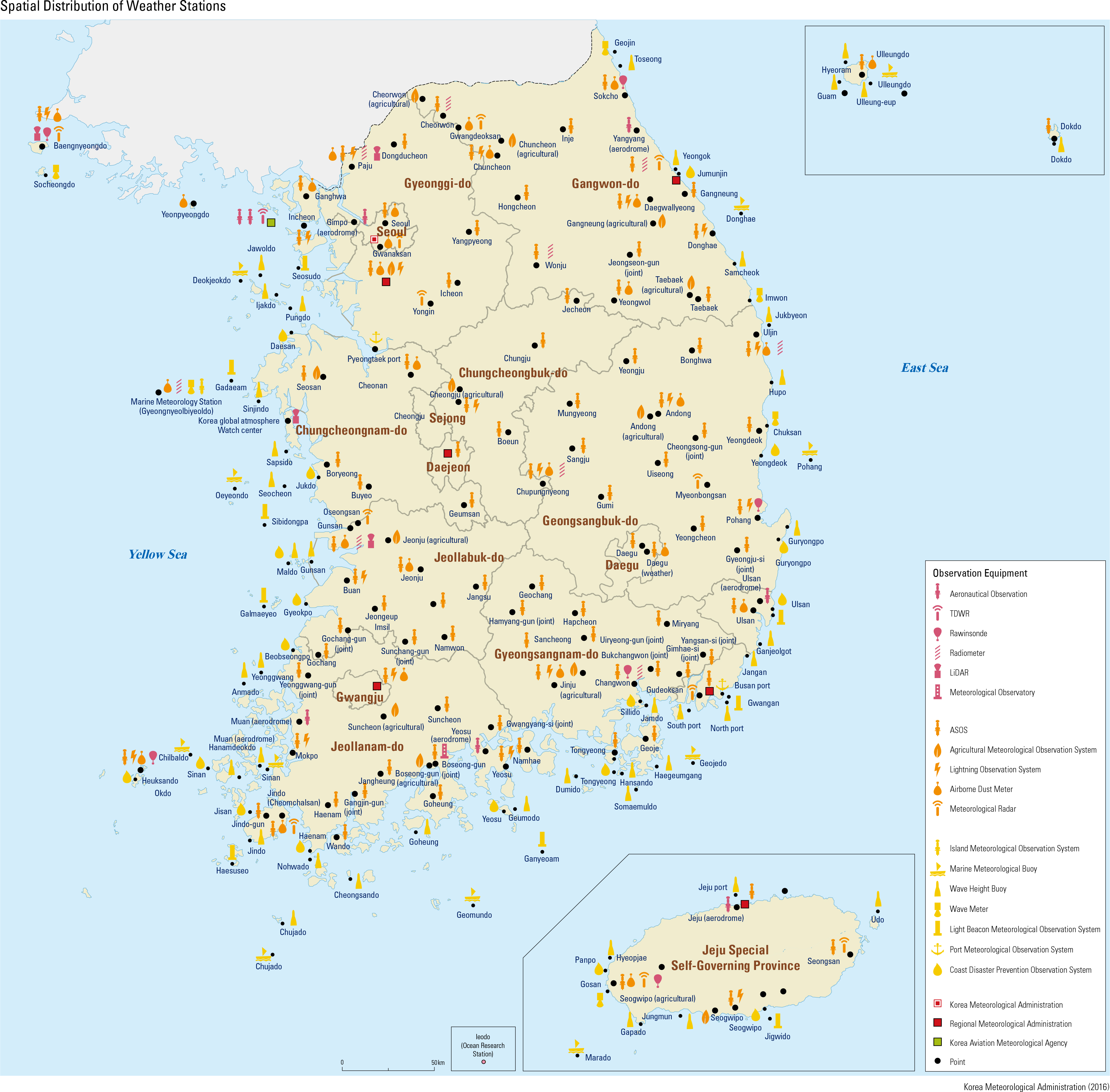
Korea has made rapid advancements in mete- orology in the 2000s. In 2010, Korea became the seventh country in the world to operate an indepen- dent weather satellite with the completion of the National Meteorological Super Computer Center. In the following year, a weather ship began con- ducting comprehensive ocean observations. Currently, the Korea Meteorological Adminis- tration (KMA) is in charge of the weather service. The KMA consists of its headquarter, the National Institute of Meteorological Sciences (NIMS), 6 regional offices, 3 branch offices, 7 weather ob- servatories, the National Meteorological Satellite Center (NMSC), the Weather Radar Center, and the Aviation Meteorological Of ce (AMO). Meteorological observation requires not only traditional equipment and methodology, but also state-of-the-art observation equipment such as the Automatic Weather Station (AWS), radar, satellite, and weather ship. In Korea, there are a total of 590 AWSs where weather conditions are automatically monitored every minute. The observation density of weather stations in Korea is high because they are spaced on average about 13 km apart, which is closer than those in Japan (about 15 km) and the United States (about 20 km). There are a total of 7 upper-air observation sta- tions that measure vertical atmospheric conditions at altitudes of 0 – 35 km using rawinsonde. Raw- insonde observations are conducted twice a day under regular weather conditions, and four times a day under severe weather conditions. In addition, wind pro lers are installed at 9 stations to observe wind direction and wind speed at 0 - 5 km above land surface. Radiometers are installed to measure air temperature and humidity every 10 minutes at 0 - 10 km above land surface. The observations cover the entire Earth, East Asia, and the surroundings of the Korean Penin- sula at 3-hour intervals, 15-minute intervals, and 8-minute intervals, respectively, via Chollian, Korea’s rst geostationary meteorological satellite launched in 2010. The data collected by the satel- lite are not only signi cant for detecting typhoons, fog, Asian dust, and forest fires, but also widely applied in various elds such as hydrological and environmental management. In addition, the Me- teorological Satellite Data Analysis System is used for the process of reception, processing, analysis, and utilization of the data collected from multiple geostationary and polar-orbiting weather satellites. Because of its topographic characteristic, a pen- insula surrounded by water on three sides, Korea carries out marine weather observations at major points along the coast by placing marine weather buoys, wave height buoys, drift buoys, the Coast- al Disaster Prevention Observation System, Port Weather Observation System, light beacon weather observation system, and wave meters. A total of 12 weather radars, including one for experimental purposes, are operated to understand precipitation extent and intensity. The radar images are synthesized every 10 minutes to identify pre- cipitation patterns.
page_2 |