English II
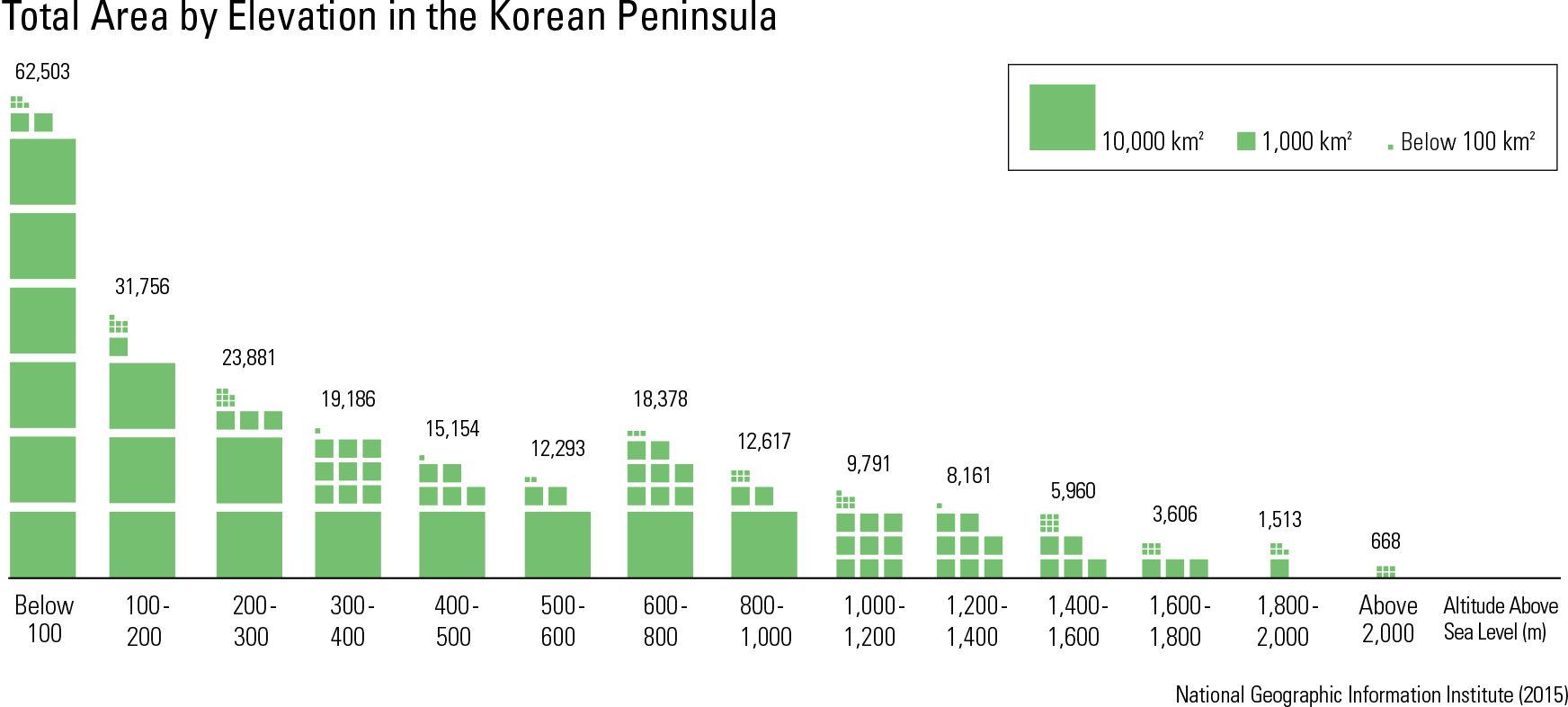
The Korean Peninsula is bordered by water on three sides. In contrast to its smooth eastern coastline, its southern and western coastlines are extremely complex. The peninsula has relatively long coastlines for its size. According to a 2014 survey, the total coastline of the mainland is 7,753 km, while the coastlines of Korea’s as- sociated islands constitute 7,210 km. Arti cial coastlines resulting from coastal development and port construction have reached 5,086 km. One of the most signi cant geographic charac- teristics of the Korean Peninsula is its prominent NNW-SSE oriented mountain ranges: Nangrim- sanmaek (Nangrim Mountain Range) and Tae- baeksanmaek (Taebaek Mountain Range). These mountain ranges resulted from the formation of a back-arc basin on the edge of the Asian continent, a process that also produced the Hamgyeong- sanmaek (Hamgyeong Mountain Range) and the Sikhote-Aline Mountain Range in Russia. The Ul- leung Basin, located in the East Sea, was formed due to the Taebaeksanmaek uplift. The average elevation of the Korean Peninsula is approximately 448 m above sea level, which is notably lower than that of East Asia (910 m). The mean slope of the peninsula is 5.7 ̊, which is two degrees steeper than the mean of East Asia (3.9 ̊). Overall, while the peninsula has a lower elevation than that of East Asia, it has a signi cant spread of steep mountainous regions. 77.4% of South Korea is covered in mountainous areas that are less than 400 m in elevation. High mountains are asymmetrically located to the east and north of the peninsula, following the ranges of Taebaeksanmaek, Nangrimsanmaek, and Hamgyeongsanmaek. The last two rang- es contain the highest elevations; Dojeongsan, Kwanmobong, Duryusan of Hamgyeongsanmaek and Heesaekbong, Maengbusan, Nangrimsan of Nangrimsanmaek are all peaks that stand over 2000 m. On the other hand, Taebaeksanmaek – which runs 500 km from Youngheung Bay in North Korea to Busan in South Korea – has a much lower elevation. Major mountains such as Geumgangsan, Seoraksan, and Odaesan are about 1,500 – 1,700 m high. Toward the southern part of the peninsula, granite is distributed in circular or girdle-shaped areas between metamorphic rocks. Well-devel- oped erosional basins form on the granite and are encircled by high peaks of metamorphic rocks. These erosional basins characteristically include transit zones with gentle slopes of 1 – 10 ̊ that are located between steep mountains and at plains. Because Taebaeksanmaek and Hamgyeonsan- maek are located on the eastern region of the Korean Peninsula, most large rivers flow south- west from the major watersheds of the mountain ranges. Meanwhile, streams that lead into the East Sea on the steeper eastern slopes of the ranges are shorter. This disparity is a central characteristic of rivers on the Korean Peninsula. Due to the pen- insula’s relatively high average slope and signi - cant seasonal difference in precipitation, Korean rivers are also characterized by a high coef cient of river regime. Furthermore, most rivers display wide valleys and gentle gradients.
page_2 |