English II
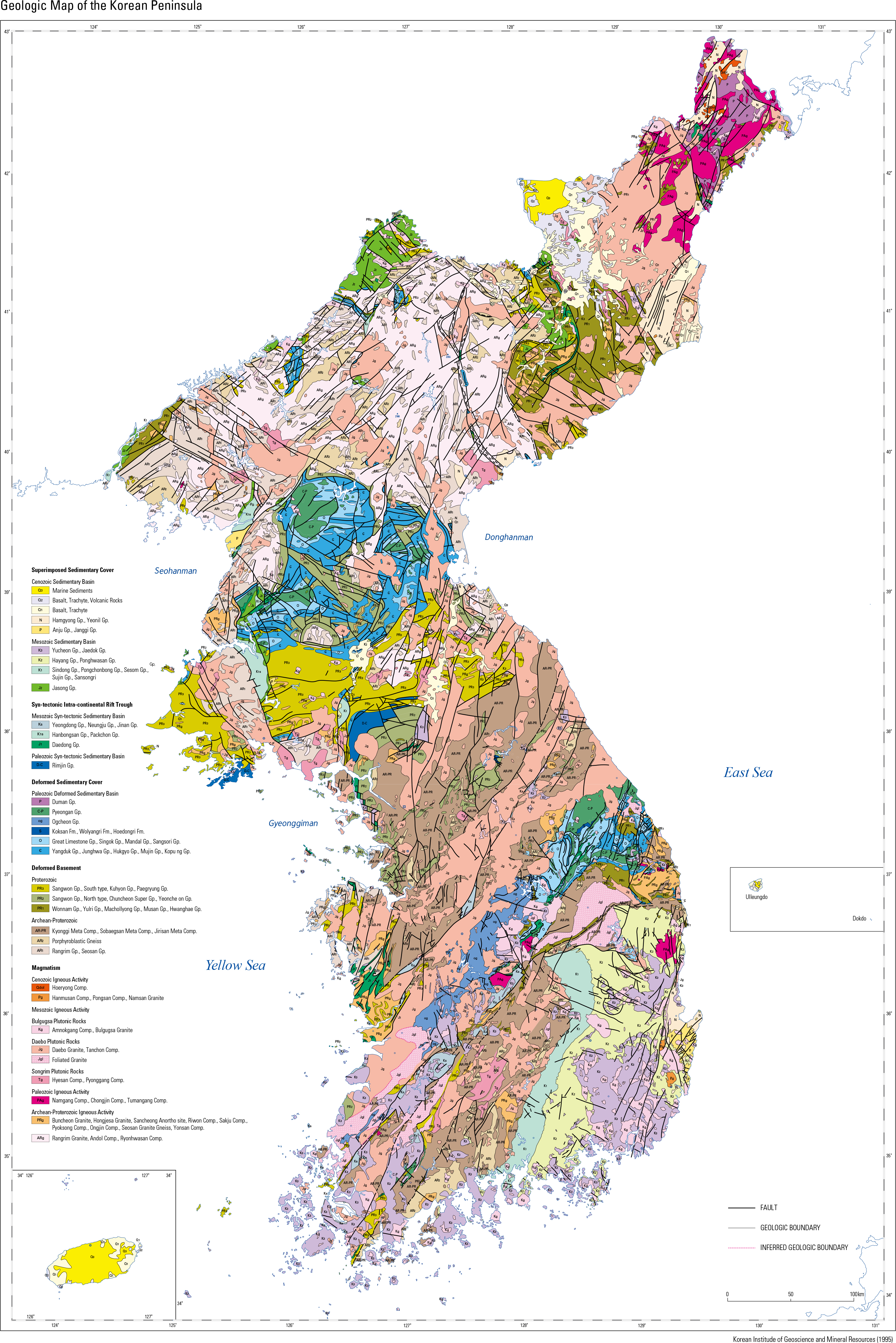
The Korean Peninsula consists of various rocks formed in the space between a depth of 60 km and the surface of the Earth over the wide span of time from the Archean to Cenozoic. These rocks help geologists to interpret the tectonic evolution of the Korean Peninsula and Northeast Asia from 2.5 Ga (Ga: billion years ago) to the present. In particular, the geology of the Korean Peninsula is very important for interpreting the tectonic relationship between Korea, China, and Japan be- cause of its geographical location between China and Japan. On the Korean Peninsula, the oldest rocks are Neoarchean meta-igneous rocks with an age of ca. 2.5 Ga. Older rocks were recycled through the rock cycle into Paleoproterozoic metasedimentary and igneous rocks with an age of ca. 1.9 – 1.8 Ga. The Paleoproterozoic rocks make up the base- ment of the Korean Peninsula and are classi ed, from north to south, into the Nangrim, Gyeonggi, and Yeongnam Massifs. The Paleozoic Imjingang belt, which formed westward along the Imjingang to the Chugaryeong graben, divides the Nangrim and Gyeonggi Massifs. The Nangrim Massif runs through Hamgyeong-do, Pyeongan-do, northern Gangwon-do, and Hwanghae-do. The Gyeonggi Massif runs through Gyeonggi-do, Chungcheong-do, and southern Gangwon-do. The Gyeonggi and Yeongnam Massifs are divided by the Neoproterozoic-Paleozoic Ogcheon belt, which extends northeastward from Jeollanam-do (including Hwasun) to Gangwon-do. The Yeo- ngnam Massif runs through Jeolla-do and Gyeo- ngsang-do. The Ogcheon belt contains the north- eastern Taebaeksan Basin and the southwestern Ogcheon metamorphic belt. The Paleoproterozoic metamorphic and igneous rocks, which formed at a depth of about 35 km, are now exposed at the surface due to tectonic uplift and erosion. Neoproterozoic rocks are widely distributed in the Sangwon System, which occupies the south- ern part of the Nangrim Massif, between Haeju and Wonsan and consists mostly sedimentary rocks. Neoproterozoic rocks were recently dis- covered from the area adjacent to the Imjingang belt, the Hongseong area in Chungcheongnam-do, and the northeastern Ogcheon metamorphic belt. Paleozoic sediments are widely distributed in the Pyeongnam Basin in Pyeongan-do, the Tae- baeksan Basin in Gangwon-do, and the Ogcheon metamorphic belt. They are also found in the Im- jingang belt, and the northeastern Hamgyeong-do. The Pyeongan and Taebaeksan Basins consist of the Chosun and Pyeongan Supergroups; the Chosun Supergroup was deposited between the Cambrian and Early Silurian and the Pyeongan Supergroup was deposited unconformably on the Chosun Supergroup between the Middle Carbon- iferous and Permian. The Chosun Supergroup consists of marine sediments, including limestone that played an important role in the industrializa- tion of Korea by supplying the raw material for cement. Most coal mines in Korea locate in the Pyeongan Supergroup. Devonian sediments are found in the Imjingang belt, but the sedimentation ages of Paleozoic rocks in the Ogcheon metamor- phic belt are not clear. The Duman Supergroup in northeastern Hamgyeong-do consists of Carbonif- erous-Permian sediments. Late Paleozoic igneous rocks are found in northeastern Hamgyeong-do and are also reported in the Hongseong and Mungyeong areas. On the Korean Peninsula, Triassic and Jurassic sediments occur only locally in limited areas. However cretaceous sediments of the Gyeongsang Supergroup are widely distributed in Jeolla-do and Gyeongsang-do. The Gyeongsang Super- group consists of non-marine sediments deposited in the lake, which provided a good habitat for dinosaurs. Consequently, many dinosaurs lived on the Korean Peninsula, leaving abundant fossils in the Cretaceous sedimentary layers, including footprints and eggs and bone fossils. From the Late Permian to Cretaceous there was a subduc- tion zone around the Korean Peninsula and sub- duction-related igneous rocks regionally intruded the Korean Peninsula. In particular, there was an extensive igneous intrusion during the Jurassic, forming the Daebo Granite, which comprises the main foundation of the Korean Peninsula along with Paleoproterozoic rocks. A recent study shows that part of Jurassic gran- ites in the northern Gyeonggi Massif are in fact Triassic granites related to continental collision within the Korean Peninsula. Further evidence of Triassic continental collision is provided by the Triassic eclogite found in the area of Hongseong. On the Korean Peninsula, there are minor distri- bution of small scale Triassic and Jurassic sedi- ments, and the Jurassic granites that formed at a depth of around 15 km are directly covered with Cretaceous volcanic and sediment rocks. These facts indicate the uplift of the Korean Peninsula before the Cretaceous. During the Cenozoic, the East Sea was formed, separating Japan from Korea and uplifting the eastern part of the Korean Peninsula. Due to the uplift, the eastern part of the Korean Peninsula was elevated higher than the western part, result- ing in westward tilting. The Baekdusan, Ulleung- do, Dokdo, Jejudo volacanoes and the Chug- aryeong graben also formed during the Cenozoic with the Cenozoic sedimentary in Hamgyeong-do and Pohang. The Korean Peninsula is relatively safe from earthquakes compared to Japan, which is located on the plate margin, but it is not completely safe. Although not abundant in most cases, many kinds of mineral resources have been found on the Korean Peninsula. Recently Korean researchers have expanded the scope of research to overseas geology. As a result, mining areas for manganese nodules in the Paci c Ocean (1994), exploration rights for hydrothermal deposits in Tonga and Fiji (2008, 2011), and mining areas for hydrothermal deposits in the Indian Ocean (2012) were acquired and the geologic map of Suai in East Timor was made. Since 1987, research on the polar regions has also been carried out.
page_2 |