English II
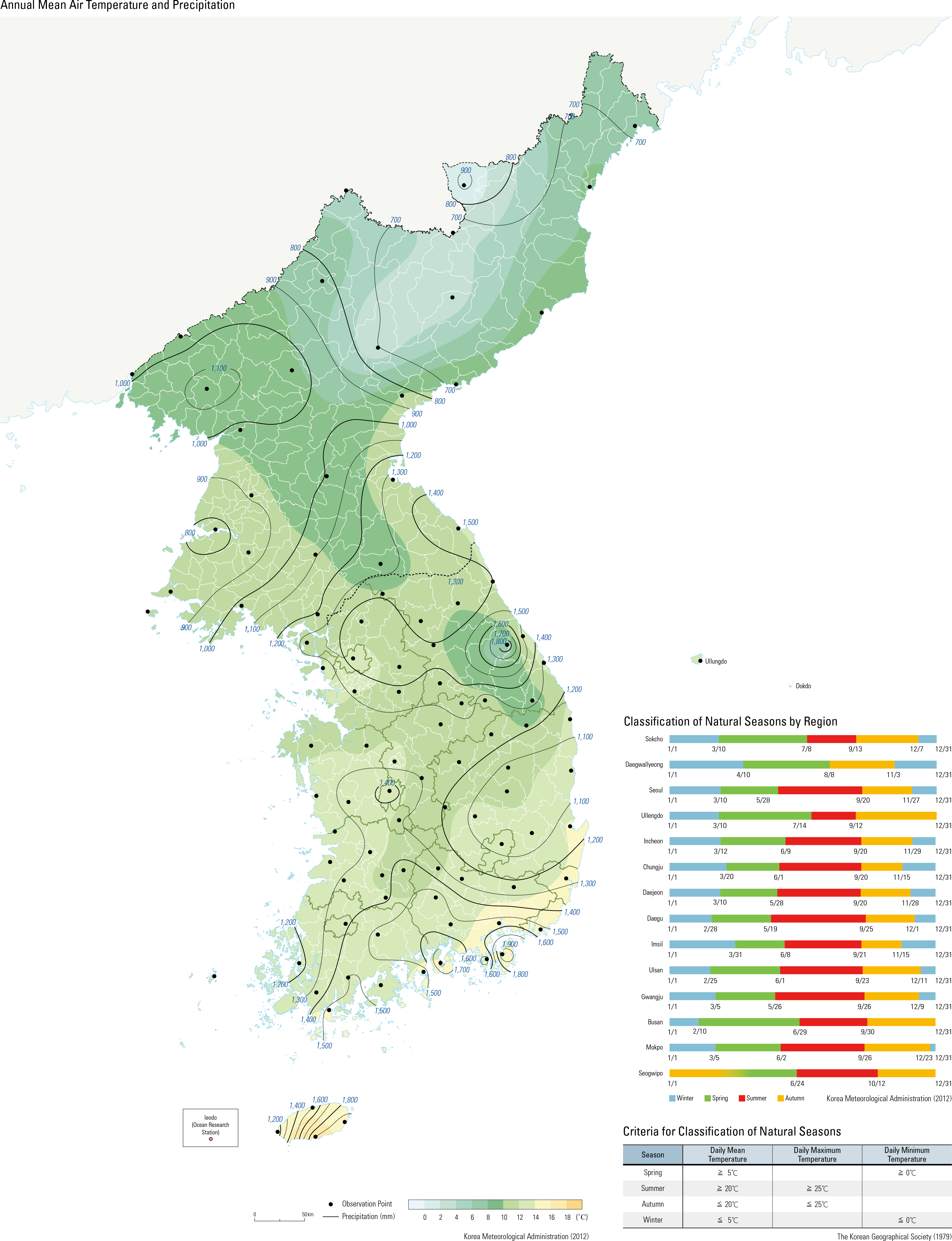
The spatial distribution of climate in Korea is determined by key climate factors such as lati- tude, elevation, geographical location, land/sea heating properties, ocean current, the East Asian Monsoon system, and air mass. During the sum- mer, it is hot and humid, but during the winter, it is cold and dry in response to the East Asian Monsoon. The difference in temperature between the northern area and the southern area is clear. This is because the amount of solar energy received and difference in length of daylight vary with lat- itude, for the north-south stretched characteristic of the Korean Peninsula. The difference in annual mean air temperature between Seogwipo (16.6 ̊C), located at the southernmost tip of South Korea (33 ̊ 14' N), and Cheorwon (10.2 ̊C), located at the northernmost tip (38 ̊ 08' N) of South Korea, demonstrates a wide variation in air temperature with latitude. The climate features vary depending on el- evation. The annual mean air temperature at Daegwallyeong (773 m), the highest located ob- servation station in South Korea, is 6.6 ̊C, which is 3.7 ̊C lower than that at Hongcheon (10.3 ̊C), which is at 141 m and located at a similar latitude. The difference in the mean air temperature is also found in the southern area between Imsil (248 m) and Jeongeup (45 m), with 11.2 ̊C and 13.1 ̊C, respectively.The geographical location also makes a differ- ence in climate. The Taebaeksanmaek (Taebaek Mountain Ranges) acts as a barrier to the flow of air and brings a marked difference in climate between the Yeongseo area (windward side) and Yeongdong area (leeward side). When a cold northwesterly wind dominates over the Korean Peninsula during the winter, the air temperature at Chuncheon, located in the Yeongseo area, is low. Whereas in Sokcho, located in the Yeong- dong area, the temperature increases. The average temperature for the warmest month, August, in Chuncheon (24.6 ̊C) is higher than that in Sokcho (23.7 ̊C), while the average temperature for the coldest month, January, in Chuncheon (-4.6 ̊C) is much lower than that in Sokcho (-0.3 ̊C). How- ever, as a northeasterly wind blows over the Tae- baeksanmaek, Chuncheon becomes warmer while Sokcho becomes colder. In addition, when the northeasterly wind crosses the East Sea with its warm current ows and is forced to rise over the mountain barrier, heavy snow occasionally falls in Yeongdong area as a result. Korea is largely characterized by a continental climate due to the effects of the Eurasian conti- nent. However, the climate of the coastal areas, which is mostly governed by the ocean, differs from that of the inland areas. The annual mean temperature range for Daejeon is only 0.3 ̊C greater than that of Boryeong, which is adjacent to the coast. The average temperature during the summer (months of June, July, and August) in Daejeon is approximately 1.3 ̊C higher than that in Boryeong. Ocean currents can also affect the climate of Korea: the East Korean Warm Current and North Korean Cold Current in the East Sea, and the Yellow Sea Warm Current in the Yellow Sea. The East Korean Warm Current, diverging from the Tsushima Current at the eastern end of the Korea Strait, ows along the eastern coast of Korea and provides warm ocean water up to the latitude of 37 ̊ – 38 ̊ N. Part of the current flows north up to the coast of Goseong, Gangwon-do, and affects the climate of the surrounding area. The North Korean Cold Current, a part of the Liman Current flowing from the Sea of Okhotsk, flows southward along the coast of Hamgyeong-do and reaches down to the southern region of Gang- won-do during the winter. The Yellow Sea Warm Current, a tributary of the Tsushima Current, flows from the western waters of Jejudo to the southern part of the Yellow Sea and occasionally exerts in uence on the climate of the west coast. The northward movement of the Yellow Sea Warm Current weakens during the winter, while the in ow becomes stronger during the summer. The Asian monsoon system over East Asia (in- cluding Korea, China, and Japan) is formed due to the land-sea distribution and the associated difference in heating properties. While cold, dry wind blows into the Korean Peninsula in the win- ter due to the continental effect, hot and humid wind blows into Korea during the summer due to the effect of the North Paci c. The climate of Korea is also under the influence of various air masses such as the Siberian, the North Paci c, the Okhotsk Sea, and equatorial air mass. The classification of natural seasons based on the criteria of daily mean air temperature, daily maximum air temperature, and daily minimum air temperature results in regional differences in be- ginning date and number of days for each season. Spring comes the earliest in Busan (February 10), apart from Seogwipo, while it comes the latest in Daegwallyeong (April 10). Besides Daegwal- lyeong (August 8) and Sokcho (July 8), summer mostly begins between late May and early June, lasting about 70 – 120 days. Autumn starts around the middle of September, with shorter duration (60 – 80 days) than spring and summer. Winter gen- erally commences around late November, lasting about 100 – 130 days.
page_2 |