English I 2019
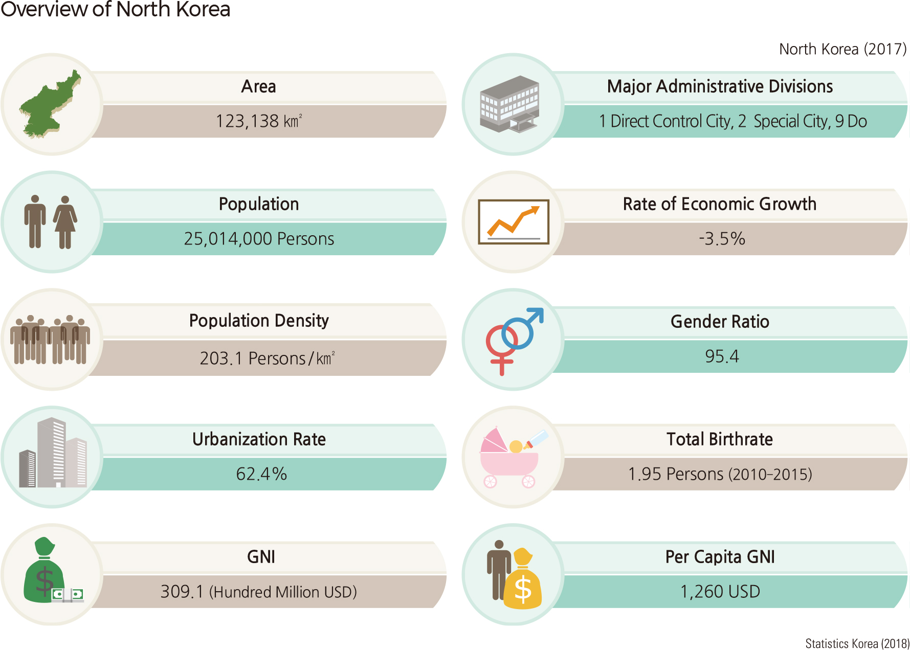
North Korea lies north of the demarcation line set by the Korean Armistice Agreement in July 1953. Its total area is 123,138 km², accounting for approximately 55% of the entire Korean Peninsula, which is 223,516 km². As of 2017, the population of North Korea was about 25,014,000, and its population density was 203.1 persons / km². This is close to 40% of that of South Korea, whose population density is 512.6 persons / km². North Korea faces the East Sea to the east and the Yellow Sea to the west and shares a border with the northeastern part of China along the Amnokgang River (Yalu River) and Dumangang River (Tumen River), and with Russia’s Siberia along the Dumangang River. The boundary with China is 1,353.2 km long and features bridges such as the Amnokgang Bridge, which enables road and railway traffic to flow between Sinuiju in North Korea and Dandong in China. North Korea shares a border with Russia that is 16.2 km long and is connected by a railroad bridge between North Korea’s Dumangang Station in Naseon (Rason) and the Khasan Station just across the border in Russia. To the south, North Korea’s border with South Korea consists of the Military Demarcation Line, lying along Gaeseong (Kaesong)-si and Jangpung (Changpung)-gun in Hwanghaebuk-do, Cheorwon-gun, Pyeonggang-gun, Kimhwa-gun, Changdo-gun, Guemgang (Kumgang)-gun, and Goseong-gun in Gangwon-do and South Korea’s Gyeonggi-do and Gangwon-do.
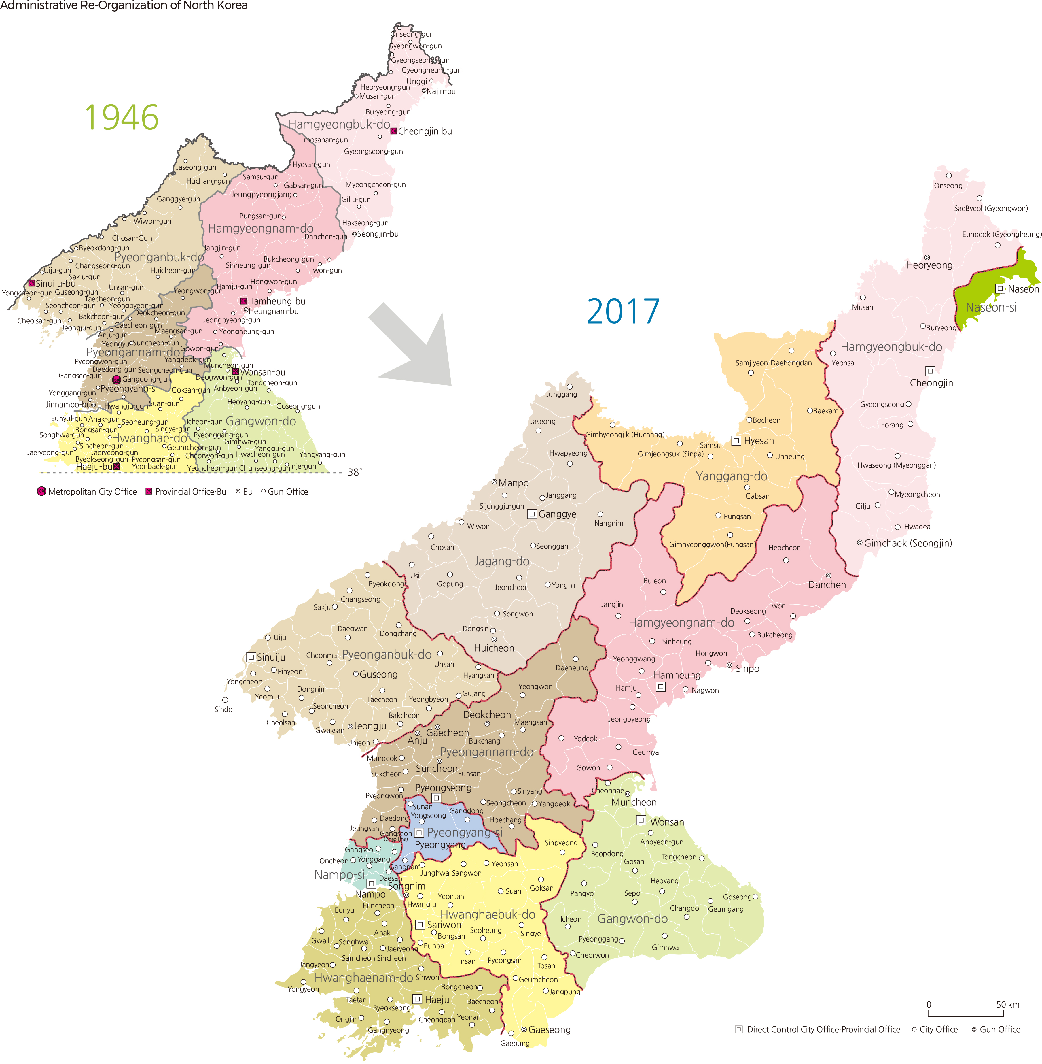
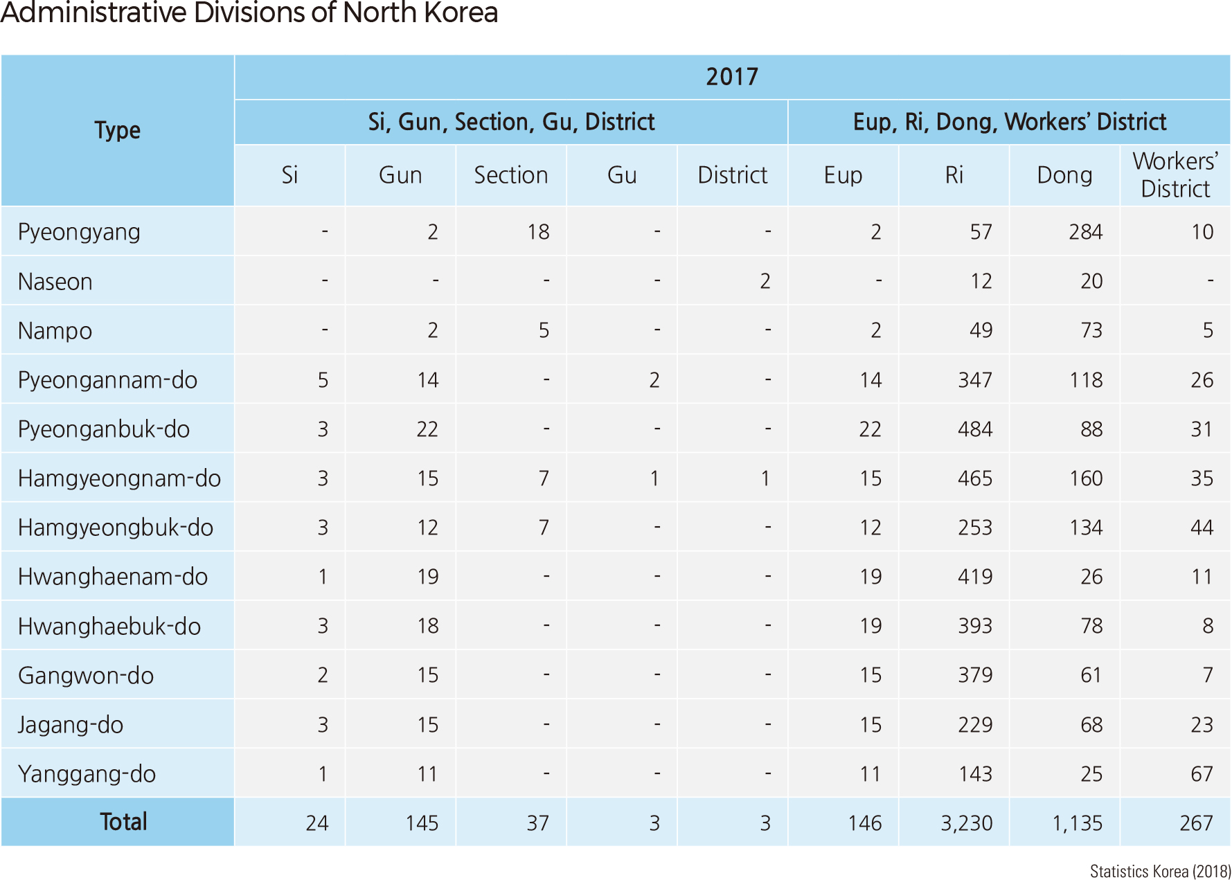
In 1945, when Korea was liberated from Japan, the administrative district of the northern region was comprised of six dos, nine sis, 89 guns, and 810 eups and myeons. However, administrative and district reform was carried out in December 1952, changing from a four-stage administrative system (1. do and special city; 2. si / gun; 3. eup / myeon; and 4. ri / dong) to a three-stage administrative system (1. province and direct-controlled city; 2. si / guyeok (section) / gun / gu / Jachigu (district); and 3. eup / ri / dong / workers’ district). Subsequently, there were several more administrative district reforms. What is notable is the promotion of the Special Cities of Naseon (Rason) and Nampo (Nampho) for economic purposes. As of 2017, North Korea consisted of one direct-controlled city of Pyeongyang (Pyongyang), two special cities (Naseon, Nampo), and nine provinces.
One of North Korea’s prominent geographical features is the Nangrimsanmaek Mountain Range, which is part of the Baekdudaegan (traditional way of representing backbone mountain ranges of the Korean Peninsula), and which runs from north to south. The following ranges are also part of Baekdudaegan: the Gangnamsanmaek Mountain Range, Jeoguryeongsanmaek Mountain Range, and Myohyangsanmaek Mountain Range located to the west, and the Hamgyeongsanmaek Mountain Range and Bujeollyeongsanmaek Mountain Range located to the east in Hamgyeongbuk-do and Hamgyeongnam-do. The northern and eastern parts of North Korea are mostly dominated by mountains and uplands, whereas the southern and western parts generally consist of plains and lowlands. Due to this topography, the rivers that run toward the Yellow Sea, including the Amnokgang River, Daedonggang River, Cheongcheongang River, and Yeseonggang River, tend to wind through the mountains before meandering on gentle slopes. In contrast, rivers that move toward the East Sea, such as the Dumangang River and Namdaecheon River, are straighter and much shorter in length than those of west-bound rivers. Consequently, North Korea’s major plains, which include the Pyeongyangpyeongya, Jaeryeongpyeongya, and Yeonbaekpyeongya, are located on alluvial deposits supplied by the larger rivers that run toward the Yellow Sea.
Much of the bedrock strata in North Korea were formed during the period between the pre-Cambrian and Cenozoic Eras, providing the country with a wide range of mineral resources. North Korea is one of the top ten countries in the world owning the largest reserves of magnesite, tungsten, molybdenum, graphite, barite, gold, mica, and fluorspar. There are 40 kinds of natural mineral resources that have economic value.
North Korea is in a temperate climate region and has a continental climate. Its winters are frigid as a result of northwestern winds that blow from Siberia, and the summers are hot and humid due to the southeastern monsoon winds that bring moist air from the Pacific Ocean. The average annual rainfall is between 600–1,500 mm, and 53–63% of all precipitation occurs from June to September. The overall rainfall is less than that of South Korea and varies widely depending on the region.
In the past, North Korea had an abundance of natural resources with ecological value. However, its forests have been consistently damaged due to programs such as “Nationwide Fortification,” one of the four military campaigns that began in the 1960s; “Terraced Field Farming,” one of the five nature reformation campaigns that began in the 1970s; and the project of “New Field Finding,” which began in the 1980s. Particularly in the 1990s, forests were devastated as financial difficulties forced people to find food and fuel in the mountains. In 2007, South Korea and North Korea agreed to “continuing cooperative projects in various areas such as agriculture, health, and medical services and environmental protection” in the October 4 Summit Declaration and discussed “proceed[ing] with the construction and utilization of a tree sapling nursery, reforestation and prevention of blight and harmful insects starting in 2008.” However in 2008, the South Korean government’s enforcement of the May 24 measure in 2010 discontinued not just inter-governmental forestry cooperation but also reforestation support from civil groups in South Korea. After both Koreas held the inter-Korean summit on April 27, 2018, the South Korean government selected forestry cooperation as a top priority task to implement “The Panmunjom Declaration for Peace, Prosperity and Unification of the Korean Peninsula.” As a result, the South and the North held inter-Korean forestry cooperation talks on July 4, 2018, to carry out the Panmunjeom Declaration, and inter-Korean forestry cooperation is now being promoted. |