English I 2019
This map is a copy of a manuscript world map made by Kwon Keun, Kim Sa-hyung, Lee Mu, and Lee Hoe in 1402 (the 2nd year of King Taejong). With China at the center of the map, it depicts the general form of the Old World, including Africa and Europe in the west with Joseon and Japan in the east. The western part of Arabia is also drawn on the map as it was known to Joseon cartographers thanks to the diffusion of Islamic cartography imported through Mongol influence during China’s Yuan Dynasty. The map shows that Joseon cartographers were aware of and interested in different parts of the world, and is based on the China-centric world view. According to the preface at the bottom, the map was constructed from sources based on two Chinese maps (Shengjiao guangbei tu and Hunyi jiangli tu), a map of Joseon, and a map of Japan. The map is recognized as one of the best world maps among those produced in the early 15th century and in particular, as the first world map that depicts the African continent as a whole.
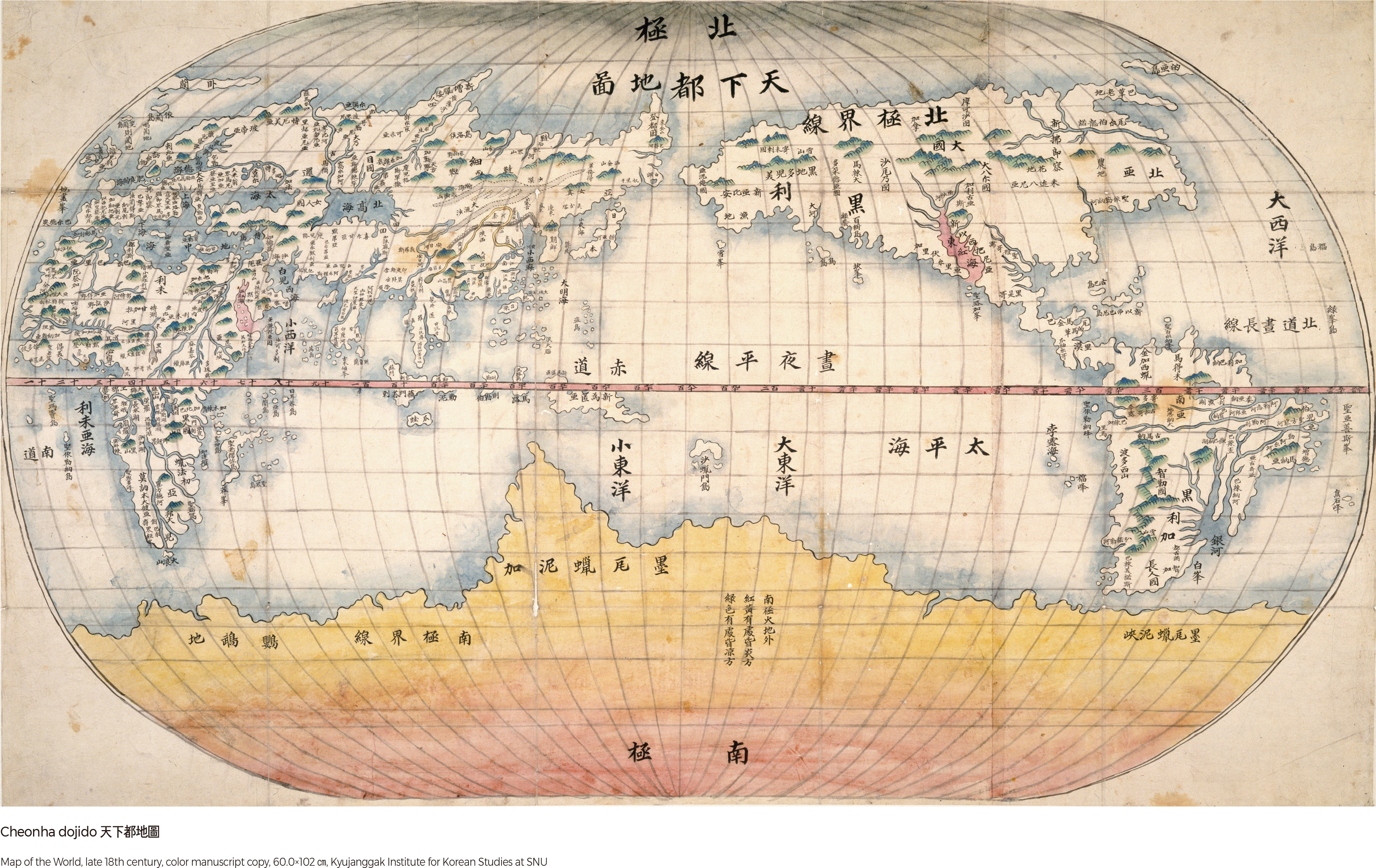
Cheonha dojido
The Cheonha dojido is a western-style world map drawn in Joseon based on Wanguo quantu (Complete Map of All the Countries) in Zhifang wai ji, a book-length geographical description of the entire world authored by Giulio Aleni, a Christian missionary. Like the Kunyu wanguo quantu (A Map of the Myriad Countries of the World) made by Matteo Ricci, a Jesuit priest, this map placed China and East Asia at the center of the projection with the central meridian placed in the middle of the Pacific Ocean. It was an intentional arrangement promoting Sino-centrism. Southern continents were marked as mystery lands, reflecting that the southern hemisphere, including Oceania, was not yet known to the cartographer. The Cheonha dojido clearly labeled the “Small East Sea” and the “Small West Sea,” referring to the East Sea and the Yellow Sea, which did not appear on Aleni’s map, Wanguo quantu.
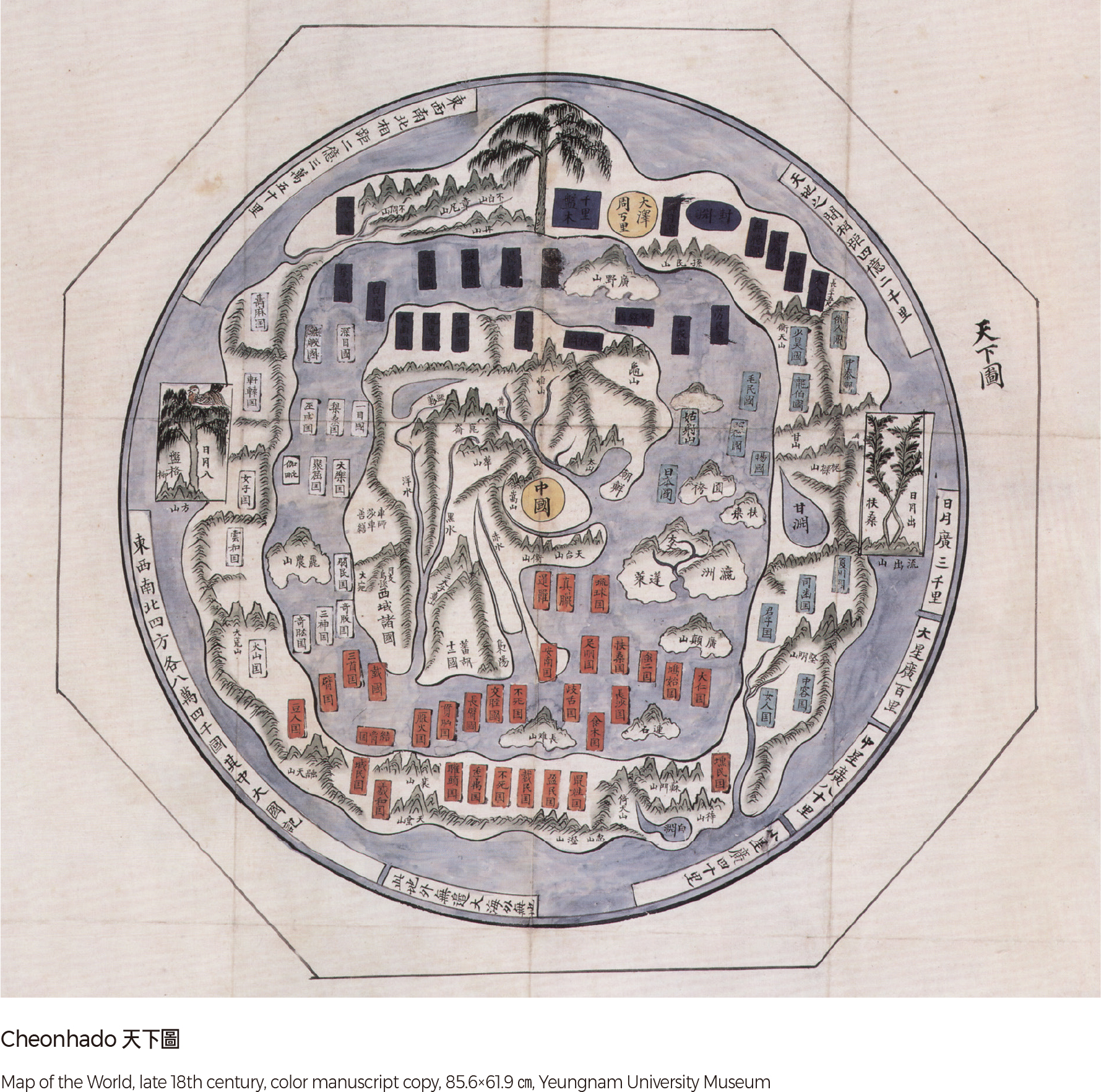
Cheonhado
The Cheonhado is a circular world map highly popular among literati-scholars of the late Joseon Dynasty. The map was drawn within a circle. The structure of the map consists of an inner continent surrounded by an inner sea, an outer continent, and an outer sea. The inner continent contains actual countries like China, Joseon, Annam, and India. The inner sea includes both real island countries like Japan and the Ryukyu Kingdom, as well as imaginary states like the Ilmok Kingdom, the Daein Kingdom, and the Samsu Kingdom that appeared in the Chinese Shanhaijing (Classic of Mountains and Seas). The outer continent is mostly filled with mythological kingdoms. This circular map is unique, reflecting the traditional ideas of ‟Tian Yuan Di Fang” (round heaven and square earth), Sino-centrism, and Taoism.
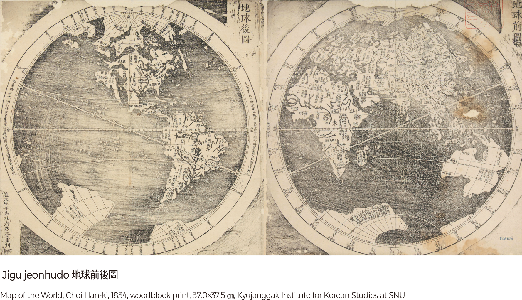
Jigu jeonhudo
The Jigu jeonhudo, made by Choi Han-ki in 1834, is a wood-block atlas of the hemispheres based on Zhang Tingfu’s world map. The bottom left of the Jigu jeonhudo is marked with the production date and the nom de plume (pseudonym) of the cartographer, Tae Yeon-jae, which was the Buddhist name of Choi Han-ki. This map is different from the Kunyu quantu (Map of the World), an earlier map of the eastern and western hemispheres made by Ferdinand Verbiest, a Western missionary. While the Kunyu quantu has gaps between the lines of longitude that widened toward the edges, the Jigu jeonhudo has even gaps between lines of longitude. Also, the 24 seasonal divisions were labeled, something which did not appear in other contemporary maps. The equator, ecliptic latitudes, and the tropics were highlighted. Unlike the Kunyu quantu, Oceania and Antarctica were drawn separately, implying that Choi Han-ki knew about the discovery of those regions. |