English I 2019
Korean territory was represented on old maps created in the pre-modern era. Although the boundaries of the territory on these maps are not as clear as on maps made in the modern era, these antique maps reflect various and unique aspects of historic Korean territory and serve as evidence for territorial claims made today. Collectively, they represent Korean land ownership and Korean territorial perceptions of land as they have been shaped over time. These territorial documents are found not only on maps of prefectures, military maps, and general maps of Korea, but also on world maps made by cartographers, both Korean and others from around the world.
Although mapmaking in Korea dates back to before the Three Kingdoms Period, only the maps made during the Joseon Dynasty now survive. The oldest existing Korean map today is the Honil gangni yeokdae gukdo jido (Map of Integrated Lands and Regions of Historical Countries and Capitals), which was made in 1402. This map is recognized as one of the best world maps among those in both Eastern and Western civilizations at the time. On the Gangnido, Joseon territory is bigger on the map than Africa, which reflects the Joseon Dynasty’s pride in itself as a civilized state akin to China. Korean territory is most precisely delineated in a series of maps entitled Joseon jeondo (Complete Maps of Joseon). In the 15th century, cartographic efforts at making world maps and general maps of Joseon were largely based on land surveys. Under the reign of King Sejong, the fourth king of the Joseon Dynasty, the distances between counties and prefectures were measured, and the latitudes of Baekdusan Mountain, Manisan Mountain, and Hallasan Mountain were determined, which prepared the future scientific foundation for the efforts of the Joseon Dynasty cartographers. Jeong Cheok completed a map of the two border regions (currently Hamgyeong Province and Pyeongan Province) in 1451 and made the Dongkuk jido (Map of Korea) with Yang Seong-ji in 1463 (the 9th year of King Sejo). The Joseon bangyeok jido (Map of the Korean Territory) is a great example of the Joseon jeondo series made in the 15th century. This map features the Korean Peninsula, Manchuria to the north of the Amnokgang River, and the Dumangang River. It represents the view of the national territory held by Korean elites and scholars like Yang Seong-ji, who believed Korean territory extended beyond the Peninsula to include Manchuria.
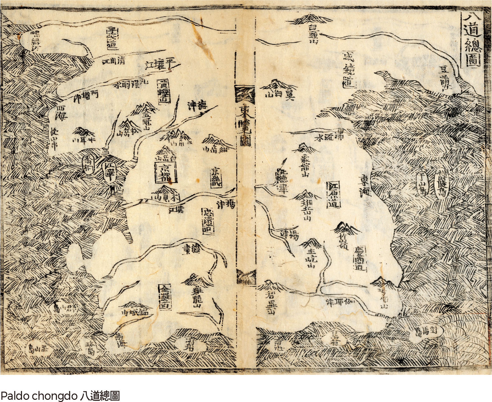
The Paldo chongdo (General Map of Eight Provinces) included in Sinjeung dongguk yeoji seungnam (Complete Conspectus of the Territory of the Eastern Country), which was made in 1530, is one of the most representative maps of Korean territory produced in the early Joseon Dynasty. This map takes the form of an appended chart to complement the geographical description, but its description of the land is rather crude. The purpose of the map is not to delineate the country’s territory in detail, but to express the establishment of royal authority and Confucian ideas for governance by means of commemorative rites of the national land. The map indicates noted mountains, large rivers, and seas that are included in ritual codes. It also features some islands in the East Sea and the Yellow Sea such as Ulleungdo, Usando (currently Dokdo), and Heuksando, which highlights the fact that they belonged to the Joseon Dynasty as long ago as the 16th century.
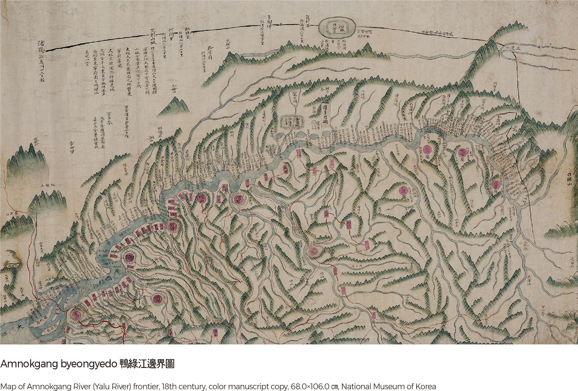
In the late Joseon Dynasty, after the two devastating wars with Japan and Manchuria, various types of maps were made with the specific intention of defining the boundaries of Joseon territory. The increased awareness of border regions, such as the northern part of the Peninsula and the coastal and insular areas, was reflected in these maps. Military maps like Yogye gwanbang jido (Map of the Yogye Borderland) and Seobuk pia yanggye malli illam jido (Comprehensive Map for Defense of the West and North Border) identified the borderlands near the Amnokgang River and the Dumangang River. Sea route maps were needed to defend the territorial boundaries and coast. These maps prove that the specified borderlands belonged to Joseon.
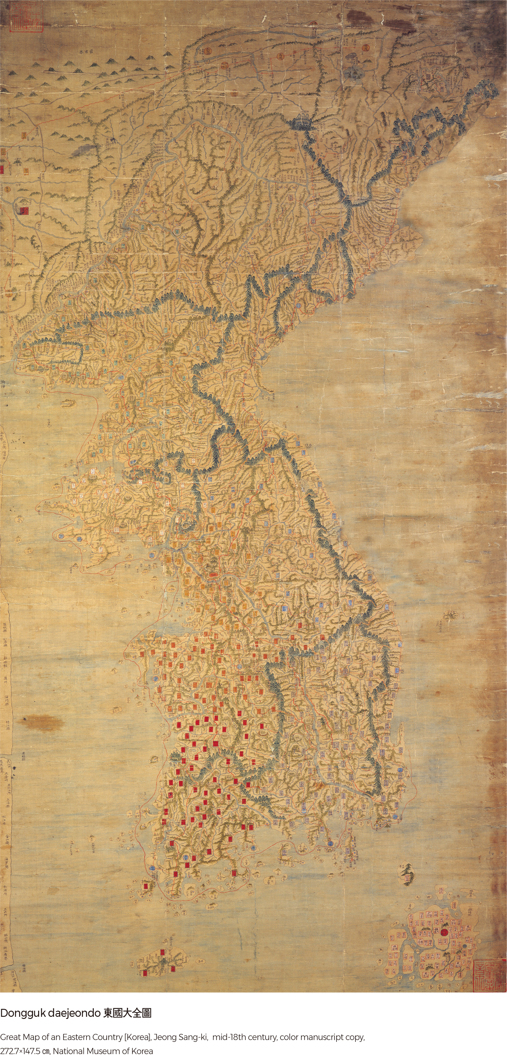
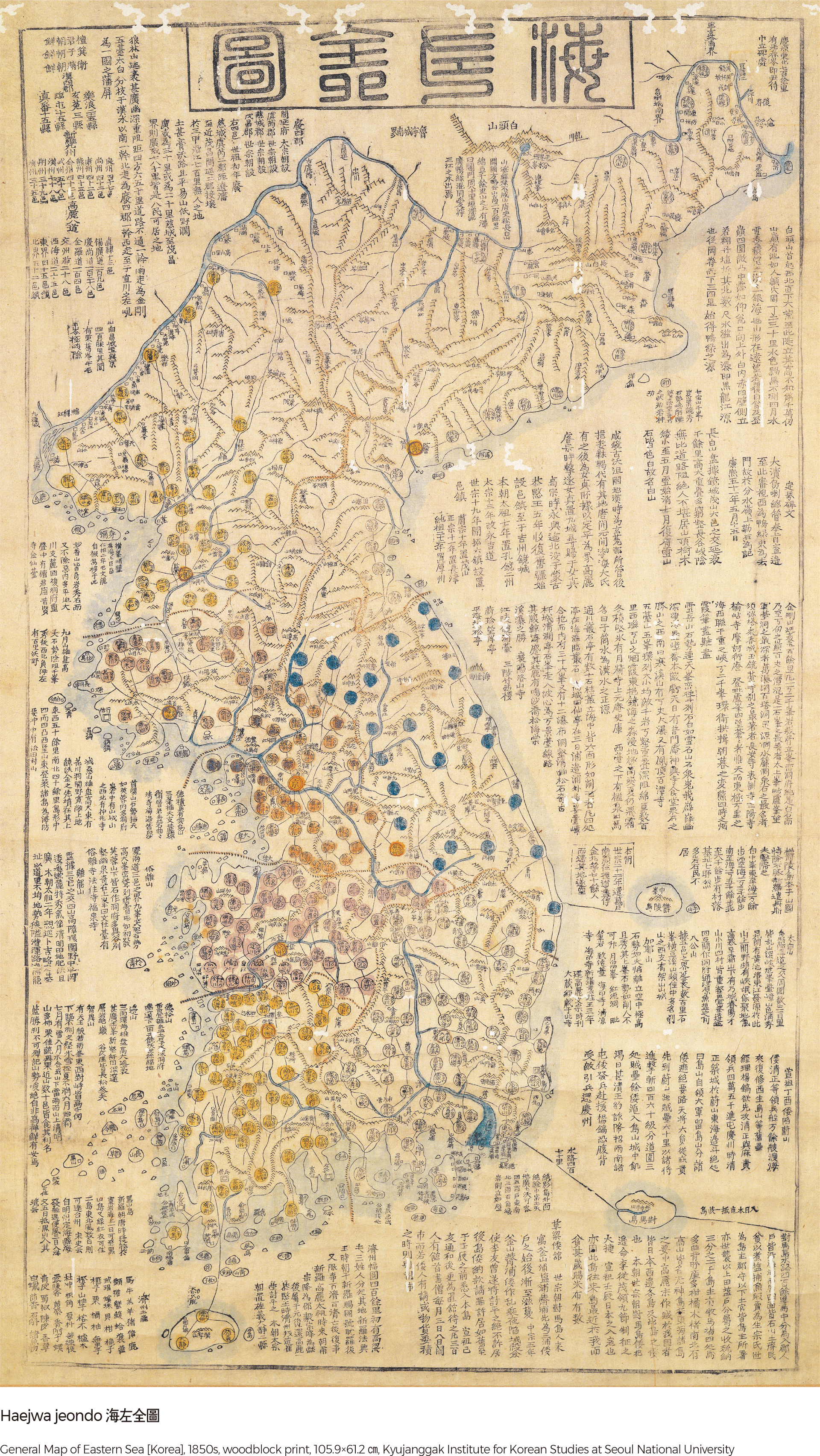
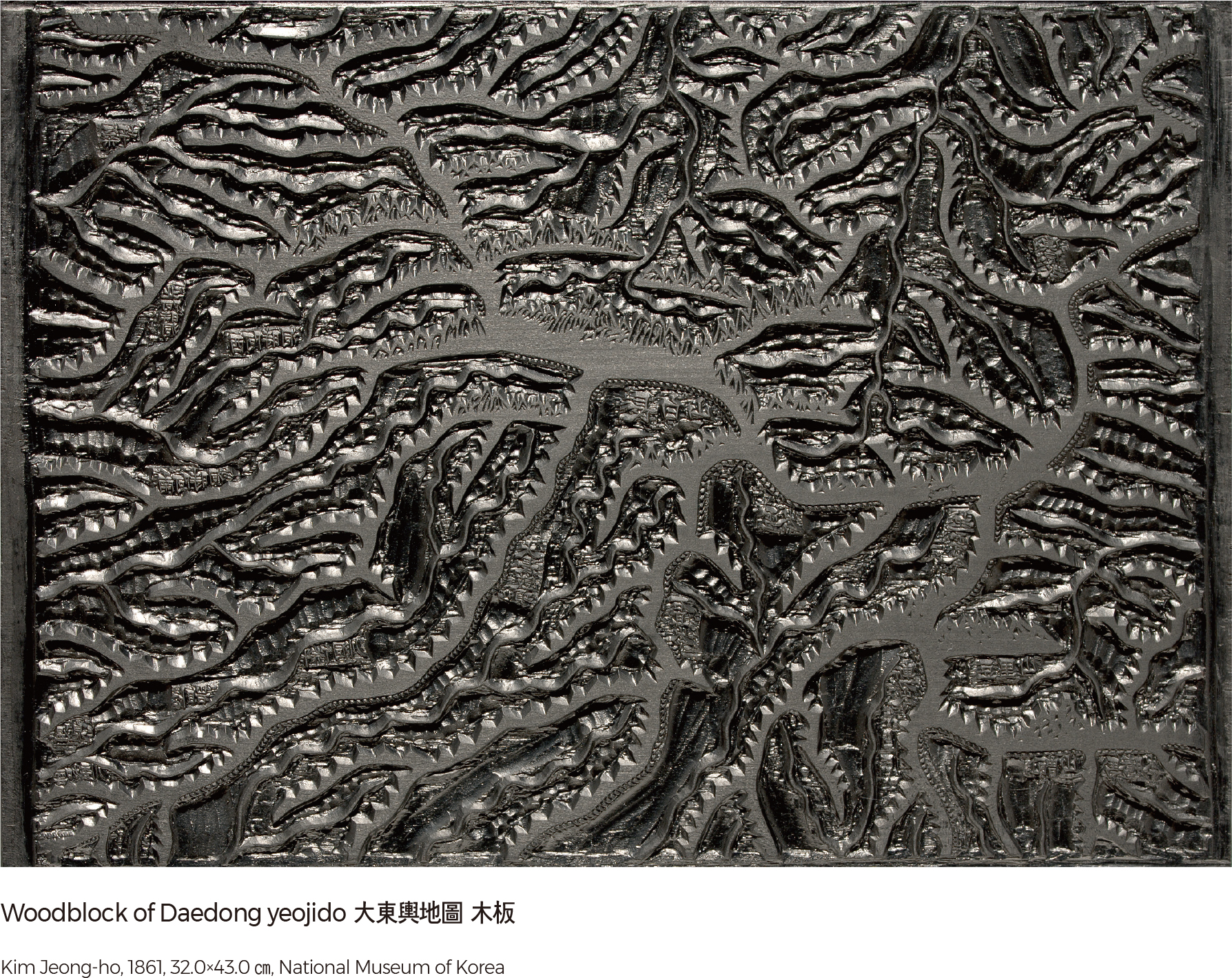
In the mid-18th century, the Dongkuk jido (Map of Korea), made by Jeong Sang-ki, was a watershed moment in late Joseon Dynasty mapmaking. Unlike the maps of the early Joseon Period, the scale of this map is large at 1:420,000. It contains the channels of the Amnokgang River and the Dumangang River and describes the coastlines as precisely as contemporary maps. The Dongkuk jido was hailed as the first map to truly describe Korean territory. It was widely copied and used by government offices and civilians, later becoming the basis for block-printed maps of Korea, such as the Haejwa jeondo (Complete Map of Haejwa). When the two volumes are unfolded side by side, the sections combine to form a comprehensive view. In 1861, Kim Jeong-ho completed the Daedong yeojido in wood-blocks, a splendid cartographic masterpiece of the Joseon Dynasty.
The territorial boundaries of the Joseon Dynasty were firmly established when Kim Jeong-ho made the Daedong yeojido (Territorial Map of the Great East).
Kim Jeong-ho compiled an atlas entitled the Cheonggudo (Map of Korea) in 1834 based on previously accumulated cartographic knowledge and accomplishments. The Cheonggudo is comprised of two books: Volume 1 includes odd-numbered sections and Volume 2 contains even-numbered sections.
Complementing the Cheonggudo, the Daedong yeojido was an innovation in terms of its form and content. The Cheonggudo was presented in book form, but in the Daedong yeojido Korean territory is divided into 22 sections, and each section is assembled into a foldable booklet. Each booklet is easily carried and unfolded, and several booklets can be pieced together for an overall view. Mountains and rivers are shown in a realistic perspective, and various symbols are used on the map. The pathways are marked at every 10-ri (approximately 3.9 km) for an easy understanding of geographic distances between locations. The map skillfully delineates the unique aspects of Joseon territory from inland mountains and waters to coastal and insular regions.
Korea’s cartographic tradition initiated another watershed moment in 1876 when Joseon opened its ports. Joseon cartographers at that point adopted modern survey techniques brought from Japan by practicing cartography using the scientifically-based method of triangulation to create accurate cadastral maps (large-scale, carefully surveyed maps). Triangulation was first conducted in Seoul. Cadastral maps were also made in other areas through surveys. Such techniques were used for the maps created in that period. Daehan jiji (Geography of Korea) and Daehan shinjiji (New Geography of Korea), which were both created for textbooks, included complete territorial maps of Korea based on a coordinate system with lines of latitude and longitude. Daehan jeondo by Jang Ji-yeon, in particular, shows North Gando, a major settlement of ethnic Koreans, and includes it as part of Korean territory. In 1910, when Japan began its occupation of Korea, the long tradition of Korean cartography devoted to the delineation of the national territory on maps was interrupted; this interruption lasted for the duration of the Japanese occupation. |