English I 2019
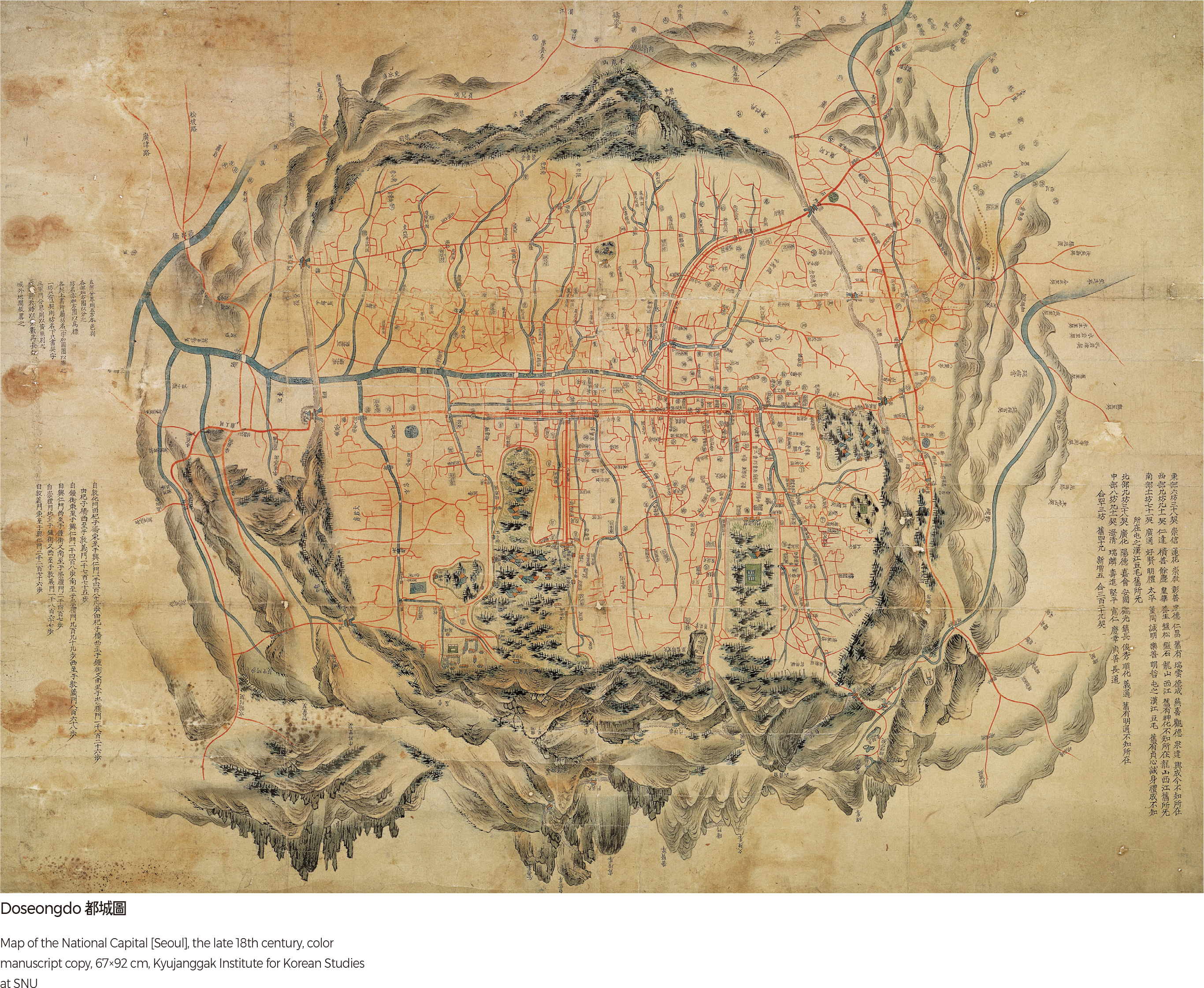
Doseongdo
With Dobongsan Mountain and Bukhansan Mountain in the background, this map depicts the beautiful natural environment of Seoul in the form of a landscape painting along with the mountains of Baekaksan, Inwangsan, Mokmyeoksan (present-day Namsan), and Taraksan (present-day Naksan), which are collectively called Naesasan. In-town landscapes were drawn vertically and marked with place names. The planar description is intentional to contrast with the surrounding mountainous terrain. Written on the margin are descriptions of administrative districts, and the size of the city, roads, and streets with Donhwamun Gate, the main gate of the Changdeokgung Palace, in the center to highlight Changdeokgung Palace as the main working palace of the country. The map was featured with a south-up orientation to reflect that the king would have sat facing south when taking care of state affairs.
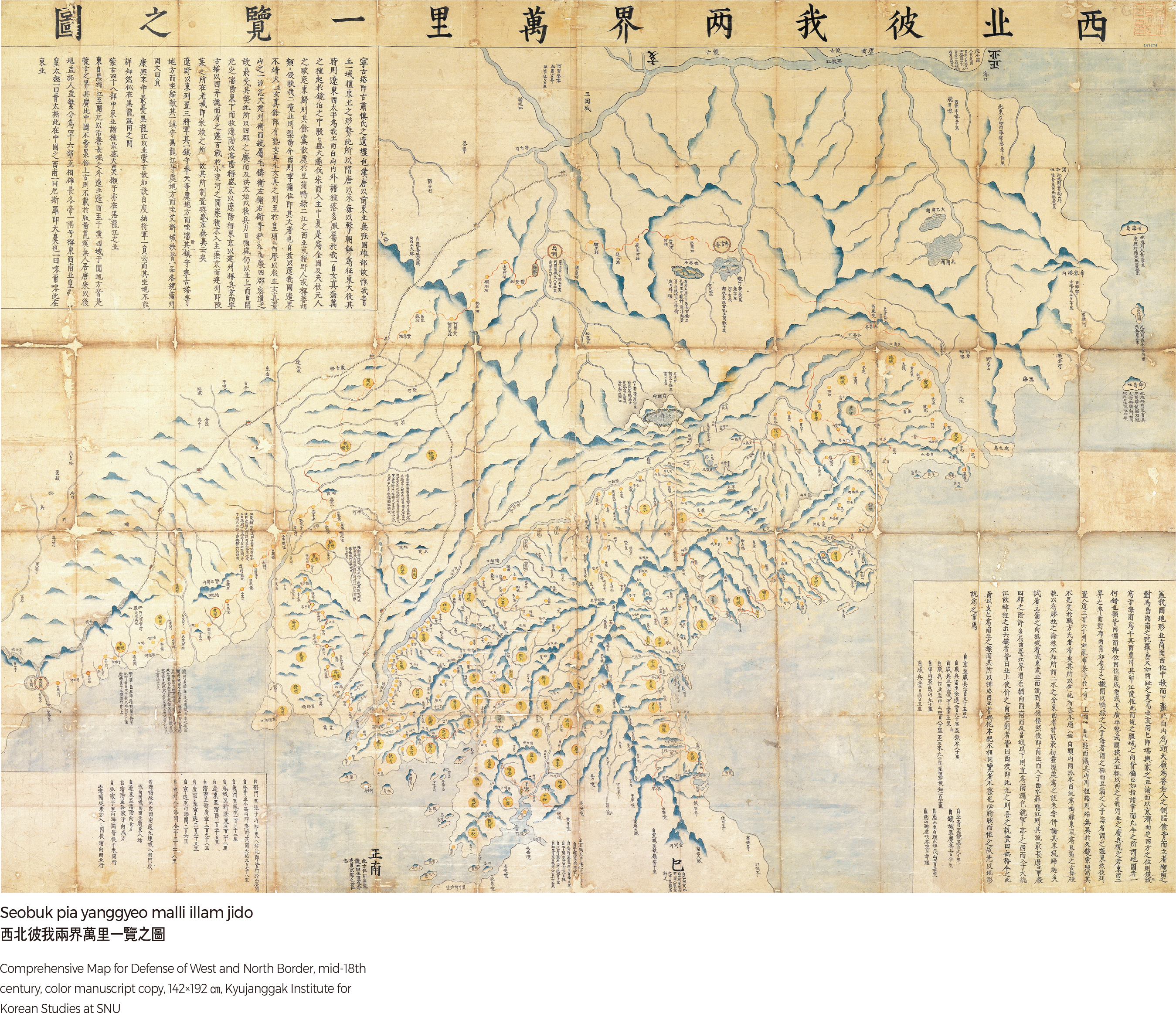
Seobuk pia yanggyeo malli illam jido
This Korean frontier map focuses on the northwestern region of Korea and Manchuria during the Joseon Dynasty. The word “pia” in “Seobukpia” refers to both the Chinese Qing and Korean Joseon Dynasties. As a type of military map, it was designed to defend the country against an invasion from China. The map covers a wide area with Baekdusan Mountain at the center spanning from the Heilongjiang River (Black Dragon River) in Manchuria in the east to Shanhai Pass in the west, delineating post towns and military bases established along the extensive fortress walls and roads. Its map orientation is unique. Instead of aligning the map with a north-south direction, “haejwa sahyang,” the country faces the sa (south-southeast) direction with the direction hae (north-northwest) in the back. Places like Jilin and Ningguta, where the Qing Dynasty was founded, were marked in red.
Giseong jeondo
This panoramic map portrays Pyeongyang in a picturesque style as a boat on the Daedonggang River. Giseong is a nickname for Pyeongyang, which originated from a legend in which Gija took care of a field in Pyeongyang. With Yongaksan Mountainidentified as a guardian mountain in the background, the map displays government offices, roads, place names, and residential areas of the city in detail. Even the streets that sell cold noodles in small towns and villages are labeled. The white stone walls of the internal fortress and the north fortress, various types of boats docked in Daedonggang River, the long forest spreading 10-ri, the pine forest of Ulmildae, the fields outside the Jungseong Fortress, and the earthen ramparts were all skillfully portrayed. The map vividly shows a panoramic view of Pyeongyang 100 years ago.
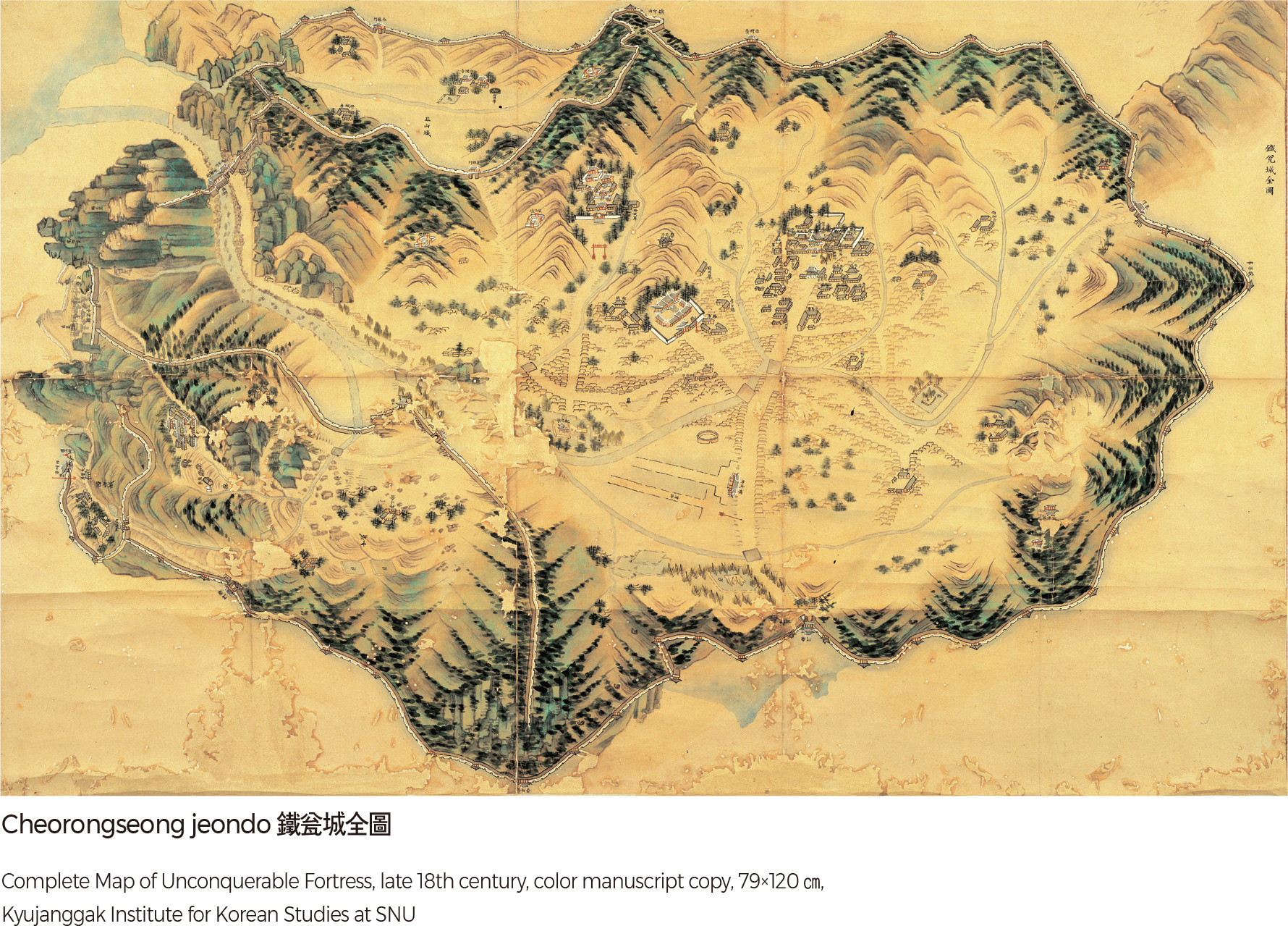
Cheorongseong jeondo
The map describes in detail a wall surrounding Yeongbyeon, which was called an unconquerable fortress. It was the final line of defense in the Gwanseo area. Being surrounded by rugged mountains on all sides meant that it was located in a natural fortress. Even during the Manchu War of 1636, the castle never fell to the Qing army. The castle is comprised of the main fortress, the north fortress, the new fortress, and the west fortress. The south gate was an important gateway that connects Anju and Pyeongyang. The west fortress, also known for Yaksan, is a famously scenic place. Beautiful Yaksan dongdae is well known for “Yaksan Azaleas,” which are mentioned in the poem “Azaleas” by Kim So-wol. |