English I 2019
In the 12th century, Goryeo waged a massive war against the Yeojin Tribe and earned preemptive rights over the Dumangang region. The rights were used as substantial evidence when Koreans had a border dispute in the northeastern part of the Korean Peninsula with Chinese or other northern forces. Entering the Joseon Dynasty, Koreans considered their territory not limited to Amnokgang River or Dumangang River, but extending beyond those rivers thanks to the preemptive rights over Manchuria.
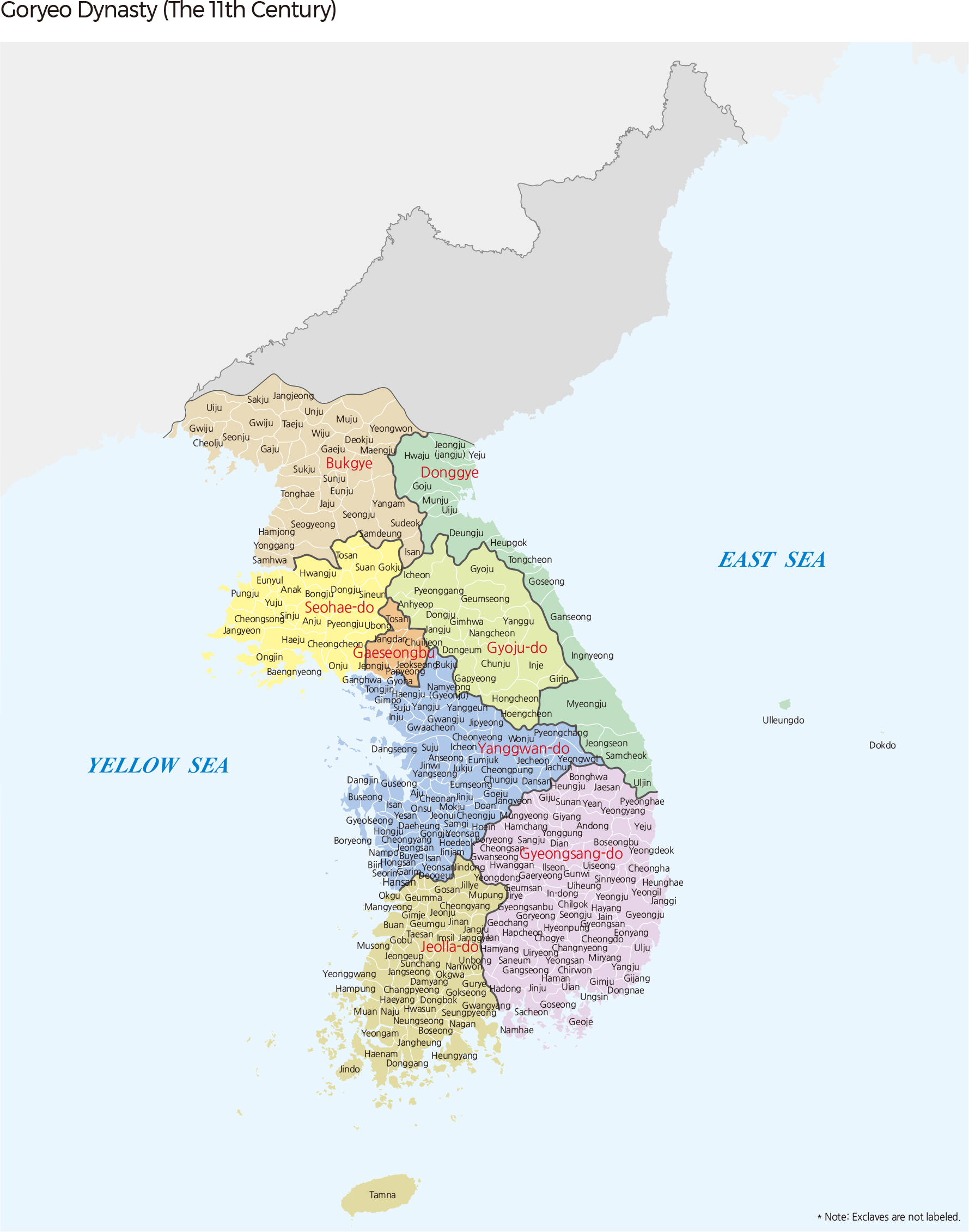
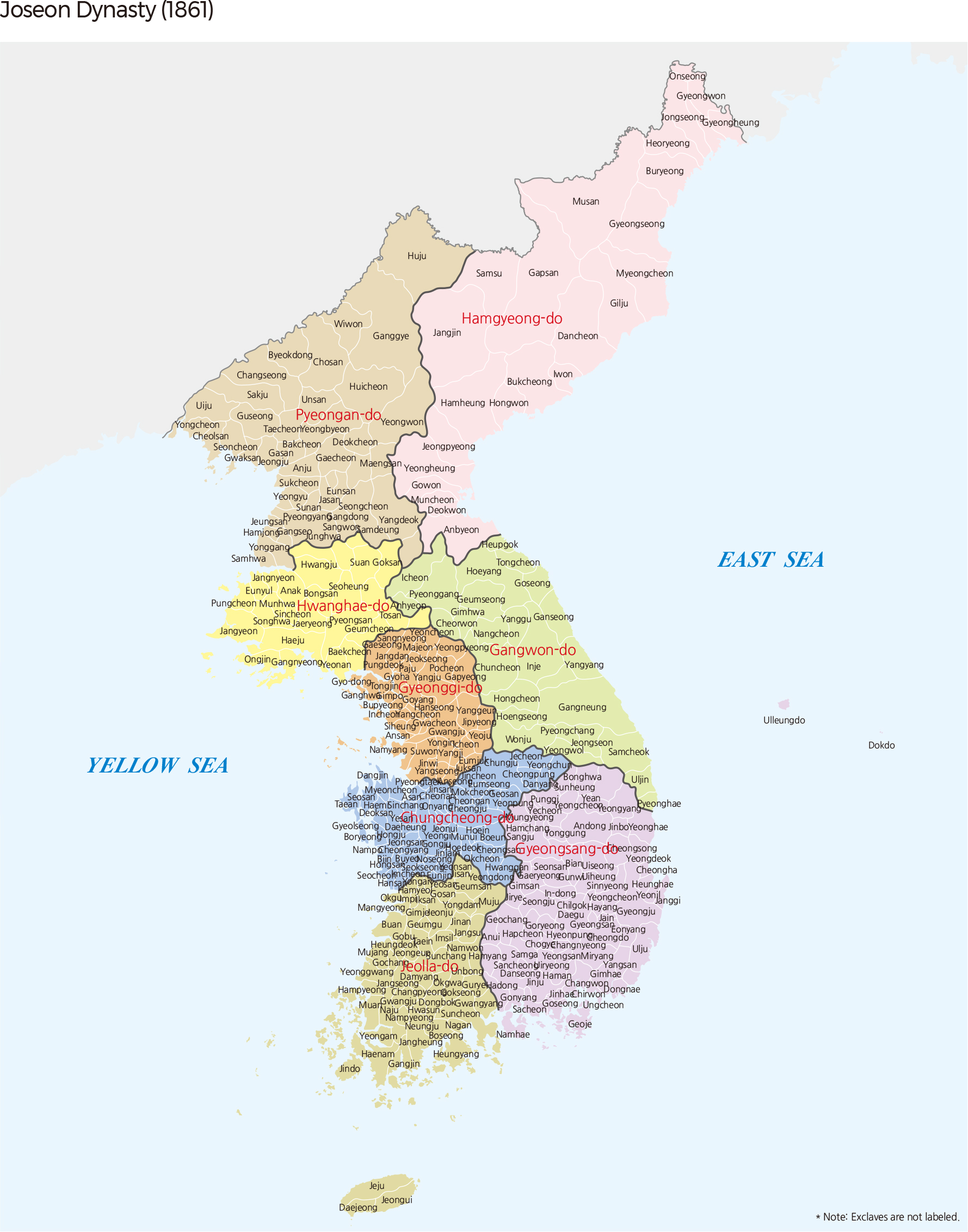
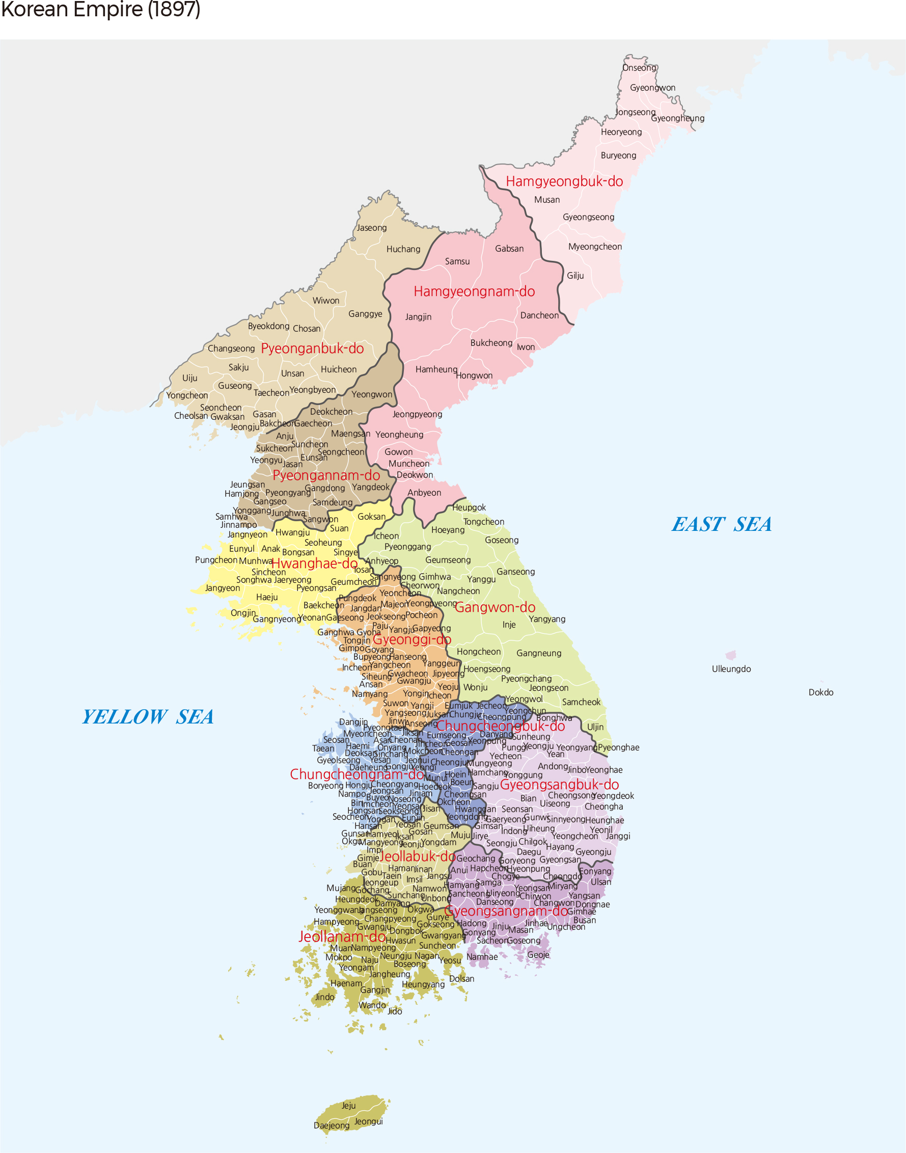
The local administrative bodies were composed of five dos (provinces) and two gyes (military districts) during the Goryeo Dynasty. The five dos, Yanggwang-do, Gyeongsang-do, Jeolla-do, Seohae-do, and Gyoju-do, had local administrators dispatched for administrative affairs and the two gyes, Bukgye and Donggye, located near the border, had generals dispatched. Goryeo consisted of general administrative districts in the south and military districts in the north. Later, the Joseon Dynasty had a unitary system, which consisted of eight dos and this was further reorganized into 13 dos and seven bus in the Era of the Korean Empire.
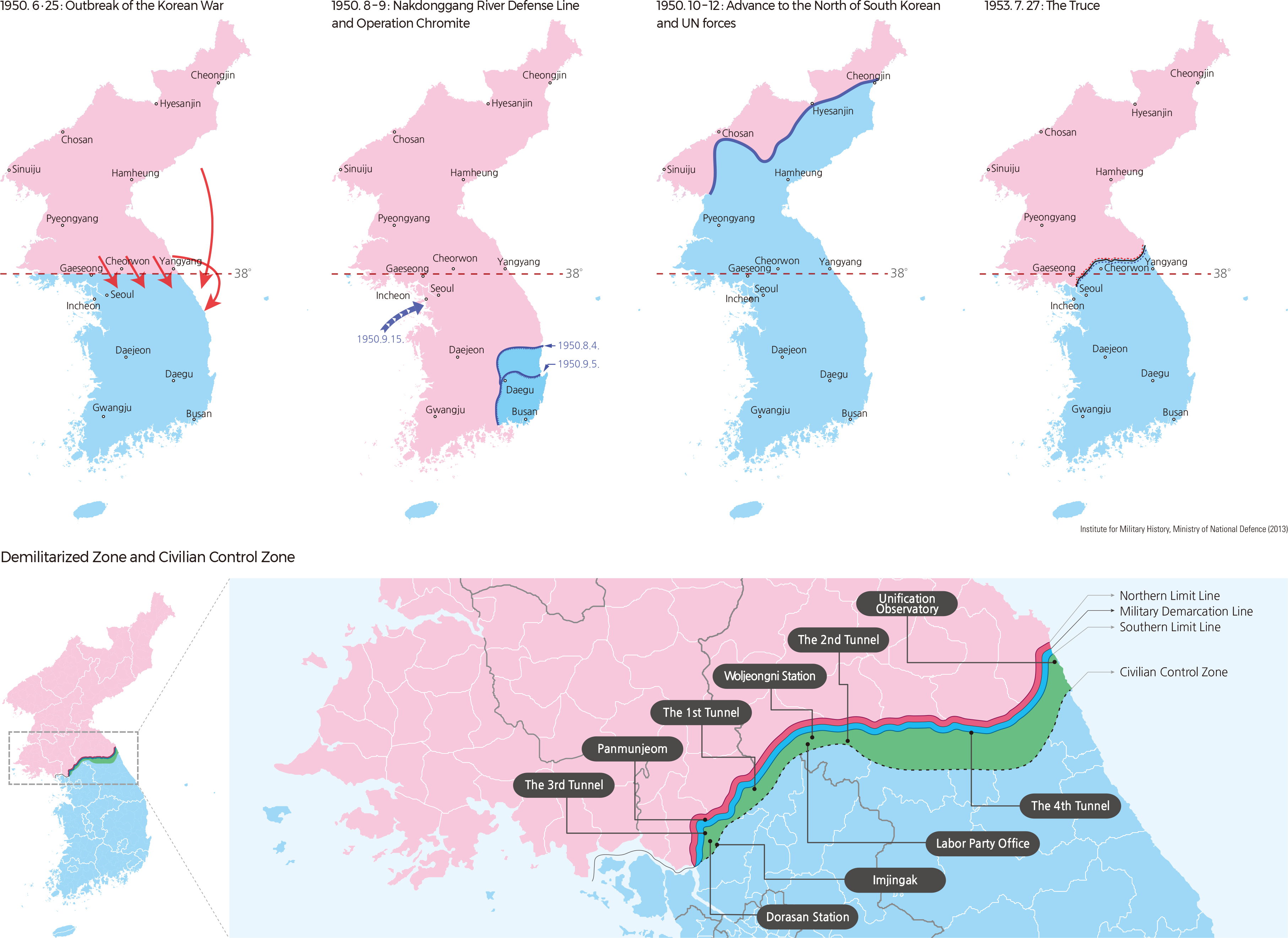
The Demilitarized Zone (DMZ) refers to a buffer zone between the South MDL (Military Demarcation Line) and the North MDL in which arms are prohibited in accordance with agreement or treaty. Military deployment, arms arrangement, and the installation of military facilities are prohibited in the DMZ. Korea’s DMZ was set up by the ceasefire that put an end to the Korean War. When the agreement was signed in 1953, the line of military contact became known as the Military Demarcation Line (MDL), and a 4 km band of land extending 2 km to the north and 2 km to the south of the MDL was designated as the DMZ.
The Civilian Control Zone (CCZ) is a stretch of land that lies between the DMZ and the Civilian Control Line (CCL). The CCL is a line designated to restrict public access in areas adjacent to the MDL where the legal protection of the military is required. The CCL was initially drawn in 1954, and since then three adjustments have been made, reducing the CCZ to resolve property right infringements. The current CCL is designated within 10 km south of the MDL.
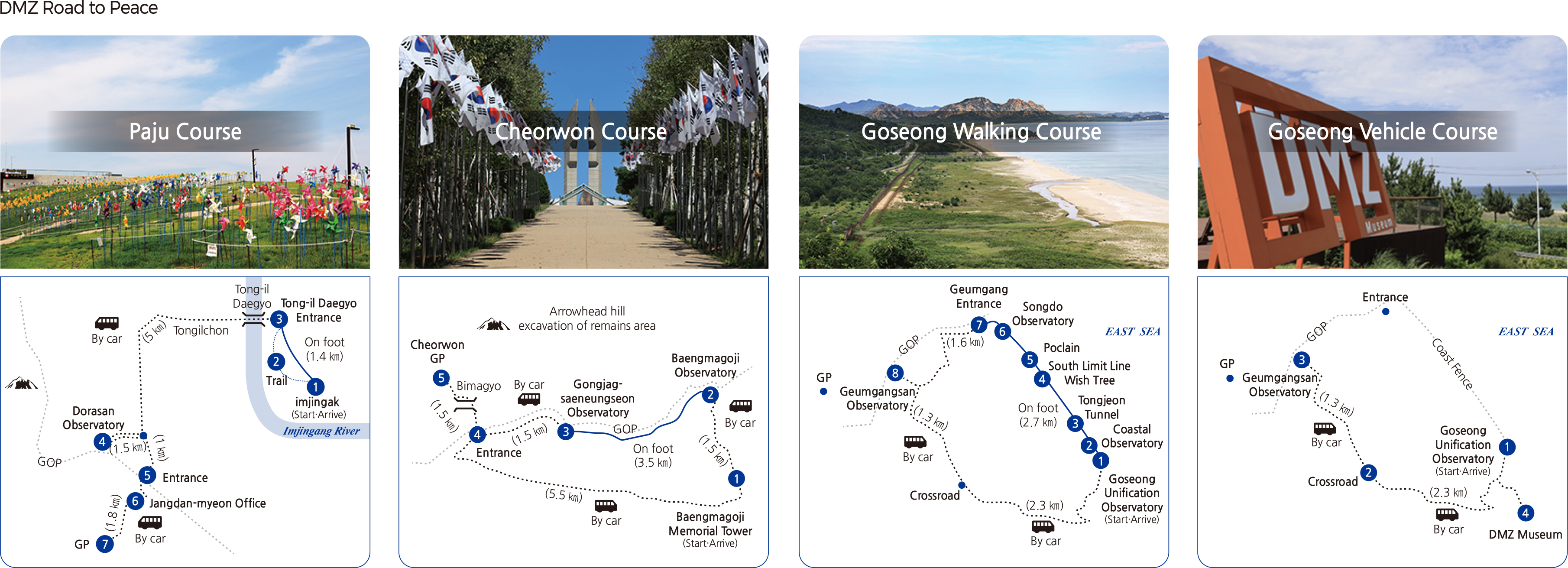
The DMZ and CCZ are the areas where human contact is restricted to a minimum, except for farming activities by a few villages along the CCL. These two zones both have diverse natural environments that are well preserved and that are home to a vast diversity of species. These species include animals listed as Grade 1 endangered wildlife, such as musk deer, mountain goats, otters, white-tailed sea eagles, and golden eagles, and Grade 2 species such as martens, flying squirrels, goshawks, and the Siberian lily. Recently, tourism in these areas has become popular for the well-preserved environment as well as the historic sites that are related to the military activities of the tragic war. In 2018, the North-South Summit agreement and sideline agreements laid a foundation to make the DMZ a zone of peace, and the heads of the two Koreas agreed to make the DMZ a peace zone in the Panmunjeom Declaration announced on April 27th, 2018. The Korean Government promotes the DMZ Peace Trail Project to bring peace to the DMZ and to promote development and prosperity in the border regions. The DMZ Peace Trail Project is provided at three locations (Paju, Cheorwon, and Goseong) where efforts to ease the tension between the two countries are being made through the demolition of the guard posts and joint recovery operations in accordance with the Comprehensive Military Agreement signed on September 19th, 2018. |