THE NATIONAL ATLAS OF KOREA 2024
|
Population and Urban Structure of North Korea
|
.png)
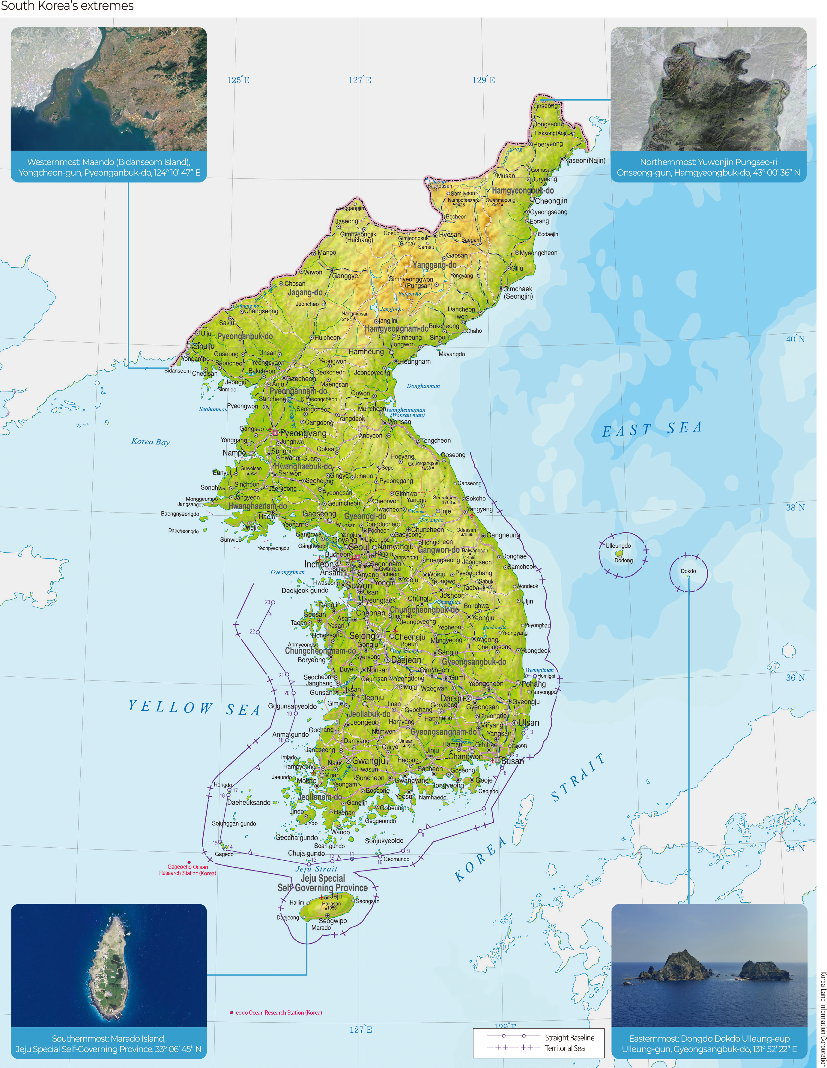
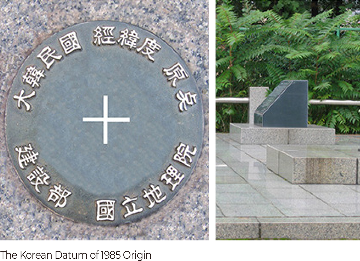

The Korean national territory is primarily recognized as a “location,” which can be divided into absolute location and relative location. Absolute location is determined by longitude and latitude, based on the Geodetic Datum of Korea located at the National Geographic Information Institute. The absolute location of the Republic of Korea is as follows: extreme west at 124° 10′ 47″ east longitude, extreme north at 43° 00′ 36″ north latitude, extreme east at 131° 52′ 22″ east longitude, and extreme south at 33° 05′ 45″ north latitude..
In contrast, the relative location of a national territory is a variable and flexible location influenced by the situation of neighboring countries or other nations. Relative location, which changes according to foreign political, economic, and social relations, is greatly affected by the context of the times and international affairs. Moreover, the changing relative location has significantly influenced the perception of Korea’s national territory among citizens. The depiction of the Korean Peninsula and surrounding areas on old maps often appeared exaggerated or diminished, depending on the relationships with neighboring countries during the Goryeo and Joseon dynasties.
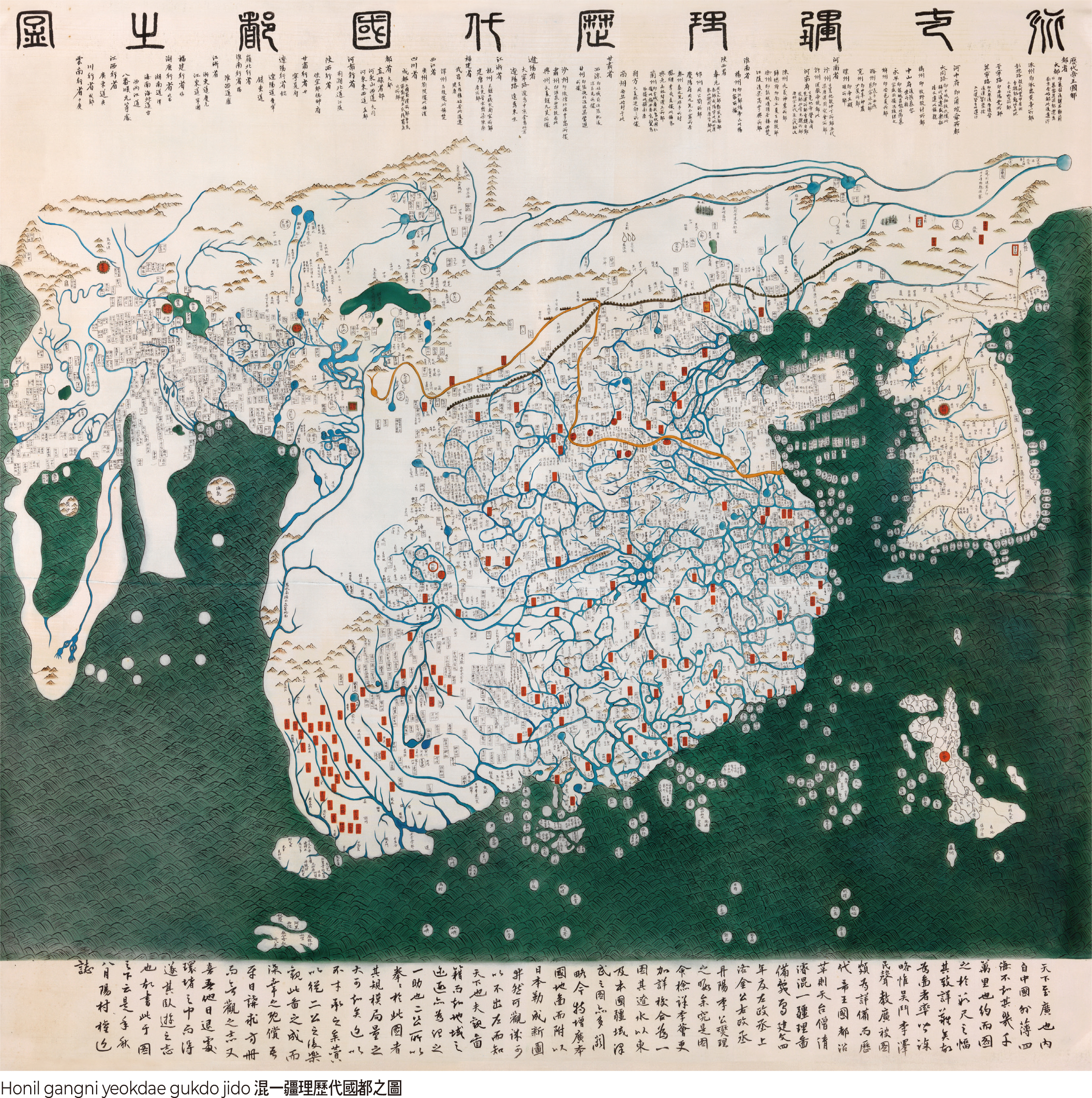
In pre-modern times, the perception of Korea’s national territory was mainly characterized by the division of regions according to the distribution of mountains and rivers. The administrative divisions during the Goryeo and Joseon dynasties were derived from traditional regional divisions, and the contemporary perception of national territory and regions can be found in Taekriji, written by Yi Jung-hwan in the late Joseon period in 1751.
The perception of Korean national territory in the modern era was concretized through geography education following the reorganization of the educational system. Geography textbooks produced by various authors during the late Joseon period, the Korean Empire, and the Japanese colonial period described the absolute location of the Korean Peninsula and, at the same time, organized its relative location mainly through the descriptions of it as a peninsula nation or in relation to bordering countries or seas. In particular, geography textbooks for middle schools published in the mid-1930s described the Korean Peninsula as “the main trunk of world transportation from Siberia to Japan,” highlighting its favorable location connecting the Asian continent and Japan, reflecting the geopolitical implications for Japan and neighboring countries, which sought to expand into Northeast Asia using the Korean Peninsula as a bridgehead. Additionally, these contemporary geography textbooks shaped or reflected a specific perception of national territory through education, likening the shape of the Korean Peninsula to a rabbit, for instance.
The Korean Peninsula lies between the Asian continent and the sea. Korea’s relative location, the perception of the national territory as a peninsula, has been used to explain the repeated invasions and colonization by surrounding powerful nations that Korea experienced in the past. This perception was also used to understand and explain the contemporary situation during the Cold War period following the Korean War. It explained the relative location and geopolitical importance of the Korean Peninsula as a point where communist forces led by the Soviet Union and the liberal camp of the United States and its allies faced each other, emphasizing that our national territory, located on a peninsula and surrounded by powerful nations, inevitably suffered the pains of war as a small nation.
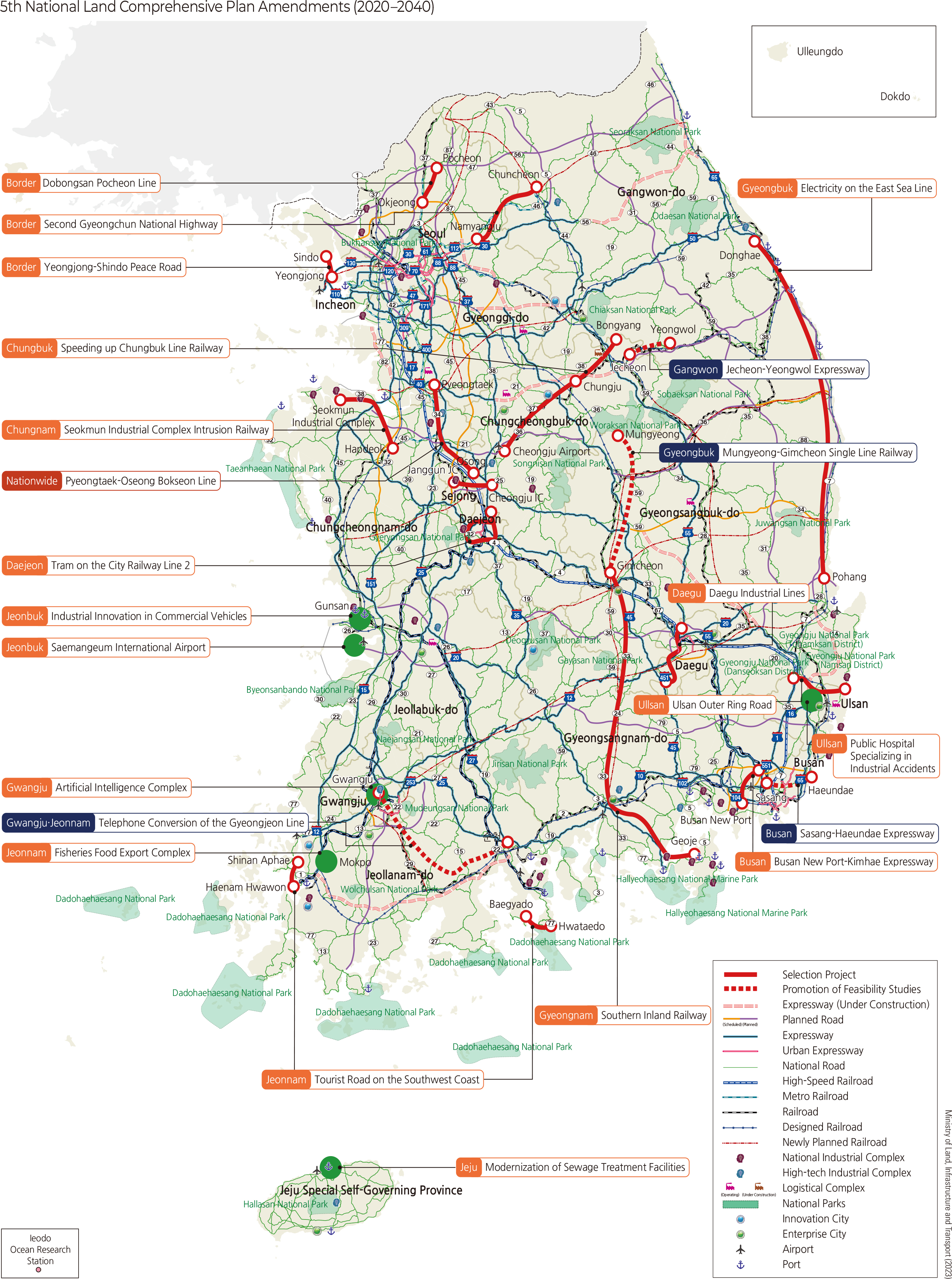
Alongside such geopolitical fears that shaped the perception of our national territory, there was also a perception that interpreted this relative location as a geopolitical hope. In the 1970s, the relative location of the Korean Peninsula, due to its geographical shape and features, was considered an economically advantageous position that could reach out to continental and maritime forces rather than merely enduring invasions. The first Comprehensive National Territorial Development Plan, initiated in 1971, emphasized securing a “bridge to reach out to the world,” with industrial areas located in the southeastern coastal regions of the Korean Peninsula.
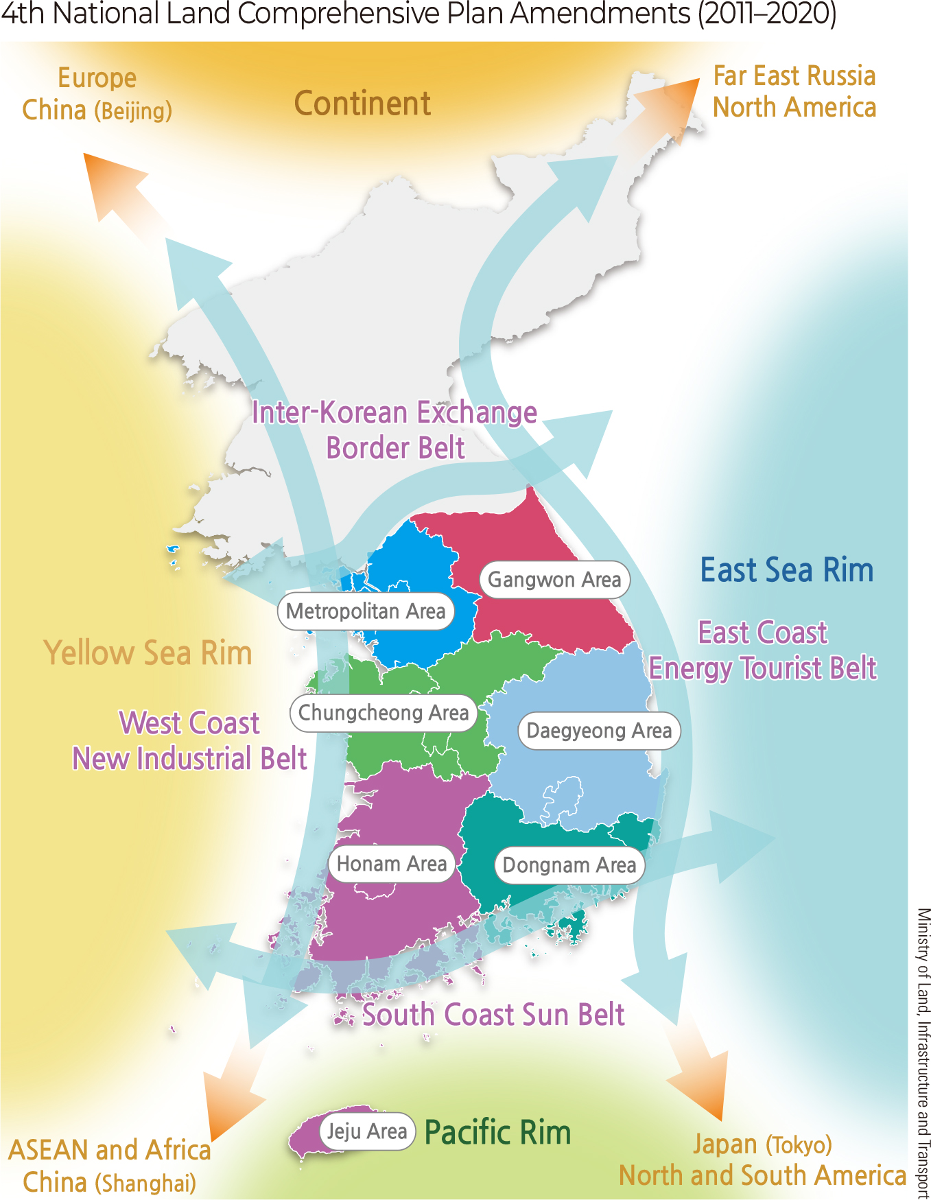
The perception of Korea’s national territory, imbued with geopolitical hope and potential, repeatedly appeared in the Comprehensive National Territorial Development Plans that continued after the 1970s. The fourth Comprehensive National Territorial Development Plan, revised in 2011, emphasized the need to respond to the intensification of global competition and to enhance competitiveness through an open perception of the national territory. Particularly, the Comprehensive National Territorial Development Plan, centered on high-speed transportation means such as airports, ports, and high-speed railroads, and on global infrastructure, expressed the relative location of the country in the global era in a way that completely reversed the peninsular limitations of the past.
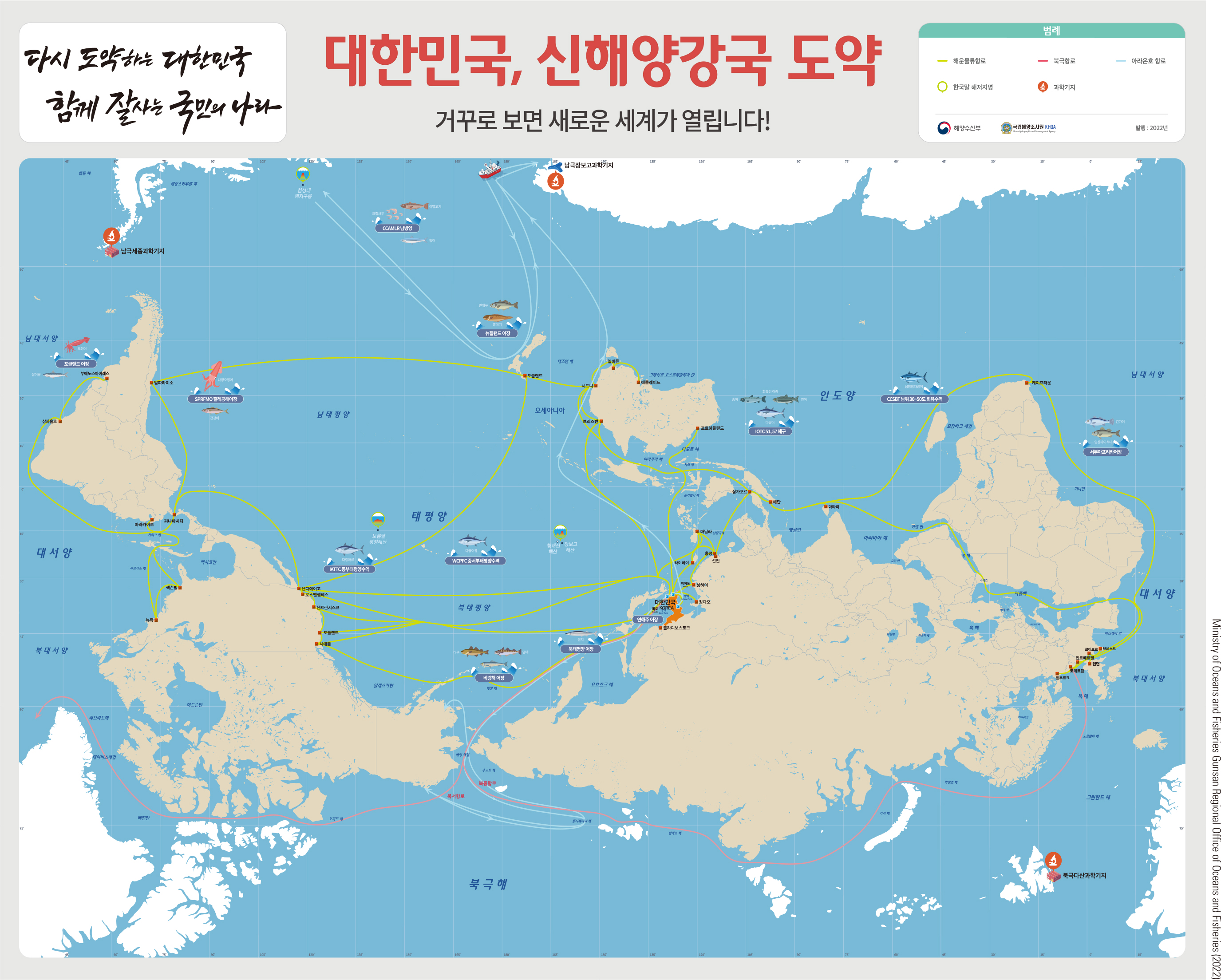
The “Upside-Down World Map,” distributed by the Ministry of Oceans and Fisheries in 2017, was also created with the purpose of enhancing the public’s interest in and perception of the potential of our national territory to extend into the sea. Unlike traditional maps, the “Upside-Down World Map” was created by placing the Northern Hemisphere at the bottom and the Southern Hemisphere at the top, with the Korean Peninsula at the center, spreading out over the vast Pacific Ocean, depicting our country’s proactive maritime policy to advance into the world through the sea routes. This allows for an examination of the achievements of our country’s maritime expansion, such as the development of shipping routes and polar routes and the establishment of polar scientific bases. Minister of Oceans and Fisheries, who served at that time, emphasized through the upside-down map that our national territory, with China and Russia as its hinterland, is akin to a wharf, and thus a strategic location for maritime advancement.
As such, the meaning and value of Korea’s national territory can be understood in quite different forms depending on the combination of numerical and relational positions, international situations, and the political and policy objectives of our country. Therefore, the perception of our national territory can change in different directions through turning points such as the situation of the times and the development of technology. Based on an understanding of the variability of such perceptions, the National Atlas of Korea aims to reflect our nation’s values regarding national territory and confirm our national identity in line with its editorial intent.
|
National Geography Information Institute (NGII) Copyright, |
 |
Ministry of Land Infrastructure and Transport 국토교통부 국토지리정보원 |
|---|