THE NATIONAL ATLAS OF KOREA 2024
|
Location and National Territory
|
.png)


The Korean Peninsula lies between 33 and 44 degrees north latitude and 124 and 132 degrees east longitude and has a cool, temperate climate. Korean Standard Time (KST) is nine hours ahead of England, where the prime meridian passes through Greenwich. The Peninsula is surrounded on three sides by water. The edges of Korean territory, including the Peninsula and its islands, can be traced from its westernmost point, Bidanseom Island (Maan-do, Yongcheon-gun, Pyeonganbuk-do), to Yuwonjin, Onseong-gun, Hamgyeongbuk-do at the northernmost point, to Dokdo, Ulleung-gun, Gyeongsangbuk-do at its easternmost point, and finally, to its southernmost point at Marado Island (Seogwipo-si, Jeju Special Self-Governing Province) and back to the west.
The total size of Korea’s territory is 223,658 km² (North and South combined), which ranks Korea 85th among the 230 countries around the world. In comparison to other countries in the world, Korea is slightly larger than Guyana (214,970 km²) and Belarus (207,600 km²) and around two-thirds the size of the Philippines (300,000 km²), Vietnam (331,340 km²), and Japan (377,970 km²). The size of the Korean territory is similar to that of Uganda (241,550 km²), Ghana (238,530 km²), Romania(238,400 km²), and Laos (236,800 km²). The total area of South Korea alone is 100,444 km², which ranks it 110th in the world, and the area of North Korea is 123,214 km², which ranks it 100th in the world.
The average land area of countries around the world is 617,960 km². Countries of approximately this size include Norway (624,500 km²), the Central African Republic (622,980 km²), Ukraine (603,550 km²), Madagascar (587,300 km²), and Botswana (581,730 km²). These countries are ranked in the top 50 for land area. Countries whose territories are close to the median size include Croatia (88,070km²), Azerbaijan (86,600 km²), Jordan (89,320 km²), Serbia (84,990 km²), and Austria (83,880 km²).
Korea’s land area (North and South combined) is smaller than the global average but bigger than the global median. If the few nations with vast territories such as Russia, Canada, and the United States are excluded from the global average, Korea shows no significant difference from the average nation in terms of land area.
The land area of Korea has steadily increased from 220,109 km² in 1980 to 223,657 km² in 2022. The territorial area of South Korea alone increased from 98,011 km² to 100,444 km² during the same period. In 2010, the area of the South exceeded 100,000 km² for the first time. The land expansion was largely due to reclamation projects. Estuary banks and floodgates were built, breakwaters were erected to block the sea, and former tidelands were changed to create land for agriculture, industry, residence, and public facilities. Through extensive reclamation projects, the land area continues to increase gradually.
Agricultural land expansion and large-scale reclamation projects began in earnest in the 1960s and 1970s. Along the West and South Seas, the government led large-scale reclamation projects to secure more agricultural land. In the 1980s, the private sector joined the projects. Since the 1990s, the awareness of and interest in the value of reclaimed lands have grown. Various aspects such as environment, ecology, landscape, and education have been balanced to ensure that the impact of agricultural and industrial use of reclaimed land is minimized. In the 2020s, advancements in technology have contributed to growing interest in utilizing reclaimed lands for the development of diverse urban areas and residential zones.
The northern part of the Sihwa District (near Ansan and Siheung) was developed into a multi-functional high-tech complex through the Sihwa Multi-Techno Valley (MTV) project in 2023. The southern part of the Sihwa District (near Hwaseong) is being developed into an eco-friendly mixed-use city called Songsan Green City, with completion targeted for 2030. The Saemangeum District in Jeonbuk Special Self-Governing Province is continuing development as a national industrial complex, with a completion goal of 2030. Currently, it is attracting numerous companies and large-scale investments. In 2023, it was designated as a National Strategic High-Tech Secondary Battery Specialized Complex, where core secondary battery industries are clustered. Additionally, many reclaimed lands are being repurposed and developed.
Dokdo is a set of islets of the Republic of Korea that are located at the easternmost edge of the national boundary in the East Sea, Dokdo-ri, Ulleung-gun, Gyeongsangbuk-do, Korea. Dokdo has been a part of the Korean territory since General Isabu of the Silla dynasty claimed Usanguk (The Kingdom of Usan) for Silla in 512. Dokdo has historically been referred to by various names such as Sambongdo, Gajido, Usando, Jasando, and Seokdo.
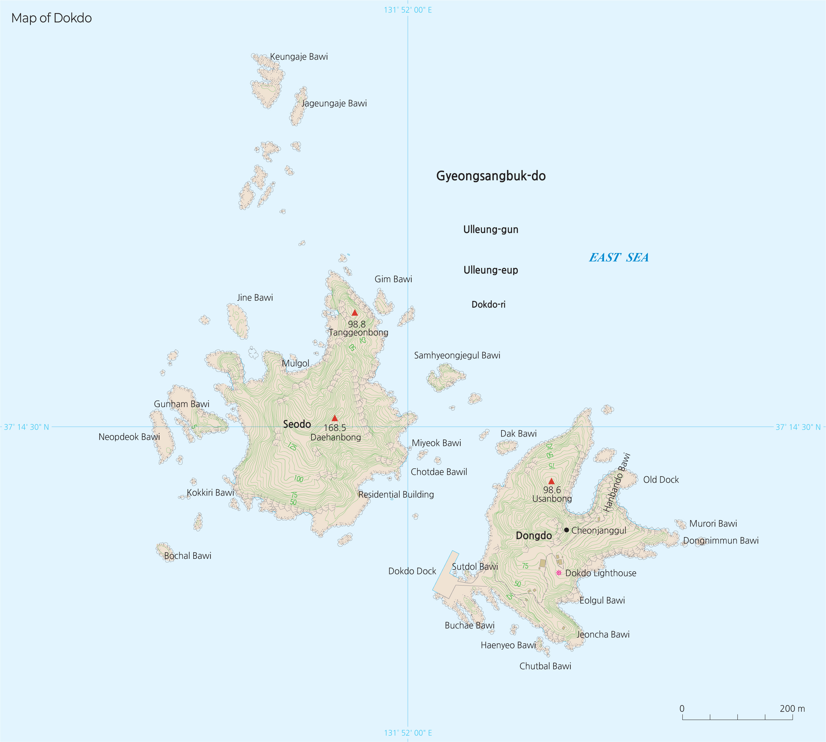
According to Korean historical records, the administrative name of “Dokdo” was first used in 1906 by magistrate Sim Heung-taek of Ulleung-gun. Dokdo was officially incorporated into Gyeongsangbuk-do in 1914. Dokdo is actually not one island, but consists of two large islets, Dongdo (East Island) and Seodo (West Island), and 89 smaller islets, with a total area of 187,554 m². The shortest distance between the two main islets is 151 meters at low tide. Dongdo is located at 37º 14′ 26.8″ N, 131º 52′ 10.4″ E, and Seodo is at 37º 14′ 30.6″ N, 131º 51′ 54.6″ E. Dokdo is 87.4 km east of Ulleungdo and 157.5 km northwest of Oki Island of the Shimane Prefecture of Japan. Dokdo is visible from multiple points on Ulleungdo, which has itself always been regarded as Korean territory. In the Sejong sillok jiriji (Geographical Records in the Annals of King Sejong, 1454), it is noted that the two islands of Usan (Dokdo) and Mureung (Ulleungdo) lay not far apart, and are visible to one another on a clear day.
The Korean government has confirmed through various historical archives that Korea has long recognized Dokdo as its territory. Along with the Sejong sillok jiriji, Sinjeung dongguk yeoji seungnam (The New and Expanded Complete Conspectus of the Territory of the Eastern Country, 1530), Dongguk munheon bigo (Reference Documents on the Eastern Country, 1770), Mangi yoram (Essentials of Governance, 1808), and Jeungbo munheon bigo (Comprehensive Study of Civilization, Revised and Expanded, 1908) all show consistency in depicting Dokdo as Korean territory
According to the Reference Documents on the Eastern Country, “Ulleung and Usan are part of the State of Usan, and Usan is referred to as Songdo by the Japanese,” reaffirming that Dokdo is Korea’s territory. In 1900, Emperor Gojong of the Korean Empire declared Ordinance No. 41, confirming that Dokdo is in the jurisdiction of Uldo-gun (Ulleungdo) and assigned the Mayor of Uldo-gun to administer Dokdo.
Even Japanese historical documents reveal that Dokdo has always been a part of Korean territory. In the late 17th century, the Joseon government and Edo Shogunate negotiated an agreement regarding illegal fisheries activities, which was called the Ulleungdo Dispute. As a result, the Edo Shogunate officially acknowledged on December 25, 1695, that both Ulleungdo (Jukdo) and Dokdo (Songdo) did not belong to the Tottorihan of Edo Shogunate and placed a ban on Japanese fishing in the Ulleungdo area. Despite that, Japan tried to illegally occupy Dokdo through the Shimane Prefecture Public Notice in 1905. However, the Japanese government acknowledged that Dokdo is a Korean territory before the notice was issued. Another notable example, confirming Dokdo as Korean territory, was the Dajokan Order of 1877, which was published by the Dajokan, the highest administrative organization of Japan at the time. Thus, Japan has acknowledged Korea’s sovereignty over Dokdo throughout history.
Additionally, multiple discussions on the international order before and after World War II have confirmed Korea’s sovereignty over Dokdo. The Cairo Declaration of December 1943 stipulated that “Japan shall be stripped of all islands she has seized or occupied by violence and greed.” The General Headquarters of the Allied Powers issued the two instruction codes SCAPIN-677 and 1033 in 1946 to exclude Dokdo from Japan’s governmental or administrative control. It was also reaffirmed by the Treaty of San Francisco in 1951.
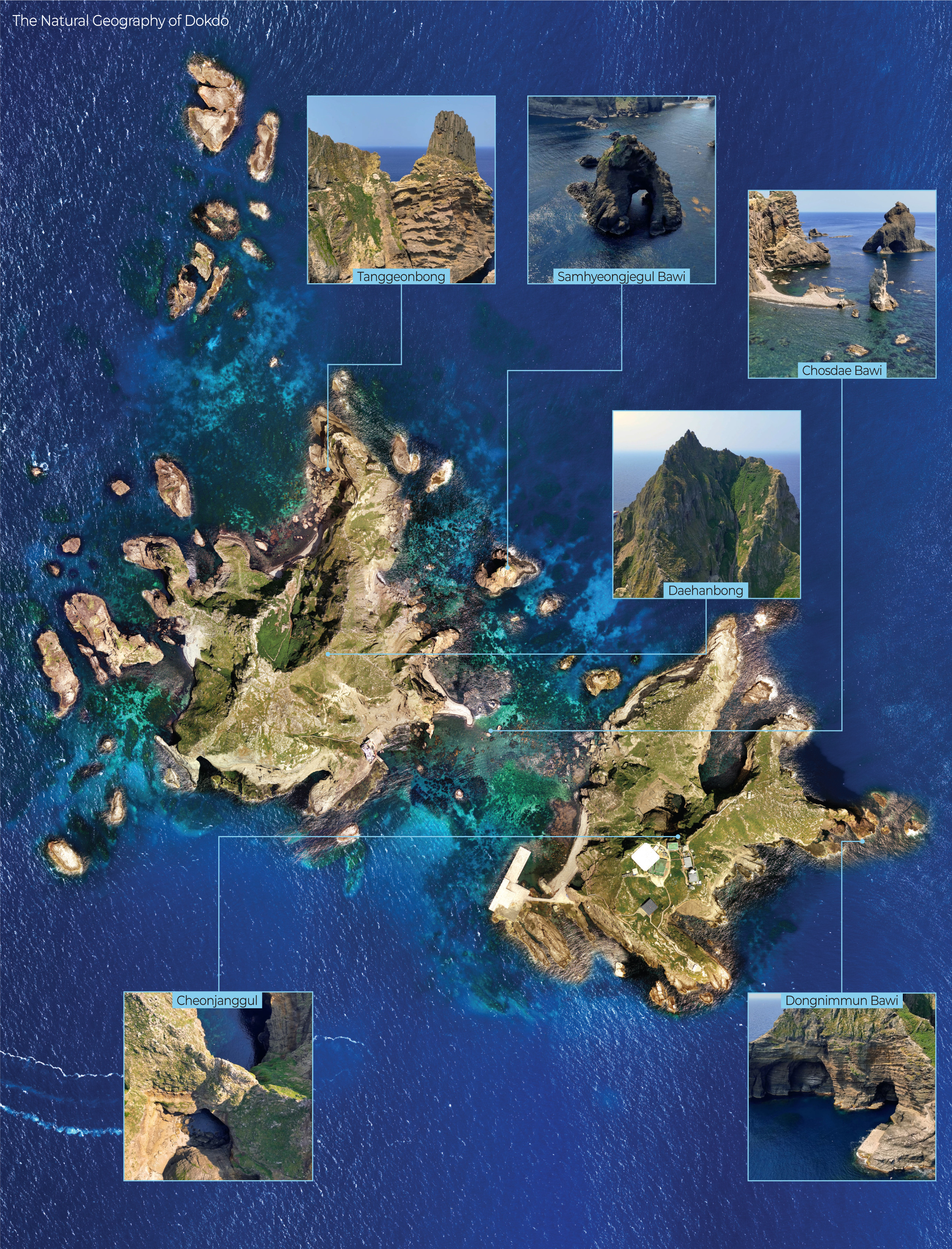
Dokdo is a set of volcanic islets that formed from lava that erupted from about 2,000 m below the surface of the East Sea. Dokdo presumably formed between 4.6million and 2.5 million years ago. It is estimated to have been 2.5 million–10,000years old when Ulleungdo was being formed. Dokdo’s geologic composition is alkaline volcanic rock: the main rocks above sea level are made of andesite, and below sea level, the rocks are believed to consist of basalt. Part of a gigantic, round volcano (the Dokdo Seamount), Dokdo’s highest point is more than 2,000 m above the seafloor, with the radius of the seamount being 30 km at the bottom. As the topographic map shows, the Simheungtaek and Isabu Tablemounts are in the eastern part of the Dokdo Seamount, while the Anyongbok Seamount is located between Ulleungdo and Dokdo.
Surrounded by the Korean Peninsula, Russia, and Japan, the East Sea where Dokdo is located belongs to the group of marginal seas in the North Pacific, running from the Okhotsk Sea to the South China Sea. The North Korea Cold Water (NKCW) and the East Korea Warm Currents (EKWC) meet in the waters around Dokdo, which is located at the center of the East Sea. The seabed in the East Sea near Dokdo consists of three topographic highlands and is more than 2,200 m deep in the west, getting shallower in the east. The strait between Dongdo and Seodo is 110–160 min width, 330 m long, and 5–10 m deep. The waters near Seodo are shallower than those near Dongdo, but the depth of water off Dongdo reaches hundreds of meters.
The waters near Dokdo where the warm and cold currents circulate and meet are rich in zooplankton and phytoplankton. Good environmental conditions are maintained in large part due to the islands’ long distance from land. The sea around Dokdo is relatively undisturbed by human activities, and as a result, it is home to a large diversity of marine life. The waters around Dokdo are abundant with squid and many different types of fish. Squid accounts for more than 60% of the total catch in areas near Dokdo and Daehwatoe Fishery. The drift catches of ray, Korean anchovy, flatfish, saury, yellowtail, blowfish, sea eel, shellfish (such as abalone, conch, and mussel), and seaweeds (such as sea mustard, kelp, agar, and fusiformis). are useful marine resources. Additionally, the trap fishery of red snow crab, shrimp, and sea cucumber results in millions of KRW in profit annually. As of 2018, 379 marine species have been recorded in Dokdo, which includes 220 invertebrate animal species, 110 marine plant species, 21 coral species, and 28 fish species. Most notably, marine plant species and coral species serve to create a rich habitat and spawning ground for a diversity of marine organisms. Additionally, the waters near Dokdo are rich in methane hydrate. Dokdo can be used to establish exclusive economic zone rights for Korea and also can play a pivotal role as an advanced marine base for the Pacific Ocean and a transportation hub in the East Sea.
Dokdo serves as a midpoint rest stop for several bird migration routes. As such, it also serves as an important natural laboratory for scientific research on these birds’ origins and population distribution. A 2005 study confirmed the existence of a total of 25 species of birds in Dokdo and that number increased to 76 in 2013. The huge difference in findings is attributed to the gap in bird species by season, and the variety and diversity of birds according to the research period and frequency. Twenty-two different species of birds are found year-round, and they include blacktailed gull, stormy petrel, shearwater, kestrel, osprey, dusky thrush, swan, harlequin duck, brambling, yellow-throated bunting, white-faced wagtail, golden-crested kinglet, and quail. Among them, the black-tailed gull has the largest population, followed by the stormy petrel, then the shearwater. Eight species are endangered: one first-grade endangered species (the hawk), and seven second-grade endangered species (Siberian honey buzzard, black kite, crested murrelet, owl, osprey, swan, and hooded crane). The shearwaters, stormy petrels, and black-tailed gulls that call the islands of Dokdo home only reproduce in Northeast Asia. Namsa-myeon of Seodo (Dokdo), the west region of Dongnipmun Rock, and the places where the perennial plant couch grass grows are known breeding grounds for the black-tailed gull. The islands also welcome common summer migratory birds (common sandpiper, cattle egret, heron, and streaked shearwater), common winter birds (dunlin, herring gull, and Korean buzzard), and others (snipe, gray-tailed tattler, and common greenshank). for temporary stopovers.
A minimum of 34 species to a maximum of 75 species of plants in Dokdo have been researched by many different organizations; however, a total of 48 groups of species are acknowledged to inhabit Dokdo. From among these, the Ministry of Environment designated 13 groups of floristic regional indicator plants. Along with Japanese black pine, shrubs such as broad-leaf olive, broad-leaf spindle tree, and honeysuckle, and herbaceous plants such as couch grass, aster, hare’s ear, false lily of the valley, holly fern, and red fescue are growing in Dokdo. The honeysuckle is found only in Ulleungdo and Dokdo, and hare’s ear and false lilies of the valley have been designated as protected plants by the Ministry of Environment. Thirtyseven species of insects have been recorded in Dokdo, including dragonflies, earwigs, grasshoppers, cicadas, beetles, flies, and butterflies.
Because of Dokdo’s migratory importance and species diversity, the government designated the islands collectively as Natural Monument No. 336, and the Dokdo Natural Protection Zone was proclaimed on December 10, 1999, and expanded to 187,554 m² on September 14, 2006.
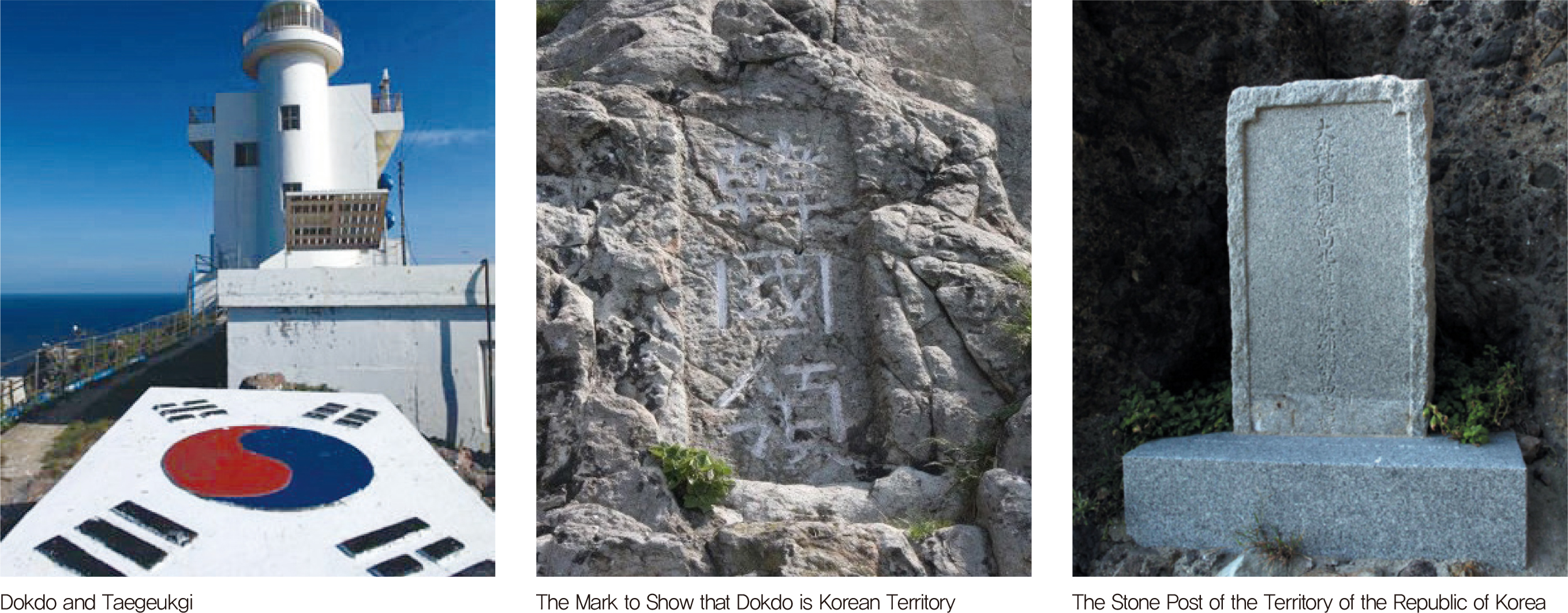
The Republic of Korea exercises its sovereign power over Dokdo by holding legislative, administrative, and judicial jurisdiction over it. First, there is a Korean police force stationed in Dokdo, patrolling the islands. Second, the Korean military defends its territorial waters and airspace. Third, various laws and regulations of the Republic of Korea apply to the islands. Fourth, a lighthouse and docking facilities have been installed, and these facilities are managed and operated by Korea. Fifth,
Korean civilians reside in Dokdo.
Dokdo is classified as an administrative property in accordance with Article 6 of the National Property Act (Management Office: Ministry of Oceans and Fisheries). It consists of 91 islands and 101 lots, and its publicly assessed and individual land prices were published. The construction of the docking facility in Dokdo was completed in November 1997 and was registered in the cadastral records in August 1998. On March 20, 2000, the Ulleung-gun Council passed a bill “Pursuant to Act Amending Ri-Administration,” which was enacted on April 7th, 2000. The administrative designation of Dokdo’s addresses as 42-76, Dodong-ri, Ulleung-eup, Ulleung-gun, Gyeongsangbuk-do, Korea was changed to 1-37, Dokdo-ri, Ulleungeup, Ulleung-gun, Gyeongsangbuk-do, Korea. With the change in the numbering system in Dokdo-ri, it was once again changed in 2016 to 1-96 beonji, Dokdo-ri, Ulleung-eup, Ulleung-gun. Again, with the newly enacted Road Name Address Act, the new road names Dokdoyisabu-gil and Dokdoahnyongbok-gil were selected from a public contest and are in use. Therefore, the current administrative areas are 3, Dokdoahnyongbok-gil, Ulleung-eup, Ulleung-gun, Gyeongsangbuk-do (Residential Building); 55, Dokdoisabu-gil (Dokdo Coast Guard); and 63, Dokdoisabu-gil (Dokdo Lighthouse).
The first registered resident in Dokdo was Choi Jong-deok, and his address was 30 Dokdo-ri (San 67, Dodong-ri), Ulleung-eup, Ulleung-gun, Gyeongsangbukdo. He moved from Ulleungdo to Dokdo in March 1965 to fish commercially and began the construction of facilities in May 1968. He was registered as a Dokdo resident on October 14, 1981, and died on Seodo Island on September 23, 1987. As of December 2019, there were 14 registered residents on the resident registration list. As of August 2023, there are 26 residents in Dokdo, including 20 Dokdo Coast Guard personnel, three lighthouse keepers, and two officers from the Ulleung-gun Dokdo Management Office.
Various government institutions have managed Dokdo for its use and operation. Gyeongsangbuk-do and Ulleung-gun are responsible for administrative services for the islands, such as improving and supporting settlement and living conditions for the residents. The Dokdo Coast Guard is under the command of the Gyeongsangbuk-do Police Agency. The Ministry of Maritime Affairs and Fisheries offers directions for various activities allowing for the sustainable use of Dokdo and its surrounding waters in accordance with Law 7497 on the Sustainable Use of Dokdo Act, enacted on November 19, 2005. Major activities include ecosystem preservation, management, and protection of fishery resources; research and development of marine mineral resources; facility management plans in Dokdo; and the procurement of resources. In an effort to preserve the natural environment
and the ecosystem of Dokdo, the Ministry of the Environment has designated the islets of Dokdo as a “specific island” in accordance with the Special Act on Preservation of the Ecosystem in Dokdo and Affiliated Islands. The Korea Heritage Service designated Dokdo as a natural monument according to the Cultural Heritage Preservation Act and protects the islands. In addition, the Ministry of Interior and Safety is responsible for maritime patrols around Dokdo and ensuring the safety of
passenger ferries to Dokdo.
When Dokdo was first designated as a natural monument for its geological and ecological significance, the government restricted individual trips to the islets to protect the natural environment. As late as the early 1990s, it was difficult for civilians to visit Dokdo except for academic, administrative, or educational purposes. Since visits to the islets were approved on an application basis, more people took an interest in Dokdo, and the number of visitors has increased. However, the numbers were limited to around 1,000–2,000 every year until 2004. In June 2005, the visitation ban was lifted for Dokdo, and the application-based visit became a reporting system. Tourism in Dokdo has ushered in a new era as passenger ships travel between Ulleungdo and Dokdo regularly. The number of visitors has jumped sharply, and the daily visitor quota was raised, allowing up to1,880 people / day. However, it is still limited to 470 persons per group. Since the introduction of the visitor reporting system for the eastern islet of Dokdo in 2005, the number of visitors had reached approximately 3.2 million by December 2023. In 2022, the number of visitors surpassed 280,000 for the first time.
Those who wish to visit Dokdo need to go via Ulleungdo. Historically, the first liner services began between Ulleungdo and Busan in 1912, and services between Ulleungdo and Pohang began in 1963. These services brought expanded connectivity between Ulleungdo and the mainland. With the introduction of the 800-ton, high-speed passenger ships running this route, the number of tourists
to Ulleungdo has drastically increased since 1977. Additionally, the travel time to Ulleungdo has decreased to around three hours. Five passenger ships are in operation between Ulleungdo and Pohang, Mukho, Gangneung, and Hupo. The trip from all of these locations takes approximately three to six hours. For the route between Ulleungdo and Dokdo (docking at Dokdo’s eastern islet), a total of six ships operate, with a travel time of approximately one and a half hours. Passenger ferries between Ulleungdo and Dokdo are typically scheduled to run from March 15 to November 15, depending on weather conditions.
Dokdo, located at the easternmost point of South Korea, holds immense value. It serves as a vital maritime hub for domestic and international sea routes, expands maritime territory, supports monitoring of border waters, protects ecosystems, and preserves biodiversity. Additionally, the seas around Ulleungdo, where cold and warm currents intersect, serve as spawning and habitation grounds for marine life, playing a crucial role in the East Sea’s marine ecosystem. This makes the area an optimal site for studying climate change on the Korean Peninsula. Furthermore, Ulleung-gun, which includes Dokdo, possesses the largest maritime territory among all local governments in South Korea. If Dokdo were lost, an estimated 60,574 km² of surrounding maritime territory would also vanish. To preserve Dokdo, diverse efforts are being made at governmental, local, and civilian levels, recognizing its significant meaning and value.
Since 2016, the Ministry of Education has designated and implemented an annual Dokdo Education Week to promote a proper understanding of the significance and value of Dokdo. Efforts have been made to raise awareness and foster appreciation for Dokdo through programs such as “Knowing Dokdo” education and the establishment of “Dokdo Keeper Schools” for elementary, middle, and high school students. Additionally, the Gyeongsangbuk-do Provincial Government manages the Dokdo Foundation, organizing various academic and cultural events, including Dokdo tours for youth and international visitors.
The civilian organization Dokdo Guardians established October 25 as Dokdo Day to commemorate Emperor Gojong’s proclamation of Imperial Edict No. 41 of the Korean Empire on October 25, 1900, which officially designated Dokdo as an annexed island of Ulleungdo. In 2010, the Korean Federation of Teachers’ Associations (KFTA), in collaboration with 16 provincial and metropolitan teacher associations, the Korean History Education Research Association, the Korea Youth Association, and the Dokdo Research Institute, declared a nationwide Dokdo Day, which continues to be observed to this day.
Since November 2010, the Dokdo Management Office has been issuing Dokdo honorary resident cards to visitors who have visited Dokdo and taken a tour around the islet, for those who wish to become honorary residents of Ulleung-gun. Starting with 44 individuals in 2010, by May 2023, a total of 100,000 people had received honorary resident cards. In total, 140,000 honorary residents were registered as of May 2023. The number of honorary resident cards issued has steadily increased, indicating a growing interest in Dokdo.
The Korean Peninsula’s DMZ (Demilitarized Zone) area generally includes the DMZ established by the Armistice Agreement, the Civilian Control Line (CCL) area defined by the Military Facilities Protection Act, and the border areas specified by the Special Act on Support for Border Regions. It spans 248 km in length. The area of DMZ within South Korea is 453 km².
The DMZ is a buffer zone where military forces are prohibited, as outlined by treaties or agreements. It is an area where the presence of armed forces, deployment of weapons, and the establishment of military facilities are not permitted. The DMZ in South Korea was established following the Korean War, which began on June 25, 1950, and ended with an armistice on July 27, 1953. After the cessation of hostilities, the front line became the Military Demarcation Line (MDL), and a 4 kmwide zone was created, with both North and South Korea agreeing to withdraw their forces 2 km from either side of the MDL. This zone stretches from the mouth of the Imjin River at Jeongdong-ri, Paju, Gyeonggi Province, to Myeongho-ri, Goseong, Gangwon Province, covering a total of 248 km, and is marked by 1,292 signposts.
The border areas refer to military contact zones and their surrounding areas that have faced disadvantages in terms of regional development and private property due to national security concerns following the division of the Korean Peninsula. These areas are defined under the Special Act on Support for Border Regions. The 15 cities and counties covered by this law are located in Incheon (Ganghwa-gun, Ongjin-gun), Gyeonggi-do (Goyang-si, Gimpo-si, Dongducheon-si, Yangju-si, Paju-si, Pocheon-si, Yeoncheon-gun), and Gangwon-do (Chuncheon-si, Goseong-gun, Yanggu-gun, Inje-gun, Cheorwon-gun, Hwacheon-gun).
The area extending from the mouth of the Imjin River to Mal Island in Ganghwa is designated as the Hangang River Estuary Neutral Zone, a special area jointly managed by North and South Korea. In 1953, the Northern Limit Line (NLL) was established as a military control line to limit South Korea’s naval and air patrol activities in the East and West Seas.
The DMZ, having been free from human activity for an extended period, has developed a rich and unique ecosystem. Since the Korean War, the restrictions on military operations and civilian access have resulted in an excellent refuge for various wildlife, allowing for a unique process of ecological restoration. With its diverse range of forests, valleys, wetlands, reed fields, marshlands, and mudflats,
the DMZ is a paradise for a variety of wildlife, including numerous rare species of plants and animals. Rather than being a “preserved ecosystem,” the DMZ is characterized as a “unique ecosystem,” where biodiversity is richly maintained in specific areas under harsh environmental conditions influenced by military activities and restricted civilian access. It possesses a distinctive natural ecosystem rarely found elsewhere and serves as an invaluable site for studying post-war changes in the natural environment. It is regarded not only as a treasure trove of South Korea’s natural ecology but also as one of the world’s most valuable ecological areas.
The DMZ, spanning 248 km across the central region of the Korean Peninsula, forms an unbroken ecological corridor from east to west, serving as a crucial part of the East-West Ecological Axis. Along with the Baekdudaegan, which serves as the North-South Ecological Axis, the DMZ plays a key role in connecting the Peninsula’s core ecosystems. The East-West Ecological Axis is divided into three main regions: the eastern mountain area, the central-western inland area, and the western region. The eastern mountain region, ranging from the Baekdu-daegan to the Hanbuk Jeongmaek and encompassing the North Han River Basin, consists of high mountains and dense forests, with the Hyangnobong area maintaining a nearpristine ecosystem. The summit of Daeamsan Mountain is home to South Korea’s only high-altitude swamp, Yongneup. The central-western inland region, including the Cheorwon Plain and Yeoncheon in the volcanic area of the Hantan River Basin, is shaped by the Imjin River. The western region, encompassing the Han River and Imjin River Estuaries, is a brackish zone with expansive wetlands and mudflats, and the Han River Estuary is the last remaining natural estuary in South Korea. The habitats and land cover across the DMZ area range from mountainous terrain in the east to the flat landscapes of estuaries and mudflats in the west, creating a striking contrast of high in the east and low in the west.
The DMZ has transformed over time from the ruins of war into a treasure of biodiversity. A 2022 survey revealed that the Korean Peninsula’s DMZ is home to 6,512 species, including 52 mammal species, 277 bird species, 34 amphibian and reptile species, 138 arachnid species, 2,954 insect species, 417 benthic invertebrate species, 136 freshwater fish species, and 2,708 plant species. This represents over 30% of the plant and animal species found on the Korean Peninsula, and includes
44 endangered species, such as the red-crowned crane, black-faced spoonbill, otter, and wild goat, all of which are in urgent need of protection.
The plant distribution in the DMZ area is also unique. It is home to endangered species such as the Arctic starflower, Siberian lily, and Halenia corniculate, as well as endemic species like the Hanabusaya asiatica and Leontopodium coreanum. Additionally, non-native plants like the dandelion and common ragweed are thriving in the area. These alien species are believed to have been introduced during the Korean War through U.S. military supplies.
The DMZ area is home to well-developed wetland ecosystems. These wetlands are widely distributed in various forms, from valley wetlands and lake wetlands in the eastern region to lowland wetlands in the western region. Areas that were once agricultural land and lowlands have developed into wetland ecosystems over the course of more than 60 years since the Korean War. These wetland ecosystems serve as important nesting sites and migratory routes for migratory birds from Northeast Asia, including the red-crowned crane, white-naped crane, and hooded crane. The Han River Estuary Neutral Zone, in particular, has gained international attention as a critical area for protecting migratory birds and was designated as a Han River Estuary Wetland Protection Area in 2006.
The DMZ also boasts a variety of geological landscapes. The Chugaryeong Tectonic Valley, columnar joints along the Hantan River and Imjin River, and the Red Cliffs not only are indicators of the geological history of the Korean Peninsula, but also hold significant value as beautiful tourist attractions. The natural ecosystems of the DMZ, along with its volcanic geological features, were recognized for their value, and in 2020, the Hantan River was designated as a UNESCO Global Geopark.
The Civilian Control Line (CCL) villages were established after the CCL was set up in 1954, when the South Korean government relocated soldiers and residents to create these areas. There are a total of 10 villages within the CCL, including Daeseong-dong Freedom Village in the Paju DMZ and Baegyeon-ri Unification Village in the restricted protection area, along with eight other villages. Although there were once over 100 villages in the CCL, the line has moved northward three times, leaving only 10 villages today. In these villages, agriculture is the primary livelihood, and natural monuments and historical sites in the DMZ area are often utilized as tourist resources.
Most of the villages within the CCL near the DMZ have a higher proportion of non-native residents than indigenous residents, resulting in a mix of different customs and traditions, along with a unique military culture specific to border areas. Over time, however, these distinct cultures have blended and assimilated, creating a unique local culture for each village. The CCL villages can be categorized based on their founding type into self-sufficient villages, reconstruction villages, unification villages, and strategic villages. Although the founding purposes of these villages varied slightly depending on the period, location, and members, these distinctions have become less clear over time.
The Daeseong-dong Freedom Village, located in Paju, Gyeonggi Province, is the only village within the DMZ in South Korea. It is situated 500 meters south of the the Freedom Bridge and about 11.5 km south of Kaesong, with Panmunjom located about 1 km northeast. The village was established when some of the residents who had fled during the Korean War returned to their hometown. It is home to the tallest flagpole in South Korea, standing at 99.8 m. Less than 2 km from Daeseong-dong is the North Korean village of Gijeong-dong, which also serves as a propaganda village, featuring a 158-m flagpole with a North Korean flag. Before the Korean War, Daeseong-dong was part of Josan-ri, Gunnae-myeon, Jangdan-gun, but after the administrative restructuring in 1962, it became part of Gunnae-myeon, Paju City. The residents of Daeseong-dong primarily earn their living through rice farming and the cultivation of beans, red beans, and peppers. While Daeseong-dong is under the control of the United Nations Command, it is practically governed by the South Korean government. Due to its location within the DMZ, the village faces several restrictions, including limited freedom of movement. Only direct descendants of people who lived in the village at the time of the armistice are allowed to reside there, and the process for securing residency rights is stringent, meaning that the population of the village has remained largely unchanged over the past 60 years. It is nearly impossible for the general public to visit the village, except for relatives and direct family members who have received permission from the United Nations. As a result, access to Daeseong-dong has been strictly controlled since the armistice, and the area around the village remains well-preserved.
Meaning and Value of the DMZ
The DMZ is a region with a pristine ecological environment untouched by human activity, and it has served as the heart of history for an extended period, making it a historical museum of the Korean Peninsula. Since the armistice of the Korean War, the DMZ has remained undisturbed by human presence. This unique characteristic has naturally enhanced the historical, security, ecological, and cultural value of the DMZ.
The lower Han River and its surrounding areas at the western end of the DMZ have been at the center of Korean history from ancient times to the present. The Silla Kingdom, which occupied this region, unified the Three Kingdoms, including Goguryeo and Baekje. Later, Gaeseong, the capital of Goryeo, became the center of power and was the location where the armistice agreement of the Korean War was signed, as well as the site of the Kaesong Industrial Complex, a symbol of inter-Korean exchange. The capital of the following Joseon dynasty, Seoul, has also functioned as the central city of the Korean Peninsula for over 600 years, situated at the lower Han River.
More than 70 years have passed since the armistice that ended the Korean War, which lasted for over three years, yet North and South Korean soldiers still face off in the DMZ. As the world’s only Cold War zone, this area serves as a symbolic place for all generations who visit, representing both war and peace.
Foreign visitors to South Korea recognize the DMZ as a unique tourist destination that cannot be found in any other country. With its war relics, records, and cultural resources, the DMZ serves as a site that raises awareness for those who have not experienced war, guiding them to dream of world peace. For those pursuing a world without war, it becomes a place of pilgrimage to the history of war, serving as a venue for both tourism and historical education.
Efforts to peacefully utilize the DMZ have been diverse and ongoing, with initiatives proposed at various times. Notable proposals include the initial suggestion for the “Peaceful Use of the DMZ” on June 12, 1971 (Military Armistice Commission), and the “Proposal for the Construction of a Peace Zone within the DMZ” by President Roh Tae-woo in 1988. These proposals have led to concrete efforts and achievements toward the peaceful use of the DMZ today, such as the first inter-Korean agreement on the peaceful use of the DMZ in 1991 (Inter-Korean Basic Agreement), the start of Mount Geumgang tourism in 1998, the connection of the Gyeongui Line and Donghae Line railways and roads after the June 15, 2000 North-South Summit, and the first product produced at the Kaesong Industrial Complex in December 2004.
|
National Geography Information Institute (NGII) Copyright, |
 |
Ministry of Land Infrastructure and Transport 국토교통부 국토지리정보원 |
|---|