Comprehensive Edition 2022
The weather of a region exerts a strong influence on many other earth-surface processes. Humans are acutely aware of the effects of daily weather variations. Often the most striking difference noticed while traveling far from home is the difference in climate. Climatic variations affect almost all other parts of the natural and human-built environment, partly determining everything from soil types to clothing styles, and from plant communities to architectural designs.
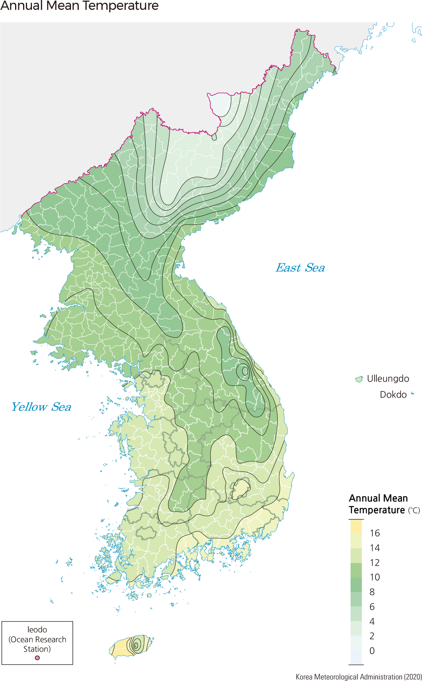
The ‘climate’ of a region refers to the long-term average of weather conditions and the expected variation and extremes of weather throughout the year. Climate is typically classified based on yearly and monthly average temperature and precipitation. The spatial pattern of climate across Korea is determined by factors such as latitude, elevation, proximity to water, and the direction of ocean currents. Most of Korea is characterized as a continental climate with hot summers and dry winters due to the proximity to the Eurasian continent and the influence of the East Asian Monsoon system. The climate of the coasts, especially around the southern end of the Peninsula, is greatly influenced by the ocean and is classified as a humid subtropical climate.
The difference in temperature between the north and south is a result of areas closer to the equator receiving more intense solar energy. The annual mean air temperature at Seogwipo (16.6˚C) on the southernmost tip of South Korea is much higher that at Cheorwon (10.2˚C) on the northernmost tip of South Korea, showing the wide range of air temperature at different latitudes. Climate also depends strongly on elevation. The annual mean air temperature at Daegwallyeong (773 m above sea level), the highest weather station in South Korea, is 6.6˚C. Hongcheon occupies a similar latitude but at a much lower elevation (141 m above sea level), and thus has a higher mean temperature of 10.3˚C.
The Asian monsoon system over East Asia (including Korea, China, and Japan) is formed from seasonal shifts in global circulation patterns and the differential heating of land and sea. In winter, cold, dry wind blows from inland Asia across the Korean Peninsula due to high pressure over the continent. During summer, hot and humid wind blows into Korea from the ocean, bringing heavy rains. The climate of Korea is affected by various air masses such as the Siberian, the North Pacific, the Okhotsk Sea, and equatorial air masses.
A useful way to compare climates is to plot temperature and precipitation throughout the year. The resulting graph, a climograph, can show major differences at a glance. The horizontal axis below each plot represents the month of the year from January (1) to December (12). The lines on the graph represent monthly average temperatures throughout the year. Temperature values are read on the left vertical axis and are shown in degrees Celsius. The top-most (purple) line represents average high temperatures, the bottom (yellow) line shows average low temperatures, and the middle (red) line shows the average temperatures. Precipitation, which includes rainfall as well as snow or sleet, is shown as blue bars, read along the axis on the right in millimeters.
As demonstrated by these climographs, summer in South Korea tends to be hot and wet, while winter is cold and dry. In Seogwipo, on Jeju Island, temperature never drops below zero Celsius. Although not shown here, parts of North Korea, and especially the mountainous areas of the far north, have milder summer temperatures and colder winters. |