Comprehensive Edition 2022
Geomorphology of Korea: The Science of Landforms
Geomorphology is the study of landforms, their origins, and their relationship to processes that operate at the earth’s surface. Landforms can reflect present and past environmental conditions, erosional and depositional histories, and the influences of climate change. Geomorphic features are fundamental components of the landscape that can determine many other aspects of the natural environment: soil properties, water quality, microclimate, plant and animal habitats, and many other phenomena and processes.
Korea maintains a National Ecosystem Survey that evaluates the current status of the natural environment. It covers abiotic components (topography, geology, land, and soil) and biotic components (plants and animals). The survey enhances the understanding of geomorphic features, the distribution of plant and animal species, the degree of environmental health, and the value of ecosystem services by analyzing the characteristics of each element. Evaluation of environmental features is based on a general grading system, with Grade 1 features (mapped here) having a high preservation value.
Landforms of Mountainous Regions
The processes of weathering and erosion are dominant in shaping many landforms in mountainous regions. Bedrock that is more resistant to erosion underlies high rugged mountains, while less resistant rocks are eroded to form lowlands, basins, and valleys. South Korea displays a complex topographic regime due to variable bedrock types formed during different geological periods. Many metamorphic rocks originate from the Pre-Cambrian, while granite and other volcanic rocks were formed during the Mesozoic. Many sedimentary rocks were deposited later, during the Tertiary and Quaternary.
Typical eroded and weathered landforms include erosional basins, rock cliffs, rock domes, tors, tafoni, and caves, while depositional landforms include block streams, talus deposits, and upland wetlands. According to the Natural Ecosystem Survey, Grade 1 landforms occur in the high mountain ranges of Taebaeksanmaek and Sobaeksanmaek but are also widely distributed throughout inland areas.
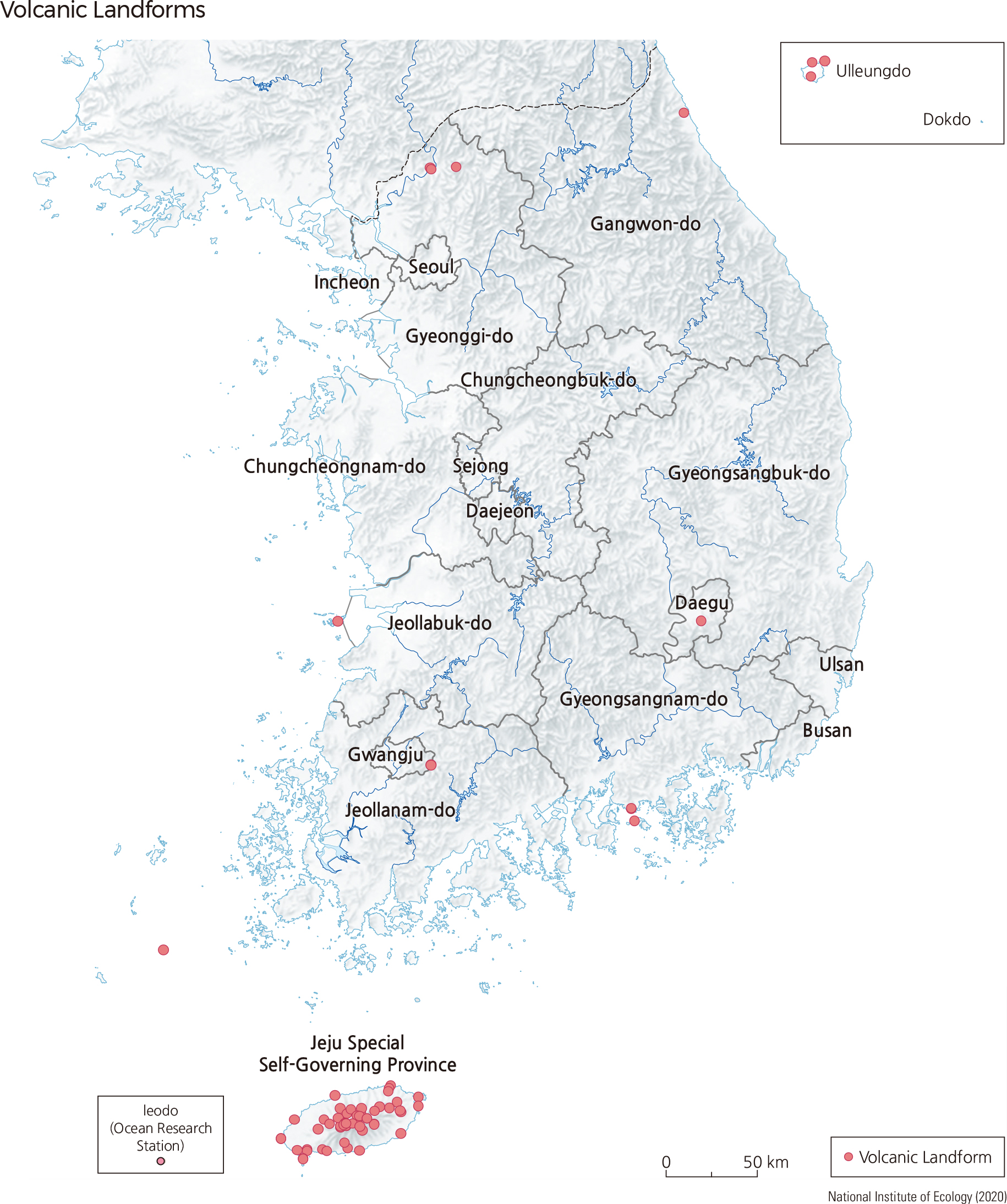
Volcanic Landforms
Although Korea does not currently have active volcanoes, some volcanism occurred throughout the Quaternary Period. As a result, distinct volcanic landforms can be observed in Jejudo, Baekdusan, Ulleungdo, Dokdo, and the Cheorwon Plateau. Jejudo is a volcanic island off the southern coast of Korea, topped by Hallasan peak. Its base was formed by multiple volcanic eruptions over long periods of time as a shield volcano, with gentle slopes and a roughly elliptical shape, extending 73 by 31 km in dimension, with an area of 1,847 km2. Hallasan itself was formed as a more steeply-sloped cone, shaped by volcanic rock known as scoria. Jejudo features diverse volcanic landforms that are not generally seen on the Korean Peninsula and has recently been designated as a geopark and a UNESCO World Heritage Site.
The islands of Ulleungdo and Dokdo represent exposed peaks of a submarine stratovolcano. Unlike Jejudo, these islands have undergone extensive erosion, resulting in more varied topography. Ulleungdo is a massive volcano that stands at over 3,000 m from the seafloor to its highest peak. |