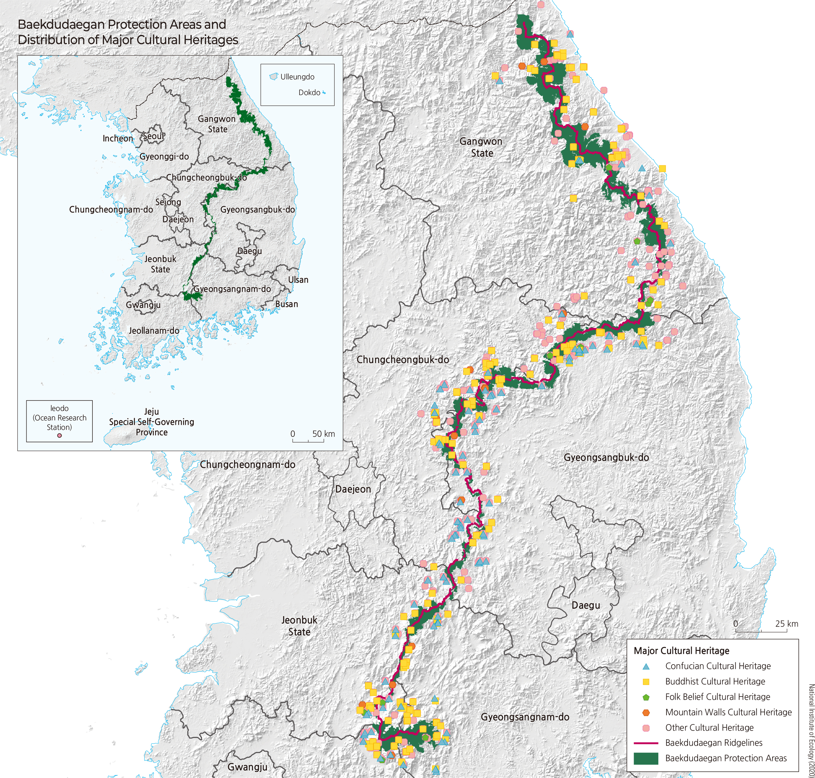
Baekdudaegan is a major mountain range on the Korean Peninsula that originates from Mt. Baekdu, running through Mt. Geumgang, Mt. Seorak, and Mt. Sobaek, down to Mt. Jiri. Stretching total distance of 1,400 km, it connects to 13 jeongmaek (branch ranges), each serving as the source of major rivers. Consequently, alongside the DMZ and island/coastal regions, Baekdudaegan holds invaluable significance as a core ecological axis of the Korean Peninsula and is protected under the Act on the Protection of Baekdudaegan.
The concept of Baekdudaegan first appeared in literature in Okryonggi, written by the Goryeo monk Doseon in the early 10th century. The term daegan (main ridge) was first used in Lee Jung-hwan's Taekriji (1751), while the terms Baekdudaegan and jeonggan (minor ridge) were first documented in Yi Ik's Seonghosaseol (1760). Later around 1770 (during the reign of King Yeongjo), Shin Gyeong-jun systematically organized Korea's mountain ranges in Sangyeongpyo, clearly laying out not only the term Baekdudaegan but also the state, relationships, and order of the connected mountain system extending from Mt. Baekdu to Mt. Jiri.
This region holds immense value from cultural and historical perspectives as well. Each major mountain boasts historic temples integrating scenic landscapes with Buddhist culture, surrounded by scattered tangible and intangible cultural assets, including National Treasures and Treasures. To date, there are 543 nationally designated cultural heritage sites (including 31 National Treasures, 273 Treasures, and 48 Historic Sites), as well as 965 provincially designated sites, 523 cultural heritage materials, and 53 registered cultural properties. In particular, temple forests play a central role in maintaining and elevating the value of the protection area. Among Korea's 935 traditional temples, 173 (19%) are located along the Baekdudaegan, including famous ones such as Baekdamsa (Mt. Seorak), Woljeongsa and Sangwonsa (Mt. Odae), and Hwaeomsa (Mt. Jiri). Temple forests associated with these sites cover 16,571 ha, representing about 10% of the designated protection area.
Today, the Korea Forest Service designates and manages the Baekdudaegan Protection Area pursuant to the Act on the Protection of Baekdudaegan. Four key criteria were applied in designating the protected area: First, as a core mountain range, the Baekdudaegan Protection Area must remain uninterrupted. Second, ecological continuity and connectivity must be secured around mountain ridges. Third, boundaries for core and buffer zones must be defined by ecological indicators such as water systems, mountain topography, and vegetation. Fourth, inconvenience to local residents must be minimized while gathering input from all stakeholders.
Based on these principles and criteria, a total of 263,427 ha was designated and officially announced as the Baekdudaegan Protection Area in September 2005. By ownership type, national forests account for 79% (208,984 ha), public forests 8% (19,905 ha), and private forests 13% (34,538 ha).
The enforcement decree establishing designated maps to legally protect the Baekdudaegan Protection Area was promulgated in November 2019, dividing a total designated area of 275,465 ha into a core zone of 179,095 ha and a buffer zone of 96,369 ha. This mapping provided a formal foundation to prevent damage from reckless development and establish a sustainable management framework.
The 2nd Master Plan for Baekdudaegan Protection serves as a guiding principle incorporating sustainability, connectivity, comprehensiveness, and regionality, as well as a benchmark for evaluating development levels and promoting conservation alongside wise environmental use. Furthermore, efforts for international cooperation are underway by bringing joint inter-Korean management of Baekdudaegan to the agenda, pursuing designation as an IUCN international protected area, and participating in the establishment of a Northeast Asian ecological network.
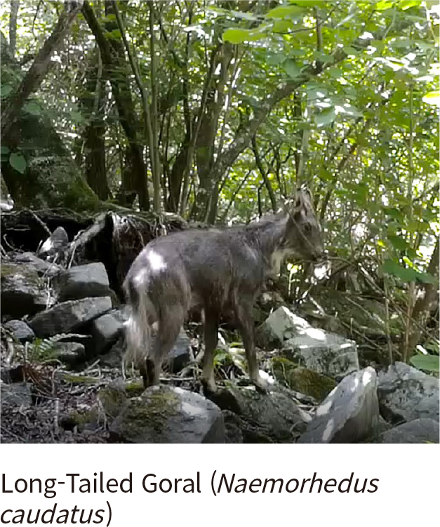
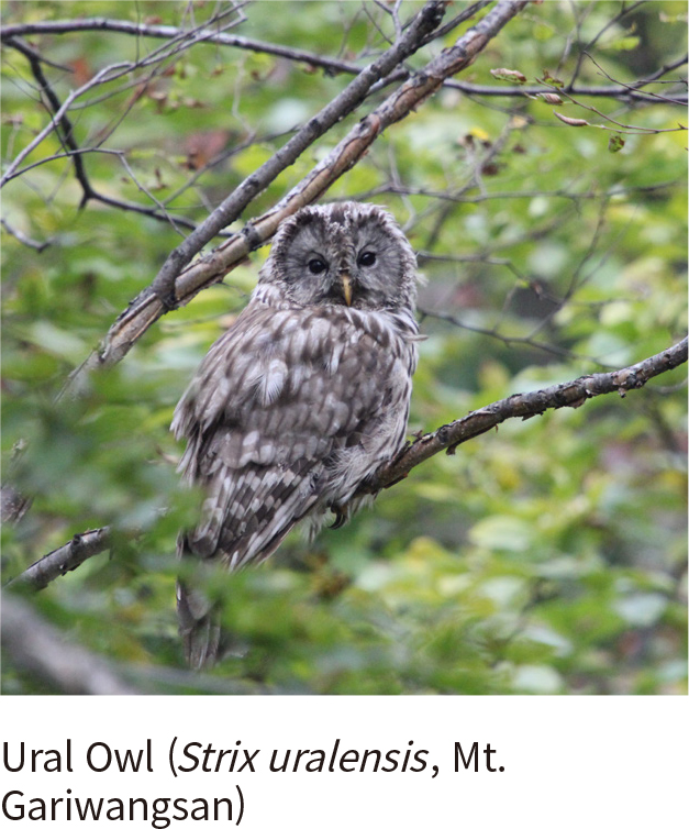
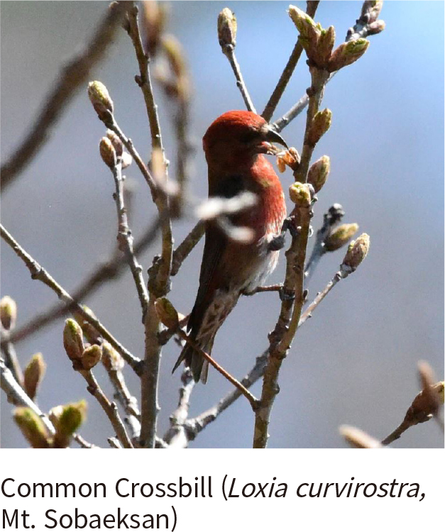
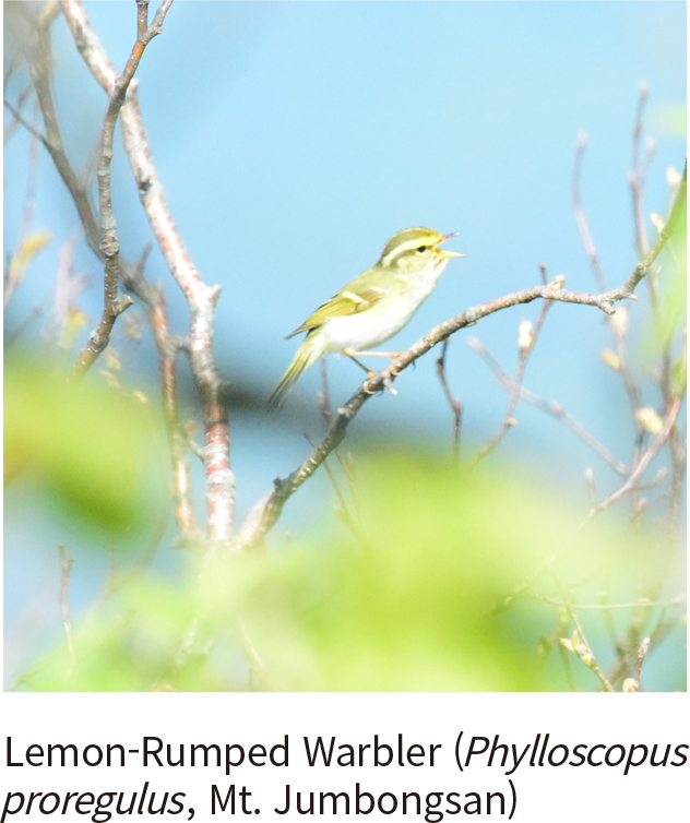
Although Baekdudaegan accounts for only 1.3% of all forest land on the Korean Peninsula, it harbors a rich diversity of life. Surveys to date have identified 1,248 plant species across 126 families and 541 genera (including 3 subspecies, 204 varieties, and 22 forms). It is also home to 23 mammal species (such as flying squirrels, martens, leopard cats, and otters), 91 bird species (including 12 protected species), 11 amphibian species, and 6 reptile species.
Baekdudaegan is a major mountain range on the Korean Peninsula that originates from Mt. Baekdu, running through Mt. Geumgang, Mt. Seorak, and Mt. Sobaek, down to Mt. Jiri. Stretching total distance of 1,400 km, it connects to 13 jeongmaek (branch ranges), each serving as the source of major rivers. Consequently, alongside the DMZ and island/coastal regions, Baekdudaegan holds invaluable significance as a core ecological axis of the Korean Peninsula and is protected under the Act on the Protection of Baekdudaegan.
The concept of Baekdudaegan first appeared in literature in Okryonggi, written by the Goryeo monk Doseon in the early 10th century. The term daegan (main ridge) was first used in Lee Jung-hwan's Taekriji (1751), while the terms Baekdudaegan and jeonggan (minor ridge) were first documented in Yi Ik's Seonghosaseol (1760). Later around 1770 (during the reign of King Yeongjo), Shin Gyeong-jun systematically organized Korea's mountain ranges in Sangyeongpyo, clearly laying out not only the term Baekdudaegan but also the state, relationships, and order of the connected mountain system extending from Mt. Baekdu to Mt. Jiri.
This region holds immense value from cultural and historical perspectives as well. Each major mountain boasts historic temples integrating scenic landscapes with Buddhist culture, surrounded by scattered tangible and intangible cultural assets, including National Treasures and Treasures. To date, there are 543 nationally designated cultural heritage sites (including 31 National Treasures, 273 Treasures, and 48 Historic Sites), as well as 965 provincially designated sites, 523 cultural heritage materials, and 53 registered cultural properties. In particular, temple forests play a central role in maintaining and elevating the value of the protection area. Among Korea's 935 traditional temples, 173 (19%) are located along the Baekdudaegan, including famous ones such as Baekdamsa (Mt. Seorak), Woljeongsa and Sangwonsa (Mt. Odae), and Hwaeomsa (Mt. Jiri). Temple forests associated with these sites cover 16,571 ha, representing about 10% of the designated protection area.
Today, the Korea Forest Service designates and manages the Baekdudaegan Protection Area pursuant to the Act on the Protection of Baekdudaegan. Four key criteria were applied in designating the protected area: First, as a core mountain range, the Baekdudaegan Protection Area must remain uninterrupted. Second, ecological continuity and connectivity must be secured around mountain ridges. Third, boundaries for core and buffer zones must be defined by ecological indicators such as water systems, mountain topography, and vegetation. Fourth, inconvenience to local residents must be minimized while gathering input from all stakeholders.
Based on these principles and criteria, a total of 263,427 ha was designated and officially announced as the Baekdudaegan Protection Area in September 2005. By ownership type, national forests account for 79% (208,984 ha), public forests 8% (19,905 ha), and private forests 13% (34,538 ha).
The enforcement decree establishing designated maps to legally protect the Baekdudaegan Protection Area was promulgated in November 2019, dividing a total designated area of 275,465 ha into a core zone of 179,095 ha and a buffer zone of 96,369 ha. This mapping provided a formal foundation to prevent damage from reckless development and establish a sustainable management framework.
The 2nd Master Plan for Baekdudaegan Protection serves as a guiding principle incorporating sustainability, connectivity, comprehensiveness, and regionality, as well as a benchmark for evaluating development levels and promoting conservation alongside wise environmental use. Furthermore, efforts for international cooperation are underway by bringing joint inter-Korean management of Baekdudaegan to the agenda, pursuing designation as an IUCN international protected area, and participating in the establishment of a Northeast Asian ecological network.
Although Baekdudaegan accounts for only 1.3% of all forest land on the Korean Peninsula, it harbors a rich diversity of life. Surveys to date have identified 1,248 plant species across 126 families and 541 genera (including 3 subspecies, 204 varieties, and 22 forms). It is also home to 23 mammal species (such as flying squirrels, martens, leopard cats, and otters), 91 bird species (including 12 protected species), 11 amphibian species, and 6 reptile species.
Overview of the Topography of the Korean Peninsula
THE LAND WE LIVE ON
| Topography
The Korean Peninsula, surrounded by the sea on three sides, possesses a longer coastline than other countries with similar land areas. The East Coast, which has a relatively straight shoreline, stands in stark contrast to the South and West Coasts, which feature highly indented coastlines. As of 2023, South Korea’s total coastline length was measured at 15,297 km, consisting of 9,682 km of natural coastline and 5,615 km of artificial coastline. Since the first official coastline statistics were released, the length of the natural coastline has been decreasing, while the artificial coastline has been increasing.
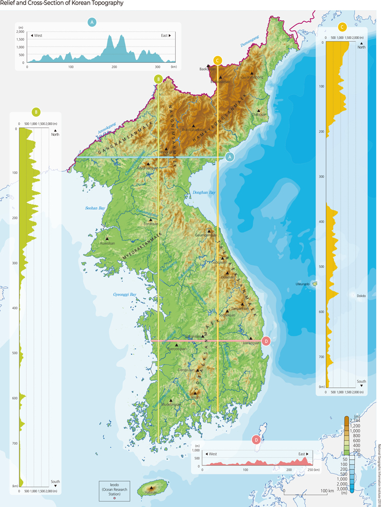
One of the most significant characteristics of the Korean Peninsula’s topography is the prominence of mountainous terrain running in a NNW-SSE (North-Northwest to South-Southeast) direction, specifically the Nangnimsanmaek (Nangnim Mountain Range) and Taebaeksanmaek (Taebaek Mountain Range). The Sikhote-Alin Mountains in the northeast, along with the Hamgyeongsanmaek (Hamgyeong Mountain Range) and Taebaeksanmaek in Korea, were formed as the northern and western margins of the East Sea rim were uplifted during the creation of a back-arc basin along the continental margin. The formation of the Ulleung Basin in the East Sea is closely linked to tectonic uplift of the Taebaeksanmaek.
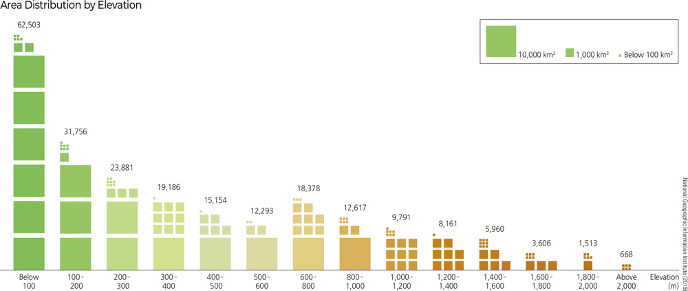
The average elevation of the Korean Peninsula is approximately 448 m, which is significantly lower than the East Asian average (910 m). However, its average slope is 5.7°, which is about 2° steeper than the overall East Asian average of 3.9°. While the Peninsula’s elevation is not high compared to the East Asian average, it is characterized by a high distribution of steep mountainous terrain. Korea’s high mountains are asymmetrically distributed, concentrated in the east and north along the axes of the Taebaeksanmaek, Nangnimsanmaek, and Hamgyeongsanmaek. The Hamgyeongsanmaek includes peaks such as Dojeongsan, Gwanmobong, and Duryusan, while the Nangnimsanmaek features Huisaekbong, Maengbusan, and Nangnimsan, all of which exceed 2,000 m in elevation. The Taebaeksanmaek, stretching approximately 500 km from near Yeongheung Bay in North Korea to Busan, is the principal mountain range of the Korean Peninsula. However, its elevation is much lower than that of the Hamgyeongsanmaek or Nangnimsanmaek, with major peaks like Geumgangsan, Seoraksan, and Odaesan reaching heights of around 1,500 to 1,700 m.
Overview of the Topography of the Korean Peninsula
대한민국 고대의 역사는 만주와 한반도를 중심으로 전개되었다. 기원전 2333년 최초의 국가인 고조선이 만주와 한반도를 중심으로 성립되었으며, 고조선 시대는 기원 전 108년까지 지속되었다. 이후 부여와 동예, 옥저, 삼한의 부족 국가가 성립되었다. 이 시기를 일반적으로 원삼국 시대라 하는데, 이 당시에는 만주와 한반도 전체가 우리나라 역사의 강역이었다. 부여의 세력권은 주로 만주를 중심으로 하였으며, 동예와 옥저는 한반도의 북부와 중부, 마한 진한 변한의 삼한은 한반도의 중부와 남부에 위치하였다.
기원 전 1세기에서 서기 1세기 사이 이전의 부족 국가들을 계승하고 병합하며 고구려, 백제, 신라, 가야가 건국되었다. 이 시기를 삼국 시대라하며, 이 시기 역시 만주와 한반도 전체가 우리나라 역사의 강역이었다. 고구려는 주로 만주와 한반도 북부를 중심으로 하였고, 신라는 한반도의 동남부, 백제는 서남부를 중심으로 하였다. 7세기를 전후로 신라가 고구려와 백제를 병합하며 대동강에서 원산만에 이르는 한반도 내부 영역에서 통일 국가를 이루었다. 그리고 698년 고구려 유민에 의하여 발해가 건국되었다. 이 시기를 남북국 시대라고 한다.
고려 시대와 조선 시대에는 북방 영토를 개척하고 확장하려는 노력이 이루어졌다. 고려는 993년 거란의 1차 침입을 막아 내며 강화 회담을 통하여 강동 육주의 점유를 확인하였고, 1033년부터 천리장성을 축조하여 거란·여진과의 경계로 삼았다. 이를 통하여 현재의 신의주에서 함흥 인근을 잇는 영역으로의 북방 영토 회복을 이루었고, 이후 고려 후기에 이르기까지 북방 영토 확장 노력을 지속하였다. 조선 시대에도 북방 영토 확장을 위한 노력은 계속되었다. 이와 같은 노력의 결과, 15세기 조선은 압록강 유역에 사군을, 두만강 유역에 육진을 설치하였다. 이는 압록강과 두만강에 이르는 현재 대한민국 영토의 회복을 의미한다. 18세기 조선은 백두산 정계비를 세워 당시 중국 청(淸)과의 국경을 표시하기도 하였다.
근대와 현대, 대한민국의 역사는 조선에 이은 대한 제국의 성립, 일본에 의한 강점과 독립, 미국과 구소련에 의한 군정과 한국전쟁으로 이어졌다. 당시 국제 사회의 제국주의 움직임에 대응하여 고종은 1897년 대한 제국을 선포하고 내부적인 개혁을 추진하였으나, 결국 동아시아에서 세력을 확대하던 일본에 의하여 1910년 강점당하여 일시적으로 대한민국은 영토를 상실하게 되었다. 이 시기를 일제 강점기라 하며, 일제 강점기는 1945년까지 지속되었다. 국권 회복을 위한 독립 운동은 국내외에서 지속되었고, 일본의 제2차 세계 대전 패전과 함께 우리 민족은 독립을 맞이하였다.
그러나 대한민국 영토는 북위 38도선을 기점으로 남북으로 분단되었으며, 이와 같은 분단은 1948년 남한과 북한에 각각의 정부가 수립되며 고착화되었다. 이후 남과 북은 1950년 한국전쟁이라는 비극을 겪게 되었다. 3년 넘게 지속된 한국전쟁은 1953년 7월 27일 휴전으로 중단되었고, 대한민국은 현재까지 70여 년 간 휴전 상태인 채로 분단 상황이 지속되고 있다. 70여 년 간 남한과 북한은 경쟁과 대립의 역사를 이어왔으나, 이산가족 상봉과 정상 회담, 개성 공단의 운영 등을 통하여 상호 신뢰를 구축하여 분단을 극복하려는 노력도 이어가고 있다.
일반적으로 고조선에서 기원 전후의 시기를 요하 시대라고 한다. 요하를 둘러싸고 기원 전 4세기부터 기원 후 4세기까지 1,000여 년 동안 한민족 세력, 중국 세력, 북방 세력이 각축을 벌였다. 한민족의 역사로 보면, 고조선과 고구려가 활약하던 시대로, 요하를 둘러싸고 중국 세력과 고조선, 고구려가 쟁패를 벌이던 시대이다. 한민족 최초의 국가를 이룬 고조선이 세력을 확장하여 요하로 진출하면서 요하 일대는 중국의 연과 세력 다툼이 시작되었다. 고조선은 기원 전 4세기 말경 요하 일대를 연에게 빼앗긴 이래 끝내 요하를 회복하지 못하고 멸망했다. 기원 후 1세기부터 성장한 고구려는 요하를 확보하기 위해 북방 세력의 선비족과 전쟁을 치루었다. 결국 4세기 말 고구려 광개토대왕 때에 이르러 요하를 확보하였다. 이 시대의 고조선과 고구려의 요하 영유권은 한민족 국가들에게 요동(요하의동쪽 지역)에 대한 역사적 연고권을 마련했고, 이 연고권을 바탕으로 요동정벌이 여러 차례 단행되었다.
5세기 전후, 즉, 4~7세기는 한강 시대라고 한다. 이 시기는 고구려, 백제, 신라가 한강에서 대치하여 한반도 주도권을 두고 각축을 벌이던 시대이다. 한강은 백두대간 줄기에서 발원하여 황해로 흘러들면서 한반도 허리부를 가로지른다. 북쪽으로는 광주산맥과 철령 부근까지 물줄기가 뻗쳐 있고, 남쪽으로는 소백산맥과 광주~음성을 연결하는 산지에 둘러싸여 그 유역이 광대하다. 4세기 말 이래 7세기까지 300여 년은 한강을 둘러싸고 패권 다툼이 벌어진 시대로, 이른바 고구려, 백제, 신라의 삼국 시대에 해당한다.
가장 먼저 한강을 선점한 국가는 한강 유역에서 건국한 백제였다. 4세기 말 고구려가 남하하여 한강을 차지하면서 한강은 백제와 고구려의 대치선이 되었다. 그리하여 한강을 둘러싼 삼국의 영토 경쟁은 치열해졌다. 결국 신라는 당과 연합해 고구려와 백제를 멸망시켰다. 그러나 신라는 한반도 전역을 차지하려는 당과 결전을 치루어 당을 몰아냈다. 이때 만들어진 통일 국가의 골격은 고려와 조선을 지나면서 거의 그대로 유지되었다.
한편, 고구려 멸망 30년 후 고구려 계승국을 자처하는 발해가 고구려 옛땅에서 건국했다. 발해와 통일신라는 대동강 선에서 7세기 말에서 10세기초에 이르는 200여 년 동안 대치했다. 이 시대를 대동강 시대, 이국(二國)시대, 혹은 남북국 시대로 부른다. 5경, 15부, 62주로 구성된 발해는 건국 후 비약적인 영토 확장을 이루었다. 동북 만주의 쑹화강, 헤이룽강 일대를 확보한 후에 발해는 한반도 방향으로 남진했다. 이를 견제하던 당은8세기 초 신라에 발해 공격을 요청했고 신라는 원병을 보냈다. 이후 9주5소경의 행정구역을 둔 통일신라는 대동강 일대를 영토로 편입하기 위한 북진 정책을 가속화하였다. 남진하려는 발해와 북진하려는 신라는 대동강선에서 대치하였으나 이 시대에는 두 세력이 공존하던 대치선이라는 특징이 있다. 한강 시대와는 달리 대동강 시대는 별다른 전쟁이 없었다. 이는 두 나라가 평화 공존의 관계였음을 나타내며, 두 나라 모두 당의 견제를 받고 있었다는 점을 보여 준다. 하지만 10세기 초 당의 멸망으로 인한 혼란은 동북아시아 국제 정세를 개편시켰고 이 과정에서 발해가 멸망했다. 발해의 멸망은 한민족 영토사에서 만주 지역에 대한 실효적 지배가 상실된 것을 의미한다. 같은 시기에 통일신라도 쇠퇴했고, 이후 후삼국 시대가 시작되었다.
비무장 지대(DMZ: Demilitarized Zone)는 조약이나 협정에 의하여 무장이 금지된 완충 지대로 군대 주둔과 무기 배치, 군사 시설 설치가 금지되는 지역이다. 우리나라의 비무장 지대는 한국전쟁을 끝내기 위해 체결된 휴전협정(1953년)에 의해 설정되었다. 당시의 군사 접촉선이 군사 분계선이 되었으며, 이 군사 분계선으로부터 남쪽과 북쪽으로 각각 2 km, 총 4 km 구역을 비무장 지대로 설정하였다.
민간인 통제 구역은 비무장 지대와 민간인 통제선 사이의 구역이다. 민간인 통제선은 고도의 군사적 활동이 이루어지는 군사 분계선 인접 지역으로의 민간인 출입을 통제하기 위하여 법적으로 지정한 출입 통제선이다. 민간인 통제선은 1954년에 처음 설정되었으며, 재산권의 제약을 해소하는 측면에서 현재까지 3차에 걸쳐 민간인 통제 구역의 범위를 축소하는 조정이 이루어졌다. 현재의 민간인 통제선은 군사 분계선 이남 10 km 범위 이내에서 지정되어 있다.
비무장 지대와 민간인 통제 구역은 일부 민통선 마을의 경작을 제외하고는 상대적으로 인간의 접촉이 최소화된 공간이다. 이에 따라 비무장 지대와 민간인 통제 구역에는 자연환경이 잘 보전되어 있으며, 다양한 생물종이 서식하고 있다. 특히 사향노루, 산양, 수달, 흰꼬리수리, 검독수리와 같은 멸종위기 야생 동식물 1급 동물들과 담비, 하늘다람쥐, 참매, 날개하늘나리 등의 멸종위기 야생 동식물 2급 동식물들이 서식하고 있는 것으로 알려져 있다. 최근에는 이와 같이 잘 보전된 자연환경과 전쟁 및 군사와 관련된 역사적 유적 등을 관광 자원으로 활용하는 접경 지역 관광도 점차 활성화되고 있다.
2018년에는 ‘남북 정상 간 합의 및 부속 합의’ 등을 통해 DMZ 평 화 지대화의 여건을 마련했으며, 남 북 정상은 2018년 4월 27일 판문점 선언에서 비무장 지대를 실질적 평 화 지대로 만들어 나가기로 합의하였다. 대한민국 정부는 비무장 지대에 평화를 공고히 정착시키고, 접경 지역의 번영·발전을 촉진하기 위해 ‘DMZ 평화의 길을 추진하고 있다. 현재 ‘DMZ 평화의 길’ 체험은 2018 년 9월 19일 남북 군사 합의에 따라 감시 초소(GP) 철거, 유해 발굴 등 긴장 완화 노력이 이루어지고 있는 3개 지역(파주, 철원, 고성)에서 할 수 있다.
4,327
7,108,257
National Geography Information Institute (NGII) Copyright,
.png)