THE NATIONAL ATLAS OF KOREA 2025
|
A forest ecosystem refers to the state in which various organisms inhabiting a vegetated area coexist while maintaining close relationships. In forest ecosystems, plants are autotrophs that directly synthesize chemical energy using light energy and atmospheric carbon dioxide. Among organisms that cannot synthesize nutrients on their own, primary consumers obtain nutrients by feeding on plants. Secondary consumers then obtain nutrients by preying on primary consumers. Some organisms decompose dead organisms, enriching forest soils and contributing to nutrient cycling.
Thus, plants—the starting point of the food web—form the basis of biodiversity in forest ecosystems. Among them, trees perform particularly diverse roles. In forests, vegetation of varying heights—from shrubs to tall trees—form layered structures that provide habitats for insects, birds, and many other organisms. In addition, tree root systems prevent soil erosion and thereby reduce the risk of landslides. Moreover, living trees, dead trees, plant litter, and soil act as major carbon storages that capture greenhouse gases in the atmosphere and mitigate climate change.
In this way, plants are important components for both biotic and abiotic elements within forest ecosystems. Meanwhile, because plants lack locomotion and generally remain in place after germination, they respond more sensitively to environmental changes than other organisms. Given these traits, plants can easily die due to climate change and human disturbances, necessitating efforts to seek sustainable use and conservation of forest vegetation.
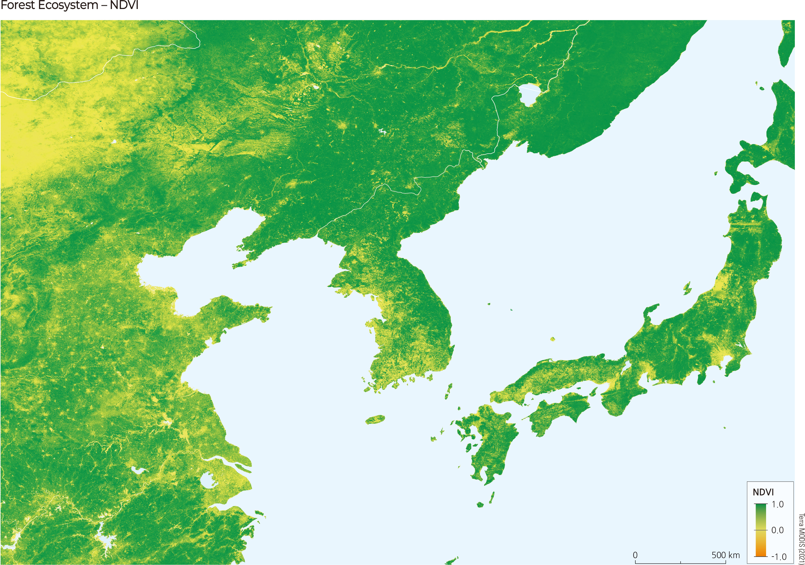
The Normalized Difference Vegetation Index (NDVI), which identifies the spatial distribution of vegetation from remote sensing imagery, is useful not only for distinguishing vegetation from surrounding objects but also for measuring relative vegetation vigor. In Korea, more than 60% of the national territory is forested, providing a wide range of ecosystem services supported by a diversity of forest ecosystems and high biodiversity. Therefore, it is important to continuously monitor the health of forest ecosystems and establish conservation plans. However, conducting field surveys over vast forest areas requires substantial time and labor. By calculating NDVI from remote sensing imagery, it is possible to remotely and cost-effectively detect forest damage from natural disasters and assess tree vigor, thereby improving the efficiency of forest ecosystem monitoring. In Korea, the Korea Forest Service actively employs remote sensing techniques alongside field surveys for forest monitoring. Accordingly, forest type maps, forest soil maps, and forest water maps are produced and made publicly available through the Forest Spatial Information Service. This enables various stakeholders to conduct monitoring, establish conservation plans, and explore sustainable use strategies for Korea's forests.
|
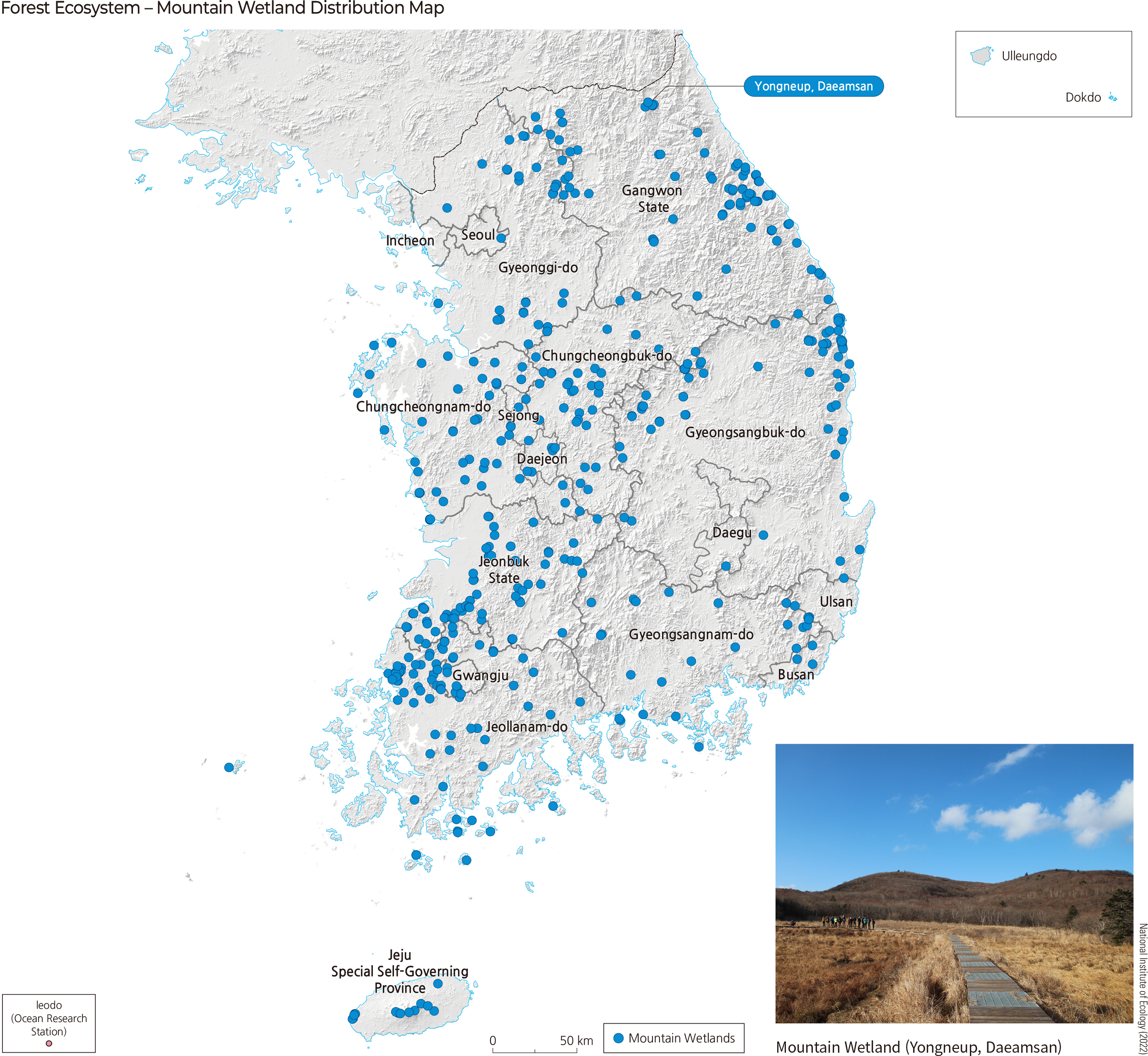
Wetlands are generally areas where moisture determines habitat conditions and the survival of plants and animals. Because changes in microclimate, soil, or water supply can rapidly alter conditions, wetlands are among the ecosystems most vulnerable to climate change and human threats. Mountain wetlands host fewer species than typical wetlands but provide unique habitats for particular plants and continuously supply moisture to the headwaters of streams. Accordingly, mountain wetlands are recognized as refuges and hotspots of biodiversity. Because mountain wetlands excel at carbon storage and are often located in relatively inaccessible areas—making them highly conservable—they have been the focus of various studies.
Mountain wetlands in Korea are broadly classified into natural wetlands, abandoned paddy wetlands, and artificial wetlands. Natural wetlands arise from natural causes, abandoned paddy wetlands are former cultivation sites in forests that have been left fallow, and artificial wetlands are constructed for agricultural activities, such as reservoirs. As of 2021, there were 455 mountain wetlands nationwide, covering approximately 276.2 ㎢. Vascular plants native to these sites comprise 927 taxa (113 families, 423 genera, 819 species, 23 subspecies, 78 varieties, and 7 forms). This accounts for about 20% of all vascular plants on the Korean Peninsula. Since forest ecosystem health stems from biodiversity and forest biodiversity is based on vegetation diversity, conserving the high plant species diversity of mountain wetlands is crucial.
|
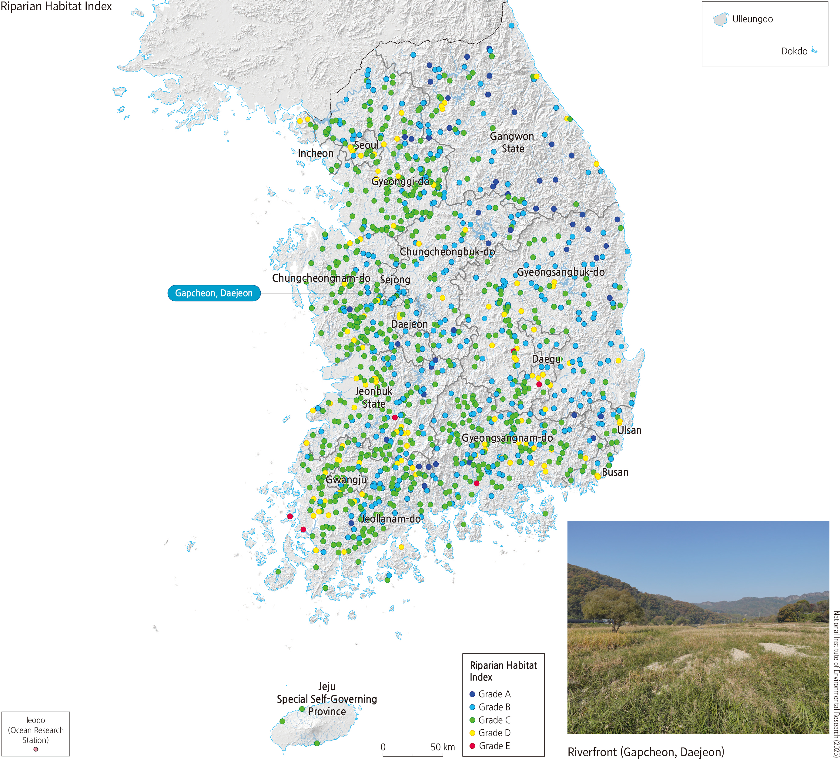
River ecosystems in Korea encompass not only major rivers such as the Hangang, Geumgang, and Nakdonggang but also small local streams, forming a broad ecosystem. These rivers are divided into mountain streams, upper, middle, lower reaches, and estuaries according to terrain and flow velocity, and differences in the physical and chemical environments of each section lead to substantial variation in species composition and distribution. For example, upper reaches and mountain streams have low water temperatures, fast flow, and high oxygen levels, whereas in lower reaches and estuaries, increased temperature and nutrient inputs raise biodiversity. The basic structure of river ecosystems is linked through food chains: phytoplankton (producers) are consumed by herbivores (zooplankton, aquatic insects, minnows), which are preyed upon by primary carnivores (crucian carp, carp), and then by secondary carnivores (catfish, snakehead). However, in upper reaches and mountain streams, low temperatures limit phytoplankton growth, so food webs are primarily based on leaf litter and organic matter. There, herbivorous aquatic insects such as caddisflies break down and consume leaf litter, after which carnivorous insects or small fish prey on them, maintaining the energy flow.
Currently, river ecosystems face serious threats from human activities. Chemical pollutants not only deteriorate water quality but, along with river channelization, have caused the loss of natural river morphology. In addition, the construction of various hydraulic structures has obstructed fish migration routes, making it difficult for them to reach spawning grounds and weakening ecological connectivity. As a result, biodiversity declines, food webs become imbalanced, and overall ecosystem functions deteriorate. These issues go beyond simple pollution, leading to the loss of ecosystem services and highlighting the need for sustainable management.
|
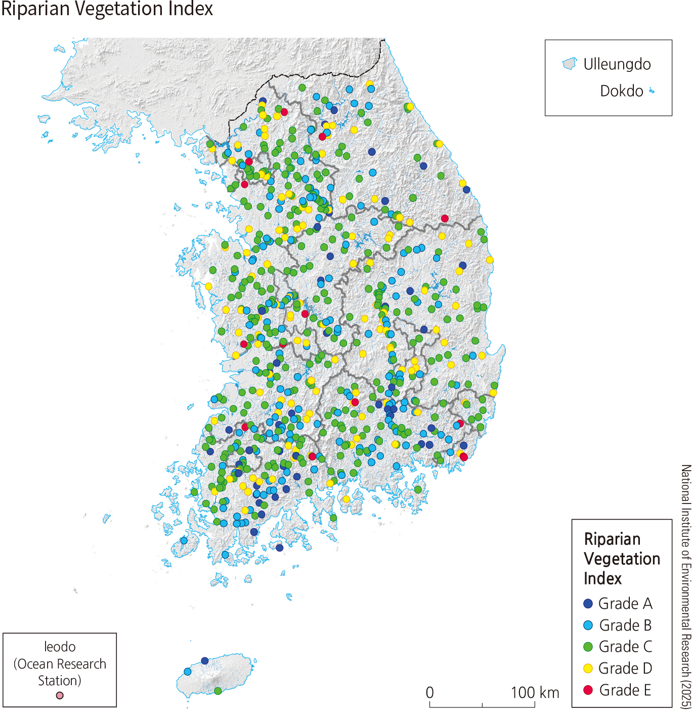
For evaluating aquatic ecological health, biological indicators such as riparian habitat conditions, riparian vegetation, fish, periphytons, and benthic macroinvertebrates are measured to compute the Habitat and Riparian Index (HRI), Riparian Vegetation Index (RVI), Fish Assessment Index (FAI), Trophic Diatom Index (TDI), and Benthic Macroinvertebrate Index (BMI). Based on these results—considering species diversity and abundance and the physical environment—ecosystem health is evaluated and classified into five grades: Excellent (A), Good (B), Fair (C), Poor (D), and Very Poor (E). Thus, systematic accumulation and assessment of field survey data are essential to securing the sustainable health of river ecosystems and ultimately provide the foundation for long-term ecological stability and resilience.
|
Korea is surrounded on three sides by the sea, and the coastlines of the South and West Seas are particularly intricate, resulting in long shorelines. In addition, thousands of islands of various sizes further increase the total length of the coastline. The coast is the zone where land meets the sea, linking terrestrial and marine ecosystems. For this reason, unique transitional ecosystems not found elsewhere are observed at the interface between terrestrial and marine environments.
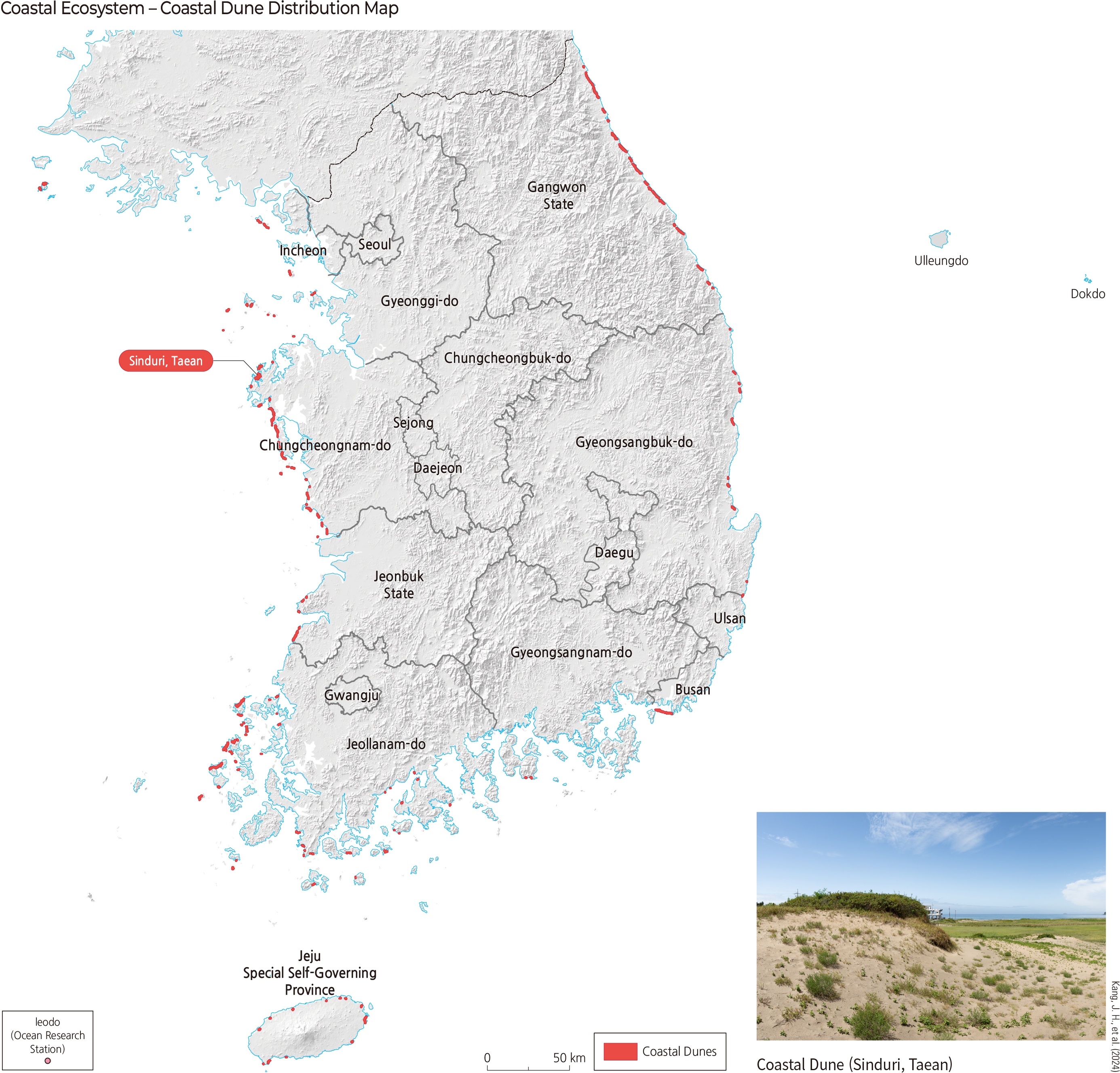
Coastal dunes are sand ridges formed when beach sand, transported by ocean currents and coastal currents, is blown inland and accumulates parallel to the shoreline. In Korea, coastal dunes are mainly distributed along the West and East Seas. Coastal dunes act as reservoirs of beach sand and groundwater and, ecologically, as transition zones linking marine and terrestrial ecosystems. These areas are fundamentally terrestrial environments composed of sand, but when groundwater emerges at the surface to form dune wetlands, they also take on wetland characteristics. Moreover, because the sand originates from the sea, it tends to exhibit higher salinity than inland sand. Therefore, biotic communities inhabiting coastal dunes possess unique characteristics rarely found elsewhere. For example, plants commonly observed in Korean coastal dunes—such as Zoysia sinica, Glehnia littoralis, Calystegia soldanella, Messerschmidia sibirica, and Carex kobomugi—are terrestrial species that are specifically adapted to the high salinity of dune sands.
Since 2003, the Ministry of Climate, Energy and Environment has collected ecological information on coastal dunes through a nationwide detailed coastal sand dune survey. Through this effort, detailed data on dune formation processes, conservation status, and ecological conditions are generated, enabling the development of effective management plans to protect high quality coastal dune ecosystems through evaluation of their functions and values.
|
Tidal flats are submerged at high tide and exposed at low tide. In Korea, tidal flats are mostly distributed along the West and South Seas. These areas consist mainly of silt and sand and are generally very flat. Tidal flats host numerous invertebrates such as polychaetes and crustaceans. Fish such as gobies also inhabit these areas, as well as microscopic phytoplankton. Birds use tidal flats as habitats and fly to them at low tide to feed on clams and small fish. Plants grow where tidal submergence is infrequent. Because tidal flat sediments are strongly influenced by seawater, halophytes inhabiting these areas are adapted to high salinity. Salicornia and Suaeda species, which redden the Yellow Sea tidal flats in Korea, are representative halophytes.
In 1999, Korea enacted the Coastal Management Act and the Wetlands Conservation Act to protect these areas. As coastal wetlands, tidal flats are legally recognized for their ecological value, and biodiversity conservation is promoted through the establishment of a basic wetland conservation plan. Korean tidal flats also serve as stopover sites for internationally endangered migratory waterbirds and support exceptionally high levels of biodiversity. For these reasons, the Seocheon, Gochang, Shinan, and Boseong-Suncheon tidal flats have been inscribed as UNESCO World Heritage Sites.
|
The East, West, and South Seas of Korea each display distinct marine-ecological characteristics. In the East Sea, the East Korea Warm Current and the North Korea Cold Current intersect, and differences in temperature and salinity create environments suitable for diverse fish species. In the Yellow Sea, river inflows from Korea and China result in relatively low salinity and high nutrient concentrations compared to other seas. The South Sea has high marine species diversity, including species typically found in warmer regions worldwide, such as the Indo-Pacific bottlenose dolphin, which can be found around Jeju Island.
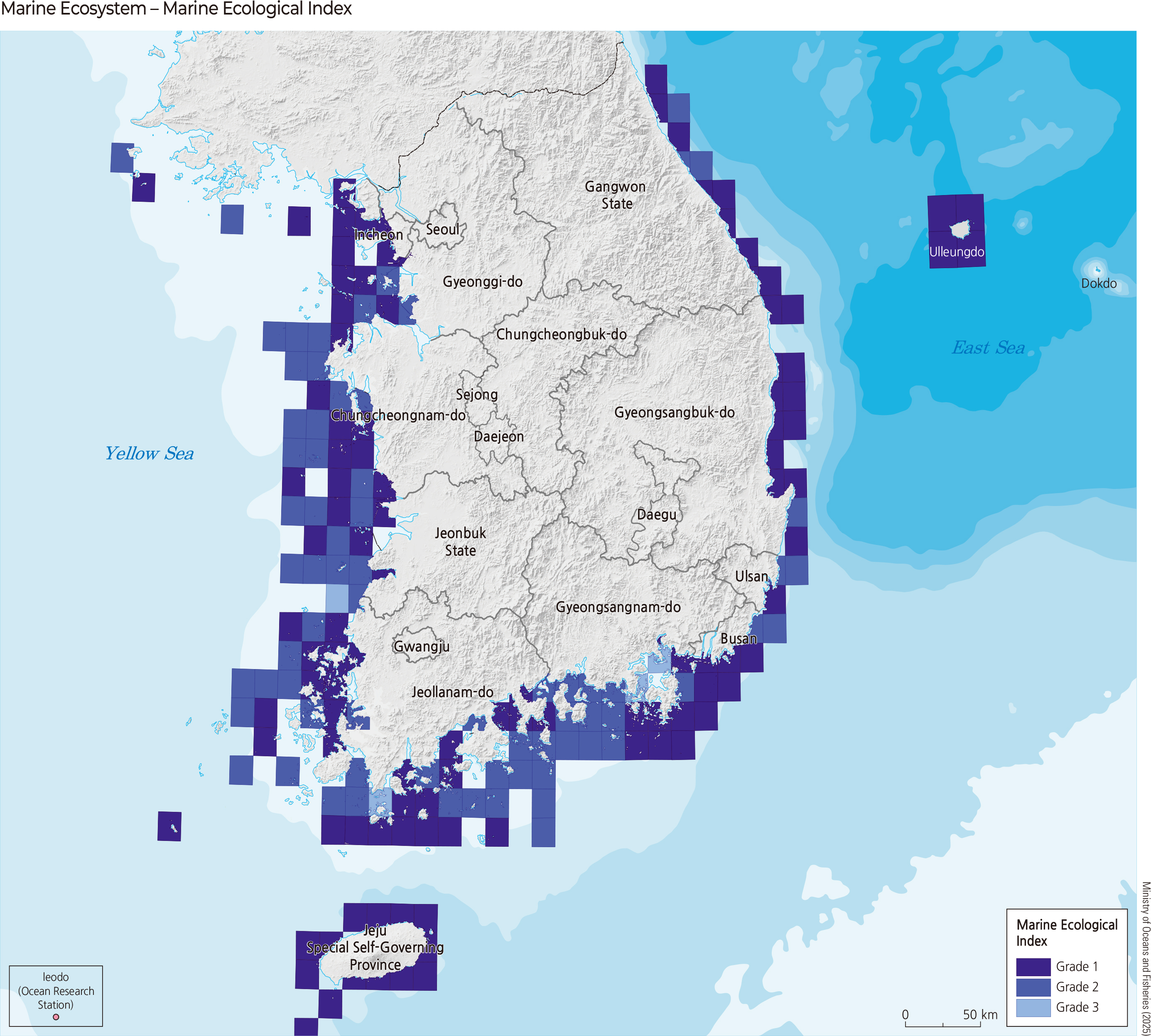
The Marine Ecology Map, based on the Marine Ecosystem Act, grades the ecological and landscape values of marine ecosystems nationwide using the National Comprehensive Marine Ecosystem Survey and the National Detailed Marine Ecosystem Survey. Basic data used for grading include planktonic organisms that drift with water flow, benthic organisms living on the seabed, nekton capable of swimming, and data from marine environmental surveys. A Grade 1 zone denotes areas and waters where marine ecosystems are particularly outstanding or marine landscapes are especially scenic. Such zones may include primary habitats, spawning grounds, or key migration routes of protected marine species; locations at the biogeographic limits of species; representative types of marine vegetation; and areas with particularly rich marine biodiversity and highly valuable marine biological resources. Grade 2 zones are areas with future conservation value or areas outside Grade 1 zones that are necessary for protecting the Grade 1 zones. Grade 3 zones are those not classified as Grade 1, Grade 2, or separate management areas and may be subject to development or use.
|
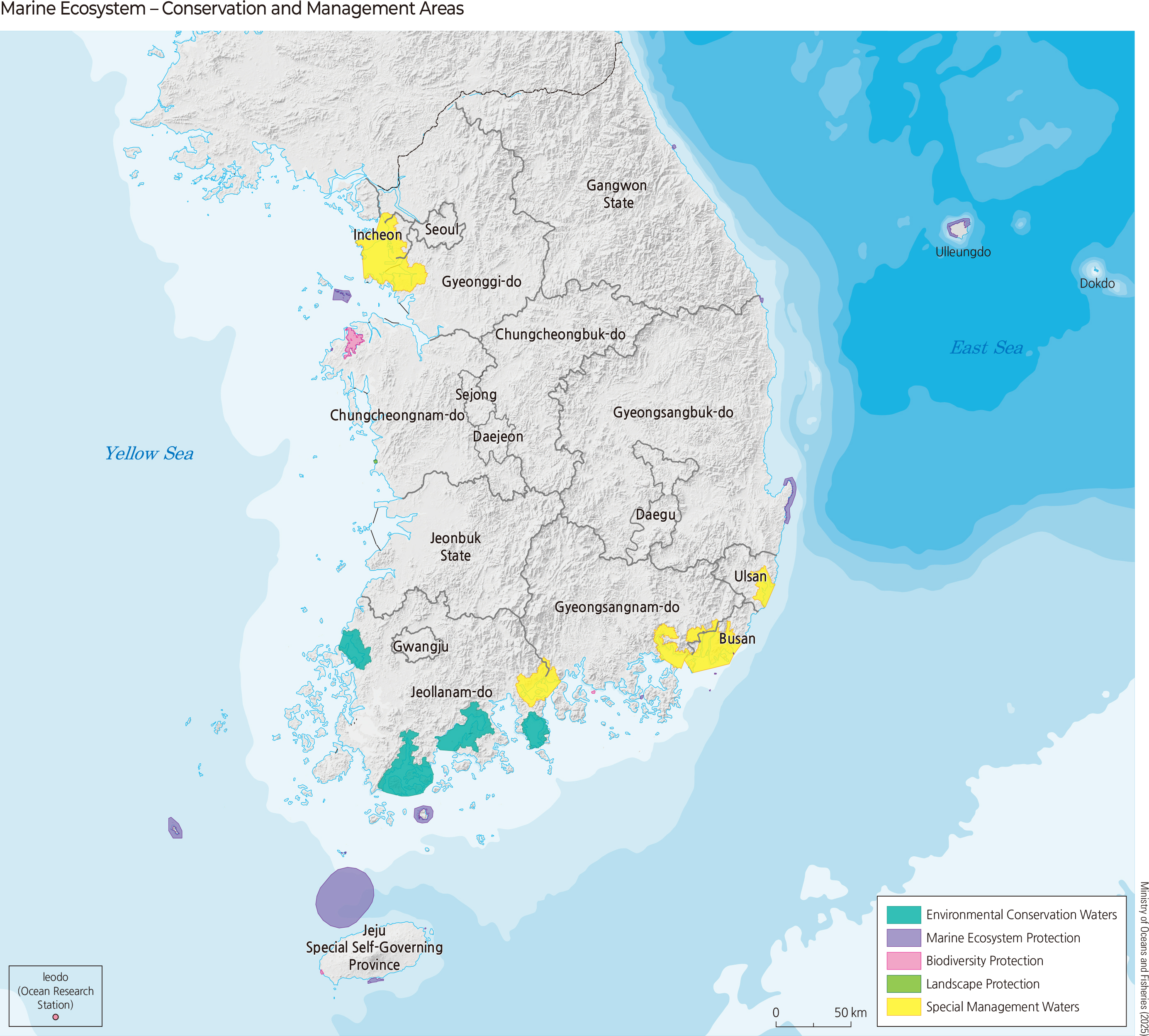
A Protected Marine Area is a zone designated and managed by the nation or local governments in specific public waters to conserve marine ecosystems and seascapes of special value. Protected Marine Areas designated under the Marine Ecosystem Act are selected based on criteria such as ecosystem naturalness, biodiversity, geomorphological, geological, and ecological uniqueness, productivity, presence of protected species habitats, ecological representativeness, and scenic beauty. Once designated, these areas are managed to protect marine organisms, ecosystems, and landscapes, with management objectives established for each area and progress evaluated through continuous monitoring. Local stakeholders—including residents, civic groups, and academia—participate as co-managers to enhance the ecological, economic, and socio-cultural values of Protected Marine Areas. Since the designation of the Sinduri Coastal Sand Dune as a Protected Marine Area in October 2002, additional protected areas have been continuously designated.
Environmental Management Sea Areas began to be designated in 2000 following legal revisions in the 1990s, and include the environmental conservation water and special management water. An environmental conservation water refers to waters designated within natural environment conservation areas for the protection and cultivation of fishery resources or waters requiring continued conservation due to their good marine environmental condition. A special management water denotes waters where maintaining marine environmental standards is difficult and where serious obstacles to marine environmental conservation exist or are likely to occur. The management of Environmental Management Sea Areas follows five principles: sustainability, integrated management, precautionary management, ecosystem-based management, and participatory and cooperative management.
|
|
.png)